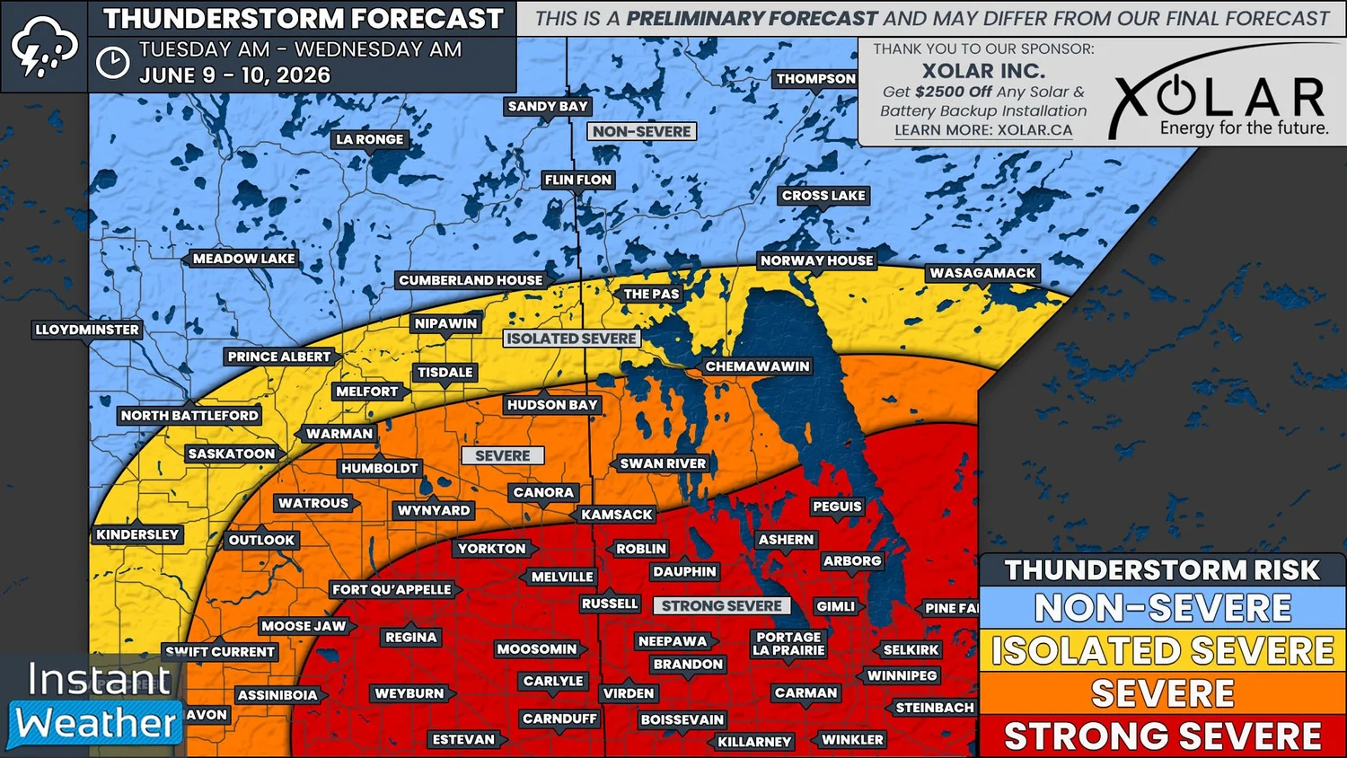
Threat of Large Hail, Damaging Winds and Tornadoes Returns to Saskatchewan and Manitoba on Tuesday
/
NOTE: YOU CAN CLICK ON THE MAP TO OPEN A ZOOMABLE IMAGE
It was a very busy weekend for severe weather in Southeastern Saskatchewan and Southwestern Manitoba. From the two day span, there have been countless reports of massive hail, wind damage, flooding from across the region, as well as a few tornado reports that are awaiting confirmation. Unfortunately, Monday’s calmer conditions won’t last because strong severe thunderstorms are once again expected to impact Southern Saskatchewan and Manitoba on Tuesday.
Early Tuesday, a low pressure system will move into Southeastern Montana and from there, it will strengthen as it tracks into Western North Dakota through the morning hours and into the afternoon. A warm front will extend eastward from the low pressure center, which will help draw lots of heat and moisture northward into Southern Saskatchewan and Manitoba.
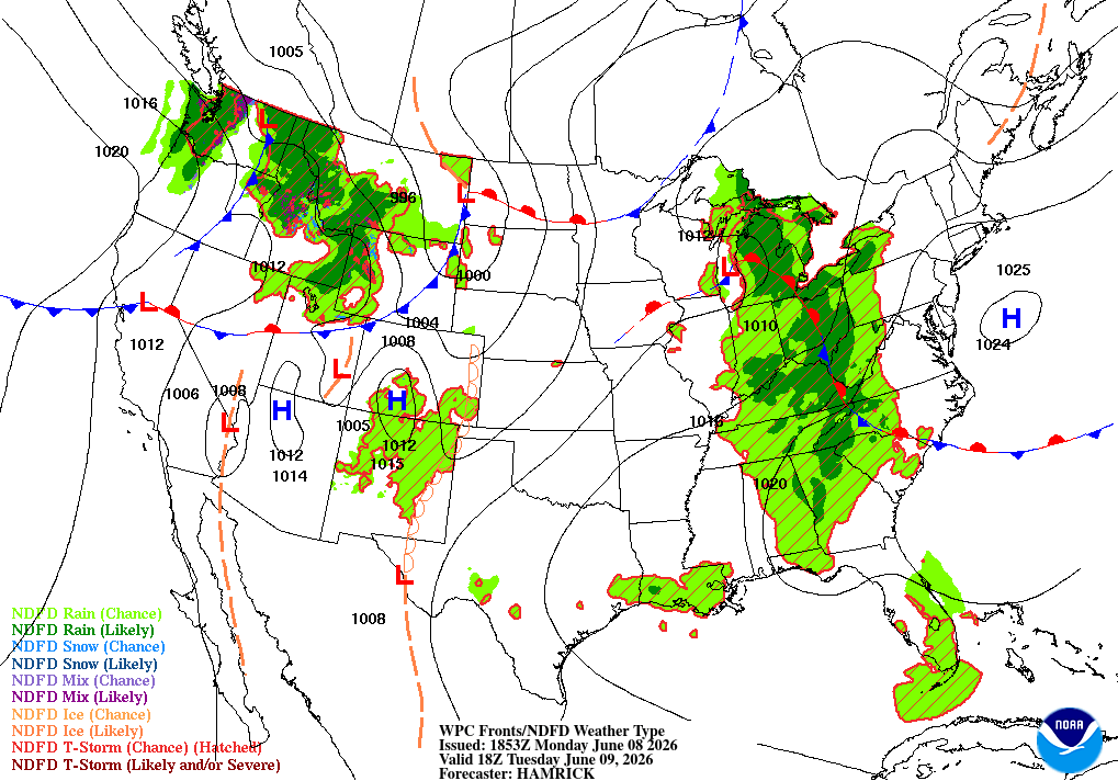
Future Surface weather map with the positions of highs, lows, and fronts displayed for 12pm cst/1pm CDT on Tuesday, courtesy of the national weather service.
Temperatures are slated to climb into upper 20s and low 30s across the region in the afternoon and with dewpoints expected to be in the upper teens, there will be plenty of fuel for thunderstorm development. Some models are showing upwards of 4000J/kg of CAPE in some areas, which will support the development of supercell thunderstorms.
Veering winds will also create a significant amount of shear to maintain large supercell thunderstorms and support tornado potential. Overall, this is looking like a fairly similar environmental setup to Sunday.
During the late morning, there is a chance that some thunderstorms could develop in Southeastern Saskatchewan which would track northeastward into Southwestern Manitoba into the early afternoon hours. These storms will likely become severe and produce some small hail and strong winds, but they won’t be as strong as the storms expected later in the day. However, if these storms manage to persist across the Interlake Region, they could end up re-intensifying through the late afternoon and evening.
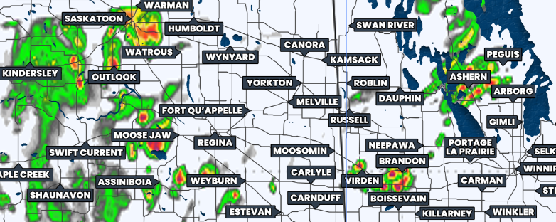
Simulated reflectivity at 4pm CST/5pm CDT, courtesy of weatherbell.
The strong severe thunderstorms could start to fire up in the early afternoon, particularly in Southwestern and West Central Saskatchewan. However, we will gradually see more organized development occur across Southern Saskatchewan and into Southwestern Manitoba as we get later in the afternoon, around 3-6pm, depending on the time zone.
Similar to what we saw on the weekend, the thunderstorms are expected to grow exponentially into large supercells which will track mostly northeastward through the evening and overnight.
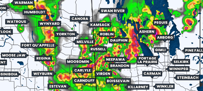
Simulated reflectivity at 8pm CST/9pm CDT, courtesy of weatherbell.
More thunderstorms are expected develop during the evening and storms will also move into the region from south of the border. As with the situation on both Saturday and Sunday, there is the likelihood that these additional storms will end up merging into a large line of thunderstorms. These thunderstorms will continue to be quite strong for a few hours after they transition into a linear storm mode.
As the hours tick on and it gets closer to midnight, it’s likely that the storms will begin to gradually weaken. This is also around the time that the severe line will make its way into the Winnipeg area so it’s possible that the city could avoid the greatest severe hazards of the day.
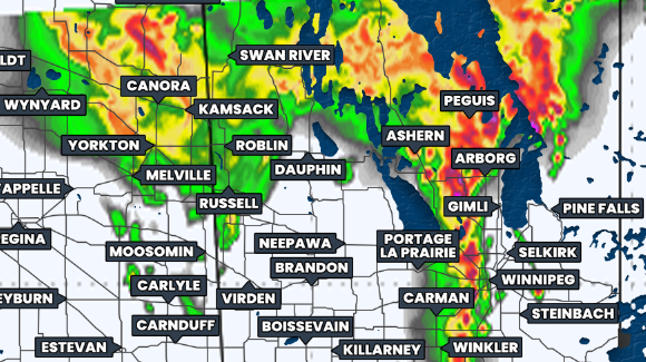
Simulated reflectivity at 11pm CST/12am CDT, courtesy of weatherbell.
The risk of strong severe thunderstorms on Tuesday extends across much of Southern Saskatchewan and Manitoba. Throughout this region, the severe thunderstorms could end up producing hail that’s larger than golf balls, widespread damaging wind gusts up to 130km/h, and torrential downpours that could exacerbate the flooding issues some communities are already dealing with.
There is also the potential for tornadoes to form from these thunderstorms. The major hindrance to tornado development over the weekend was that a lack of moisture ended up keeping the cloud bases high until they were able to lower later in the evening on Sunday. This could end up being the case on Tuesday, given the similar environmental setup, but the risk is certainly still in place.
Please keep in mind that this is a preliminary forecast and could differ from our final forecast as more data comes in overnight and tomorrow morning.