Potential Derecho Combined with Threat of Baseball Hail and Tornadoes Marks the Return of Extreme Risk in Saskatchewan and Manitoba Tuesday
/

NOTE: YOU CAN CLICK ON THE MAP TO OPEN A ZOOMABLE IMAGE
It was a very busy weekend for severe weather in Southeastern Saskatchewan and Southwestern Manitoba. From the two day span, there have been countless reports of massive hail, wind damage, flooding from across the region, as well as a few tornado reports that are awaiting confirmation. Unfortunately, the calmer conditions we saw on Monday will come to an end when strong severe thunderstorms once again impact Southern Saskatchewan and Manitoba today.
Through the day, a low pressure system will strengthen as it moves from Southeastern Montana into Western North Dakota and then into Southeastern Saskatchewan and Southwestern Manitoba by later this afternoon. A warm front will extend eastward from the low pressure center, which will help draw lots of heat and moisture northward into Southern Saskatchewan and Manitoba.
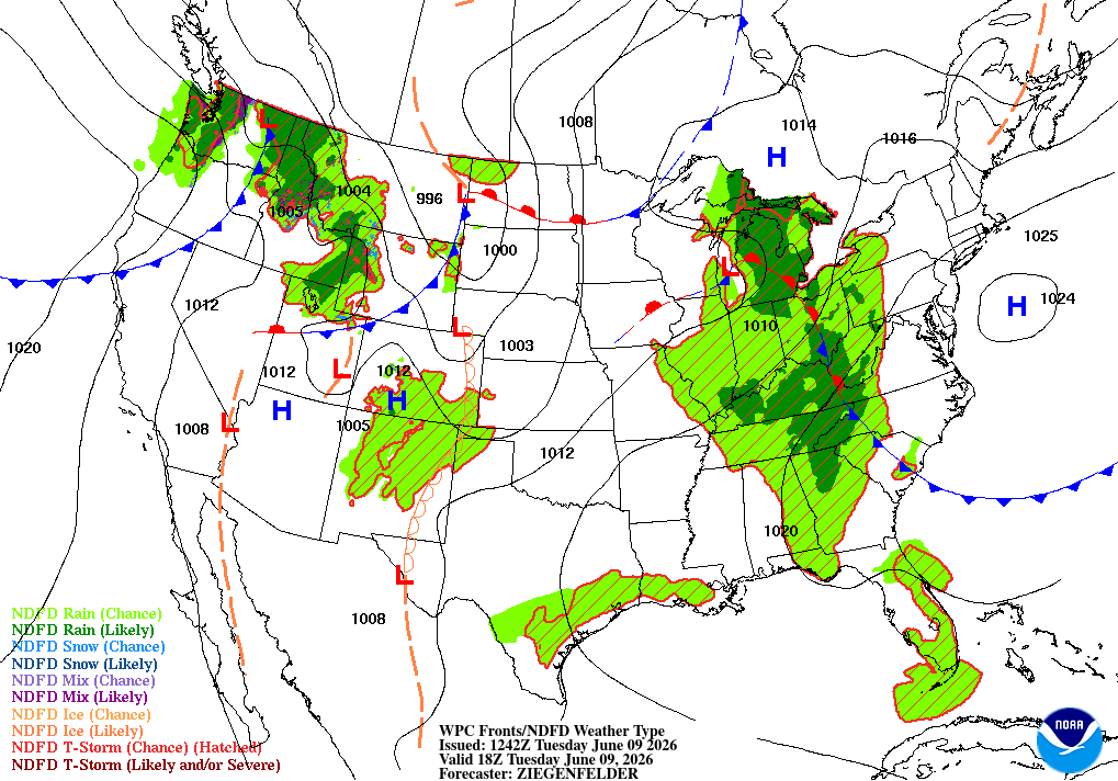
Future Surface weather map with the positions of highs, lows, and fronts displayed for 12pm cst/1pm CDT on Tuesday, courtesy of the national weather service.
Temperatures are slated to climb into upper 20s and low 30s across the region this afternoon and with dewpoints expected to be in the upper teens, there will be plenty of fuel for thunderstorm development. Weather models are showing upwards of 4000J/kg of CAPE in some areas, which will support the development of supercell thunderstorms. Veering winds will also create a significant amount of shear to maintain large supercell thunderstorms and support tornado potential.
Through the morning, there is a chance that some thunderstorms could develop in Southeastern Saskatchewan which would track northeastward into Southwestern Manitoba during the early afternoon. These storms could possibly become severe and produce some small hail and strong winds, but they won’t be as strong as the storms expected later in the day.
Simulated reflectivity at 3pm CST/4pm CDT, courtesy of weatherbell.
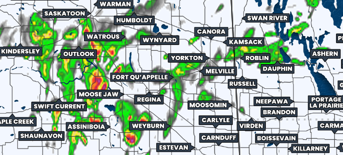
Severe thunderstorms could start to fire up in the early afternoon, particularly in Southwestern and West Central Saskatchewan. However, we will gradually see more organized development of stronger thunderstorms occur across Southern Saskatchewan and into Southwestern Manitoba as we get later in the afternoon, around 3-6pm, depending on the time zone.
Similar to what we saw on the weekend, the thunderstorms are expected to grow exponentially into large supercells which will track mostly northeastward through the evening and overnight.
Simulated reflectivity at 7pm CST/8pm CDT, courtesy of weatherbell.
Even more thunderstorms are expected develop during the evening and storms will also move into the region from south of the border. As with the situation on both Saturday and Sunday, there is the likelihood that these additional storms will end up merging into a large line of thunderstorms. These thunderstorms will continue to be quite strong for a few hours after they transition into a linear storm mode.
As the hours tick on and it gets closer to midnight, it’s likely that the storms will begin to gradually weaken. This is also around the time that the severe line will make its way into the Winnipeg area so it’s possible that the city could avoid the greatest severe hazards of the day.
Simulated reflectivity at 11pm CST/12am CDT, courtesy of weatherbell.
The risk of strong severe thunderstorms extends across much of Southern Saskatchewan and Manitoba today. Across much of the region, there will be the possibility for storms to produce ping pong ball hail, damaging wind gusts up to 100km/h, and heavy rains that will likely result in localized flooding.
However, the greatest threat of severe weather will once again be in Southeastern Saskatchewan, into Southwestern Manitoba and extending eastward into the Interlake Region and approaching the Red River Valley. This region, highlighted in red and purple on our forecast map, could see some exceptionally strong thunderstorms this evening that will originate from Montana.
The main threat from the thunderstorms that move through this region is expected be widespread destructive wind gusts upwards of 130km/h and this could very likely end up being considered a derecho. On top of this, the storms will also have torrential downpours that could further exacerbate the flooding issues being faced by some communities and they may produce hail that could be as large as baseballs, which could be extremely dangerous if it’s being driven by winds up to 130km/h. As if this wasn’t enough, there is also a tornado risk across this region.
The major hindrance to tornado development over the weekend was that a lack of moisture ended up keeping the cloud bases high, until they were able to lower later in the evening on Sunday. This could end up being the case today, but this still has the potential to be a life-threatening situation.
Even without the tornado risk, today’s severe weather threat is very serious. If you live in the area that we’ve highlighted in either red or purple on our map, PLEASE be prepared for the likelihood that threatening weather could impact your area today. Make sure you have your phones charged and you have multiple ways to receive weather alerts. It’s also a good idea to have a plan in place in the event that you need to take shelter.