Two EF1 Tornadoes Confirmed Northeast of Edmonton From Monday, May 26th, 2025

NOTE: YOU CAN CLICK ON THE IMAGE TO OPEN A ZOOMABLE VERSION

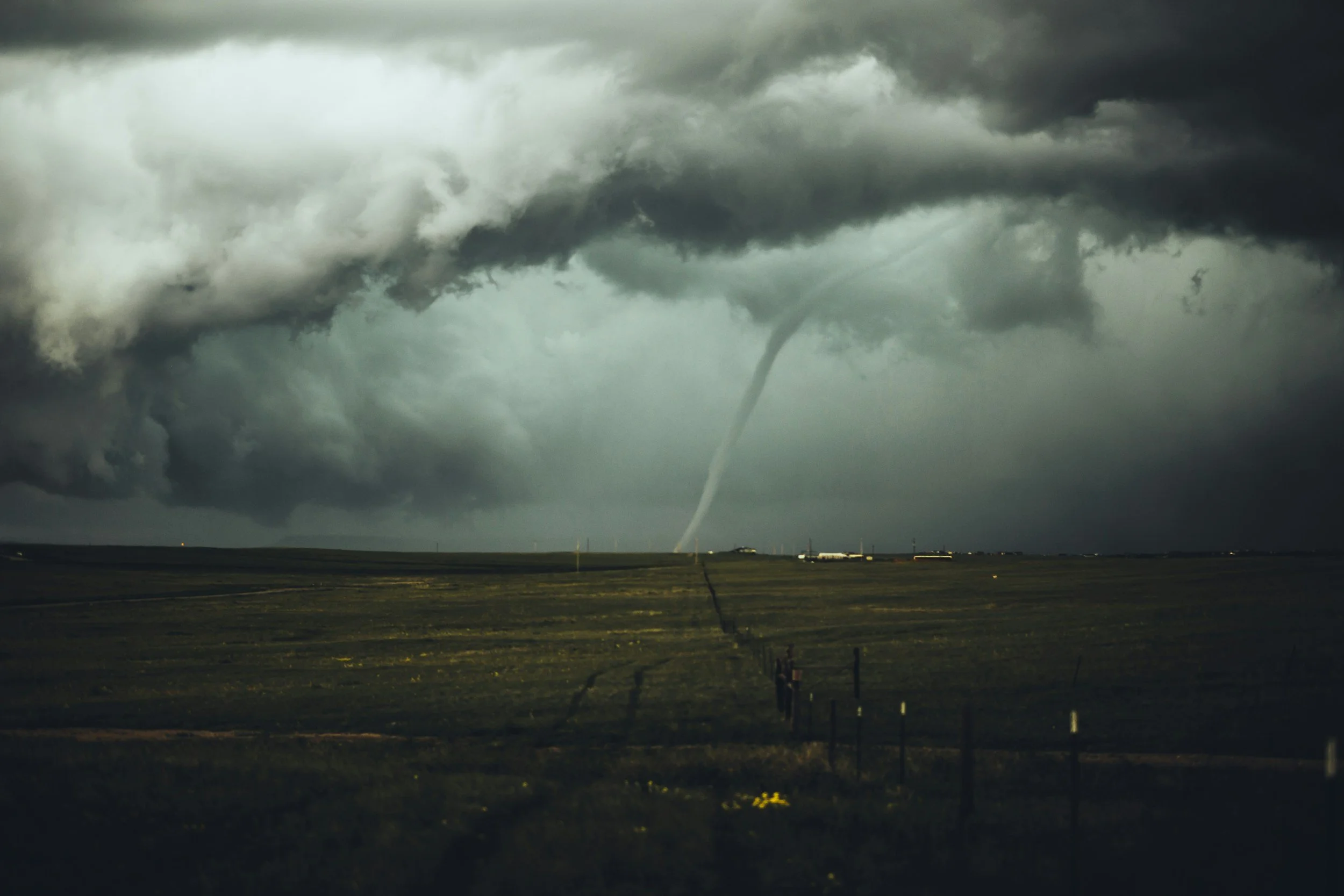
Two EF1 tornadoes have been confirmed in Alberta from May 26th, 2025 by the Northern Tornadoes Project (NTP). Thankfully, there were no injuries with these two tornadoes. The strongest of the two was on the ground for an impressive 21.2km and had estimated wind speeds of 175km/h. The two tornadoes touched down near Lac la Biche and left behind lengthy, narrow paths of damage, including a partially removed roof from a home and numerous snapped and uprooted trees.

Investigators from the NTP conducted thorough ground and drone surveys on May 28th and noted that Alannah and Patricia from our own Instant Weather team helped get their team deployed quickly. The NTP wrote: “Thanks to Alannah and Patricia at Instant Weather for their initial (late-night) alert to the damage, allowing us to get our team out faster!” We at IW are grateful that we were able to help NTP with their investigation and super thankful that no one was injured in these two tornadoes. The NTP meticulously documented the aftermath and their findings paint a clear picture of the two separate twisters that tore through the region.


The Atmore Twister – A Lengthy Path of Damage

NOTE: YOU CAN CLICK ON THE IMAGE TO OPEN A ZOOMABLE VERSION

The first tornado, designated the "Atmore" event, began its destructive journey at approximately 7:00 PM MDT (0100 UTC) on May 26th.

Final EF-Scale Rating: EF1

Estimated Max. Wind Speed: 175 km/h

Track Length: A substantial 21.2 km

Max. Path Width: 300 m

Motion: From the Southwest (approx. 220 degrees)

NOTE: YOU CAN CLICK ON THE IMAGE TO OPEN A ZOOMABLE VERSION

This twister carved a significant path, causing notable damage to homes near Atmore and Rossian (north of Plamondon). Reports detailed structural impacts and the NTP survey confirmed these, along with extensive tree damage. Satellite imagery review also highlighted the visible tree damage along its long, narrow track. Luckily, despite the substantial property damage, no injuries were reported.

NOTE: YOU CAN CLICK ON THE IMAGE TO OPEN A ZOOMABLE VERSION


The Avenir Tornado – A Shorter, Wider Impact

NOTE: YOU CAN CLICK ON THE IMAGE TO OPEN A ZOOMABLE VERSION

Just 25 minutes after the Atmore tornado began, a second EF1, named the "Avenir" event, touched down further to the northeast at approximately 7:25 PM MDT (0125 UTC).

  • Final EF-Scale Rating: EF1

  • Estimated Max. Wind Speed: 150 km/h

  • Track Length: 6.43 km

  • Max. Path Width: A slightly wider 370 m

  • Motion: From the South-Southwest (approx. 205 degrees)

NOTE: YOU CAN CLICK ON THE IMAGE TO OPEN A ZOOMABLE VERSION

While shorter in track length, the Avenir tornado left a clear signature, primarily impacting forested areas near the community of Avenir. Satellite imagery initially revealed its narrow path of tree damage, which was later confirmed and documented by the NTP's ground and drone survey. As with the Atmore event, no injuries were reported in connection with this tornado.

NOTE: YOU CAN CLICK ON THE IMAGE TO OPEN A ZOOMABLE VERSION


Understanding the Findings

The Northern Tornadoes Project plays a crucial role in confirming, classifying and analyzing tornado damage across Canada. Their use of satellite imagery, followed by on-the-ground surveys with drones, allows for precise classification and understanding of these powerful weather phenomena.

These EF1 tornadoes, with wind speeds reaching up to 175 km/h, serve as a reminder of the potential for severe weather in Alberta. While not the most powerful on the Enhanced Fujita (EF) Scale, they are certainly capable of causing significant localized damage, as evidenced by the events near Lac la Biche.

Find out more & get notified

  • You can view precise tracks of these tornadoes and explore other Canadian tornado and downburst events on the interactive NTP Dashboard.

  • Always have a plan for severe weather and download our free app Instant Weather to get notified of any alerts from Environment Canada or any custom updates from the IW team regarding rotation, funnel cloud reports, etc.

Forty Years Since Black Friday: Looking Back at the Historic Tornado Outbreak and the Barrie F4 From May 31st 1985

The damaged ‘welcome to Barrie’ sign following the f4 tornado that hit may 31st, 1985, courtesy of the Barrie Banner.

On this day in 1985, Southern Ontario experienced violent thunderstorms which produced an outbreak of 14 tornadoes, part of a larger outbreak of 44 tornadoes that also impacted Ohio, Pennsylvania, and New York. This stands as the third largest tornado outbreak in Canadian history and one of the tornadoes from that day was the 7th deadliest on record in Canada.

A total of 88 people lost their lives that day; 8 were in Barrie, two were in Grand Valley, two were in Tottenham, and the rest of the fatalities occurred in the US. Hundreds of people were left homeless across Southern Ontario and total damage from the 14 tornadoes is estimated at well over $100 million (in 1985 dollars).

It was all over in six hours and now, May 31st, 1985 is referred to as Black Friday.

The daily weather map from the morning of may 31st, 1985, Courtesy of the National Weather Service.

Meteorological Background

The day began with a low pressure system settled over Northern Minnesota and Wisconsin and an associated cold front stretching over Lake Superior and Michigan’s Upper Peninsula, then southward through Lake Michigan and into the Midwest. This system drew in warm, moist air from the Gulf and cool, dry air from the north. It was being driven by a strong upper-level jet stream so as the cold front rapidly swept eastward through the Gulf air mass, it triggered explosive development of severe thunderstorms.

The satellite loop below shows how the thunderstorms developed through the afternoon and evening across the region as the cold front swept through.

The Visible satellite loop from the afternoon of May 31st, 1985 showing the development of thunderstorms, courtesy of the National Weather Service.

Analysis of the upper air charts shows that winds at the 850mb level were 40 knots (74km/h) and at the 300mb level, they were 100 knots (185 km/h). The winds also changed direction with height which meant the atmosphere had plenty of both vertical speed shear and directional shear, which create rotation in thunderstorms and is a crucial ingredient in the formation of tornadoes.

Environment Canada saw this set up and they proactively issued a Severe Weather Watch at 7am, well ahead of the cold front. The storms started to develop over Lake Huron at 1:40pm and quickly intensified into a line of storms by 2:00pm. At 2:25pm, Environment Canada issued its first Severe Weather Warning of the day, which included the reminder that some severe thunderstorms produce tornadoes.

The line of storms continued to develop over the next couple of hours, travelling eastward at up to 70km/h, and the warnings were subsequently expanded. At 3:45pm, severe thunderstorm warnings extended into Simcoe County and then along the west end of Lake Ontario at 4:53pm as the southern end of the line of storms intensified.

The first tornado warning of the day was issued at 5pm, following confirmation of a touchdown near Shelburne, but it was far too late for the communities that were hit the hardest.

The timing of severe thunderstorm warnings, tornado warnings, and tornado touchdowns from May 31st, 1985, courtesy of Leduc, Jacobson, and Greer.

The tracks of thirteen tornadoes from the May 31st, 1985 outbreak with the Grippen Lake Tornado noticeably missing, courtesy of Leduc, Jacobson, and Greer.

Timeline of Tornado Development

The entire outbreak began in Southern Ontario, with a tornado touching down near Rush Cove in the Bruce Peninsula at approximately 3:00pm. It was rated an F2 and was on the ground for approximately 4km. This tornado is interesting because it was much earlier and well removed from the other tornadoes in this outbreak. The remaining 13 tornadoes can actually be grouped into separate families because there were spawned by the same parent supercells.

As the cold front continued to march eastward through Southern Ontario that afternoon, the thunderstorms and the formation of tornadoes travelled along with it. Following the Rush Cove tornado, there was a lull in tornadic activity until shortly after 4pm. Over the course of the following hour, 7 tornadoes spawned, ranging in intensity from an F1 to two F4 tornadoes.

At 4:10pm, an F2 dropped near Hopeville, northwest of Shelburne and it travelled 17km. Then, at 4:15pm, two separate tornadoes developed: an F3 in Alma, to the northwest Fergus, which was on the ground for 33km, and a devastating F4 which touched down near Arthur. This F4 was on the ground for a staggering 115km, setting the record for the longest tracking tornado ever in Canada, and produced estimated maximum wind gusts in excess of 400km/h. It brought significant damage to both Grand Valley and Tottenham, located 50km to the east. Sadly, two people lost their lives in each of these communities.

Damage in Grand Valley following the F4 tornado, courtesy of the Orangeville Banner.

Two minutes later, an F2 touched down near Corbetton, to the northwest of Melancthon. This tornado came from the same supercell thunderstorm as the Hopeville tornado, which had formed only seven minutes prior. This tornado was on the ground for 35km, more than double that of its predecessor.

A little over half an hour later, at 4:50pm, an F2 hit the community of Lisle, to the west of Base Borden, which was also spawned from the same supercell as the Hopeville tornado. It was on the ground for 18km and then seven minutes later, the same storm dropped another tornado just east, an F1 near Essa, which was on the ground for only half a kilometre. The final tornado that this storm produced was the most deadly and destructive of the day, the Barrie F4, which will be discussed in more detail below.

When the Grand Valley-Tottenham tornado finally lifted after being on the ground for well over an hour, its parent supercell went on to produce two more tornadoes: an F1 that touched down north of Uxbridge at 5:40pm and was on the ground for 5km, and another F1 that hit Reaboro, southeast of Lindsay, at 6:05pm and was on the ground for 8km.

While the two main supercells to the north continued to produce multiple tornadoes between 4:00pm and 6:00pm, the thunderstorm behind the Alma tornado didn’t produce another until two hours later, when an F2 touched down east of Highway 35 at 6:15pm, which later tore through Ida along its 9km track. Five minutes later, this storm produced an F3 that travelled 14km along the north shore of Rice Lake and then 15 minutes after that, a final F1 touched down that was on the ground for only 1km near Minto, to the north of Trenton.

This marks 13 total tornadoes from this outbreak and this is what the tally stood at for many years. It wasn’t until around 2010, two and a half decades later, when scientists at Environment Canada were compiling a tornado database, that a missing report from the defunct Kingston Weather Office was found. It detailed damage caused by an F1 tornado which touched down around 8:10pm near Grippen Lake, to the northeast of Kingston. It remains unclear as to why this report was never submitted, but the inclusion of this tornado brings the final number of tornadoes in Southern Ontario on Black Friday to fourteen.

One of the few photos known to exist of the rain-wrapped Barrie Tornado, taken by Gary Crawford from HIghway 11 beside the Drive-In Theatre in Guthrie (edge of Oro). Donated to Instant Weather by Mr. Crawford.

The Barrie F4 Tornado

The Barrie tornado was the strongest of the 14 that touched down on Black Friday, with winds estimated at over 400km/h, making it the second F4 tornado of the day.

The tornado was rain-wrapped as it touched down just outside of the city in a reforestation area, where it snapped many trees and permanently bent even more. It was initially 600m wide, carving a significant path as it approached the edge of Barrie.

As it moved northeastward into the city, the tornado levelled an entire block of homes in the Crawford Street and Patterson Road area, then hit an industrial area known as Molson Park. From there, the tornado turned to travel eastward and crossed Highway 400, terrifying many commuters as their vehicles were pelted by intense winds and debris.

After crossing the Highway, the tornado narrowed to roughly 300m wide and it began devastating the Allendale neighbourhood in the south end of Barrie, destroying homes and uprooting mature trees. Once it ploughed through this built up area, the tornado once again began travelling northeastward. It lastly hit a marina on Kempenfelt Bay before moving out over the water, where it finally dissipated. Given that the end of the tornado’s path of destruction concluded over water, the exact length of its track can not be concretely known, but it is estimated that it was on the ground for approximately 15km.

It was all over in a matter of minutes, but the tornado left scars that would take years to heal.

The initial Draft of the Official survey of the Barrie F4 tornado done by Scott Somerville at Environment Canada, Courtesy of Michael Newark Tornado Digitized Archive by the Northern Tornadoes Project.

Damage & Aftermath

The destruction brought to Barrie was staggering. In a matter of minutes, 155 people were injured, approximately 800 were left homeless, and damage was initially estimated at over $115 million. Sadly, eight residents lost their lives, including four children.

A total of 605 homes were severely damaged and of those, 265 were deemed uninhabitable. In one case, a townhouse complex just east of Highway 400 had its top storey removed and even sections of the main level. Meanwhile, fifteen industrial buildings west of the highway were completely destroyed and many more sustained significant damage. Vehicles were thrown hundreds of metres and 35 sailboats in Kempenfelt Bay completely disappeared.

Damage in Barrie following the F4 tornado, Courtesy of CTV News.

It took well over a year for the residents of Barrie to rebuild following the F4 tornado and this tornado alone ended up causing $130 million ($334 million in 2025 dollars) in damage. This does not even cover the physical and mental damage experienced by the residents, some of which can never be repaired.

The City of Barrie chose to commemorate this tragic event with two plaques: one for those who lost their lives and one for those who helped the community rebuild.

Damage in Barrie following the F4 tornado, Courtesy of CTV News.


Sources:

Harries, K. (Ed.). (1985). Ontario tornado: May 31, 1985. C.F. Boone.

Leduc, M., Jacobson, O., and Greer, B. (1986). The “Black Friday” tornado outbreak in Ontario: A forecaster’s view of the events of May 31, 1985. Chinook, 8(1), 13-18.

Witten, D. E. (1985). May 31, 1985: A deadly tornado outbreak. Weatherwise 38(4), 193-198. https://doi.org/10.1080/00431672.1985.9933314

https://www.cbc.ca/archives/the-tornadoes-that-tore-a-deadly-path-of-destruction-in-ontario-in-1985-1.5575434

https://www.ctvnews.ca/barrie/article/marking-37-years-since-devastating-ontario-tornadoes/

https://www.ctvnews.ca/barrie/article/may-31-1985-the-day-the-sky-unleashed-fury-on-central-ontario/

https://www.theweathernetwork.com/en/news/weather/severe/may-31-1985-outbreak-how-a-lost-14th-tornado-was-found

https://www.theweathernetwork.com/en/news/weather/severe/this-day-in-weather-history-may-31-1985-the-barrie-grandvalley-tottenham-tornadoes

https://www.uwo.ca/ntp/faqs/what_are_canadas_worst_tornadoes.html

https://www.weather.gov/cle/event_19850531_85outbreak

https://www.weather.gov/ctp/TornadoOutbreak_May311985

Special thanks to Dr. David Sills at the Northern Tornadoes Project for his help in answering some inquiries when writing this article.

Ontario’s First Confirmed Tornado of 2025: EF0 Touches Down Near Woodstock Last Week

NOTE: YOU CAN CLICK ON THE MAP TO OPEN A ZOOMABLE IMAGE

Ontario’s tornado season has officially begun. The first confirmed tornado of 2025 touched down during the early morning hours of May 16th, just south of Lakeside, Ontario, northwest of Woodstock.

The tornado developed along the leading edge of a line of storms that had tracked into the province from Michigan.

While this EF0 tornado near Lakeside was the first confirmed in Ontario this year, it wasn’t the first in Canada.

According to the Northern Tornadoes Project, this brings Canada’s confirmed tornado count for 2025 to five.

The season began with an EF0 tornado in Alberta in early April, followed by an EF1 in Quebec later that month. Just one day before the Lakeside event, two EF0 tornadoes were confirmed in Manitoba on May 15th.

With peak season still ahead, this serves as a timely reminder that severe weather can happen quickly and under conditions that don’t always look extreme on the surface.

Even low-end risks deserve attention, especially when storms arrive at night, when people are less likely to be tuned in.


The Tornado: A Narrow but Confirmed Touchdown Near Lakeside

Survey map for the Lakeside EF0 tornado (source: Northern Tornadoes Project)

According to the Northern Tornadoes Project (NTP), the tornado developed just south of the village of Lakeside, approximately 25 km northwest of Woodstock. It touched down around 3:00 AM EDT, shortly after a squall line of thunderstorms entered the region from the west.

Drone photo of worst damage point featuring multiple snapped conifers (source: Northern Tornadoes Project)

Damage was limited to trees and a power pole, with no injuries reported. The tornado was assessed as an EF0, with estimated maximum wind speeds of 115 km/h. It travelled a distance of 3.6 km, with a maximum path width of 160 metres, moving generally from the west-southwest (255°).

Radar data shows possible rotation near lakeside (source: iw pro)

Radar imagery at the time showed a compact area of low-level rotation, but due to the storm’s embedded structure and the overnight timing, the event went unwitnessed until damage was reported later that day.

The NTP conducted both ground and drone surveys on May 20th to confirm the tornado’s track and intensity.

This information is sourced from the Northern Tornadoes Project’s full report, which can be found here.

Survey map showing the location of the EF0 downburst (black oval) and collected data (source: Northern Tornadoes Project)

In addition to the confirmed tornado near Lakeside, the Northern Tornadoes Project also verified a separate EF0 downburst near Chatham from the same storm system.

The downburst occurred around 2:15 AM EDT, roughly 45 minutes before the tornado, and caused significant damage to several barns, farm buildings, power poles, and trees.

While similar wind damage was reported across parts of Southwestern Ontario—from Windsor to Shrewsbury—only the enhanced damage south of Chatham was surveyed.

Wind speeds were estimated to have peaked at 130 km/h, placing the event at the high end of the EF0 scale. No injuries were reported.


Timeline: Forecast Leading Up to the Tornado

Forecast models began flagging the potential for severe storms several days in advance, particularly in Deep Southwestern Ontario, where the environment appeared favourable for severe weather.

Instant Weather and the U.S. Storm Prediction Center both noted the possibility of tornadoes — albeit marginal — due to the timing and nocturnal nature of the storms. This provided over 24 hours of advance notice about the potential for severe weather.

Despite the lower-end risk, one storm managed to spin up a brief EF0 tornado shortly after 3:00 AM on May 16th.


Instant Weather first highlighted the tornado potential on Wednesday afternoon, referencing the Storm Prediction Center’s forecast and the setup in Michigan and Southwestern Ontario:

The following morning, just under 24 hours before the confirmed tornado, Instant Weather once again flagged the risk.

This time, the post specifically mentioned that a 2% tornado risk extended into Sarnia, Chatham, Grand Bend, and as far northeast as London, placing the affected area firmly within the broader risk zone:

Later Thursday afternoon, a forecast was issued by Instant Weather calling for the potential of isolated tornadoes overnight. The forecast map outlined a marginal risk that included the area near Lakeside, where the tornado would eventually touch down:

Around 1:47 AM, just over an hour before the tornado touched down, Instant Weather sent out a custom notification for the London area, referencing minor rotation and clearly stating that “an isolated tornado cannot be ruled out”:

At 2:55 AM, Environment Canada issued a Severe Thunderstorm Warning, which included a note that severe thunderstorms can produce tornadoes. This came approximately five minutes before the tornado would touch down near Lakeside

Finally, live coverage was underway on Instant Weather’s YouTube channel during the time the tornado developed around 3:00 AM, as the storm moved through Oxford County.

Last Year Was a Record-Breaking Tornado Season in Canada, According to Northern Tornadoes Project

The Northern Tornadoes Project (NTP), based out of Western University in London, Ontario, has just released their annual report on the 2024 tornado season. In it, the organization highlights that last year was a record-breaking year in terms of the length of the season.

Canada’s first tornado of the year was recorded in Malden Centre, Ontario on March 16th, coincidentally tying a tornado that hit Clifford, Ontario on March 16th, 2016 as the earliest recorded Ontario tornado. There were then a series of several late-season tornadoes that the NTP recorded: three individual twisters in New Brunswick on November 1st and the final tornado of the year near Fergus, Ontario on November 10th.

All told, this makes the 2024 tornado season 240 days long, over a span of nine different months. This is considerably longer than the typical season, which usually only has tornadoes in six separate months, from April to September. At this length, 2024 was the longest tornado season since at least 1980.

Another substantial finding in the report is that the 2024 tornado season was marked by the second-most tornadoes verified by the organization in a single season since their inception in 2017, with 129 tornadoes confirmed nationwide. A large spike in the total number came after the completion of the season, when the team could conduct further investigation and satellite review, which subsequently included an additional 16 tornadoes to the tally!

Most of the year’s tornadoes were rated as weak EF0s and EF1s, but the NTP did record 12 EF2 tornadoes. While this is double the amount from 2023, it is well below the 30+ recorded in both 2021 and 2022, both very active tornado seasons. Of these EF2 tornadoes, all but one (the Wolverton-Ayr tornado in Southern Ontario) occurred in forested areas of Northern Ontario and Quebec.

The Locations of all Tornadoes from 2024 and their corresponding EF-Scale Ratings, Courtesy of the Northern Tornadoes Project.

Geographically, Ontario was the province which was home to the most tornadoes this past season, with 50 tornadoes on land and 10 over water, which makes up almost half of all recorded tornadoes for the year. Out of the 50 tornadoes on land, 14 of them spawned during outbreaks on two individual days: June 29th had six and July 28th had eight. Quebec was the second-most active province, with 21 total tornadoes (four of which occurred over water), followed by Saskatchewan with 19.

At Instant Weather, we are a proud partner of the Northern Tornadoes Project. We developed our custom radar suite, Instant Weather Pro, in conjunction with the organization and the many weather reports from you, our community, help them in their mission.

For the upcoming 2025 season, the Northern Tornadoes Project team sounds excited to continue their work alongside the Northern Hail Project and the newly-founded Northern Mesonet Project. You can learn more about them at the Northern Tornadoes Project homepage and for more information regarding the report, you can find it here.