Heavy Rain, Damaging Wind Gusts and Freezing Rain Risk to Impact Southern Ontario on Thursday

NOTE: You can click on the map to open a zoomable image which will be easier to read.

As we end the first full week of February, a messy system is on the horizon for Southern Ontario on Thursday. Parts of our region could see up to 20-40mm of rainfall, damaging wind gusts near 90-100km/h for parts of the Lake Erie shoreline and several hours of freezing rain for Eastern Ontario. There is even the risk of non-severe thunderstorms in Deep Southwestern Ontario late Thursday!

This is all expected to start early Thursday morning as we see the first bands of precipitation enter Southwestern Ontario just after midnight. Temperatures for the most part will be above the freezing mark keeping any precipitation in the form of rain. However, we believe a pocket of colder air will lock in over the Dundalk Highlands keeping them just below the freezing mark for a few hours during the mid-morning hours. This means locations such as Hanover, Guelph, Kitchener, Orangeville and Shelburne could experience some freezing rain before temperatures warm up by late morning. Ice accretion of a few millimetres is possible in the hardest hit areas which will be the higher elevations northwest of the GTA.

By the afternoon on Thursday, the freezing rain risk will shift to the Ottawa Valley as we see the potential for prolonged freezing rain. This risk could linger into the evening with persistent freezing rain lasting 4-8 hours before tapering off just after midnight. Expect icy road conditions and even the possibility of localized power outages as total ice accretion could range from 5-10mm. The Algonquin Park region into areas just north of Muskoka will see some freezing rain, but snow and ice pellets will also mix in at times which means less icing is expected there. Snow will be the story in Northeastern Ontario where Sudbury and North Bay could see 10-20cm of snowfall accumulation by the end of Thursday.

NOTE: You can click on the map to open a zoomable image which will be easier to read.


Here is an advertisement so we can pay the bills:


Another concern with this system will bring strong to damaging wind gusts developing throughout the day on Thursday. The strongest gusts will be found along the northeastern shoreline of Lake Erie including Norfolk County and the Niagara region. These areas could see gusts exceeding 90km/h mainly during the afternoon and evening hours.

For the rest of Deep Southwestern Ontario, through the GTA and Lake Ontario shoreline, we will see strong winds with gusts around 80-90km/h, but it will be just below severe levels. Wind gusts of between 70-80km/h are possible from Southwestern Ontario through Lake Simcoe and into Southeastern Ontario. Central Ontario and the Ottawa Valley will see gusts remain under 70km/h.

NOTE: You can click on the map to open a zoomable image which will be easier to read.

While much of Southern Ontario will escape the freezing rain risk, there is another threat lurking with this system. That is the heavy rainfall with widespread totals ranging from 20-40mm including Southwestern Ontario, the Golden Horseshoe and parts of Eastern Ontario. This amount of rain during winter is quite significant and could lead to localized flooding in some areas.

Rainfall totals of between 15-30mm are expected from the Bruce Peninsula through Central Ontario and the Ottawa Valley. Less rain is expected in the more northern parts of Southern Ontario due to more freezing rain, ice pellets and snow. Although the flooding threat is still a concern as it will lead to the same amount of water once melted.

Be sure to stay safe and dry!


Here is another advertisement so we can pay the bills:

Potentially Record Breaking Wind Chill Temperatures Colder Than -35°C Will Occur Overnight Tonight and Early Tomorrow Morning

With having been a fairly mild winter so far across Nova Scotia, we’re in for a shock to the system with the frigid cold air that has been flooding in behind the morning’s cold front. The temperatures have plummeted throughout the day and we’ve already begun to see temperatures dip into the -20°s. The temperatures will continue to fall overnight and the minimum will occur in the early morning hours tomorrow. At the same time, there will be sustained winds of 30-60km/h and gusts up to 90km/h which will continue throughout the day. The morning is going to feel exceptionally colder and we’re looking at wind chills below -35°C across the province and in the Cape Breton Highlands, it may feel as cold as -50°C. To put things into perspective, these wind chill values could break records that are up to 40 years old!

By mid-morning, we will see the temperatures start to rise to the negative teens, and the wind chill values will rise above -30°C, for the afternoon. The snow squalls for Western Nova Scotia and the Annapolis Valley as well as Western Cape Breton Island, will continue overnight and through the day tomorrow. Up to 25cm of snow is possible locally from these snow squall bands and visibility will be significantly reduced due to blowing snow so use caution when travelling in this area as conditions could rapidly deteriorate.

When we’re dealing with this level of extreme cold, it’s important to remember that there is an exposure risk and frost bite times may be reduced to under 10 minutes with these wind chills. Make sure to dress warmly when going outside and keep your pets indoors whenever possible.

Snow Squalls Target Parts of Southern Ontario on Friday With Up to 15-30cm Possible

NOTE: You can click on the map to open a zoomable image which will be easier to read.


Here is an advertisement so we can pay the bills:


February is starting on a chilly note across Southern Ontario with the arrival of extremely cold temperatures late Thursday. This is courtesy of a sharp cold front cutting across the region which also sparked an intense snow squall that brought a brief shot of heavy snow across Southern Ontario on Thursday afternoon and evening.

For more information on the upcoming extreme cold, please check out our temperature forecast HERE

At this point in the winter, lake effect snow is usually not a concern considering that the lakes tend to be frozen over by now. That isn’t the case this year as the rather mild winter has led to very little ice coverage on the lakes. The bitterly cold air combined with a strong northwesterly flow will result in the development of snow squall activity off the southeastern shorelines of Lake Huron and Georgian Bay.

Bands of lake effect snow are expected to organize late Thursday evening or early Friday morning in the wake of the cold front passing through. The hardest hit regions appear to be the Grey-Bruce, Huron and Perth counties east of Lake Huron along with the southeastern shoreline of Georgian Bay including Collingwood and Wasaga Beach. Snow squalls will be ongoing throughout the day on Friday leading to locally hazardous conditions due to near-zero visibility and rapid snowfall accumulation. Travel within the affected regions is not recommended and at the bare minimum, be sure to leave plenty of time to get to your destination.

By the end of the day on Friday, we are looking at the highest snowfall totals ranging from 15-30cm including much of the regions east of Lake Huron and the Collingwood/Wasaga Beach area. Surrounding regions including Barrie and London could see some occasional snow squall activity as it shifts around throughout the day. Snowfall totals here could approach 10-20cm although this depends on the exact location of the squalls.

Snow squalls from Georgian Bay may also affect the Northern GTA including York Region and the Hwy 400 corridor between Barrie and Vaughan. We don’t expect anything overly significant in terms of accumulation here with up to 10cm, but the sudden whiteouts would be a big concern when it comes to driving conditions.

The lake effect snow is expected to briefly come to an end late Friday as a weak system moves into the region from the northwest early Saturday morning. Snow squalls may redevelop northeast of Georgian Bay on the weekend leading to accumulating snow around Parry Sound and North Bay. More details on that in a separate forecast to be posted on Friday.


Here is another advertisement so we can pay the bills:

Blast of Arctic Air Will Bring Frigid Temperatures As Low As -35°C Plus Windchill to Southern Ontario Beginning Tomorrow Morning

The line of snow squalls that has been moving across the region this afternoon and evening is along the leading edge of a sharp cold front that will be followed by the coldest air that Southern Ontario has experienced so far this season. Temperatures will plummet behind this front as it continues to push southeast across the region as cold Arctic air floods in behind it. Temperatures will hit a minimum tomorrow morning, from 6am to noon, before rising a few degrees throughout the day.

One of the concerns with this extreme cold is that, although light (in the 10-20km/h range), the winds will make it feel even colder. Windchills could be as cold as -45°C across Central and Eastern Ontario, reducing frostbite times to a little as 10 minutes. This Arctic air is going to persist throughout the day tomorrow before warmer air from the south starts to move into the region on Saturday morning. With these cold temperatures, make sure to stay warm and keep your pets indoors!

January Is Ending on a Snowy Note Across Southern Ontario With a System to Dump Up to 15-25cm of Snow on Sunday

UPDATED FORECAST

ISSUED: Saturday, Jan. 28, 2023 (2:00 PM)

Southern Ontario is bracing for yet another impactful snowstorm this weekend, with the latest data shifting the heaviest snowfall totals further south, extending from Kincardine through Collingwood, Muskoka, Bancroft, and Renfrew. Snowfall totals here will range from 15 to 25cm with locally up to 30cm.

Based on the southern shift, we are now expecting less mixing through the Greater Toronto Area (GTA), boosting potential snowfall totals ranging from 5-10cm along the lakeshore and up to 10-15cm further inland. Eastern Ontario is expecting 10-20cm, with slightly less in Prince Edward County due to rain mixing in near the Lake Ontario shoreline. The heaviest snow is expected to occur during the mid to late morning hours on Sunday.

Wet flurries transitioning to rain are expected by mid-morning in Deep Southwestern Ontario and the Niagara region, with snow tapering off by the afternoon as the system exits the region and moves into Quebec.


ORIGINAL FORECAST

NOTE: You can click on the map to open a zoomable image which will be easier to read.


Here is an advertisement so we can pay the bills:


While the weather started mild and quiet for most of Southern Ontario to begin the first month of 2023, the same can’t be said as we say goodbye to the remaining days of January. We are monitoring yet another potential storm that could bring significant snow to parts of the region on Sunday. This comes only days after a system dumped up to 20-25cm of snow across Southern Ontario on Wednesday leading to hazardous driving conditions and a lengthy cleanup that lasted throughout the week.

With this upcoming event, it will feel like deja vu as we experience similar totals, but the track appears to be slightly further north. This will mean that higher snowfall totals will be found east of Lake Huron and Georgian Bay as lake enhancement becomes a key component in providing extra moisture. While to the south, we could see some mixing in Deep Southwestern Ontario and around the Golden Horseshoe making for a tricky forecast regarding the overall snowfall totals.

We debated on even releasing a forecast this evening as models still disagree on where this mixing line will be located. Some models show less mixing around the GTA, allowing for snowfall totals to exceed 10cm. On the other hand, some models show a switchover to rain (especially closer to the shorelines) which would keep snow totals closer to a few centimetres if anything at all. This is why we emphasize that the forecast right now is very preliminary and will likely change once we get more data tonight and on Saturday.

Snow is expected to start late Saturday or pre-dawn Sunday as the system moves in from the west. The bulk of the snow will fall during the morning hours which is when we expect the worst conditions. It will begin to taper off later in the day with just scattered flurries by the late afternoon through the evening. For Southwestern Ontario, the precipitation will start as wet snow or showers and transition over to rain by the late morning. There is the potential for some brief freezing rain during the transition, but the environment isn’t favourable for widespread freezing rain.

Again as mentioned, the exact snowfall totals are still a little uncertain depending on the track and the extent of rain mixing in and reducing the snow accumulation. We do believe that a fairly widespread zone including the Grey-Bruce region, into Muskoka, Parry Sound and Bancroft could pick up between 15 to 25cm. Some models even indicate locally higher totals exceeding 30cm, but we’ve decided to stick to the 15-25cm range due to the uncertainty. An upgrade to the 20-30cm level in some areas isn’t out of the question.

Accumulation will drop off to the south with expected totals ranging from 10 to 20cm in locations such as Goderich, Northern Simcoe County, Peterborough and the Ottawa Valley. Southwestern Ontario and the GTA are currently on the line between very little snowfall accumulation and 10+ cm of accumulation. We will finalize this in our updated forecast on Saturday and provide a more exact accumulation range once we get a better idea of the extent of the mixing.


Here is another advertisement so we can pay the bills:

The Parade of Storms Continues with a Texas Low Bringing More Rain to an Already Drenched Nova Scotia

For the third time in the past week, there is a winter storm on our doorstep and this one is expected to bring heavy rain and very strong wind gusts across the province tomorrow. With all of the precipitation we’ve received over the past week, the ground is already saturated and this additional rain will likely cause localized flooding across the province.

Things will kick off around midnight with some light snow moving into Digby and Yarmouth Counties and rain in Shelburne County. This leading edge of precipitation will spread across the province through the early morning hours and the snow will only last an hour or two before transitioning to rain as the temperatures begin to rise behind a warm front. Overall, accumulation totals will be less than 5cm from this brief period of snow. Amherst and parts of Cumberland County can expect to be closer to 5cm which will decrease the total rainfall there to under 20mm. Due to increased elevation, the snow will last a bit longer for the Cape Breton Highlands and up to 10cm of snow is possible there before the transition to rain.

By approximately 5am, we’ll begin to see heavier rain moving in from the west and this will last for several hours. Rainfall rates up to 7mm per hour are not outside of the realm of possibility, especially along the Atlantic Coast where 40+mm of rain could fall.

The heavy rain throughout the day tomorrow will be accompanied by very strong southerly winds. Gusts of 70-90km/h will be felt across the province tomorrow and gusts could be 100+km/h along the Atlantic Coast. This has prompted Wind Warnings from Environment Canada that indicate the potential for localized power outages. The warm front will bring the daily high temperatures around 10° across the province, considerably warmer than today, but the high winds will make it feel several degrees cooler.

We will see the rain start to taper off beginning in the mid-afternoon and it will completely exit the region by 10pm. There may the odd scattered shower popping up overnight, but any rain will be light and short-lived.

Midweek Snowstorm on Track to Bring Up to 15-25cm of Snow Across Southern Ontario

NOTE: You can click on the map to open a zoomable image which will be easier to read.


Here is an advertisement so we can pay the bills:


A Texas low is set to affect Southern Ontario starting Wednesday, bringing something many across the region have been lacking this year, accumulating snow! The upcoming snowfall event will likely be the most significant thus far in the season for many areas excluding the lake effect snow we saw around Christmas. Widespread snowfall totals will range from 10-25cm with the highest amounts around the Golden Horseshoe and into Eastern Ontario. The heaviest snowfall will occur during the late afternoon and evening hours on Wednesday, making for a very tricky evening commute with snow-covered roads and reduced visibility.

There is still some uncertainty on the exact speed and strength of the system which could change the forecast slightly, but confidence is high enough to provide a rough idea in regards to timing and accumulation. Just keep in mind that this is a preliminary forecast and may need to be adjusted as we get closer to Wednesday. An updated forecast will be released late Tuesday based on the latest data.

We expect that the initial bands of snow will start to move into Deep Southwestern Ontario and areas around the Lake Erie shoreline by late Wednesday morning. Light to moderate snow will be ongoing throughout the afternoon and will continue to intensify later in the day as it approaches the Golden Horseshoe and the rest of Southwestern Ontario. As mentioned, we will see the most intense snowfall rates of up to 2-3cm per hour right during the evening rush hour which will add extra time to the commute for anyone travelling home after the work day.

There could also be some lake enhancement off the southwestern shoreline of Lake Ontario boosting the potential snowfall rates over the Hamilton, Oakville and Grimsby regions. For Eastern and Central Ontario, the snow will start by the early afternoon with the heaviest snow occurring during the evening into the early morning hours of Thursday. Snow is expected to taper off by sunrise on Thursday, but flurries could linger into the afternoon, especially in Eastern Ontario.

As we are expected to remain on the cold side of this system, the expected snowfall totals are fairly straightforward compared to previous events where mixing led to inconsistent accumulation. However, there could be some marginal mixing around the Lake Ontario shoreline and into the Niagara region if temperatures can get warm enough.

A fairly large zone encompassing Eastern Ontario and parts of Central Ontario and the Golden Horseshoe is currently expected to see totals ranging from 15 to 25cm by Thursday afternoon. A few locations mainly in Eastern Ontario and around Hamilton with the lake enhancement could locally see up to 30cm, but those totals will be extremely isolated.

The rest of Southern Ontario including Southwestern Ontario and the Niagara region (where some mixing could occur) are currently looking at totals around 10 to 20cm. Believe it or not, the lower snowfall totals will be found in Northern Ontario with North Bay seeing around 5-10cm and Sudbury getting a few centimetres at most!


Here is another advertisement so we can pay the bills:

Another Messy Winter Storm Will Bring Heavy Rain and Snow to Nova Scotia Tomorrow

Quick on the heels of the storm that brought a widespread 10-25cm of snow Friday and into Saturday morning, another storm will move into the region overnight tonight. This storm will bring snow and heavy rain across the province which, combined with warmer temperatures, will melt the snow from a couple of days ago and may create flooding issues.

Moving in from the southwest, the leading edge of the storm will begin to impact Western Nova Scotia around 10-11pm tonight. Precipitation will start off as snow as it spreads across the province through the early morning hours tomorrow. Areas along the Atlantic Coast, as well as Eastern Cape Breton Island, will only see trace amounts of snow and can expect almost entirely rain from this system.

By the time that the snow reaches as far as Sydney at around 4-5am, warm air will start to push its way across the province, resulting in a transition from snow to rain. The snow will linger in Northern Nova Scotia and the Cape Breton Highlands and these areas may see some mixed precipitation as the temperature will slowly rise and hover around 0° before finally transitioning to rain.

By 9am, the heavier rain will start to make its way across the province and it will continue into the afternoon. After several hours of heavy rain, there will be a break in the storm before the precipitation wraps around the backside of the low pressure centre of the storm in the evening, bringing several hours of additional light snow and rain overnight and into Tuesday morning. Most of this snow will fall in the Annapolis Valley and in Northern Nova Scotia and Western Cape Breton Island, where the most snow is already expected to fall.

Heavy Snow and Strong Winds Will Impact Eastern Newfoundland and the Avalon This Weekend Beginning Later This Evening

For the second week in a row, we will have a storm to close out the week in Newfoundland. This week, however, there is just snow in the forecast, along with strong winds, and the main target will be Eastern Newfoundland and the Avalon.

A low pressure system will pass south of Nova Scotia today and the outer edge of snow will push into the Burin and Avalon Peninsulas as well as parts of the South Coast this evening, around 5-7pm. Overnight, the snow will spread north to cover the Bonavista Peninsula and extend west to include Gander.

The heaviest snow from this system is expected to fall in the Eastern Avalon, including the St. John’s Metro, at a rate of 2-3cm per hour for a few hours. The Avalon can expect 15-30cm of snow from this storm, but the Eastern Avalon could possibly see 30-40cm with the possibility of 40+cm locally.

Overnight Friday and through the day Saturday, there will be wind gusts of 60-80 km/h coming from the northeast. This will reduce visibility with blowing snow, possibly making travel difficult at these times.

The snow will begin to taper off for the Burin Peninsula and the rest of Eastern Newfoundland Saturday evening and overnight, but it will continue in the Avalon until the early morning hours Sunday. Outside of Eastern Newfoundland, there is the chance of a few centimetres of snow, but the rest of the Island can expect trace amounts of snow up to 5cm through the weekend.


Largest Snowfall of the Season for Most of Nova Scotia Will Hit Friday

After a record low amount of snowfall for most of Nova Scotia, tomorrow’s storm will help change that with widespread amounts of 10-20cm expected by Saturday afternoon. Halifax could easily triple its season total for snow just from this one event!

The snow will approach from the southwest, first impacting the Yarmouth area at around 3:00am tomorrow morning. From there, it will spread across the province during the morning, reaching Sydney by noon. The heaviest snow is expected to fall during the morning in Western Nova Scotia at a rate of 2-2.5cm per hour which could last for up to 4 hours for the South Shore and into Halifax. This region will likely exceed 20cm of snow and there is a chance of up to 30cm. On the other hand, there will be a sliver of Western Cape Breton Island, including Cheticamp, where the snow will be steady, but light through the storm and 5-10cm of snow can be expected.

The snow will continue through the day tomorrow and will start to dissipate overnight in the west before making its way out of the province completely by noon on Saturday. There may be some isolated flurries in Cape Breton Island in the early afternoon Saturday, bring an additional couple of centimetres by the evening.

It’s important to note that the rain from this system will not be too far offshore so there is a slight chance for some mixed precipitation right along the Atlantic Coast. Any freezing rain will be brief and should not have much impact on total snow accumulation.

The daily forecast map is being included in this forecast because it’s fairly straight forward for tomorrow. The high temperatures will be 0° or a degree or two higher across the province with the snow that will be occurring throughout the day.

Active Weather Continues Across Southern Ontario With Another Winter Storm on the Horizon to End the Week

NOTE: You can click on the map to open a zoomable image which will be easier to read.


Here is an advertisement so we can pay the bills:


It sure appears that Mother Nature is making up for the lack of storms earlier in the season across Southern Ontario with yet another system set to bring messy weather over the next few days. The exact impact of this winter storm will vary depending on your location with those through Central and Eastern Ontario seeing mostly snow and ice pellets. While to the south, our focus will be on a prolonged risk of freezing rain for a wide swath of Southwestern Ontario and the GTA. There is even the risk of a non-severe thunderstorm around the Windsor and Chatham region late Thursday!

Impacts from this system will begin to be felt just after midnight tonight for Deep Southwestern Ontario coming in the form of rain. Rain will continue across this area with the potential for a non-severe thunderstorm in the evening. Total rainfall accumulation will range from 20-40mm although it might be higher should we see a thunderstorm.

As the bands of precipitation slowly spread to the northeast, it will encounter a layer of colder air locked in at the surface making for the perfect environment for freezing rain. An expansive area of freezing rain will develop across Woodstock, K/W, Guelph, Orangeville and parts of the GTA away from the shoreline during the mid to late morning hours on Thursday.

This is very temperature dependent and even just one degree could be the difference between significant freezing rain and normal rain. Those closest to the Lake Ontario and Huron shorelines will see slightly warmer temperatures allowing for a faster switchover to rain by the late morning. Away from the lakeshore, especially in the higher elevations of the Dundalk Highlands, the freezing rain could linger well into the afternoon leading to prolonged icing and potential power outages. The remaining regions throughout Southwestern Ontario and the GTA will see a transition over to rain by the late afternoon.

Total ice accretion is expected to max out at around a few millimetres along the shorelines which will be quickly melted away by the switchover to rain. Those in higher elevations including K/W, Guelph, Orangeville and Newmarket could see upwards of 6-12mm of icing throughout the day on Thursday. This amount of icing would certainly lead to icy road conditions and localized power outages. Travel isn’t recommended here until conditions improve later in the day and we will likely see school bus cancellations for Thursday.

Those in Central and Eastern Ontario will be on the cold side of this storm with ice pellets and heavy snow being the primary concern. Precipitation here will start sometime during the afternoon beginning as an ice pellet and snow mix with more snow further to the north along the Quebec border and Northeastern Ontario.

As the system progresses through the region late Thursday, we expect the southern parts of the aforementioned regions such as Barrie, Peterborough and Kingston to see some freezing rain mixing in with the ice pellets and snow. Freezing rain and drizzle may continue to pose an issue throughout the evening and into the overnight hours.

The highest snowfall totals will be found in Northeastern Ontario including Sudbury and North Bay which could see as much as 10-20cm by the end of Friday. General snowfall totals will range from 5 to 10cm across Central and Eastern Ontario with lower amounts to the south as more ice pellets and freezing rain mix in and reduce the potential accumulation.

As the system exits the region overnight and into Friday morning, we will see colder air flood in behind it. As a result, any remaining precipitation is expected to transition over to flurries by Friday morning. Light snow will continue to fall across Southern Ontario throughout the day on Friday, but we aren’t expecting any significant accumulation.


Here is another advertisement so we can pay the bills:

Freezing Rain Risk Threatens to Disrupt the Tuesday Morning Commute Across Southern Ontario

NOTE: You can click on the map to open a zoomable image which will be easier to read.


Here is an advertisement so we can pay the bills:


The weather story across Southern Ontario throughout the weekend has been dominated by what most would consider as ‘perfect’ winter weather. While the temperature was colder than we’ve been used to this winter, it was accompanied by a rare sight - the sun! As we start the week, our attention will turn to the potential for freezing rain starting early Tuesday morning and lingering throughout the afternoon.

The overall severity of this freezing rain event is expected to be fairly minor with 2-4mm of ice accretion at most. However, the main concern will be because of the timing as it collides with the busy morning commute throughout the GTA. This is certainly enough ice to create slick driving conditions out on the roads, especially on untreated surfaces. As a result, expect travel delays on Tuesday and potentially even some school bus cancellations.

We will start to see patchy freezing rain move into our region just after midnight starting with Southwestern Ontario as it slowly progresses to the northeast. Locations such as London and parts of Grey-Bruce counties could see a few hours of freezing rain before switching over to rain. Those closest to the Lake Huron shoreline and the Windsor/Chatham region should remain above the freezing mark throughout this event.

By the mid-morning hour just before dawn, an expansive band of freezing rain is expected to stretch through Kitchener-Waterloo and across the GTA. Several hours of freezing rain lingering into the late morning hours is likely, especially in higher elevations like Guelph and Orangeville. Freezing rain will transition to rain by the noon hour with those closest to the shoreline such as Downtown Toronto seeing a quicker switchover. Total accretion of a few millimetres is possible away from the lakeshore.

The heaviest freezing rain is expected across southern parts of Central and Eastern Ontario including Barrie, Muskoka, Peterborough and Kingston. Freezing rain will start by the late morning with the worst conditions during the early afternoon. This is where we believe that some regions will pick up more than just a glazing of ice with up to 5mm of accretion possible. Those in the Ottawa Valley will see the freezing rain start later in the afternoon and lingering into the evening and will be overall lighter so accretion will remain under 2mm.

Precipitation will come to an end by the evening across Southern Ontario although scattered flurries may continue overnight into Wednesday as temperatures hover around the freezing mark. More messy weather is possible to end off the week on Thursday and Friday with another system bringing the risk of freezing rain and accumulating snow. More details on that in the coming days as we get closer.


Here is another advertisement so we can pay the bills:

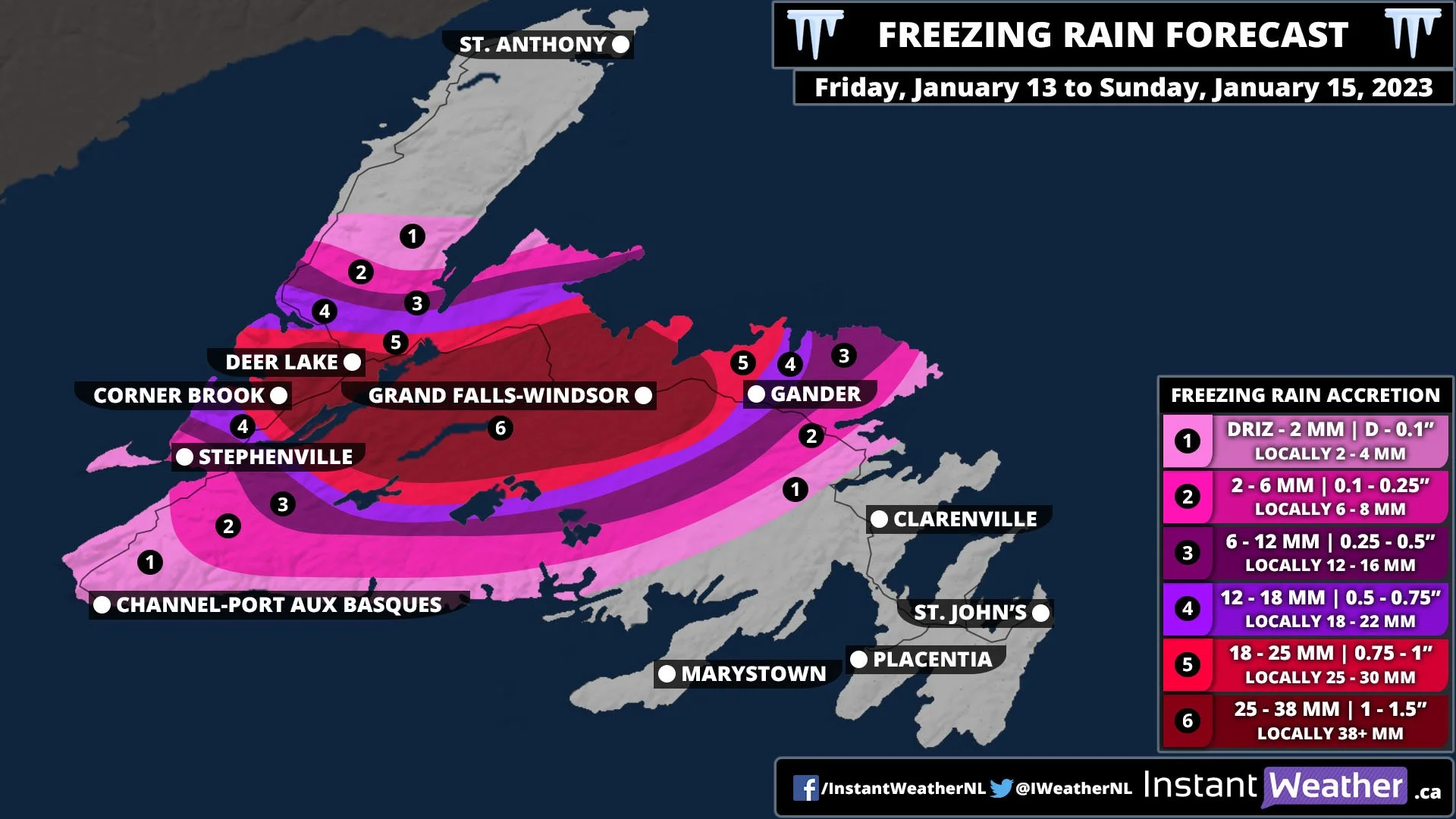
Update: Heavy Freezing Rain Risk Extended Southeast, Eastern Newfoundland Impacts Increased

After reviewing the latest model data, we've updated our freezing rain forecast to reflect a southeast shift in the heaviest precipitation and to include additional freezing rain expected for Monday morning.

Corner Brook and Deer Lake will still get significant ice accretion, but it is a bit less than originally expected. From Gander, through Terra Nova, to Clarenville can now expect to impacted more by the storm.

Typically, 10mm of ice accretion from freezing rain is enough to damage trees and power lines. Beyond that, with 25+mm, we could be looking at extensive damage. Wind gusts appear to remain light through the day tomorrow and into Sunday morning, but will pick up by Sunday afternoon. Gusts will be in the 40-50km/h range and this could trigger additional damage to trees and power lines.

We've already begun to see some light freezing rain around Port aux Basques with the transition from snow to rain and in the early morning hours, there will be a pocket hitting the Corner Brook and Deer Lake area. It will spread south and east through the morning and by mid-afternoon, the heaviest freezing rain will start and it will last into overnight. The freezing rain will continue throughout the day Sunday and into Monday morning, but it will be focused over Central and Eastern Newfoundland, giving Western Newfoundland a reprieve.

Major Winter Storm Will Bring Over 100mm of Rain, Up to 75cm of Snow, and Substantial Amounts of Freezing Rain to Newfoundland This Weekend

Newfoundland is going to be hit by quite the winter storm beginning later this afternoon and continuing straight through to Sunday evening. This storm has a lot of moisture associated with it which will fall as a combination of rain, snow, and freezing rain. The dominant precipitation type will vary depending on location; heavy snow in the Northern Peninsula, mostly rain along the South Coast and Eastern Newfoundland, and freezing rain centrally.

The storm will start with light snow near Port aux Basques around noon today and it will spread northeastward across the Island. After a couple of hours of light snow, heavier snow will move in. By the evening, most of the Island will be seeing snow, with the exception being the Eastern Avalon. It’s at this point that the warmer air will start to push its way across the province, resulting in a transition from rain to snow overnight into Saturday morning. Conditions will start to become messy on Saturday.

The warm air and rain will only extend as far north as the Northern Peninsula, where upwards of 75cm of snow is expected to fall by Sunday evening. Between the snow and rain, there will be a pocket of temperatures that will hover around 0° and freezing rain will fall. This area will shift throughout the day, bringing even light freezing rain to a large swath of Western and Central Newfoundland. A stretch from Corner Brook and Deer Lake to Grand Falls-Windsor will receive heavy freezing rain for the better part of 18 hours tomorrow. This area can expect in excess of 40mm (1.5 inches) of ice accretion.

Overnight Saturday into Sunday, the snow will end in the Northern Peninsula and there will be a brief reprieve in the freezing rain before it re-intensifies late Sunday morning and lasts into the afternoon. Unfortunately, we are not seeing much of a warm-up for the areas hit the hardest by the freezing rain until Tuesday and this level of ice accretion will easily bring down large branches and trees as well as power lines. It is important that if you live in this area, to be prepared for prolonged power outages.

To the South and Southeast, the main story from this storm will be the rain. Most of Southern Newfoundland can expect at least 50mm of rain and there will be an area of up to 100mm expected to fall by Sunday evening. For St. John’s and the Eastern Avalon, 30-50mm will fall.

Messy Winter Storm Takes Aim at Atlantic Canada This Weekend; Bringing Heavy Rain, Snow and Freezing Rain to Nova Scotia

The next several days will be quite messy across Atlantic Canada with a major winter storm bringing rain, freezing rain, and snow to the region beginning tomorrow morning. For Nova Scotia, the big story from this storm will be widespread heavy rain with 30-50mm expected to fall over the next two days.

The storm will start off as snow, beginning in the early hours of Friday in Western Nova Scotia and spreading eastward throughout the morning. The snow will only last for a couple of hours before transitioning to heavy rain. Yarmouth and Shelburne will likely avoid having snow and will rather have rain right from the start of the storm. Overall snow accumulation will be minor across most of the province with up to 10cm expected to fall in Cumberland County the Cape Breton Highlands. Any snow will quickly melt with the following rain and double digit temperatures.

The steady rain will continue into the afternoon and we’re expecting a brief period of clearing before picking back up again in the evening lasting through to Saturday afternoon. Saturday morning is when we’re going to see the heaviest rain to start in the west and it will reach Cape Breton Island by early afternoon. After several hours of this heavy rain, things will begin to clear up in the late afternoon and early evening. Up to 50mm of rain will fall across Nova Scotia by Saturday evening and there could be higher amounts locally.

On Saturday afternoon, the temperatures will be hovering around 0° in Northern Nova Scotia and there is the threat of freezing rain. Untreated surfaces may become icy quite quickly so be cautious when travelling in the area.

The strongest winds from this storm will be felt with the heavy rain tomorrow afternoon. Along coastal areas, wind gusts will be in the 70-80 km/h range while further inland, expect 60-70 km/h. The exception will be Les Suêtes winds which may be up to 100 km/h and possibly higher.

A second round of precipitation will move in from the south overnight Saturday and may bring widespread freezing rain across the province on Sunday. We will provide further updates on that possibility on Saturday.

Winter Storm to Dump Up to 15-25cm of Snow on Eastern Ontario Between Thursday and Friday

UPDATED FORECAST

ISSUED: Thursday, Jan. 12, 2023 (3:00 PM)

NOTE: You can click on the map to open a zoomable image which will be easier to read.


Eastern Ontario continues to be in the bullseye with the highest snowfall totals of this event. However, the latest model data indicates that this system will be weaker than expected and that the overall totals will be lower and more localized to eastern parts of the province.

Based on this change in the data, we have adjusted our forecast by reducing the highest totals from this event down to 15-25cm which encompasses much of the Ottawa Valley. The heaviest snow is still expected to fall during the overnight hours into Friday morning. Snowfall accumulation above 10cm will be mainly found in Eastern Ontario as we have significantly decreased the expected totals around Georgian Bay and Lake Simcoe.

Around 5-10cm of snow is possible from York Region through Peterborough and into Kingston. The Hamilton and Niagara region may also pick up locally near 10cm with lake enhancement off Lake Ontario. Less than 5cm is expected for the rest of Southern Ontario.


ORIGINAL FORECAST

NOTE: You can click on the map to open a zoomable image which will be easier to read.

The start of 2023 has been fairly unnoteworthy when it comes to the weather across Southern Ontario thanks to a mild stretch of temperatures. However, that has come to an end with the arrival of much cooler air this week and a potential winter storm on the horizon over the next few days. We are watching a system expected to affect Southern Ontario starting early Thursday with the risk of freezing rain across Central and Eastern Ontario throughout the day. Later on Thursday, the temperature will drop allowing for the precipitation to transition over to heavy snow. This heavy snow will linger overnight and into Friday which could result in significant accumulation, particularly in parts of Eastern Ontario with up to 25-40cm of snow possible.

The precipitation associated with this system will come in two separate waves starting with the first round of light to moderate precipitation just after midnight tonight. For Southwestern Ontario and the GTA, the main precipitation type will be rain while we see some freezing rain mixing in further north around the Dundalk Highlands and Lake Simcoe. A few hours of icing is possible throughout the morning hours for Orangeville, Barrie, Orillia, Muskoka, Kawartha Lakes and Haliburton. By the late morning, the freezing rain will taper off and either switch over to some wet snow or drizzle as the first round of precipitation moves out. Those in the Ottawa Valley will remain on the cold side of this system and see mainly snow during the early part of Thursday.

Later on Thursday during the afternoon, we will see the second wave of precipitation move into the region starting with the Niagara region and GTA. Moderate to heavy rainfall will be ongoing extending into the evening in this area as the system tracks to the northeast. By the evening, the upper edge of the precipitation will reach Eastern Ontario and clash with the colder air. As a result, there is the potential for some freezing rain during the evening throughout the Ottawa Valley.

Overnight the colder air will become more entrenched throughout Central and Eastern Ontario allowing for precipitation to transition over to heavy snow after the midnight hour. The most intense snowfall rates will be found just west of Ottawa over the Pembroke and Renfrew region. All areas of Southern Ontario will see some snow during the morning on Friday once the switchover occurs but we expect less snow further to the west where less moisture is present. Lake enhancement off Georgian Bay and Lake Ontario could result in locally higher totals in the Collingwood and Hamilton regions.

All precipitation will come to an end by Friday evening as the system moves out of the region.


Here is an advertisement so we can pay the bills:


NOTE: You can click on the map to open a zoomable image which will be easier to read.

The overall impacts of the freezing rain are expected to be fairly minor due to the limited timeframe and precipitation intensity. We are looking at total ice accretion up to 2mm extending from the Dundalk Highlands and through Central and Eastern Ontario (away from the Lake Ontario shoreline).

Our main focus with this winter storm will be on the potential significant snowfall totals that parts of the Ottawa Valley could pick up by the end of Friday. Current indications suggest the total accumulation will range from 25-40cm for the Renfrew and Pembroke regions. Slightly lower totals are expected throughout the rest of the Ottawa Valley including the city itself picking up around 15-25cm of snow.

For other parts of Eastern Ontario and much of Central Ontario, snowfall totals will approach somewhere between 10 to 20cm although there is some uncertainty due to the extent of the moisture further west. It’s possible some areas around Georgian Bay and Northeastern Ontario could struggle to reach 10cm in total accumulation.

Regions around the Golden Horseshoe will see a general 5-10cm of accumulation, but we could see locally higher totals along the southern Lake Ontario shoreline around Hamilton due to lake enhancement pushing totals close to 15cm. Less than 5cm is expected in Southwestern Ontario where rain will be the main story.


Here is another advertisement so we can pay the bills:

Midweek System to Bring a Wintery Mix to Parts of Southern Ontario With Prolonged Freezing Rain and Heavy Snowfall

updated fORECAST

Issued: Wednesday, January 4, 2023 - 1:30 PM

NOTE: You can click on the map to open a zoomable image which will be easier to read.

Based on the latest model data, there has been a shift in the location of the heaviest freezing rain due to the cold air not making it as far south as initially expected. We have updated our forecast to reflect these latest trends in the models.

This now puts the Ottawa Valley and northern parts of Central Ontario in the bullseye for the heaviest freezing rain accretion. The expected impact for the Kawartha Lakes and Kingston region will be lower as they will see more rain instead of prolonged freezing rain.

In addition to the shift in freezing rain risk, we have bumped up the expected ice accretion from 6-12mm to 8-16mm in the hardest-hit regions. This amount of ice is approaching the threshold that we would consider to be significant. However, the limited timeframe of 12-16 hours with freezing rain should limit the worst impacts compared to a more prolonged event. Power outages and icy road conditions will still be a big concern throughout the day and especially into the overnight hours when the freezing rain will be the most intense.

For those further north including Sudbury and North Bay, the story will be a mix of snow and ice pellets. And the rest of Southern Ontario will see between 15-30mm of rain by the end of Thursday.


PREVIOUS fORECAST

NOTE: You can click on the map to open a zoomable image which will be easier to read.

The rollercoaster of a season that has been this winter across Southern Ontario continues after the brief taste of weather we normally see in late fall or early spring rather than in January. This will come in the form of a messy winter system moving across our region over the next few days. Depending on the location, we could be looking at a fairly prolonged period of freezing rain late Wednesday into early Thursday morning for Central and Eastern Ontario. Further north, the story will be a mix of ice pellets and heavy snow with up to 10-25cm of total accumulation.

The impacts from this system will be less of a concern for Southwestern Ontario and the GTA where temperatures will stay above the freezing mark and keep the predominant precipitation type as rain. With rainfall totals ranging from 10 to 25mm, it could pose an issue in areas prone to flooding with the ground being partially frozen and unable to absorb a lot of moisture. This is especially true with all the rainfall that these areas have already received in the past week. There could even be the risk of an isolated non-severe thunderstorm towards the Lake Huron shoreline this evening.

Precipitation in the form of rain is already ongoing throughout the region as of Tuesday afternoon. As temperatures slowly drop late in the evening and overnight, we will see some areas transition over to freezing rain starting with the higher elevations of the Dundalk Highlands and over Algonquin Park. For the overnight and into Wednesday morning, the wintery precipitation will be primarily contained to those regions.

By the afternoon on Wednesday, the below-freezing temperatures will clash with the system over Eastern Ontario leading to the development of an expansive and heavy band of freezing rain. This will start with the Bancroft and Ottawa Valley area during the afternoon and expand southward towards the Kawartha Lakes and Kingston region by late Wednesday. Those on the northern edge of the freezing rain including Algonquin Park, Bancroft and Ottawa will see some ice pellets and wet snow mixing in with the freezing rain by the evening.

The heaviest freezing rain is expected to occur during the overnight hours on Wednesday and early Thursday morning through Peterborough and Kingston along with the Orangeville region. Precipitation will slowly come to an end by the late morning hours on Thursday as the system moves out of the province.


NOTE: You can click on the map to open a zoomable image which will be easier to read.

Here is an advertisement so we can pay other bills:


In terms of the overall impact of this system, it will likely be from the prolonged freezing rain in locations such as Shelburne, Orangeville, Peterborough, Tweed, Kingston and Brockville. Total ice accretion here will range from 6-12mm in the hardest hit regions although some ice pellets mixing in along the northern edge could reduce the actual accumulation. This amount of ice could lead to icy road conditions along with localized power outages and tree damage. Kingston and Brockville in particular could see the worst impact from the freezing rain with some models pointing to upwards of 15mm of ice accretion.

As you go further north, the focus will shift to ice pellets and heavy snow throughout Muskoka, Algonquin Park and the Ottawa Valley. Total accumulation will be hard to measure in this area due to the mix of precipitation but it certainly could cause some poor road conditions. Accumulating snow is possible for Northeastern Ontario with between 10-25cm of snow.

Those regions just to the north of the GTA around Lake Simcoe and into the northern shoreline of Lake Ontario could see some brief freezing rain with 2-6mm of ice accretion. The rest of Southern Ontario will stay on the warm side of this system seeing rainfall totals between 10-25mm.

Blizzard Continues in Parts of Southern Ontario Through Christmas Eve With Up to an Additional 50cm of Snow

NOTE: You can click on the map to open a zoomable image which will be easier to read.

'Twas the night before Christmas, when all through the house
Not a creature was stirring, not even a mouse;
because they have been buried in the snow…

It certainly has been an eventful start to the holidays across Southern Ontario after a major winter storm brought much of the region to a standstill over the past 48 hours. From flash freeze and heavy snow to damaging wind gusts, we’ve seen everything from this storm that continues to hammer parts of the traditional snowbelt with crippling blizzard conditions. These conditions have resulted in many road closures in the hardest-hit areas and emergency officials are asking people to stay off the road.

We are now approaching the night before the big day and the snow squalls that have buried regions east of Lake Huron and Georgian Bay along with the Niagara and Kingston regions refuse to let up. The relentless snow squall activity will continue to lead to rapid snowfall accumulation for the areas that have already been hardest hit. Parts of Grey, Bruce, Huron and Perth counties east of Lake Huron in addition to Muskoka east of Georgian Bay have seen snow drifts approach 100cm. And as the snow squalls continue overnight into Christmas morning, we expect to see an additional 25-50cm of snow on top of what has already been received. Meaning that the final snowfall totals for this weekend could be well over 100cm in some areas!

Overnight we do expect to see somewhat of a break for regions to the northeast and east of the lakes with the snow squalls drifting southward by morning. This will bring the snow squall threat down into regions southeast of Lake Huron and Georgian Bay including northern Simcoe County and Kawartha Lakes. The lake effect snow off Lake Erie and Lake Ontario should shift south of the border after pummeling the Fort Erie and Prince Edward County regions. Squalls will continue throughout Sunday with this primarily northwesterly flow although they may drift back north towards the end of the day. It looks like the snow squalls will remain ongoing into Monday although the exact locations impacted is unclear.


NOTE: You can click on the map to open a zoomable image which will be easier to read.


Here is an advertisement so we can pay the bills:


As we have seen so far with this storm, the snowfall accumulation will be intense but very localized so not everyone will experience the ‘crippling’ conditions. And some locations that have yet to see these conditions are expected to have conditions worsen later tonight so don’t let your guard down just yet!

The highest totals still to come will extend from the Bruce Peninsula through Southern Muskoka and Northern Simcoe County where we are looking at an additional 30-50cm of snow by the end of Monday. Some localized pockets may even exceed 50cm and come close to 75cm depending on where the squall sets up and how long it locks in place.

A more widespread region will pick up around an additional 20-40cm of snow which includes the rest of Muskoka, Kawartha Lakes and regions east of Lake Huron. The K/W region along with Barrie and Peterborough is right on the bubble and could go either way so we’ve gone with a 10-25cm range here due to the low confidence in how far inland these squalls will make it. The accumulation gradient will be quite tight so surrounding regions will see little in terms of snowfall ranging from 5-15cm.


NOTE: You can click on the map to open a zoomable image which will be easier to read.

The snow squall activity to the east through the Niagara and Kingston regions will be primarily a story for just this evening with bands shifting southward overnight. Regardless, we are expecting quite a heavy dumping of snow still ahead for Fort Erie and Prince Edward County seeing an additional 20-40cm (likely towards the lower end of this range). Port Colborne and Kingston will see around 10-25cm of more snowfall by the end of the weekend. And the surrounding locations including Welland, Belleville and Brockville will get 5-15cm of additional accumulation.

On behalf of the entire Instant Weather team, we would like to wish everyone a safe and happy holiday weekend!


Here is another advertisement so we can pay other bills:

‘Crippling’ Blizzard to Put a Damper on the Holiday Weekend in Parts of Southern Ontario With Up to 100cm of Snow Possible

NOTE: You can click on the map to open a zoomable image which will be easier to read.

As we approach the final days before Christmas, Mother Nature is set to deliver what has the potential to be a crippling blizzard for parts of Southern Ontario over the next few days. In addition to the blizzard risk in the traditional snowbelt, there is also the threat of strong wind gusts, a flash freeze and significantly colder temperatures. All these threats will combine to amplify this winter storm into a very serious situation across Southern Ontario. This has prompted Environment Canada to issue a blizzard warning mentioning the risk of a ‘Crippling’ blizzard and that ‘Travel will become dangerous and is not advised’.

The effects of this system have already started to be felt with a mix of rain, freezing rain and snow depending on your location. Precipitation will continue to build overnight and into Friday morning with temperatures hovering around the freezing mark. With rain ongoing throughout the morning, temperatures will start to plunge starting with Deep Southwestern Ontario just after midnight and reaching the GTA by late morning. Those in Eastern Ontario will see a switch over to regular rain as temperatures temporarily rise during the morning, but the temperature plunge will happen by the early afternoon.

While this normally wouldn’t be a big issue, the previous rainfall combined with the rapidly dropping temperature will cause the rain to turn to ice. Especially with how quickly the temperature will drop leaving little time for road crews to deal with the icy conditions. For example, Toronto will be around 4°C at 8 am, 2°C at 10 am, -5 at 12 pm and -8 by 2 pm. Over 12 degrees in temperature drop within 6 hours! Please exercise extreme caution out on the roads as black ice can be hard to spot. Stay home if possible or until several hours after the freeze to give time for road crews to clean up the roads.


NOTE: You can click on the map to open a zoomable image which will be easier to read.


Here is an advertisement so we can pay the bills:


The other component of this complex storm will be the strong wind gusts developing as the system rapidly intensifies over the region. Based on the latest data there has been a slight decrease in the expected wind gusts, but we are still expecting a damaging wind storm. Winds will begin to pick up through the early afternoon hours and continue for the rest of the day and into the evening.

We expect the strongest wind gusts will be found in the Niagara region just off the northeastern shoreline of Lake Erie where gusts could approach or even exceed 110km/h. This is especially the case directly along the shoreline in locations like Port Colborne and Fort Erie. Outside of this area, strong wind gusts ranging from 80-100km/h will be a threat throughout Southwestern Ontario, the GTA and into Eastern Ontario. The strongest gusts will be found directly along the shorelines of Lake Huron, Lake Ontario and along the Dundalk Highlands where the 100km/h gusts are more likely while further inland will be closer to 80-90km/h.

With wind gusts this intense, we will likely see widespread power outages which may last for a prolonged period. The heavy snowfall accumulation and icy conditions will make it difficult for hydro crews to effectively restore power to everyone so it may take some time. Another danger would be the frigid temperatures expected over the weekend with the wind chill making it feel into the -20s by Saturday morning. Anyone without power could struggle to stay warm so be sure to have a plan in place should that occur.

These strong wind gusts will also pose a problem with the lake effect snow expected to develop on Friday resulting in widespread blizzard conditions in areas east of Lake Huron and Georgian Bay along with the Niagara region. Travel in those regions will likely become near impossible with highways closures almost certain due to reduced visibility and plows being unable to keep up with the intense snowfall rates. All travel should be avoided here until conditions improve as you don’t want to be stranded out in your vehicle with bitterly cold temperatures.


NOTE: You can click on the map to open a zoomable image which will be easier to read.

Back to the snowfall story which could be quite serious for those that are impacted by snow squall activity over the weekend. With cold air firmly in place, the system stalled out and rotating over the region will be enhanced by some locally heavy lake effect bands of snow starting Friday afternoon. It appears that it will be primarily a westerly flow which means the lake effect snow will really focus on the Grey-Bruce region along with those in Muskoka and Parry Sound.

The system-related snowfall will begin to taper off overnight Friday, but the lake effect snow will continue and could even further intensify. Current model guidance suggests that a very prolific snow squall will set up across the Bruce Peninsula, going over Georgian Bay and coming back inland through around Port Carling and Bracebridge. The snow squall may remain locked in through that general region all the way through Saturday and into Sunday. While this will limit the impact to a smaller region, it will mean those who do see it is going to be pummeled by intense snowfall amounts.

Lake effect snow and localized snow squalls will also be ongoing east of Lake Huron. It currently appears that the lake effect snow here will come in the form of multiple weaker bands instead of one main intense squall. This doesn’t mean the impact will be less, in fact, it could be just as bad with stronger wind gusts expected in this area. And the overall impact will be more widespread rather than contained in one small zone as is the case east of Georgian Bay.

Snow squall activity will continue into Sunday with similar locations being impacted. In terms of accumulation, the ‘winner’ (if you can call it that) by the end of the weekend appears to be somewhere in the Muskoka region where data continue to point towards upwards of 100cm over the next 3 days. Now, this will be very focused and not the entire region will see crazy totals like this. But we believe somewhere within that area will pick up that much.

Those east of Lake Huron can expect around 50-75cm (maybe up to 100cm in some spots) of snow with lower amounts further inland. Important to note that the snowfall is spread throughout several days so accumulation over any given 24 hour period will max out at around 20-40cm.

Here is another advertisement so we can pay other bills:


NOTE: You can click on the map to open a zoomable image which will be easier to read.


The other location set to receive a blast of snow is the southeastern tip of the Niagara region. This is thanks to a strong snow squall setting up Friday afternoon and continuing throughout the weekend. There is still some uncertainty on the extent of how much impact it will have on our side of the border. As this band will also bury Buffalo (for the second time this year) and the most intense parts could remain south of the border. Regardless those in Port Colborne and Fort Erie will likely see anywhere from 40-75cm with maybe as much as 100cm, particularly for the Fort Erie area.

Outside of the snowbelts, we are looking at 25-50cm of snow throughout Central and Eastern Ontario which will remain on the cold side of this system for the most part. Slightly lower totals are expected for Deep Southwestern Ontario and Northern GTA ranging from 15-30cm. And finally, the GTA including Hamilton, Toronto and right along the Lake Ontario shoreline should escape the worst when it comes to snowfall. We are currently looking at around 5-15cm by the end of the weekend for them.

For Christmas Day, the weather shouldn’t be that bad unless you are in the aforementioned areas receiving snow squall activity. However, roads could still be quite messy with ice and snow so be sure to drive according to the conditions if you must travel. Looking into next week, we see the risk of more lake-effect snow which we will be closely watching.

Please stay safe and stay home if you can!


Here is another advertisement so we can pay other bills:

Potentially Historic ‘Nightmare Before Christmas’ Storm Threatens to Ruin Holiday Plans Across Southern Ontario

NOTE: You can click on the map to open a zoomable image which will be easier to read.

We are watching what could be a life-threatening winter storm for Southern Ontario in the days before Christmas. You might be rolling your eyes reading this and thinking 'Oh yeah, another storm where we'll barely get anything'. And your skepticism is warranted as it has been quite a long time since we've experienced a storm of this scale.

However, it's important to emphasize that the particular dynamics of this upcoming storm are very concerning with the combined threat of a flash freeze, rapid drop in temperatures, destructive wind gusts and blizzard conditions. While there is still time for models to change, the confidence in this storm is quite high and you should be getting prepared now. We don't take a forecast like this lightly as it can cause a lot of stress, but it's a lot better to be prepared for the worst rather than being caught off guard.

The uniqueness of this storm has made us rethink our usual approach to forecasting a winter storm as the danger from this event isn't focused on one particular threat type (like heavy snow, wind or freezing rain). The concern is how the different threats will combine and help to maximize their impact on our region over the next few days. So we've decided to start our preliminary forecast with a regional look at the impact of this winter storm including the expected conditions on each day. We know many are trying to plan their holiday travel and that the timing of this event is what matters the most.

We have put together maps and forecast discussions for each region throughout Southern Ontario. We will still have our regular forecast maps including snowfall totals and maximum wind gusts, but the purpose of this is to provide a more holistic view of the impacts over the several days. Our full forecast will be released sometime late Wednesday or early Thursday.


IMPORTANT: There has been some confusion regarding the regional map. To clarify, the graphic on the right of each regional forecast is unrelated to the map. We have chosen to break down the impact and threat type by each day and went into detail about timing. The map shows the overall impact of this storm. We understand that using the same colour on the graphic and the map resulted in this confusion and we will be fixing it for future forecasts.


NOTE: You can click on the map to open a zoomable image which will be easier to read.


Here is an advertisement so we can pay the bills:


For Southwestern Ontario, Thursday will start as the calm before the storm with temperatures near the freezing mark as you wake up in the morning. By the afternoon, temperatures will slowly rise into the low single digits along with some light rain moving into the region later in the afternoon. This rain will set the stage for our first hazard associated with this multi-day event when combined with an expected rapid temperature drop just after midnight and into Friday morning.

Temperatures will drop by 10-15 degrees in the span of a few hours resulting in a flash freeze throughout the region. Roads will likely become quite icy during the predawn hours on Friday. In addition to this, the rain will transition over to snow with more intense bands east of Lake Huron due to some lake enhancement of the system snowfall.

As the heavy snow continues with a particular focus on areas east of Lake Huron, the system will stall out over our region and rapidly intensify. This intensification will result in the development of some strong to damaging wind gusts ranging from 90-110km/h inland and even stronger directly along the shoreline.

Friday afternoon and evening are when we expect the worst conditions with gusty winds combined with heavy snow leading to blizzard conditions. Highway closures are almost certain and any non-essential travel should be avoided late Friday. The strong wind gusts will likely result in widespread power outages and make for a very dangerous situation with one of the coldest nights of the season so far on Friday. It will feel like into the -20s once you factor in the brisk wind chill. It's VERY important that you don't venture out in these conditions as when (not if) you get stranded in your vehicle, it will probably be a long time until emergency officials can get to you.

Snow squall activity will continue east of Lake Huron throughout Saturday and into early Sunday. This will likely lead to snowfall accumulation of over 50cm between Friday and Sunday for the Grey-Bruce region. The rest of Southwestern Ontario can expect around 15-30cm of snow by the end of the weekend. We hope that the power outages can be limited because Saturday and Sunday night appears to be just as cold making for one of the coldest Christmas in recent memory.


NOTE: You can click on the map to open a zoomable image which will be easier to read.

Temperatures will start on a mild note throughout the GTA on Thursday as warm air flows in advance of the approaching system. Daytime highs are expected to approach the mid-single digits as the rain starts to move in by late Thursday afternoon. The mild air will hold on throughout the evening and overnight with heavy rainfall. Total rainfall accumulation of up to 10-20mm is possible by Friday morning. Temperatures are expected to take a plunge by the late morning and early afternoon dropping over 5-10 degrees in a few hours. With the ground still wet from the previous rainfall, there is a strong flash freeze risk as roads will become quite icy.

Rain will turn over to snow by Friday afternoon across the Golden Horseshoe as we see the increase in wind gusts later in the day. Damaging wind gusts approaching 90-110km/h (higher in the Niagara region off Lake Erie) are expected during the evening and overnight hours. Power outages are possible in the hardest hit regions along with poor driving conditions due to blowing snow and even localized blizzard conditions in the Niagara region.

Snow squalls will also develop off Lake Erie and further enhance the system snowfall for the Niagara region. The heaviest snowfall rates will be found right along the Lake Erie shoreline including Port Colborne and Fort Erie. Lake effect snow activity will continue throughout the day on Saturday and into Sunday while the system-related snowfall will taper off for the rest of the GTA by early Saturday.

Current data suggests that much of the GTA could end up in a dry pocket when it comes to snowfall accumulation. At this point, most of the GTA will see around 5-15cm of snow over the weekend. The only exception is the Niagara region which will see snow squalls pushing totals into the 20-40cm range over the weekend. Localized spots right along the Lake Erie shoreline may even pick up more than that!

The main danger from this storm in the Golden Horseshoe will be the flash freeze risk on Friday late morning along with damaging wind gusts. Those who lose power from the wind damage could stay in the dark for an extended period due to the widespread impact expected. This isn't a good situation with the wind chill making it feel into the -20s over the weekend so be sure to have a plan in place to stay warm! And of course, the Niagara region will be heavily impacted by the snow squalls burying them in lots of snow along with blizzard conditions. Travel should be avoided in this region until conditions improve.

Here is another advertisement so we can pay other bills:


NOTE: You can click on the map to open a zoomable image which will be easier to read.


NOTE: You can click on the map to open a zoomable image which will be easier to read.


The forecast for Central and Eastern Ontario is quite complex as it will start on Thursday with temperatures slightly below the freezing mark. Temperatures will only rise to near the freezing mark during the afternoon as light snowfall approaches the region later in the day. Those along the Lake Ontario shoreline are expected to be slightly warmer which will allow them to see light rain instead of snow. Snow (rain near the Lake Ontario shoreline) will continue to intensify throughout the evening and overnight on Thursday.

By Friday morning, there could be a brief warm-up throughout Central and Eastern Ontario allowing for the snow to switch over to rain for a few hours. Temperatures are expected to plunge well below the freezing mark later in the day as colder air floods into the region. As a result, there is the risk of a flash freeze especially around the Lake Ontario shoreline with a lot more rain on surfaces to freeze up. Expect icy road conditions during the afternoon as the temperature quickly drops which will also transition the precipitation back over to snow.

The worst conditions are expected late Friday into Saturday as the low-pressure system rapidly intensifies as it stalls out over the region. Lake-enhanced snowfall east of Georgian Bay and northeast of Lake Ontario will be the main focus with intense snowfall rates and blizzard conditions as wind gusts strengthen early Saturday. Regions including Muskoka, Parry Sound, Kingston and Prince Edward County will bear the brunt of this system with a focused snow squall developing off both Georgian Bay and Lake Ontario. Expect dangerous travel conditions throughout the hardest hit region during the morning and afternoon on Saturday. Avoid all non-essential if you can.

Wind gusts will also be an issue in this part of Southern Ontario but to a lesser extent. The only area expected to see near damaging wind gusts is along the Lake Ontario shoreline with gusts approaching 90-100km/h. Otherwise, wind gusts will range from 60-80km/h for the rest of Central and Eastern Ontario.

Snow squalls and very dangerous conditions will continue east of Georgian Bay throughout Saturday and into Christmas Day on Sunday. If you are in the affected regions, you should make plans to not travel on Christmas Day as roads in this area will likely be impassible due to the extensive amount of snowfall over the last few days.


Here is another advertisement so we can pay other bills: