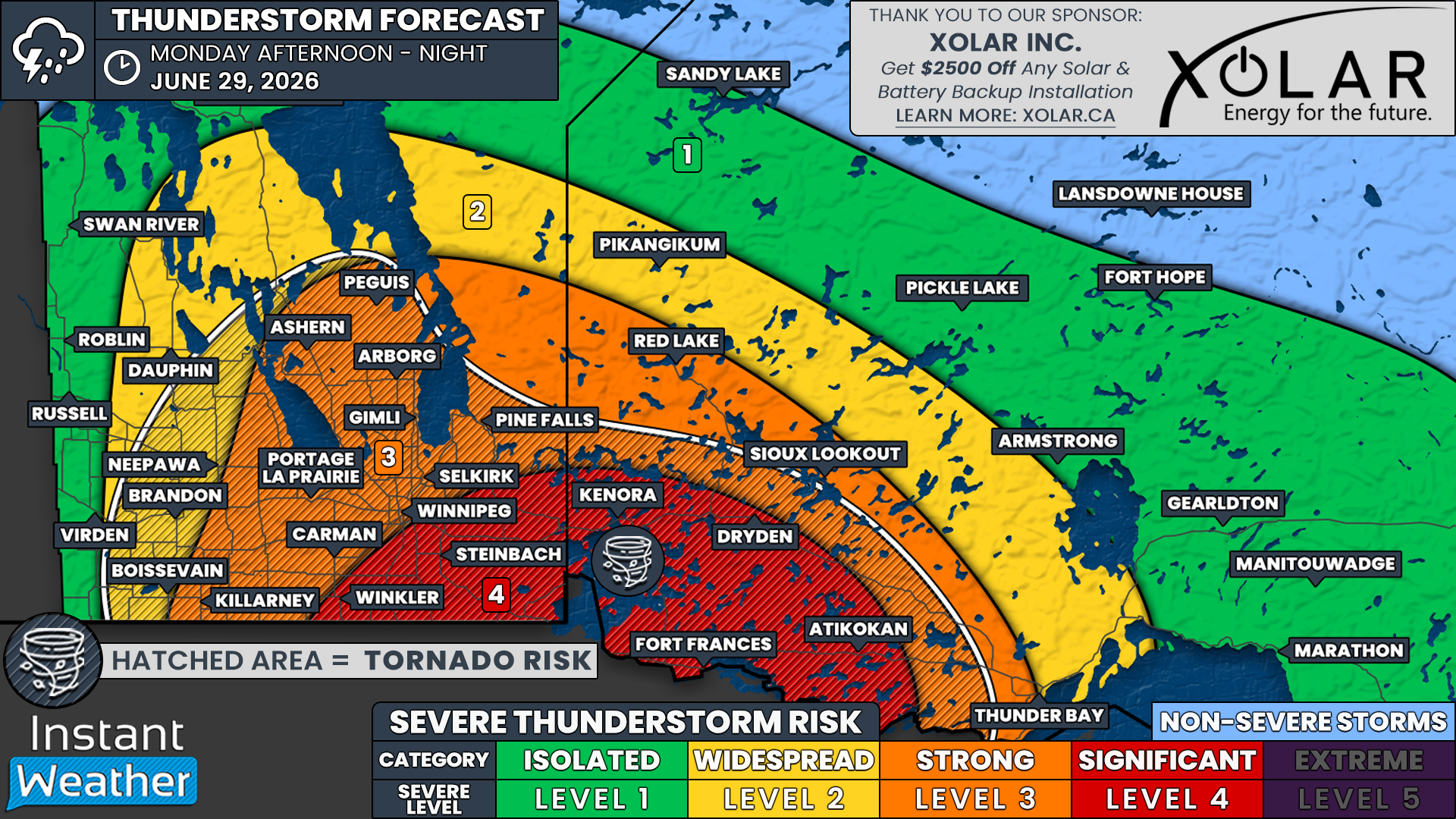
Multiple Tornadoes and Tennis Ball Sized Hail Possible Monday Across Manitoba and Northwestern Ontario
/
NOTE: YOU CAN CLICK ON THE MAP TO OPEN A ZOOMABLE IMAGE
After a destructive severe weather outbreak that brought violent tornadoes to Western Manitoba on Sunday, the risk shifts eastward into Winnipeg, Eastern Manitoba and Northwestern Ontario on Monday.
Based on the latest forecast data, today's storms could bring a similarly dangerous setup with the potential for significant severe weather, including multiple tornadoes, huge hail up to the size of tennis balls, destructive wind gusts in excess of 100 km/h, and areas of flash flooding.
The greatest concern is across areas just southeast of Winnipeg where we have issued a 'significant' severe weather risk. This includes Winkler, Steinbach, Kenora, Dryden, Atikokan and Fort Frances.
Storms that develop in this corridor will have the potential to rapidly become powerful supercells capable of producing all severe weather hazards. The tornado threat is expected to be highest in this zone where atmospheric conditions appear most favourable for rotating thunderstorms.
A 'strong' severe weather risk extends across the rest of South-central and Eastern Manitoba, including Winnipeg, Portage la Prairie, Carman, Killarney, Selkirk, Gimli, Ashern, Arborg, Peguis, Pine Falls, Red Lake, Sioux Lookout and Thunder Bay.
While damaging wind gusts and large hail will likely be the primary hazards across much of this area, an isolated tornado cannot be ruled out, especially across South-central Manitoba and the Interlake region where conditions may still support discrete rotating storms before they begin to organize into larger clusters.
Farther west, there is a widespread to isolated severe weather risk across Western Manitoba, including Brandon, Virden, Dauphin, Roblin and Swan River. Flooding is expected to be the biggest concern in this region as slow-moving thunderstorms could repeatedly track over the same communities.
Rainfall totals could exceed 100 mm in localized areas, leading to flash flooding. An isolated tornado also cannot be ruled out around the Brandon area during the afternoon should any storms remain isolated long enough to become organized.
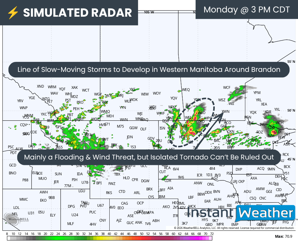
SIMULATED RADAR - MAP FROM WEATHERBELL
Today's severe weather threat is expected to begin during the afternoon with slow-moving thunderstorms developing across Western Manitoba, particularly near the Brandon area.
These storms will move very little, increasing the risk of training thunderstorms where multiple storms repeatedly pass over the same locations.
This could quickly lead to localized flooding, but these storms may also be capable of producing large hail, damaging wind gusts and even an isolated tornado.
SIMULATED RADAR - MAP FROM WEATHERBELL
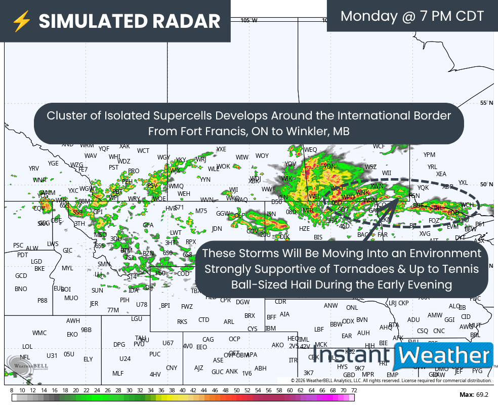
The primary severe weather outbreak is expected to unfold later in the afternoon and into the early evening as isolated thunderstorms develop along the international border from Winkler eastward through Southeastern Manitoba and into Fort Frances in Northwestern Ontario.
The atmosphere during this period is expected to be highly supportive of supercell development. Any storm that can remain isolated will have the potential to produce tornadoes, very large hail and destructive wind gusts.
Hail could reach the size of tennis balls in the strongest storms, which would be capable of causing significant damage to vehicles, roofs and crops.
Winnipeg sits near the northwestern edge of the greatest severe weather threat. While current guidance keeps the most dangerous storms just southeast of the city, even a small shift farther west could bring a much higher tornado risk into the Winnipeg area.
SIMULATED RADAR - MAP FROM WEATHERBELL

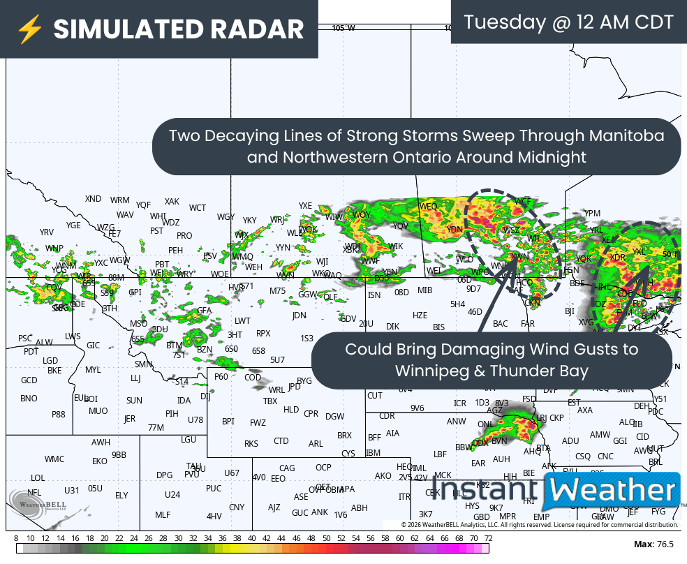
The tornado threat should gradually decrease after sunset as daytime heating fades and the atmosphere becomes less favourable for discrete supercells. However, that will not mark the end of the severe weather threat.
As the evening progresses, many of the isolated storms are expected to merge into one or more organized lines of thunderstorms. While the tornado risk will lessen, these storm lines could produce widespread destructive wind gusts capable of causing tree damage, power outages and structural damage across parts of Manitoba and Northwestern Ontario.
These storms could reach the Winnipeg and Thunder Bay regions around midnight with another round of severe weather. Although the primary concern overnight will shift toward damaging straight-line winds, an isolated nocturnal tornado cannot be completely ruled out.
The severe weather threat should come to an end across Manitoba after midnight as the storm complex moves eastward. However, portions of Northwestern Ontario may continue to see strong to severe thunderstorms into Tuesday morning before the system gradually weakens and exits the region.