Southern Ontario Faces Severe Storm and Tornado Risk Thursday Ahead of Possible Canada Day Heatwave
/THIS FORECAST IS SPONSORED BY:
NOTE: YOU CAN CLICK ON THE MAP TO OPEN A ZOOMABLE IMAGE
While the latter half of June has been relatively quiet across Southern Ontario when it comes to severe weather, thanks to cooler temperatures dominating the region, that pattern is about to change in a big way. As we head into the final days of June, much warmer and increasingly humid air will begin pushing into the province, bringing with it a rapidly increasing risk for thunderstorms.
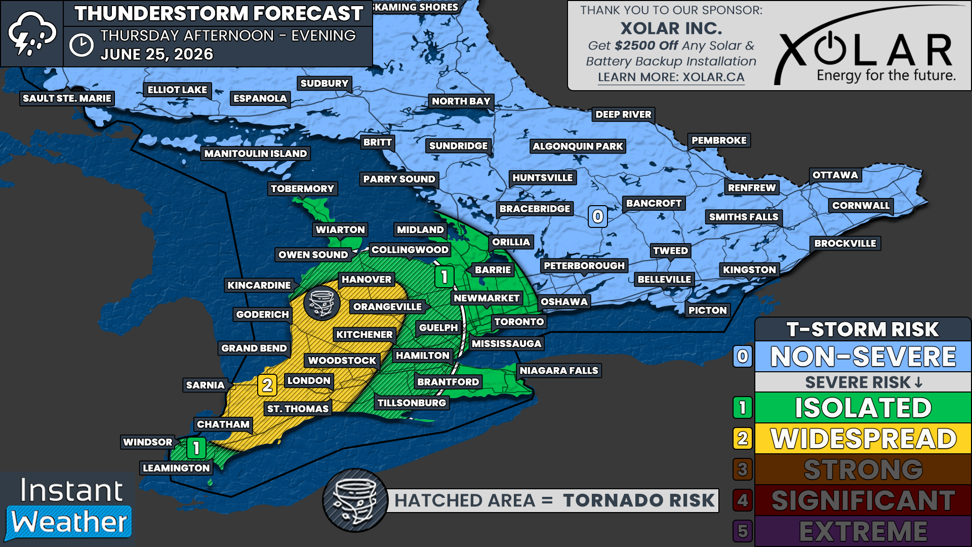
The first significant opportunity arrives on Thursday, when portions of Southwestern Ontario could see a widespread severe thunderstorm risk. An isolated severe threat may also extend farther east into parts of the Golden Horseshoe and Central Ontario.
If thunderstorms are able to develop during the afternoon and early evening, they will move into a very favourable environment capable of supporting supercell thunderstorms. These storms could produce all modes of severe weather, including toonie-sized hail or larger, damaging wind gusts in excess of 100 km/h, torrential rainfall and even a few isolated tornadoes.
The most favourable environment currently appears to be across areas including Sarnia, Chatham, Grand Bend, Goderich and London. However, isolated thunderstorms could also develop as far north as the Bruce Peninsula, east toward Lake Simcoe, and south into portions of the Greater Toronto Area. While the tornado threat decreases farther away from Lake Huron, it cannot be completely ruled out as far east as Kitchener, Hamilton and portions of the southern Georgian Bay shoreline.
Join Us on YouTube for Storm Coverage:
We'll be providing comprehensive live coverage of any storms that develop on Thursday afternoon on our YouTube channel. Our team will be tracking storms in real time with live radar analysis, warnings, storm reports and chaser coverage, so if severe weather threatens your area, be sure to join us live to help stay informed.
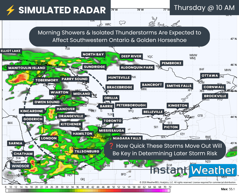
SIMULATED RADAR - MAP FROM WEATHERBELL
Thursday's forecast does come with one important complication. Morning showers and non-severe thunderstorms are expected to move through Southwestern Ontario before spreading into Central and Eastern Ontario during the day.
As we've seen many times before, morning convection can make or break an afternoon severe weather event. If clouds and showers linger too long, they can prevent the atmosphere from recovering enough to support stronger storms later in the day.
On the other hand, if skies clear by around the noon hour, as many of the latest models suggest, there should be several hours available for temperatures and instability to quickly rebound.
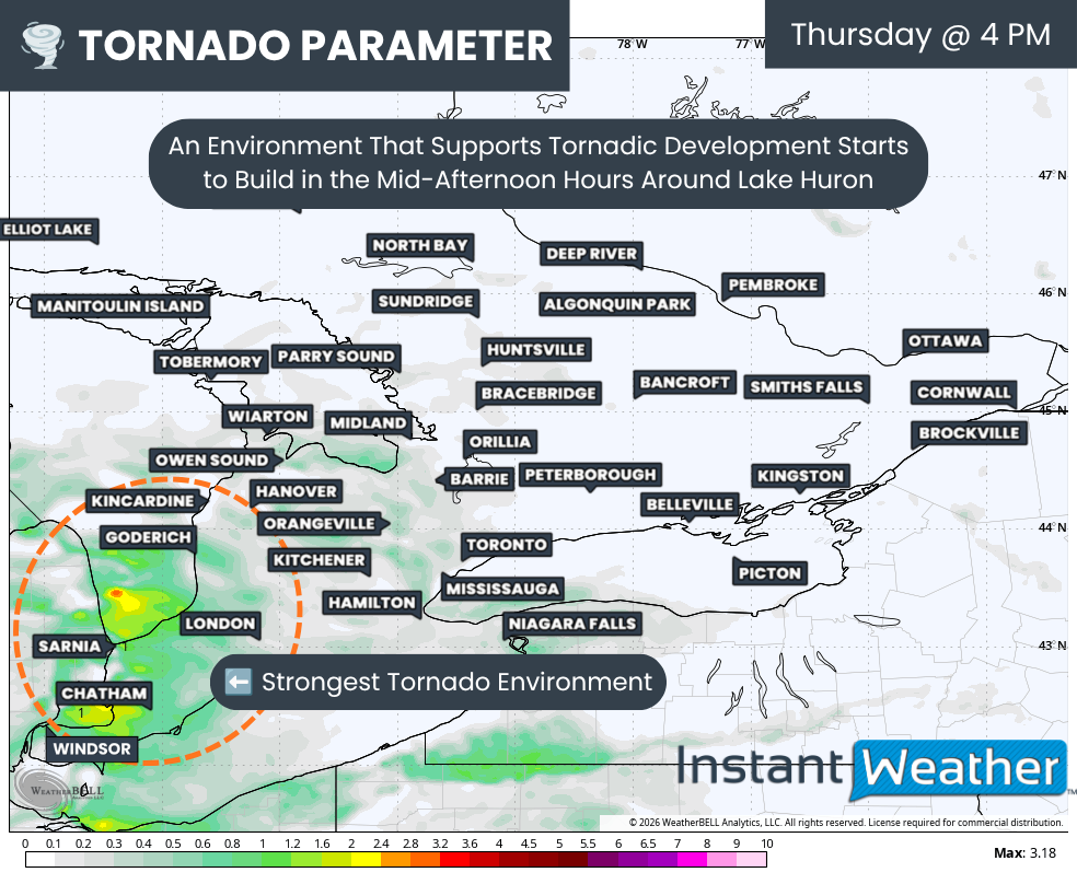
Significant Tornado Parameter - MAP FROM WEATHERBELL
By the mid-afternoon, the atmosphere is expected to become increasingly supportive of severe thunderstorms, with the highest risk developing between roughly 2 PM and 6 PM. The strongest combination of instability and wind shear currently appears to be centred near the Lake Huron shoreline, extending into Sarnia and Chatham.
The latest Significant Tornado Parameter (STP) data also highlights an enhanced corridor stretching from the Michigan border across Lake Huron into Southwestern Ontario. Should storms form within this corridor, they could rapidly intensify into rotating supercells capable of producing very large hail, damaging winds and isolated tornadoes.
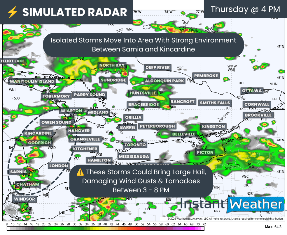
SIMULATED RADAR - MAP FROM WEATHERBELL
THIS FORECAST IS SPONSORED BY:
There remains some disagreement among the forecast models regarding exactly where storms will first develop.
Some models initiates storms as early as 3 PM across Michigan before they quickly cross into Deep Southwestern Ontario. This scenario would place communities such as Sarnia, Grand Bend, Goderich and London at the greatest risk.
Other models delay development until later in the afternoon or early evening, with storms forming closer to the Hanover to Grand Bend corridor before tracking southeast toward London, Kitchener and possibly Hamilton. Regardless of which solution verifies, the greatest tornado potential continues to favour areas along and just inland from the southeastern Lake Huron shoreline.
Additional isolated thunderstorms may also develop around Lake Simcoe and into the Greater Toronto Area during the late afternoon and early evening. While the environment in these areas appears less favourable for widespread severe weather, a few stronger storms cannot be ruled out. The primary threats would be hail up to quarter size along with isolated damaging wind gusts.
As the sun sets Thursday evening, the severe weather threat should gradually diminish as daytime heating is lost. However, scattered non-severe showers and thunderstorms may continue well into the overnight hours, particularly across Central and Eastern Ontario.
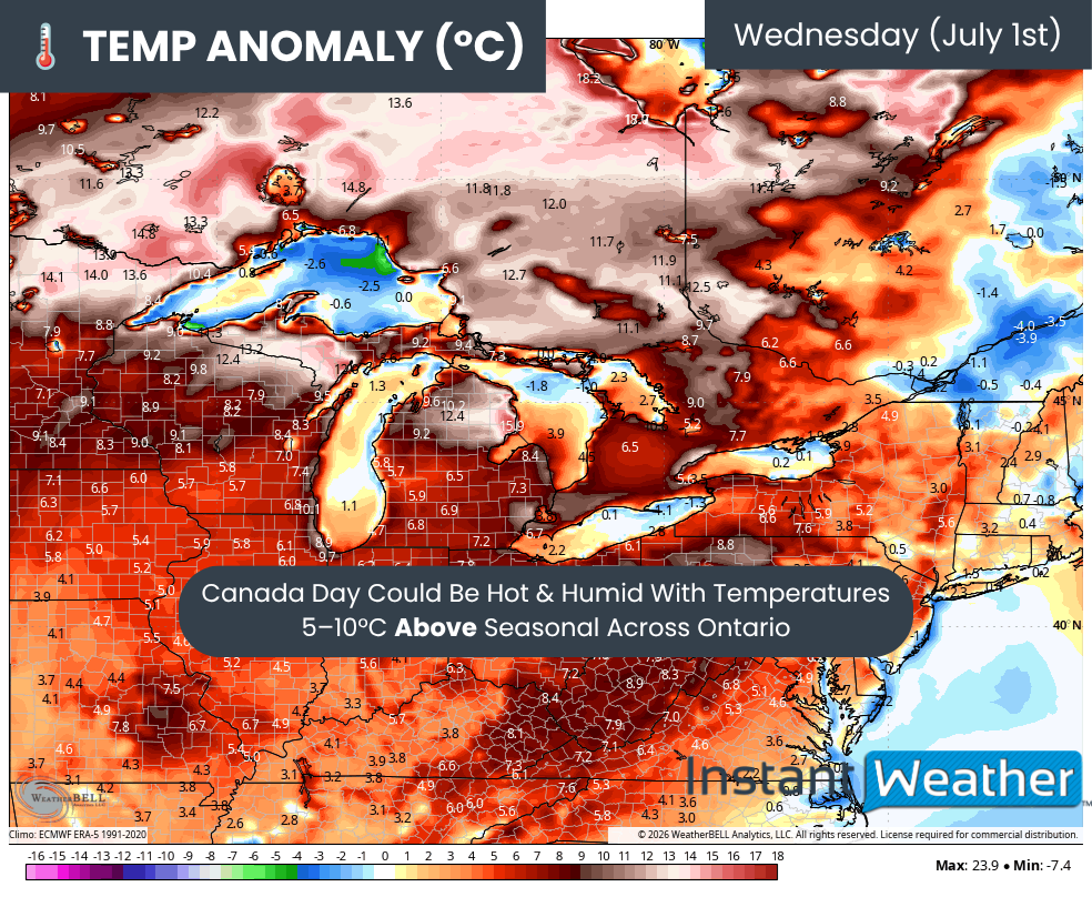
TEMP ANOMALY - MAP FROM WEATHERBELL
Looking beyond Thursday, the severe weather threat briefly settles down. Friday may bring a very isolated thunderstorm risk across Eastern Ontario, particularly near the Ottawa Valley, while much of the weekend currently appears relatively quiet from a severe weather perspective.
The bigger story heading into next week will likely be the return of significant heat.
Temperatures are expected to steadily climb through the weekend, with many areas approaching or exceeding 30°C by Monday. Current medium-range guidance suggests the heat could continue to intensify into the middle of next week, potentially peaking around Canada Day.
Some forecast models are indicating temperatures running between 5 and 10°C above seasonal averages, with localized anomalies approaching 15°C in parts of Ontario on Canada Day. If those projections verify, daytime highs could reach the low to mid 30s across portions of both Southern and Northern Ontario.
When combined with increasing humidity, it may feel close to 40°C in many communities.
This surge of heat and humidity will also provide plenty of fuel for additional thunderstorm development. While it is still too early to determine exactly which days will carry the greatest severe weather risk, there are increasing signs that we could be entering a much more active pattern over the next one to two weeks. Exactly when storms develop will depend on the arrival of cold fronts and other triggering mechanisms, something that will become much clearer once higher resolution models come into range.
We'll continue monitoring both Thursday's severe weather potential and the possible prolonged heat event expected next week. Stay tuned for forecast updates throughout the coming days as confidence continues to increase.


