Tornado Risk for Regina Area as Significant Severe Storm Risk Target Saskatchewan & Manitoba Saturday
/
NOTE: YOU CAN CLICK ON THE MAP TO OPEN A ZOOMABLE IMAGE
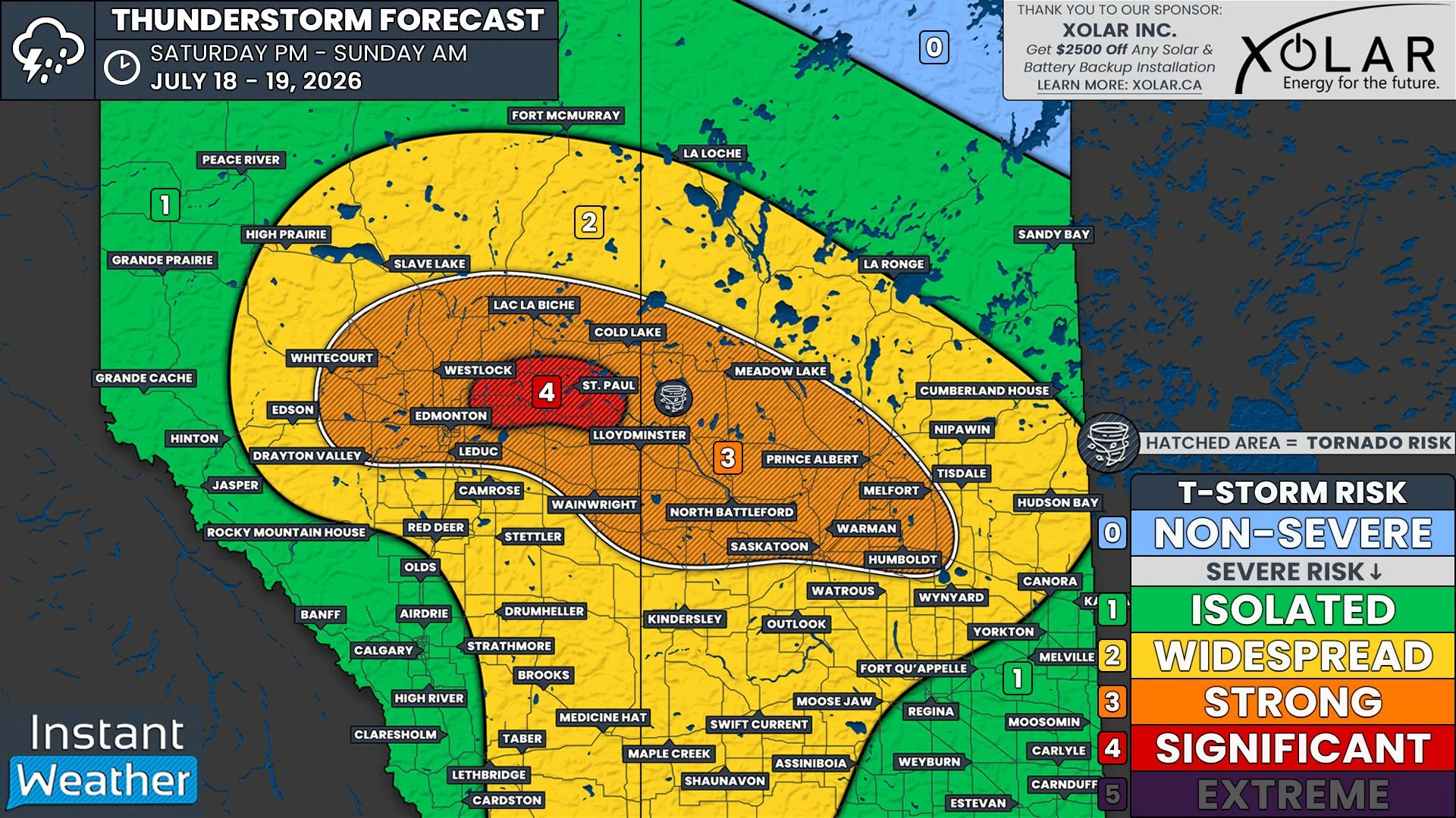
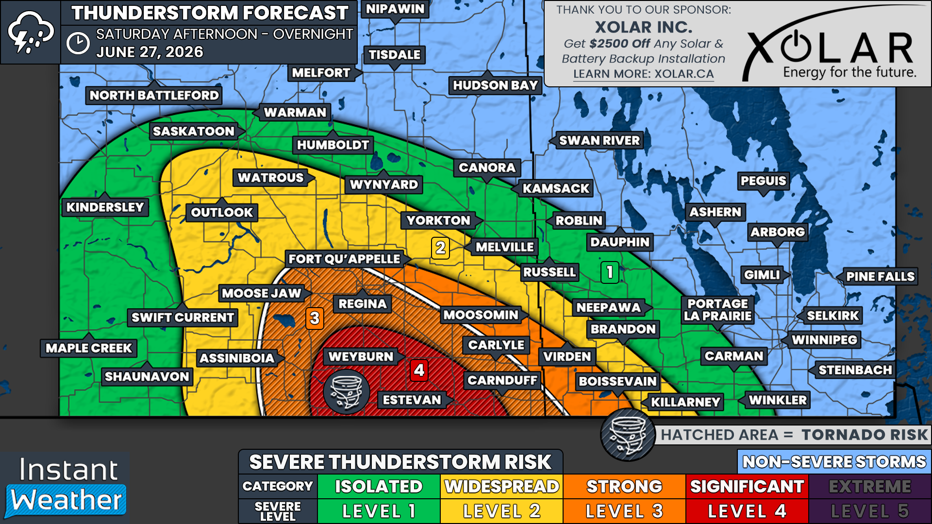
After a brief reprieve from active weather across Saskatchewan and Western Manitoba, the threat of severe thunderstorms returns on Saturday. This round of storms could bring a potentially significant severe weather risk to portions of Southeastern Saskatchewan, especially around Weyburn and Estevan.
Isolated thunderstorms are expected to develop near the International Border around the dinner hour. Any storms that form could quickly become supercells capable of producing all severe weather hazards, including tornadoes, golf ball-sized hail and destructive wind gusts up to 120 km/h.
There is also a strong severe weather risk extending northward toward Assiniboia, Moose Jaw and Regina. An isolated tornado cannot be ruled out in these areas as well, although confidence in storm development is lower compared to locations closer to the border.
Further south, additional thunderstorms are expected to develop across Montana and North Dakota. As the evening progresses, these storms are forecast to merge into a large complex that will race northeast toward Saskatchewan and Southwestern Manitoba.
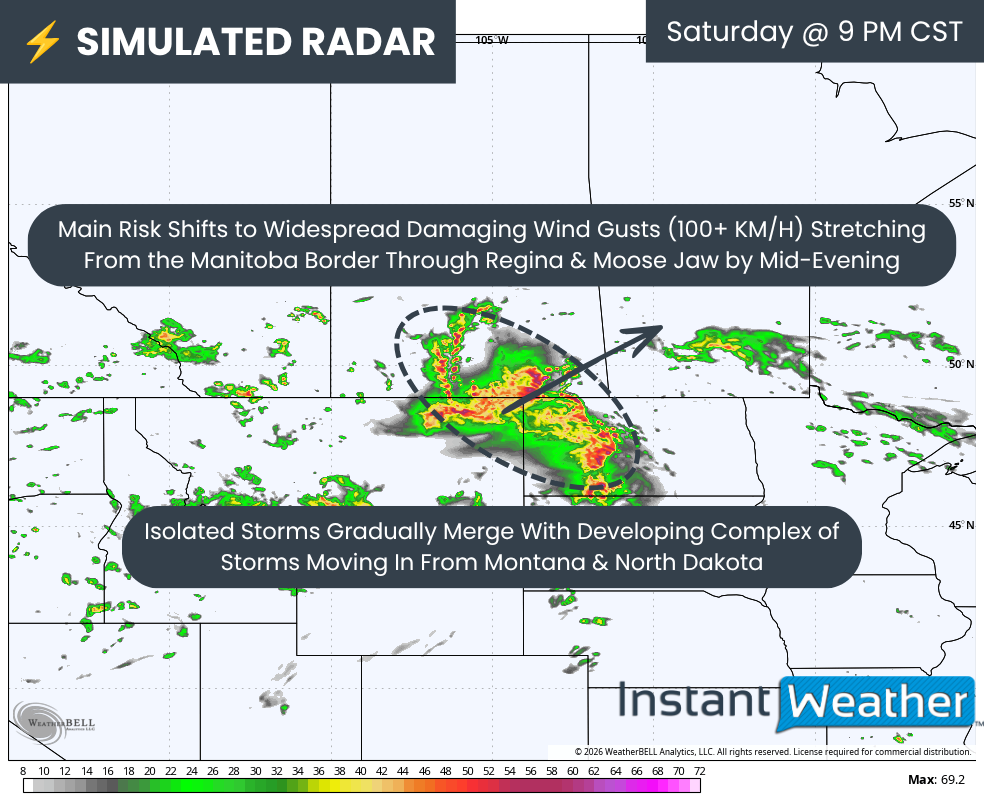
The earlier isolated supercells over Southeastern Saskatchewan are expected to be absorbed into this larger storm complex as it crosses the border. As this happens, the primary threat will shift from large hail and tornadoes to widespread damaging wind gusts as the storms organize into a fast-moving line during the mid and late evening hours.
This line is expected to sweep northeast from Regina toward the Manitoba border. There is still some uncertainty regarding how well it will maintain its strength after sunset, as the loss of daytime heating will reduce available instability. However, we expect at least an isolated to widespread severe weather risk to continue past midnight as the storms approach the Yorkton and Brandon corridor.
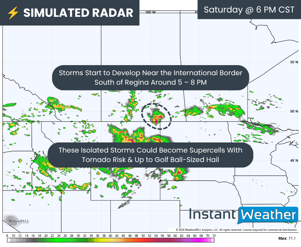
SIMULATED RADAR - MAP FROM WEATHERBELL
Based on the latest data, isolated thunderstorms are most likely to develop between 5 and 7 PM CST near the International Border. These storms could impact the Weyburn and Estevan areas as they rapidly intensify into supercells capable of producing large hail, damaging wind gusts and tornadoes.
The environment will be particularly favourable for tornadic development during the first few hours of these storms' lifespan. The greatest tornado risk appears to be closest to the border, although this threat could extend northwest toward Moose Jaw and Regina if storms are able to develop there during the late afternoon and early evening.
SIMULATED RADAR - MAP FROM WEATHERBELL

As the mature line of storms over Montana and North Dakota advances into Saskatchewan, the earlier isolated storms are expected to merge into the line, forming a bowing segment stretching from Regina to the Manitoba border.
Although the tornado threat will decrease once the storms become linear, a brief QLCS spin-up tornado cannot be ruled out, particularly near any bookend vortices that develop within the line. The primary hazard, however, will become widespread damaging wind gusts, with localized gusts over 100 km/h possible. The hail threat will also diminish by this stage, although quarter to toonie-sized hail may still accompany the strongest storms.
The line will continue sweeping across Southeastern Saskatchewan and into Southwestern Manitoba during the overnight hours. While isolated damaging wind gusts will remain possible within the strongest portions of the line, there is still uncertainty regarding how well the storms will maintain their intensity after midnight.