


Severe Storm Risk Targets GTA and Southern Ontario Thursday With Damaging Winds Possible
/
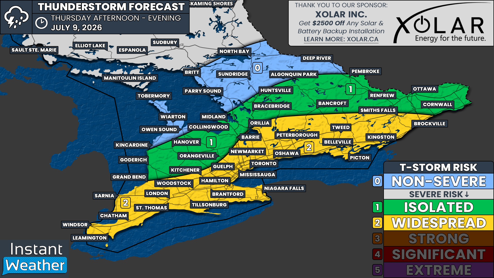
NOTE: YOU CAN CLICK ON THE MAP TO OPEN A ZOOMABLE IMAGE
With the return of more seasonal temperatures across Southern Ontario, the past week has been fairly quiet on the storm front. That has certainly been a noticeable change compared to the nearly daily severe weather risks we were dealing with during the prolonged heat event that kicked off the month.
However, that quieter pattern is expected to come to an end on Thursday as a cold front sweeps across Southern Ontario during the afternoon, bringing back the threat for severe thunderstorms in some areas.
The highest risk for severe weather appears to be focused on Deep Southwestern Ontario, extending along the Lake Erie shoreline, through the Greater Toronto Area and along the Hwy 401 corridor into Kingston. This is where we have a widespread severe weather risk, with multiple severe storms possible through the afternoon.
Based on the latest data, a line of storms is likely to develop along the approaching cold front and move into an environment supportive of some of these storms becoming severe. The main threat appears to be damaging wind gusts, but large hail and localized flooding will also be possible with the strongest storms.
As for the tornado risk, it appears to be highest from around Lake Simcoe eastward into the Kingston area. However, this risk is still fairly questionable and will depend on how storms develop and interact with the local environment.
Join Us on YouTube for Storm Coverage:
We'll be providing comprehensive live coverage of any storms that develop Thursday on our YouTube channel. Our team will be tracking storms in real time with live radar analysis, warnings, and storm reports, so if severe weather threatens your area, be sure to join us live to help stay informed.
The main timeframe for storm development appears to begin during the early afternoon, with storms likely stretching from Lake Simcoe through Kitchener, London and into the Sarnia area between 1 and 4 PM.
These storms are expected to slowly track south and east through the afternoon, potentially moving into the Golden Horseshoe, Peterborough and Kingston area by the mid to late afternoon.
Keep in mind, not everyone will see severe storms. This is not expected to be a solid wall of storms affecting every community. Instead, storms will likely be somewhat isolated to scattered, but the environment in place means that any storm that does develop could become severe.
The storm risk should quickly diminish after the dinner hour as daytime heating fades and the front moves through. However, this will depend on the exact timing of the front. If it arrives a little later than expected, the severe risk may continue into the early evening hours for some areas.
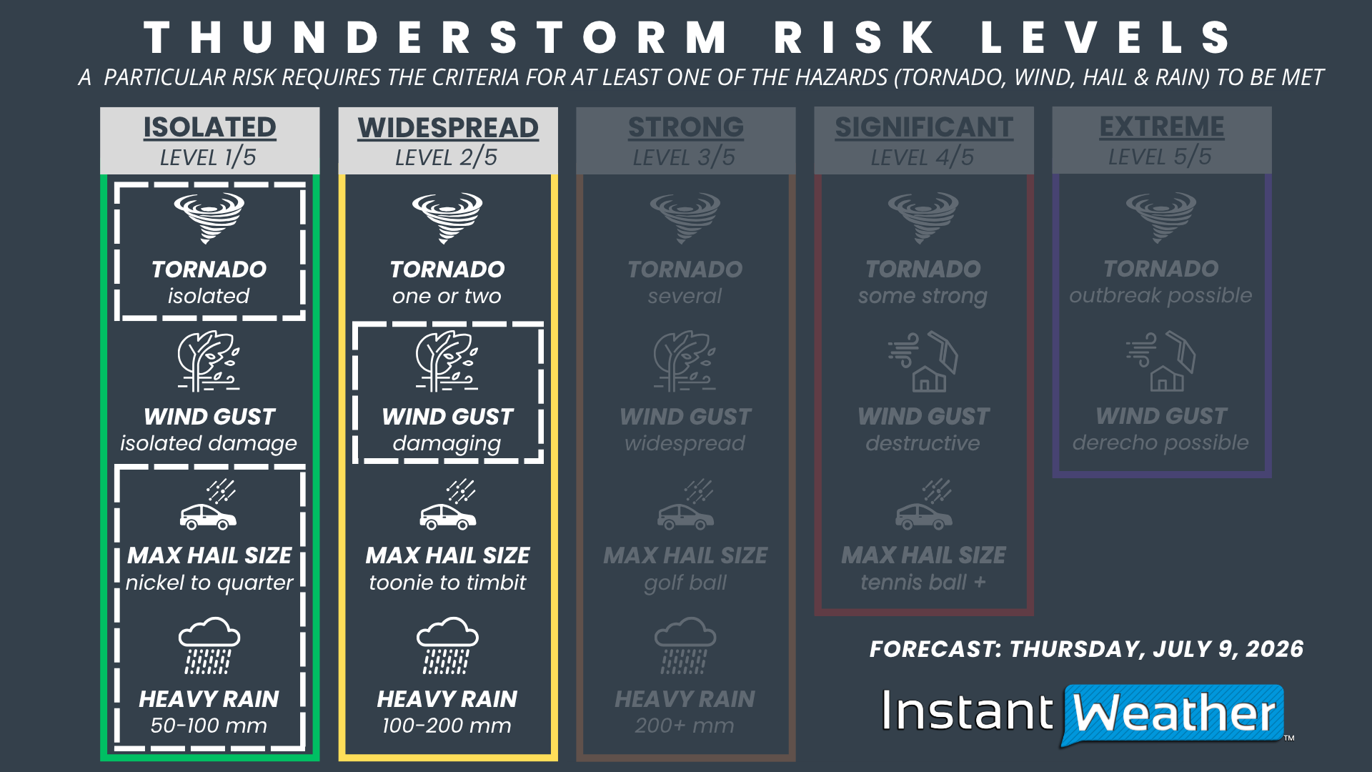
NOTE: YOU CAN CLICK ON THE GRAPHIC TO OPEN A ZOOMABLE IMAGE

Based on the environment, we have gone with a ‘widespread’ severe weather risk, mainly driven by the potential for damaging wind gusts. Nickel to quarter-size hail and an isolated tornado are also possible.
This risk zone includes Windsor, Chatham, Sarnia, London, Hamilton, Niagara Falls, Kitchener, Guelph, Toronto, Newmarket, Peterborough, Belleville, Kingston and Brockville.
We also have an isolated severe risk for the rest of Southwestern Ontario, through Central Ontario and into the Ottawa Valley. This includes Ottawa, Cornwall, Renfrew, Bancroft, Muskoka, Orillia, Barrie, Midland, Collingwood, Orangeville, Hanover, Kincardine and Goderich.
Storms in this zone are more likely to remain non-severe, but we can’t rule out one or two isolated severe storms. This is especially true if the front is slower than expected, which could allow stronger storms to develop farther north and west before tracking into the main risk zone.



