Widespread Tornado and Large Hail Threat with Another Risk of Severe Thunderstorms in Alberta & Saskatchewan Saturday
/
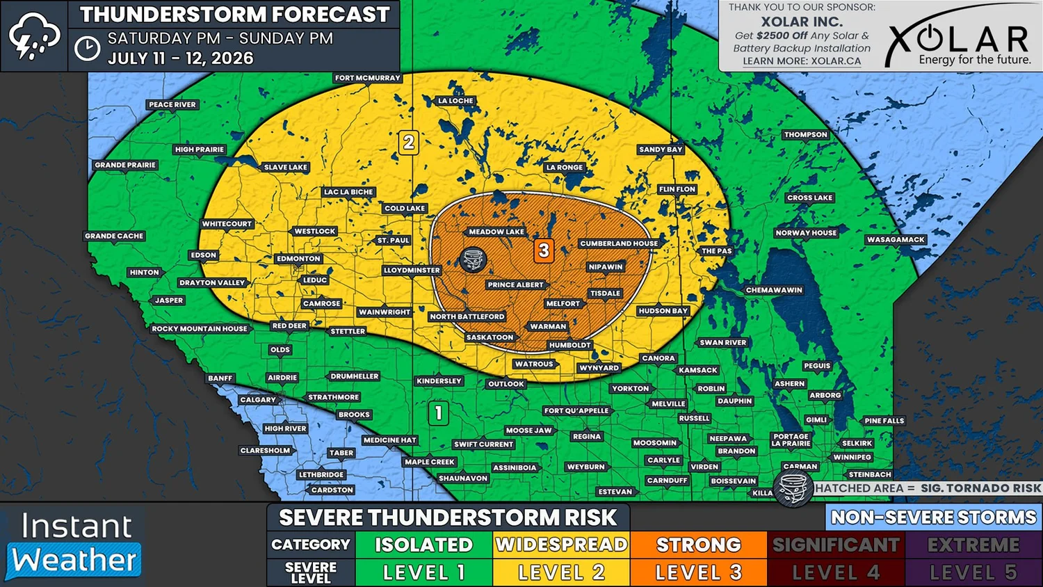
NOTE: YOU CAN CLICK ON THE MAP TO OPEN A ZOOMABLE IMAGE
Following yesterday's widespread severe weather, in which multiple tornadoes were reported to have touched down in Central Saskatchewan, as well as one possibly touching down to the west of Edmonton, we're in for yet another day with the risk for strong severe thunderstorms.
For several days, weather models have been showing that the environment could be extremely unstable today, especially across much of Saskatchewan, which could result in a fairly significant severe weather outbreak. Working against this, however, is the likelihood that there could actually be too heat higher up in the atmosphere, which could create a strong capping inversion that would hinder thunderstorm development. This is expected to be the case for much of Southern Saskatchewan today, where there will be a more isolated severe risk. It's important to note that any storms that are able to develop in this region will probably be quite strong.
Shifting northward, the capping should be less of an issue in Central and Northern parts of Alberta and Saskatchewan. Across this large swath of the Prairies, severe thunderstorms are expected to develop much more readily in a favourable environment.
Although there are already some thunderstorms this morning in Central and Northern Alberta, the storms that we are most concerned about are expected to beginning developing early this afternoon in Western Alberta, which will track mostly eastward through the afternoon.
As these storms cross into Saskatchewan early this evening, they could strengthen considerably as they move through the most ideal environment. These thunderstorms are expected to maintain their strength as they cross Saskatchewan during the evening and into the overnight hours. As they approach the provincial border and cross into Western Manitoba, the storms are expected to weaken and then dissipate in the early morning hours.
At their strongest, the severe thunderstorms today could easily produce large golf ball to tennis ball size hail, damaging wind gusts up to and possibly exceeding 100km/h, and heavy rain. There will be a widespread risk of tornadoes today in the area outlined in yellow and even in Southern Saskatchewan if storms are able to form there, but the most significant risk will be in the orange region. An area of particular concern today will be around North Battleford, Saskatoon, and Prince Alberta.
This is looking like it could be another long day with a heightened severe weather threat across the Prairies. Given today’s widespread tornado risk, please ensure that you have all of your devices charged and that you have more than one way to receive critical alerts. We expect to be livestreaming today’s storms so be sure to tune in!