Potential Record-Breaking Heat to Fuel Severe Thunderstorm Threat Across Southern Ontario Tuesday
/
NOTE: YOU CAN CLICK ON THE MAP TO OPEN A ZOOMABLE IMAGE
Dangerously hot temperatures are returning to Southern Ontario, bringing another multi-day heat wave to the region. This heat wave is expected to peak on Tuesday, when temperatures could climb into the mid to upper 30s across many communities.
As temperatures rise, so does the instability in the atmosphere, and Tuesday will be no exception. The intense heat will help fuel the potential for strong to severe thunderstorms across parts of Southern Ontario.
The greatest severe weather threat is expected to focus on the Ottawa Valley, where a cold front will move through the hot, humid air during the late afternoon and early evening. As the front arrives, it is expected to spark a line of thunderstorms capable of quickly becoming severe.
The environment appears favourable for some of these storms to develop into supercells capable of producing all severe weather hazards, including destructive wind gusts, golf ball-sized hail and a few tornadoes.
Elsewhere across Southern Ontario, widespread thunderstorm development is not expected as there is no well-defined trigger in place. However, isolated storms could still develop along lake breeze boundaries or from outflow boundaries generated by other storms. With plenty of instability available, any storm that manages to form could become severe. Most communities, however, are expected to remain dry on Tuesday.
Join Us on YouTube for Storm Coverage:
We'll be providing comprehensive live coverage of any storms that develop Tuesday on our YouTube channel. Our team will be tracking storms in real time with live radar analysis, warnings, and storm reports, so if severe weather threatens your area, be sure to join us live to help stay informed.
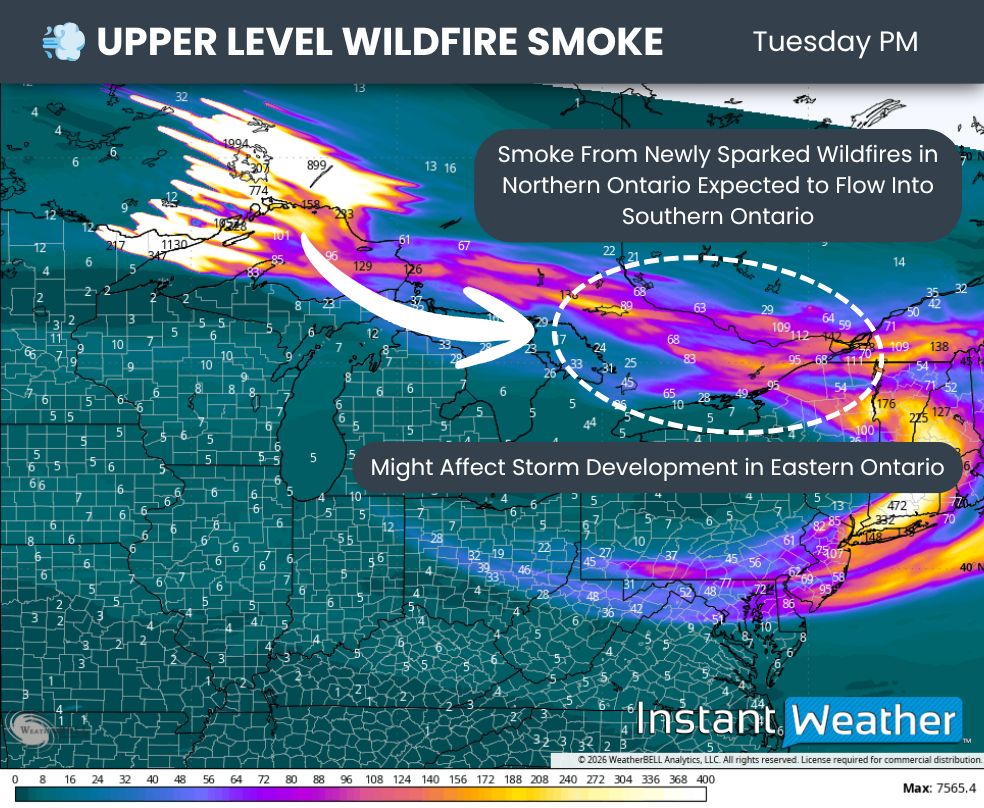
Another developing story that could have significant implications for Southern Ontario’s weather is the rapid increase in wildfire activity across Northwestern Ontario. A large number of new wildfires ignited over the past day, and the smoke from these fires is expected to begin spreading into Southern Ontario as early as Tuesday. An even more significant plume is expected to arrive on Wednesday.
In addition to air quality concerns, this smoke could also influence thunderstorm development on Tuesday by limiting the amount of sunshine reaching the surface. If enough smoke is present, it could reduce instability and lead to fewer storms than currently expected.

NOTE: YOU CAN CLICK ON THE MAP TO OPEN A ZOOMABLE IMAGE
Tuesday is shaping up to be a sweltering day, with temperatures climbing above 35°C across a large portion of Southern Ontario and potentially approaching the 40°C mark in a few locations. That’s before factoring in the humidity, which could make it feel more like the mid to upper 40s.
The hottest conditions are expected in a corridor stretching from Deep Southwestern Ontario through the Golden Horseshoe and into the Ottawa Valley. Afternoon highs here will likely range between 36 and 38°C, with parts of the Greater Toronto Area potentially reaching 39 to 40°C.
One reason the Greater Toronto Area could end up even hotter than surrounding communities is because of the urban heat island effect. Cities are filled with concrete, asphalt and buildings that absorb heat from the sun throughout the day and slowly release it back into the surrounding air. With fewer trees and green spaces to provide cooling, temperatures in urban areas can end up several degrees warmer than nearby rural locations, especially during prolonged heat waves.
The remainder of Southern Ontario can expect highs ranging from 30 to 36°C. Communities located directly along the northeastern shores of Lake Erie and Lake Ontario, as well as the eastern shores of Lake Huron and Georgian Bay, could be 5 to 10°C cooler thanks to cooling lake breezes.
Humidity is not expected to be quite as intense as it was during the late June heat wave, when humidex values approached 50°C in some areas. Even so, it will still make conditions feel like the low to mid 40s, with a few locations around the Golden Horseshoe potentially approaching the upper 40s.
These temperatures can become dangerous very quickly, especially for older adults, young children, people with chronic health conditions and anyone spending extended periods outdoors. Stay well hydrated, avoid strenuous outdoor activities during the hottest part of the day, wear lightweight clothing and seek air-conditioned spaces whenever possible.
Never leave children or pets inside a parked vehicle, even for a few minutes, as temperatures inside can rise to life-threatening levels in a very short amount of time!
DATA FROM WEATHERBELL
The hot, dry weather has also created ideal conditions for wildfire growth across Northwestern Ontario, and we’ve seen exactly that over the past 12 hours.
More than a dozen new wildfires have ignited, with many of them concentrated northwest of Thunder Bay. A southeasterly wind flow is expected to carry smoke from these fires into Southern Ontario over the next several days.
Initially, much of this smoke should remain high in the atmosphere. However, by Wednesday we could be dealing with a significant wildfire smoke event across Southern Ontario as more of the smoke mixes down to the surface, potentially leading to hazardous air quality. More details on that once models start ingesting the data from the new fire.
Even Tuesday’s elevated smoke could influence our weather, particularly across Central and Eastern Ontario. We’ve seen in the past that thicker smoke can reduce the amount of sunlight reaching the ground, limiting daytime heating and making it more difficult for thunderstorms to develop.
As a result, there is a real possibility that Tuesday’s severe weather threat could underperform if the smoke becomes thick enough to suppress storm development.
DATA FROM WEATHERBELL
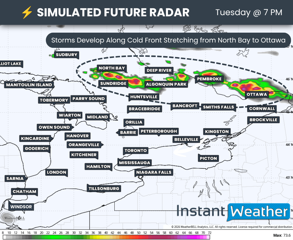
Assuming the smoke does not significantly interfere, the latest model data shows a line of thunderstorms developing around the dinner hour from North Bay to just north of Ottawa.
The exact timing will depend on when the cold front arrives, but the primary threat window currently appears to be between 4 PM and 10 PM.
These storms are then expected to track southeast through the Ottawa Valley, potentially affecting portions of Central Ontario before continuing into southeastern Quebec and eventually crossing into the northeastern United States.
We could also see isolated thunderstorms develop during the afternoon and early evening across other parts of Southern Ontario. These would likely be triggered by lake breeze boundaries or other localized features that weather models often struggle to resolve.
Any storm that is able to develop could quickly become severe, producing damaging wind gusts and large hail. The greatest tornado threat remains focused across Eastern Ontario.
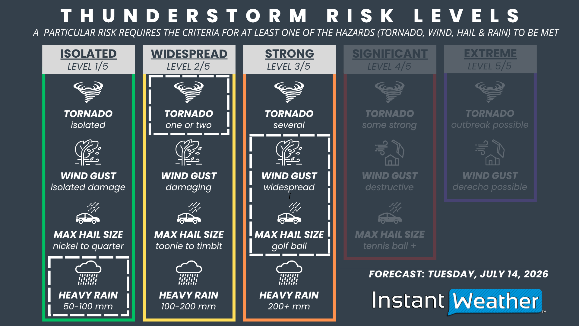
NOTE: YOU CAN CLICK ON THE graphic TO OPEN A ZOOMABLE IMAGE

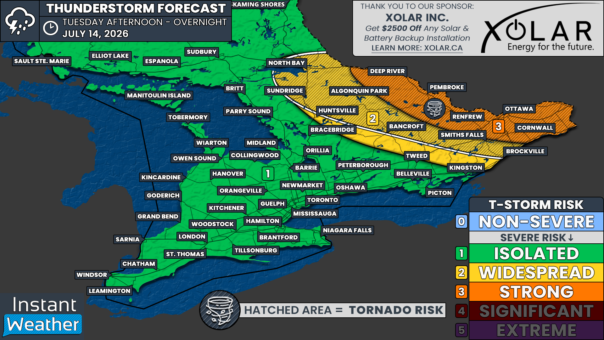
Based on the expected environment, we’re forecasting a “Strong” (Level 3 of 5) severe weather risk for Ottawa, Cornwall, Smiths Falls, Renfrew, Pembroke and Deep River. This reflects the potential for widespread damaging wind gusts, golf ball-sized hail, one or two tornadoes and localized flash flooding.
A “Widespread” (Level 2 of 5) severe weather risk extends across the rest of Eastern and portions of Central Ontario, including Brockville, Bancroft, Huntsville, Algonquin Park, Sundridge and North Bay. Confidence is a bit lower than across the Ottawa Valley, but several severe storms remain possible with damaging wind gusts, Timbit-sized hail and an isolated tornado.
The remainder of Southern Ontario is under an “Isolated” (Level 1 of 5) severe weather risk. Most communities in this area will likely remain storm-free. However, if a thunderstorm is able to develop along a lake breeze or another localized boundary, it could produce isolated damaging wind gusts and up to quarter-sized hail.