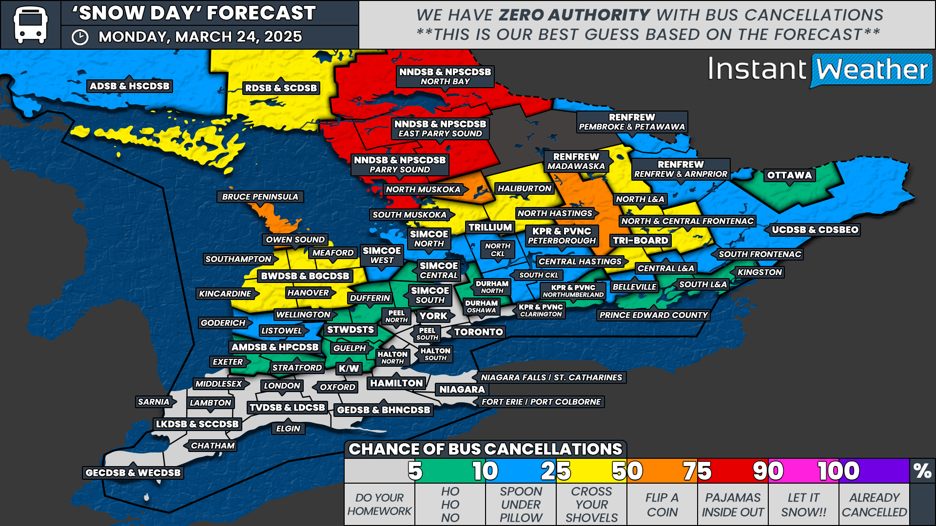
'Ice Day' Forecast: Schools Across Parts of Central Ontario Will Be Closed on Monday Due to Major Ice Storm Damage

NOTE: YOU CAN CLICK ON THE MAP TO OPEN A ZOOMABLE IMAGE

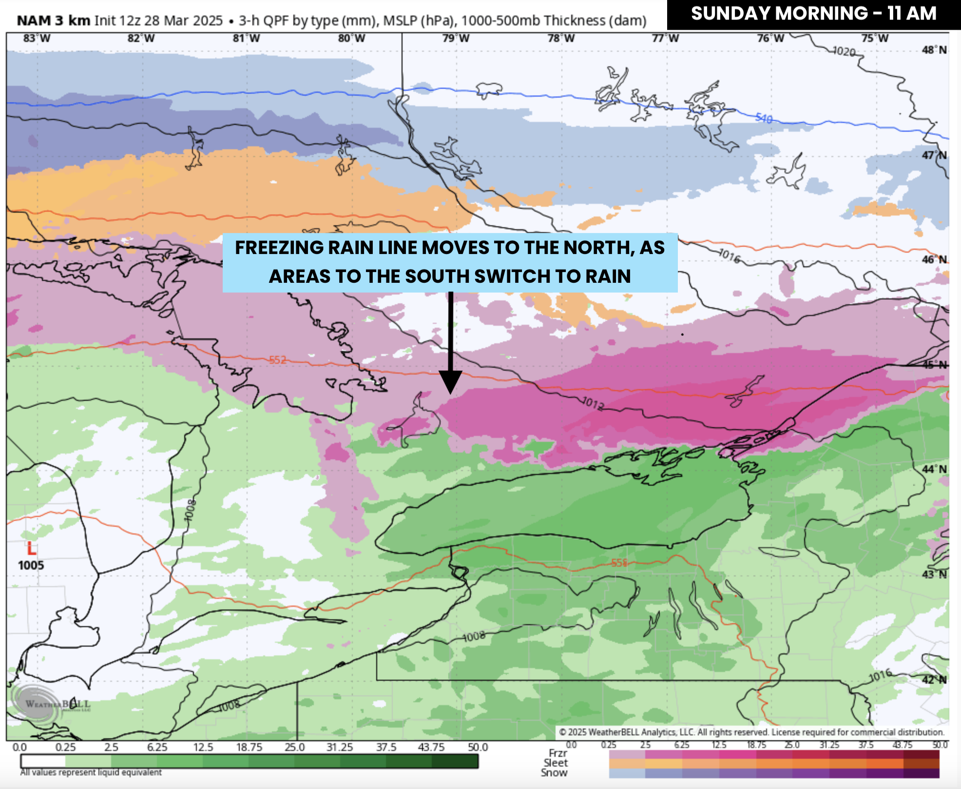
A major ice storm has left much of Central Ontario paralyzed, with widespread power outages and extensive damage. While the freezing rain threat has ended for the hardest-hit regions, the impact is far from over. Many communities remain without power, and recovery efforts are only just beginning. With power restoration expected to take days in some areas, school closures on Monday are inevitable.

As of 6:30 PM on Sunday, multiple school boards have already announced they will be closed on Monday due to the ongoing impacts of the storm. This includes Simcoe County District School Board, Trillium Lakelands District School Board, Kawartha Pine Ridge District School Board, and Simcoe Muskoka Catholic District School Board. These regions, among the hardest hit, are highlighted in dark purple on the map.

We are also highly confident that additional school closures will be announced in other severely impacted areas, including Tri-Board, North Durham, and Near North. Given the sheer number of power outages, downed trees, and icy roads, it’s difficult to imagine how schools in these regions could safely operate.

Dufferin and Meaford were also hit hard by the storm, and while some cancellations or closures are possible, the impacts there were not as widespread. As a result, the school board may opt to close select schools rather than issuing a full regional closure.

Meanwhile, in the Ottawa Valley, the impacts of this storm have been less severe. However, freezing rain is ongoing this evening and will continue into the overnight hours before transitioning to rain. Road conditions could still be hazardous, especially on rural routes. Because of this, there is a strong chance of school bus cancellations for the Renfrew and Upper Canada school boards.

As for the City of Ottawa, it’s a 50/50 call at this point. The urban school board generally has a higher tolerance for winter conditions since most students do not rely on rural bus routes. That said, with lingering ice and freezing rain, cancellations remain a possibility.


Disclaimer: Instant Weather has zero authority when it comes to bus and school closures.

It is completely up to the school boards, bus companies, local authorities, and parents to decide what is best for their children. This is our best guess based on our forecast.

Dangerous Ice Storm Likely This Weekend With Widespread Power Outages Across Parts of Southern Ontario

NOTE: YOU CAN CLICK ON THE MAP TO OPEN A ZOOMABLE IMAGE

Concern is rapidly growing for what is shaping up to be a potentially devastating ice storm this weekend across parts of Central and Eastern Ontario. Prolonged freezing rain, beginning Friday evening, is expected to persist throughout much of the weekend, leading to substantial ice accretion on exposed surfaces.

This storm has the potential to reach ice accumulation levels not seen in years—or even over a decade. With up to 40mm of ice accretion possible, widespread power outages are likely in the hardest-hit regions, including Muskoka, Simcoe County, Kawartha Lakes, Peterborough, and Kingston.

Some of these power outages could last for days or even weeks, especially in more rural areas with dense tree coverage. Trees weighed down by ice are likely to fall, taking power lines with them. Travel conditions will also be significantly impacted, as ice-covered roads become extremely dangerous.

For Northern Ontario, the storm will start as a classic winter system, bringing heavy snowfall to Northeastern Ontario throughout Saturday. A second round of precipitation on Sunday could introduce freezing rain and ice pellets further south, affecting areas like Elliot Lake, Sudbury, and North Bay. Snowfall totals in Northeastern Ontario are expected to range from 20 to 30cm, making travel difficult.

Even the Ottawa Valley will see significant snowfall, with up to 20cm possible, along with a mix of ice pellets. By Sunday, freezing rain could become a concern for the region as temperatures rise and the precipitation type shifts.

PRECIPITATION TYPE - MAP FROM WEATHERBELL

As of Friday afternoon, rain is already moving into Southwestern Ontario. By the evening, precipitation will spread north and east into Central and Eastern Ontario.

Based on the latest data, a band of heavy snow is expected to develop along a corridor stretching from Sudbury through North Bay and into the Ottawa region. To the south, an area of freezing rain will form over the Bruce Peninsula and extend into regions around Lake Simcoe.

ESTIMATED TEMPERATURE - MAP FROM WEATHERBELL

How far south the freezing rain spreads remains uncertain. Model guidance suggests surface temperatures will hover near the freezing mark across Barrie and the Greater Toronto Area (GTA).

Even a fraction of a degree difference could significantly alter how much freezing rain accumulates. If the air remains colder than expected, freezing rain could be more widespread. However, a slightly warmer scenario would push the freezing rain line further north.

Confidence is highest for freezing rain in northern sections of Simcoe County, Kawartha Lakes, and Muskoka. These areas are most likely to remain below freezing for an extended period, allowing heavy ice accretion to build up.

PRECIPITATION TYPE - MAP FROM WEATHERBELL

The most intense icing is expected overnight into early Saturday morning. The worst conditions will stretch from Muskoka through Peterborough and into Kingston.

Once again, temperature will be the deciding factor. Some areas, such as Barrie and Newmarket, sit right on the edge between freezing rain and regular rain. If cold air lingers longer than anticipated, freezing rain could extend as far south as the northern GTA, as well as higher elevations like the Dundalk Highlands.

PRECIPITATION TYPE - MAP FROM WEATHERBELL

Through Saturday morning and afternoon, light to moderate freezing rain or drizzle is expected to persist across portions of Central Ontario, particularly around Lake Simcoe. However, the intensity will decrease compared to the earlier hours.

Further south, rain will continue across Southwestern Ontario and the GTA. This is when we expect the warmest temperatures of the storm. Some areas in Deep Southwestern Ontario, including Windsor, could surge into the 20s, while Central Ontario remains near or below freezing.

PRECIPITATION TYPE - MAP FROM WEATHERBELL

By Saturday evening, another round of heavy precipitation is expected to push into Central Ontario. At the same time, temperatures will steadily drop. Regions that saw rain in the afternoon—including parts of the GTA and Barrie—may transition back to freezing rain.

ESTIMATED TEMPERATURE - MAP FROM WEATHERBELL

Model data suggests that by late Saturday night into Sunday morning, the freezing rain line could shift southwest of the GTA. This could result in several hours of freezing rain across Kitchener, Waterloo, and parts of the Toronto area.

Deep Southwestern Ontario, including Windsor, Sarnia, and London, is expected to remain unaffected, staying well above freezing.

PRECIPITATION TYPE - MAP FROM WEATHERBELL

Sunday morning will bring a gradual transition from freezing rain to regular rain across the GTA as temperatures climb above freezing. However, elevated areas northwest of the city, such as Guelph, Orangeville, and Shelburne, could see freezing rain linger for a few extra hours.

For Central Ontario, the freezing rain will continue into early Sunday afternoon as the main area of precipitation slowly shifts north.

By Sunday afternoon, the Ottawa Valley may begin transitioning from snow to ice pellets and then to freezing rain as temperatures rise.

PRECIPITATION TYPE - MAP FROM WEATHERBELL

Most of Southern Ontario will warm above the freezing mark by late Sunday, finally pushing the freezing rain threat northward.

However, by Sunday night into Monday morning, the risk of freezing rain will shift to Northeastern Ontario, including Sudbury and North Bay.

Meanwhile, heavy snow and ice pellets will impact more northern regions, such as Wawa and Timmins.

NOTE: YOU CAN CLICK ON THE MAP TO OPEN A ZOOMABLE IMAGE

Predicting exact ice accretion remains challenging, as many factors influence how much ice actually builds up. The amount of freezing rain you experience may vary significantly from nearby areas due to microclimate effects, surface conditions, and temperature fluctuations.

Some high-resolution model runs suggest an extreme scenario with localized pockets of over 50mm—possibly even 75mm—of freezing rain. However, because much of this precipitation will fall in a relatively short timeframe, not all of it will necessarily adhere to surfaces.

Given this, we are forecasting general ice accretion between 25 and 40mm in the hardest-hit areas. This includes the northern tip of the Bruce Peninsula, Muskoka, Orillia, Barrie, Orangeville, Collingwood, Lindsay, Peterborough, Belleville, and Kingston.

If temperatures are slightly colder than expected, some locations could exceed 40mm of ice accretion, particularly where conditions allow for more efficient accumulation.

To put this into perspective, we can use the Sperry-Piltz Ice Accumulation Index (SPIA Index). With forecasted ice accumulations of 25-40mm (1-1.4”), this storm falls into a Category 4 ice event—even before factoring in wind.

While we are not expecting extreme winds, gusts of 40-50km/h (25-30 mph) in some areas could push this storm into Category 5 territory. According to the SPIA Index, a Category 5 ice storm results in:

Catastrophic damage to entire exposed utility systems, including both distribution and transmission networks. Outages could last several weeks in some areas. Shelters needed.

For the Greater Toronto Area (GTA), ice accretion amounts will vary significantly. The biggest factor will be how long cold air remains trapped at the surface.

We currently expect between 10-15mm of ice for northern parts of the GTA, including York, Durham, and Peel regions. Kitchener and Waterloo will likely see between 5-10mm.

Closer to the Lake Ontario shoreline—including downtown Toronto—freezing rain amounts should be lower, around 2-5mm. However, if temperatures are colder than expected, ice accretion in the GTA could be higher, so it’s still best to prepare.

To the north, ice accretion amounts will drop off as freezing rain transitions to ice pellets and snow closer to the Ottawa Valley.

NOTE: YOU CAN CLICK ON THE MAP TO OPEN A ZOOMABLE IMAGE

In terms of snowfall, widespread totals between 20-30cm are expected across much of Northeastern Ontario through Monday. This includes Sudbury, North Bay, Chapleau, Timmins, and Kirkland Lake. Even Thunder Bay could see 10-20cm of snow, mainly earlier in the weekend.

Along the Quebec border, snowfall amounts will range from 10-20cm in areas like the Ottawa Valley and Cornwall. Further southwest, freezing rain and ice pellets will be the dominant concern, leading to lower snowfall totals.

This storm remains highly dynamic, with small temperature fluctuations potentially making a massive difference in what type of precipitation falls. We will continue to monitor the latest data and provide updates as the situation evolves. Stay safe and stay prepared.

Weathering the Storm: How to Prepare For an Ice Storm

In advance of the ice storm anticipated to impact the province, we at Instant Weather want to make sure that everyone is ready in the event of potential widespread and long term power outages. The impact of an ice storm is not just dependent on the amount of ice accretion, but also the winds associated with the storm. This is summarized using the Sperry-Piltz Ice Accumulation (SPIA) Index shown below.

It is important to be prepared for these situations so we have put together a list of items you should have on hand in case of an emergency:

  • Flashlight (windup or battery operated)

  • Radio (windup or battery operated)

  • Extra batteries

  • Portable cell phone charger

  • Water (2 litres per person per day)

  • Non-perishable canned or dried food

  • Manual can opener

  • Blankets

  • Candles and matches or lighters

  • First aid kit and any prescriptions/medical items

  • List of emergency numbers

  • Cash

  • Gasoline

Not sure what kind of food to have ready? Dried food like rice and pasta along with canned tuna can go a long way. Other items such as bread and granola bars are good for fibre and non-refrigerated fruits like bananas, oranges and apples help break up the high-sodium content found in dried foods. Another staple for many are storm chips. For water, an easy way to store a large amount is to fill a bathtub and use the water for drinking, cooking, and flushing toilets.

Since ice storms occur during the winter and early spring months, keeping warm is a major concern during extended power outages from ice storms. Electric baseboard heaters and space heaters will not work. However, natural gas furnaces will still work, but electrical components such as the blower, which forces the warm air through the vents, will not. There are some propane heaters that can be used indoors, but be careful because outdoor propane heaters produce carbon monoxide, making them very dangerous to use inside a home.

Another item worth adding to your emergency kit arsenal is a generator. Generators are available in a variety of sizes and capacities based on individual needs. There are a few things to consider when picking a generator: type, power and additional features.

There are home standby generators that are permanently in place and start up automatically when the power goes out. These units are large and can be quite expensive. There are also smaller, portable generators that either run strictly on gas or on either gas or propane (dual fuel). There is an added benefit of running your generator on propane as it less expensive to run.

Every generator has two power ratings: starting watts and running watts. In order to determine the power of generator you need, you first need to determine what appliances will be running. In the event of an emergency, you may find that the only necessities are the fridge and furnace fan.

It is EXTREMELY important to not run a generator in your house due to the risk of carbon monoxide poisoning.

With proper planning and preparation, everyone should be able to get through the stress that comes with extended periods without power. In the case of an ice storm, it’s important to stay indoors and reduce unnecessary travel. Also, we recommend not clogging up emergency lines with non-emergencies. Your power will be back before you know it!

Potential Major Ice Storm Threat on the Horizon for Southern Ontario This Weekend

NOTE: YOU CAN CLICK ON THE MAP TO OPEN A ZOOMABLE IMAGE

With the end of March approaching and the arrival of April, winter’s grip on Southern Ontario is loosening. However, Old Man Winter isn’t leaving quietly. Instead, the final days of March bring the potential for multiple rounds of heavy freezing rain across parts of the region.

The risk of freezing rain is set to begin late Friday as the first wave of precipitation moves in. This initial bout of freezing rain could be quite heavy at times, particularly across Central and Southern portions of Eastern Ontario. The Greater Toronto Area (GTA) may also see some freezing rain late Friday before transitioning to regular rain as temperatures rise overnight.

A second wave of freezing rain is expected to develop Saturday evening and continue through Sunday. However, this round carries more uncertainty, with forecast models disagreeing on how far north warm air will push at the surface. Some models concentrate the freezing rain in Northeastern Ontario and the Ottawa Valley, while others bring it much farther south, placing the GTA in the bullseye.

While there is still uncertainty regarding the exact track and intensity of the freezing rain, all major weather models agree on the overall setup. Cold air will remain locked in at the surface across parts of Southern Ontario, while a surge of warm air moves in aloft. This combination will create ideal conditions for freezing rain formation.

These conditions are expected to persist throughout much of the weekend, with multiple waves of freezing rain possible. Given the prolonged duration of freezing rain, significant impacts are likely. Thick layers of ice could accumulate on untreated surfaces, including trees and power lines. The weight of this ice may lead to substantial damage to the power grid, with outages that could take days—or even weeks—to repair.

PRECIPITATION TYPE - MAP FROM WEATHERBELL

Focusing on the first round, models are beginning to develop a clearer picture of where freezing rain will be most intense. Initial bands of precipitation should move into Southwestern Ontario by late Friday afternoon or evening.

As this precipitation reaches areas such as Kitchener, Owen Sound, and Barrie, it will encounter stubborn below-freezing temperatures at the surface. This will lead to freezing rain developing across these regions.

Further north, a band of heavy snow is expected to spread across areas near the northern shoreline of Lake Superior, extending into Timmins. In more southern locations, such as Sault Ste. Marie, Sudbury, and North Bay, ice pellets will likely be the dominant form of precipitation.

PRECIPITATION TYPE - MAP FROM WEATHERBELL

Models agree that warm air associated with this system will gradually work its way toward the surface, beginning in the southwest and pushing northeast through the night. As a result, some freezing rain may mix with regular rain, especially southwest of Lake Simcoe and near the Lake Ontario shoreline in the GTA.

The persistence of cold air at the surface remains a major question mark. Some models suggest that cold air will be more stubborn, leading to more sustained freezing rain in the GTA overnight and into Saturday morning.

What is more certain is that a particularly intense band of freezing rain will set up over Central Ontario, including the Bruce Peninsula, Muskoka, Simcoe County, Peterborough, and Kingston. Significant ice accumulation is expected in these areas, with freezing rain continuing into Saturday morning. While freezing rain will persist into the afternoon, it should gradually become more scattered in nature.

In the Ottawa Valley, ice pellets and snow will be the main concern. There remains uncertainty regarding snowfall totals, as accumulation will depend on how much mixing occurs with ice pellets. Estimates currently range from 10 to 20 cm, but if ice pellets dominate, snowfall amounts could be closer to 5 cm.

TEMPERATURE - MAP FROM WEATHERBELL

Looking at the temperature setup for this event, a sharp gradient will be present across Southern Ontario on Saturday morning. This is one of the factors making this forecast so tricky.

Below-freezing temperatures will be well-established over Central and Eastern Ontario, as indicated by areas northeast of the pink line on the map above. Meanwhile, Deep Southwestern Ontario—including Windsor, Sarnia, and London—will experience double-digit temperatures, with no threat of wintry precipitation.

The most uncertain area lies between the orange and pink lines on the map above. This includes much of the GTA and the Grey-Bruce region. Temperatures in these areas will hover near the freezing mark, placing them at the boundary between warm and cold air. If models are off by just a degree or two, it could mean the difference between an ice storm and plain rain.

NOTE: YOU CAN CLICK ON THE MAP TO OPEN A ZOOMABLE IMAGE

This represents our preliminary assessment of the hardest-hit areas from the first round of freezing rain. It’s important to note that this forecast covers conditions through Saturday night, but the threat of freezing rain will persist into Sunday and even Monday. There is less certainty regarding how the second round will play out, so our focus remains on the first round for now.

Confidence is highest for significant ice storm impacts in locations such as Tobermory, Wiarton, Owen Sound, Collingwood, Orangeville, Barrie, Midland, Orillia, Muskoka, Parry Sound, Peterborough, and Kingston. Ice accretion in these areas will likely exceed 10 mm and could even reach 20 to 30 mm in the worst-case scenarios.

As previously discussed, temperatures will play a crucial role in determining the extent of freezing rain along the narrow corridor that includes the GTA and Kitchener. Slightly colder temperatures could mean prolonged freezing rain, while a warmer solution would allow for a quicker transition to rain overnight Friday.

Those in Deep Southwestern Ontario and along the Lake Erie shoreline should see little impact, as temperatures will remain well above freezing, resulting in plain rain rather than freezing precipitation.

For more northern regions along the Quebec border, ice pellets and snow will be the dominant precipitation types. Locations such as North Bay, Pembroke, and Ottawa could see 10+ cm of snow, with a risk of ice pellets and possibly brief periods of freezing rain.

PRECIPITATION TYPE - MAP FROM WEATHERBELL

As the first round of freezing rain winds down across Southern Ontario, lingering pockets of freezing drizzle may persist across Central and Eastern Ontario through Saturday afternoon. In the GTA, temperatures could dip just enough to allow for a transition back to freezing rain later in the day.

The second round of freezing rain is expected to arrive by Saturday evening as energy moves in from the U.S. Midwest.

PRECIPITATION TYPE - MAP FROM WEATHERBELL

Models are in solid agreement that this second wave will set up another band of freezing rain in the same areas hit hardest by the first round, including Central Ontario and portions of the GTA. This freezing rain will persist overnight into Sunday morning. However, by Sunday morning, the models begin to diverge significantly.

A more northern track would see warm air winning out across Southern Ontario, allowing temperatures to rise and leading to a transition to rain near Lake Simcoe. This would push the freezing line northward into Northeastern Ontario and the Ottawa Valley. In this scenario, freezing rain would be confined to areas such as Sudbury and North Bay, while heavy snow would develop from Wawa to Timmins.

Both the Canadian and European models favor this northern solution, which would be the better outcome for Southern Ontario, as it would avoid a second major icing event. However, this would be worse news for Sudbury and North Bay, where a significant ice storm could unfold.

PRECIPITATION TYPE - MAP FROM WEATHERBELL

This more northern track has the warmer air winning out across Southern Ontario during the morning on Sunday. This gradually leads to a switch over to rain near Lake Simcoe as the freezing line puches north into Northeastern Ontario and the Ottawa Valley.

Then freezing rain would be contained to Northeastern Ontario including Sudbury and North Bay. While heavy snow extends from Wawa to Timmins.

Both the Canadian and European models favor this solution. Which would certainly be the better outcome for Southern Ontario as they escape a second icing event. But would be worst news for Sudbury and North Bay which could see an ice storm.

PRECIPITATION TYPE - MAP FROM WEATHERBELL

On the other hand, the American model suggests a much more southerly track, which would place Southwestern Ontario and the Golden Horseshoe directly in the path of heavy icing. This scenario would bring freezing rain through Sunday night into Monday morning, creating hazardous conditions for the Monday morning commute.

If this outcome materializes, widespread school bus cancellations across Southern Ontario would be likely on Monday morning. Meanwhile, areas farther north could see accumulating snow on top of earlier ice buildup.

Unfortunately, a significant cooldown is expected in the wake of this storm. By Monday evening, temperatures will plunge into the negative teens. Any ice that accumulates over the weekend will remain in place for several days, increasing the strain on the power grid as trees continue to fall onto power lines.

Regardless of how this storm unfolds, it is shaping up to be a high-impact winter event with potentially severe consequences in some areas. Prepare for treacherous travel conditions and the possibility of widespread power outages lasting multiple days.

We will provide further updates as the weekend approaches. Stay tuned and stay safe!

⚠️ Significant Winter Storm Risk For Ontario This Weekend With Three Days of Freezing Rain Possible 🚨

NOTE: YOU CAN CLICK ON THE MAP TO OPEN A ZOOMABLE IMAGE

It may say spring on the calendar but Ontario could get a rude reminder that winter is not done with us quite yet! ❄️🥶 Environment Canada meteorologists are forecasting the potential for a significant winter storm this weekend that could bringing several days of freezing rain, causing icy roads, tree damage, and possible power outages across much of Southern Ontario.

*To clarify, “Southern” Ontario includes Southwestern, Central, Golden Horseshoe and Eastern regions. From many questions we’ve received, it seems that often ‘Southern Ontario’ is mistaken for ‘Southwestern Ontario’.

Meanwhile, lake effect snow will create hazardous travel conditions midweek, and this potentially significant winter storm could extend the icy mess into Sunday. Confidence remains low on exact snowfall amounts and ice accumulation, but this system looks like could pack a punch—stay prepared and watch for updates!


📅 Tuesday, March 25, 2025

NOTE: YOU CAN CLICK ON THE MAP TO OPEN A ZOOMABLE IMAGE

📍 Location: Areas east of Lake Huron & Georgian Bay

🌨️ Hazard(s): Snow
📍 Location: Areas east of Lake Huron and Georgian Bay
Timing: Tuesday
⚠️ Impact(s): Hazardous travel conditions, reduced visibility

Confidence: Moderate
Impact: Moderate

🔹 Lake effect snow will develop early Tuesday morning with local snowfall amounts of 5 to 15 cm possible.


📅 Wednesday, March 26, 2025

NOTE: YOU CAN CLICK ON THE MAP TO OPEN A ZOOMABLE IMAGE

📍 Location: Areas east of Lake Huron

🌨️ Hazard(s): Snow
📍 Location: Areas east of Lake Huron
Timing: Wednesday morning
⚠️ Impact(s): Hazardous travel conditions & Reduced visibility

Confidence: Low
Impact Level: Moderate

🔹 The lake effect snow will drift southward Tuesday night into Wednesday morning, with local snowfall amounts of 5 to 15 cm possible. Snow is expected to ease near midday.


⚠️ Friday, March 28, 2025

NOTE: YOU CAN CLICK ON THE MAP TO OPEN A ZOOMABLE IMAGE

📍 Location: Portions of southwestern Ontario and the Greater Golden Horseshoe

🧊 Hazard(s): Ice
📍 Location: Portions of southwestern Ontario and the Greater Golden Horseshoe
Timing: Friday evening
⚠️ Impact(s): Icy surfaces such as roads and walkways

Confidence: Moderate
Impact Level: High

🔹 A prolonged freezing rain event is expected to begin Friday evening, with multiple waves of freezing rain. There is still uncertainty regarding the timing and exact location of the rain/freezing rain boundary. The freezing rain is expected to continue into the weekend for parts of southern, central, and eastern Ontario.


📍 Location: Northeastern, central, and eastern Ontario, as well as eastern portions of the Greater Golden Horseshoe

🌨️ Hazard(s): Snow
📍 Location: Northeastern, central, and eastern Ontario, as well as eastern portions of the Greater Golden Horseshoe
Timing: Friday evening
⚠️ Impact(s): Hazardous travel conditions & snow-covered and slippery roads/walkways

Confidence: Low
Impact Level: Moderate

🔹 Snow will push into the region Friday evening before clearing late Friday night or early Saturday morning. Snowfall amounts remain uncertain.

NOTE: YOU CAN CLICK ON THE MAP TO OPEN A ZOOMABLE IMAGE


📍 Location: Northwestern Ontario and western portions of the North Shore of Lake Superior

🌨️ Hazard(s): Snow
📍 Location: Northwestern Ontario and western portions of the North Shore of Lake Superior
Timing: Friday
⚠️ Impact(s): Hazardous travel conditions & snow-covered and slippery roads/walkways

Confidence: Low
Impact Level: Moderate

🔹 Heavy snowfall is expected Friday morning, persisting through the day before easing Friday evening. The heaviest snowfall areas remain uncertain.


⚠️ Saturday, March 29, 2025

NOTE: YOU CAN CLICK ON THE MAP TO OPEN A ZOOMABLE IMAGE

📍 Location: Most of southern Ontario

Timing: Saturday
🧊 Hazard(s):
Ice
📍 Location: Most of southern Ontario
Timing: Saturday
⚠️ Impact(s):

  • ⚠️ Icy roads and walkways

  • 🌳 Broken tree branches from ice build-up

  • 🔌 Possible utility outages

Confidence: Too low in the extended range to assign a weather threat level
Impact Level: Potentially moderate or greater

🔹 A significant winter storm could bring an extended period of freezing rain, potentially leading to hazardous travel, minor tree damage, and power outages. Stay tuned for updates!


⚠️ Sunday, March 30, 2025

NOTE: YOU CAN CLICK ON THE MAP TO OPEN A ZOOMABLE IMAGE

📍 Location: Most of southern Ontario

🧊 Hazard(s): Ice
📍 Location: Most of southern Ontario
Timing: Sunday
⚠️ Impact(s):

  • ⚠️ Icy roads and walkways

  • 🌳 Broken tree branches from ice build-up

  • 🔌 Possible utility outages

Confidence: Too low in the extended range to assign a weather threat level
Impact Level: Potentially moderate or greater

🔹 A prolonged period of freezing rain is possible. Hazardous travel, tree damage, and power outages could occur. Stay alert for future updates!


Final Thoughts:

A messy mix of snow and freezing rain is set to impact Ontario from Friday through the weekend, bringing travel hazards, icy conditions, and possible power outages. Uncertainty remains in the details but this system has the potential to cause significant impacts—stay tuned for updates!

TLDR; Be prepared for icy conditions, charge your devices, and take caution if you must travel. 🚗💨

Be safe, folks!


Disclaimer: These forecasts are issued by Environment Canada and typically published via their Twitter/X accounts. We receive these forecast via a daily email and often publish them to help inform our communities.

Southern Ontario: School Bus Cancellations for Monday, March 24, 2025

**Please refresh your page every few minutes to receive the latest update**

Cancellation & Closure Map (English Public and Catholic Schools)

Please note: School board boundaries are a rough estimate. Don’t use this map to determine what school board or weather zone you live in as accuracy isn’t guaranteed.

  • Green = No Cancellations

  • Red = Cancellations (Click for More Details)

  • Purple = School Closures (Click for More Details)

List of Cancellations & Closures

English Public and Catholic Schools

  • Near North Public & Nipissing-Parry Sound CathoIic: Bussing for all weather corridors are cancelled today.

  • Rainbow Public & Sudbury Catholic: All morning school related transportation services for English Catholic, English public, French Catholic and French public schools, operating in the districts of SUDBURY, ESPANOLA, MASSEY AND MANITOULIN

  • Renfrew County Public & Renfrew County Catholic: Zone 4 Madawaska area transportation services are cancelled with select cancellations in other areas and delays expected.


French Schools

  • Conseil scolaire public du Grand Nord de l’Ontario (CSPGNO): All morning school related transportation services for English Catholic, English public, French Catholic and French public schools, operating in the districts of SUDBURY, ESPANOLA, MASSEY AND MANITOULIN

  • Le Conseil scolaire public du Nord-Est de l’Ontario (CSPNE) & Conseil scolaire catholique Franco-Nord: Bussing for all weather corridors are cancelled today.

'Snow Day' Forecast: Late Season School Bus Cancellations Possible on Monday Due to Heavy Snow

For an updated list of school bus cancellations & school closures, please visit our live article: https://instantweatherinc.com/article/2025/3/24/bus-cancellations

NOTE: YOU CAN CLICK ON THE MAP TO OPEN A ZOOMABLE IMAGE

With the school year nearing the end of peak weather-related bus cancellation season, students in parts of Southern Ontario may still have a chance to squeeze in one more snow day before spring fully takes over.

A messy weather system is set to sweep across Southern Ontario overnight Sunday into Monday, bringing the potential for accumulating snow and hazardous travel conditions during the Monday morning commute. Areas around Georgian Bay could see up to 20 cm of snowfall, which may be enough to trigger widespread school bus cancellations in some regions.

Environment Canada has issued winter travel advisories for parts of Grey-Bruce, Parry Sound, and North Bay, making these locations the most likely to experience disruptions on Monday morning.

For students in the Near North District School Board, which covers Parry Sound and North Bay, the likelihood of a snow day is quite high, sitting at 75%. With these areas expected to receive the heaviest snowfall, and considering that this school board has a history of being cautious with winter weather, there's a strong possibility that school buses will be canceled on Monday.

The Bruce Peninsula, Northern Muskoka, and North Hastings (Tri-Board) face a more uncertain forecast, with the chances of a snow day sitting at 50/50. These areas are expected to see less snowfall overall. However, factors like blowing snow and reduced visibility during the morning hours could still result in cancellations, especially in rural and exposed areas.

For the rest of Grey-Bruce, along with South Muskoka and northern sections of Tri-Board, the chance of school bus cancellations is slight but not impossible. Snowfall amounts will likely be lower, but conditions could still lead to localized travel disruptions, particularly on untreated roads.

The probability of a snow day drops significantly for the rest of Southern Ontario, including Southwestern Ontario, the Golden Horseshoe, and Eastern Ontario. Snowfall in these areas is not expected to be heavy enough to warrant widespread bus cancellations. However, there remains a small chance (5-25%) of isolated cancellations, particularly in rural areas where road conditions can deteriorate more quickly.

While this storm won’t bring a province-wide snow day, those in the hardest-hit regions should keep an eye on overnight conditions and school board announcements early Monday morning.


Disclaimer: Instant Weather has zero authority when it comes to bus and school closures.

It is completely up to the school boards, bus companies, local authorities, and parents to decide what is best for their children. This is our best guess based on our forecast.

Spring Snowstorm Could Dump Up to 20cm of Snow on Parts of Southern Ontario to Start the Week

NOTE: YOU CAN CLICK ON THE MAP TO OPEN A ZOOMABLE IMAGE

After an active month of wintry weather across Southern Ontario, March has taken a much calmer turn, bringing spring-like temperatures and even double-digit highs in some areas. However, don’t be fooled by the recent warmth—winter isn’t quite done with us yet. Despite what the calendar says, a surge of colder air will take over for the final days of March, setting the stage for a late-season snowstorm on the horizon.

An organized system is expected to bring heavy snow to parts of Southern Ontario starting late Sunday evening and continuing into Monday. Mixed precipitation will likely limit snowfall accumulation along the Lake Ontario and Lake Erie shorelines. However, further north, particularly around Georgian Bay, lake enhancement could boost totals, with some areas seeing 10-20 cm of snow. This storm could bring the most substantial snowfall in weeks, potentially impacting the Monday morning commute.

In addition to the snow, strong winds will develop on Monday morning and afternoon, with gusts reaching 50 to 70 km/h. This will lead to blowing snow and reduced visibility, especially in areas prone to drifting, such as Grey-Bruce.

PRECIPITATION TYPE - MAP FROM WEATHERBELL

The messy weather is set to arrive Sunday evening, with the first bands of precipitation moving into Southwestern Ontario. However, the forecast remains tricky due to overnight warming temperatures. Some areas will start off with wet snow before transitioning to rain, especially near Lake Ontario and Lake Erie.

For Deep Southwestern Ontario, including Windsor, Chatham, Sarnia, and the Niagara region, snowfall will likely be limited as these areas will see mainly rain or a quick changeover from snow to rain after only a few hours. London, Goderich, and Kitchener will see more prolonged snowfall through the overnight hours, though freezing rain and ice pellets may mix in at times.

PRECIPITATION TYPE - MAP FROM WEATHERBELL

The heaviest snow is expected to move into Central and Eastern Ontario by the pre-dawn hours of Monday, with several hours of steady snowfall along the leading edge of the system. However, since temperatures will be rising overnight, some of this snow may struggle to accumulate, particularly on road surfaces. Areas near the Lake Ontario shoreline may also see a mix of snow, rain, and ice pellets rather than steady snowfall.

By Monday morning, snow will continue spreading northeast, reaching the Ottawa Valley by sunrise. Given the timing, the snow could create challenging travel conditions during the morning commute, with reduced visibility and slushy roads. School bus cancellations may be possible in rural parts of Central and Eastern Ontario.

PRECIPITATION TYPE - MAP FROM WEATHERBELL

While the widespread snowfall will taper off by late morning or early afternoon, lingering snow is expected around Lake Huron and Georgian Bay, where lake enhancement could lead to heavier localized snowfall. Grey-Bruce, Parry Sound, and North Bay will be among the hardest-hit areas, with additional accumulations into Monday night.

Meanwhile, for Eastern Ontario and the Golden Horseshoe, the bulk of the snow will be finished by midday Monday. However, light lake-effect snow will persist in the snowbelt regions throughout the rest of Monday into Tuesday. Some weak snow squalls could occasionally drift into Eastern Ontario and the Greater Toronto Area (GTA), but accumulation will be minimal outside of the snowbelt zones.

NOTE: YOU CAN CLICK ON THE MAP TO OPEN A ZOOMABLE IMAGE

By the time the system exits Monday evening, the highest snowfall totals will likely be in Bruce Peninsula, northeast Georgian Bay, and Northern Ontario, including Tobermory, Manitoulin Island, Sudbury, Parry Sound, North Bay, and Huntsville. These areas are expected to see 10-20 cm, with locally higher amounts possible.

That said, above-freezing temperatures for several hours on Monday could lead to melting and compacting of the snow, potentially reducing overall accumulations from what falls initially.

For Central Ontario, including Kitchener, Orangeville, Hanover, Owen Sound, Collingwood, Midland, Orillia, Bracebridge, and Bancroft, snowfall totals will generally range between 5-10 cm by Monday evening. However, some areas east of Lake Huron may see slightly higher totals, depending on lake enhancement.

For the Ottawa Valley, Southwestern Ontario, and the Golden Horseshoe away from the lakeshores, accumulations will likely stay under 5 cm. These areas may see a few centimetres of wet snow Sunday night, but overall, nothing significant is expected.

Regions directly along the Lake Ontario and Erie shorelines, as well as Deep Southwestern Ontario, will see little to no snowfall as rain or mixed precipitation will dominate.

Beyond Monday, lake-effect snow will persist into Tuesday, mainly affecting areas around Lake Huron and Georgian Bay, where localized snow squalls could bring a few extra centimetres.

Winter Isn’t Giving up Without a Fight in Parts of Ontario This Week

NOTE: YOU CAN CLICK ON THE MAP TO OPEN A ZOOMABLE IMAGE

Spring may have arrived on the calendar, but winter clearly didn’t get the memo! A late season storm is on the way to remind parts of Ontario that mother nature decides when we’re done with winter. This system will bringing hazardous travel conditions, accumulating snowfall, and blowing snow. Just when you thought it was safe to pack away the snow shovel, winter decides to throw another snowy tantrum to start off the week!


Sunday, March 23, 2025

NOTE: YOU CAN CLICK ON THE MAP TO OPEN A ZOOMABLE IMAGE

Location: North and west of Lake Superior

❄️ Hazard(s): Snow
📍 Location: North and west of Lake Superior
⏳ Timing: Sunday into Monday morning
⚠️ Impact(s): Hazardous travel conditions, reduced visibility, and possible road closures

Confidence: High
📉 Impact: Moderate

A widespread snowfall event will bring accumulations of 15 to 25 cm north and west of Lake Superior. While confidence is high for at least 15 cm, higher terrain areas could see totals closer to 25 cm, though confidence in these higher amounts remains low.

NOTE: YOU CAN CLICK ON THE MAP TO OPEN A ZOOMABLE IMAGE

Location: Northwestern Ontario and north of Lake Superior

❄️ Hazard(s): Snow
📍 Location: Northwestern Ontario and north of Lake Superior
⏳ Timing: Sunday into Monday morning
⚠️ Impact(s): Difficult travel conditions

Confidence: Moderate
📉 Impact: Moderate

Northwestern Ontario and areas northeast toward Lake Nipigon could see 5 to 15 cm of snow. The highest totals, near 10 to 15 cm, are expected close to the Minnesota border and northeastward.


Monday, March 24, 2025

NOTE: YOU CAN CLICK ON THE MAP TO OPEN A ZOOMABLE IMAGE

Location: Northeastern Ontario and parts of southern Ontario

❄️ Hazard(s): Snow
📍 Location: Northeastern Ontario and parts of southern Ontario
⏳ Timing: Monday
⚠️ Impact(s): Difficult travel conditions

Confidence: Moderate
📉 Impact: Moderate

Snow will begin late Sunday night or early Monday morning, with accumulations of 5 to 15 cm expected. However, areas in southern Ontario could see snow transition to rain showers by late morning or early afternoon, creating slushy and messy road conditions. Later in the day, snow will redevelop east of Lake Huron and Georgian Bay.

There is some uncertainty regarding how far south the heavier snow will extend, as the system's track and timing of the changeover to rain remain uncertain.

NOTE: YOU CAN CLICK ON THE MAP TO OPEN A ZOOMABLE IMAGE


Tuesday, March 25, 2025

NOTE: YOU CAN CLICK ON THE MAP TO OPEN A ZOOMABLE IMAGE

Location: Areas east of northern Lake Huron

❄️ Hazard(s): Snow, Blowing Snow
📍 Location: Areas east of northern Lake Huron
⏳ Timing: Tuesday
⚠️ Impact(s): Difficult travel conditions

Confidence: Moderate
📉 Impact: Moderate

Lake effect snow will develop early Tuesday morning, with 5 to 10 cm of snow expected. Gusty winds will create areas of blowing snow, leading to reduced visibility and hazardous travel conditions.

NOTE: YOU CAN CLICK ON THE MAP TO OPEN A ZOOMABLE IMAGE


Final Thoughts:

Winter may be running out of time, but it's making the most of its final days with multiple rounds of accumulating snow and travel impacts. The heaviest snowfall is expected north and west of Lake Superior, with lesser amounts across northwestern and northeastern Ontario. For southern Ontario, uncertainty remains regarding the transition from snow to rain, which could impact accumulation totals.

By Tuesday, lake effect snow and blowing snow east of northern Lake Huron could further worsen travel conditions. Those with travel plans should stay updated on forecasts and prepare for changing road conditions. While spring may be on the calendar, winter isn’t leaving without a fight.

Be safe, folks!


Disclaimer: These forecasts are issued by Environment Canada and typically published via their Twitter/X accounts. We receive these forecast via a daily email and often publish them to help inform our communities.

The First Day of Spring Won’t Feel Spring-Like in Southern Ontario as Snow Returns on Thursday

NOTE: YOU CAN CLICK ON THE MAP TO OPEN A ZOOMABLE IMAGE

Although we’ve had an early taste of spring across Southern Ontario, the first official day of astronomical spring arrives Thursday morning. But don’t put that shovel away just yet! The mild temperatures we’ve been enjoying are about to be replaced by a surge of colder air over the next 24 hours.

Unfortunately, this means temperatures will drop back into the single digits, and in some cases, below freezing. Along with the cooler temperatures, scattered flurries are expected to develop in parts of Southern Ontario starting Thursday afternoon. While we aren’t anticipating significant accumulation, some areas could see a few slushy centimetres of snow on the roads. This could pose a challenge for those who have switched to summer tires a little too soon.

Looking ahead, it appears this below-seasonal trend will continue through the weekend and into early next week, bringing several chances for snow. Some of these systems could produce notable snowfall accumulation, especially for more northern sections of Central and Eastern Ontario over the weekend.

PRECIPITATION TYPE - MAP FROM WEATHERBELL

Right now, a storm system is affecting Northeastern Ontario, with snow expected to continue overnight into Thursday morning. Areas including Sault Ste. Marie, Elliot Lake, and Timmins are on track to see heavy snow, with totals ranging from 20 to 40 cm in the hardest-hit locations.

For the most up-to-date details on the impacts on Northern Ontario, please refer to Environment Canada’s latest alerts by downloading our free weather app here.

Meanwhile, over Southern Ontario, a weakening line of thunderstorms is expected to push through during the pre-dawn hours of Thursday. When you wake up, it may still feel like spring, with temperatures near double digits in the morning. However, don’t be fooled—a sharp drop in temperatures is expected later in the day. If you’re heading out, it’s definitely a day to layer up!

Rainfall amounts will likely be fairly insignificant, with around 5 to 10 mm expected. However, localized areas could see higher amounts if they experience heavier thunderstorms.

PRECIPITATION TYPE - MAP FROM WEATHERBELL

By Thursday afternoon, cold air will begin filtering into western sections of Southern Ontario, leading to a rain-to-snow transition starting as early as 1 to 3 PM for regions near Lake Huron and Georgian Bay.

With temperatures dropping close to the freezing mark and residual moisture from earlier rainfall, icy conditions could develop on untreated surfaces. While it doesn’t look like a true flash freeze, it could still result in hazardous travel conditions Thursday evening and into the overnight hours.

The snow is expected to persist into the evening, with the heaviest precipitation focused on Southwestern and Central Ontario. Areas in Eastern Ontario and around the Golden Horseshoe will likely avoid the transition to snow, as temperatures won’t drop enough before the precipitation exits.

temperature - MAP FROM WEATHERBELL

Friday, the first full day of spring, will start on a chilly note, with most of Southern Ontario waking up to temperatures at or slightly below freezing. This also means a risk of frost, so if you’ve started gardening early, you may want to bring in or cover any sensitive plants.

Factoring in the wind chill, some parts of Central and Eastern Ontario could experience feels-like temperatures in the -10s—a sharp contrast to the 20°C+ highs that many regions enjoyed on Wednesday!

NOTE: YOU CAN CLICK ON THE MAP TO OPEN A ZOOMABLE IMAGE

Despite this blast of colder air, we aren’t expecting significant snowfall accumulation on Thursday, especially compared to what Grey-Bruce and Muskoka have endured this winter.

However, there could still be some travel impacts, with 2 to 4 cm possible in areas including Kincardine, Hanover, Owen Sound, Wiarton, Tobermory, Parry Sound, Huntsville, Sundridge, and North Bay. Due to wet surfaces from earlier rain, some of this snow may melt on contact, leading to lower actual snowfall totals.

Elsewhere across Southwestern Ontario, Central Ontario, and the Ottawa Valley, a few flurries could fall Thursday afternoon into the evening, but accumulation will be minimal—at most 2 cm, and in many cases, it may not even stick to the ground.

This won’t be our last chance for snow in the coming days. We are closely monitoring a weak system that could bring a few centimeters of snow to Southern Ontario on Saturday.

Another system, arriving Sunday night into Monday, could be more significant. Early model data suggests it may bring over 10 cm of snow to parts of the region. However, the exact snowfall amounts will depend on the storm’s track, as it also appears to include freezing rain and mixed precipitation. We’ll be watching this closely and will have more details as we get closer.

First Isolated Severe Thunderstorm Risk of the Season for Parts of Southern Ontario Sunday Afternoon and Evening

NOTE: YOU CAN CLICK ON THE MAP TO OPEN A ZOOMABLE IMAGE

It’s certainly been a while since we’ve had an isolated risk for severe thunderstorm activity in Southern Ontario, but here we are! Welcome to Spring! What we’re expecting is a line of thunderstorms and based on the time I’m writing this (11:11am), it looks like it has already begun to develop over Lake Erie. This line will continue to push to the northeast, affecting the Niagara Region and potentially all the way up to Barrie and parts of Simcoe County.

RADAR IMAGE FROM 11:12 AM EDT - MAP FROM INSTANTWEATHER PRO

Taking a look at the IW Pro app screenshot above, you can see the thunderstorm line beginning to develop over Lake Erie. We’re expecting nickel-size hail (perhaps a bit larger), strong wind gusts, torrential rain and frequent lightning with this line. Additionally, you can see a red outline of a Tornado Watch south of the border that covers areas south of Lake Erie.

An isolated tornado cannot be entirely ruled out with this system slipping past the international border and tracking into Ontario, so we’ll be keeping a very close eye on radar today. If you don’t already have our free app, InstantWeather, today may be a good day to download it so we can notify you of any rotating storms, funnel cloud reports or Environment Canada alerts.

Some models have also shown some very intense wind gusts, potentially exceeding 100km/h, especially in eastern Ontario, so we’re fairly concerned with that potential. Being an early season event, we decided to go with a Marginal (green) risk, but there certainly is a chance these storms could exceed the Slight (yellow) threshold, especially with the wind risk.

MAX WIND GUST FORECAST FROM THE HRRR MODEL - MAP FROM WEATHERBELL

In the image above, we see the HRRR model’s maximum wind gust forecast for Southern Ontario, showing some very strong winds in yellow and orange. This is just one model’s output so it’s not a guarantee. Nonetheless, if wind gusts do reach these levels, even in isolated areas, we could end up seeing some fairly strong wind damage to trees, hydro polls or perhaps even structures.

The main risk, timing wise, should begin this afternoon in the Niagara Region, with storms moving northeast from Lake Erie and that risk should continue to spread northeast into the evening hours. Generally, our main concern is for Niagara and areas north and east of Lake Ontario into eastern Ontario. However, we have highlighted parts of Southwestern Ontario, the GTHA, and Central Ontario as well, as we’ve seen some model data suggesting strong wind gusts are possible in those regions, along with hail, torrential rain, isolated flooding, frequent lightning and a small risk of an isolated tornado.

In general, the tornado risk is quite isolated. Having said that, with a potent system south of the border, there is always a chance we could see some tornado activity sneak into Ontario and based on some of the model data we’ve seen over the past couple of days, the risk of a spin-up or two cannot be ruled out.

We do plan on doing a livestream if storms continue to look strong this afternoon and evening so make sure to subscribe to our YouTube channel in order to get notified if and when we go live!

We’ll be posting more updates to our social media pages as well so if you’re on Facebook, you can find us at Ontario Storm Watch. We also have a fantastic storm reporting group on FB with Ontario Storm Reports. And if you’re on X/Twitter, you can find us at @IWeatherON.

More details ASAP and stay safe today, folks!

- Adam

Total Lunar Eclipse Alert: Rare Blood Moon Visible Across Ontario on Thursday Night

Image of a total lunar eclipse/blood moon

On the night of Thursday, March 13, 2025, into the early hours of Friday, March 14, Ontario residents will have the opportunity to witness a spectacular total lunar eclipse, often referred to as a “Blood Moon.” 

What to Expect

During a total lunar eclipse, the Earth comes directly between the Sun and the Moon, casting a shadow that gives the Moon a reddish hue. This phenomenon occurs as Earth’s atmosphere filters out shorter-wavelength blue light, allowing the longer-wavelength red and orange light to illuminate the Moon’s surface.

Key Times for Ontario

Eastern Daylight Time

  • Start of Penumbral Eclipse: 11:57 PM on Thursday, March 13

  • Start of Totality: 2:26 AM on Friday, March 14

  • Maximum Eclipse: 2:58 AM

  • End of Totality: 3:31 AM

  • End of Penumbral Eclipse: 6:00 AM

The totality phase, when the Moon is entirely within Earth’s shadow and appears deepest red, will last approximately 1 hour and 5 minutes

Viewing Tips

  • No Special Equipment Needed: Lunar eclipses are safe to observe with the naked eye. However, using binoculars or a telescope can enhance the experience by providing a closer view of the Moon’s surface.

  • Optimal Viewing Locations: Find a dark area away from city lights to reduce light pollution. Elevated spots with an unobstructed view of the sky are ideal.

  • Weather Considerations: Check local weather forecasts to ensure clear skies during the eclipse. Partly cloudy conditions may still allow for intermittent viewing.

TOTAL CLOUD COVER ON FRIDAY MORNING - MAP FROM WEATHERBELL

Viewing Conditions Across Ontario

  • Southern Ontario: Forecasts indicate mostly clear skies throughout the eclipse period, providing optimal viewing conditions. However, some areas may experience pockets of partly cloudy skies, so it’s advisable to monitor local forecasts as the event approaches. Download our free app for your local forecast.

  • Northern Ontario: Regions, especially Northwestern Ontario and areas around Lake Superior, may encounter heavy cloud cover, potentially obstructing the view of the eclipse. Residents in these areas should check local weather updates for the most accurate information.

Photography Tips

  • Use a Tripod: To capture clear images, stabilize your camera to prevent blurring during long exposures.

  • Adjust Exposure Settings: Since the Moon will be dimmer during totality, longer exposure times and higher ISO settings may be necessary.

  • Practice Prior to the Eclipse: Familiarize yourself with your camera’s settings and practice shooting the Moon on clear nights leading up to the event.

Southern Ontario: School Bus Cancellations for Thursday, March 6, 2025

**Please refresh your page every few minutes to receive the latest update**

Cancellation & Closure Map (English Public and Catholic Schools)

Please note: School board boundaries are a rough estimate. Don’t use this map to determine what school board or weather zone you live in as accuracy isn’t guaranteed.

  • Green = No Cancellations

  • Red = Cancellations (Click for More Details)

  • Purple = School Closures (Click for More Details)

List of Cancellations & Closures

English Public and Catholic Schools

  • Avon MaitIand Public & Huron-Perth CathoIic: There are several cancellations and school closures, please visit this link for more details: https://geoquery.hpsts.ca/Alerts

  • BIuewater Public & Bruce-Grey Catholic: There are several cancellations, please visit this link for more details: https://www.mybrucegreyschoolbus.ca/Cancellations.aspx

  • Dufferin-PeeI Catholic: Buses to St Andrew, St Peter, St Benedict and RF Hall are cancelled today. St Andrew, St Peter and St Benedict are closed.

  • Durham Public & Durham Catholic: DSTS has cancelled Zone 1, Zone 2 and Zone 3 transportation for today due to inclement weather.

  • Near North Public & Nipissing-Parry Sound CathoIic: Bussing for all weather corridors are cancelled today.

  • Kawartha Pine Ridge Public & Peterborough Victoria Northumberland Clarington Catholic: All busses are cancelled.

  • PeeI Public: All transportation to RF Hall SS is cancelled today due to cancellations in Dufferin County.

  • Rainbow Public & Sudbury Catholic: All busses are cancelled.

  • Renfrew County Public & Renfrew County Catholic: Transportation services are CANCELLED for Zone 1 (Deep River), Zone 4 (Madawaska), Zone 5 (Cobden, Douglas, Eganville)

  • Simcoe County Public & Simcoe Catholic: All busses are cancelled. Schools are closed in Muskoka.

  • Thames Valley Public & London CathoIic: ALL school purpose vehicles servicing LDCSB & TVDSB in Middlesex County, Oxford County, Elgin County, and the Red Zone will be CANCELLED

  • Tri-Board: Due to current road conditions and the expected drop in temperature, transportation is cancelled in the North Hastings weather zone today.

  • Trillium LakeIands: All busses are cancelled and schools are closed.

  • Upper Grand Public & Wellington CathoIic: Busses are cancelled for Centre Wellington, Town of Erin, Town of Rockwood (Division 2), North Wellington (Division 3), and Dufferin County and Robert F. Hall (Division 4). Schools in these Divisions are also closed.


French Schools

  • Conseil catholique MonAvenir: Disruption to school transport and/or the opening of certain schools in the following regions: Durham, Simcoe, Peterborough

  • Conseil scolaire catholique Providence: Busses are cancelled for Region of Oxford, Region of Middlesex (rural routes), Region of Bruce-Grey

  • Conseil scolaire public du Grand Nord de l’Ontario (CSPGNO): All busses are cancelled

  • Conseil scolaire Viamonde: Busses are cancelled for Region of Simcoe, Region of Durham, Region of Wellington

  • Le Conseil scolaire public du Nord-Est de l’Ontario (CSPNE) & Conseil scolaire catholique Franco-Nord: All busses are cancelled.

'Snow Day' Forecast: Flash Freeze Risk Could Cancel School Buses in Parts of Southern Ontario on Thursday

For an updated list of school bus cancellations & school closures, please visit our live article: https://instantweatherinc.com/article/2025/3/6/bus-cancellations

NOTE: YOU CAN CLICK ON THE MAP TO OPEN A ZOOMABLE IMAGE

After Southern Ontario got a brief taste of spring-like weather with mild temperatures and heavy rain on Wednesday, a drastic shift is about to take hold as temperatures plummet below freezing.

This sharp drop will likely lead to the development of icy roads, especially in areas where surfaces are still wet from rain and snowmelt over the past 24 hours. Blowing snow could also become a concern around Lake Huron and Georgian Bay, with lake-effect snow returning to those regions on Thursday.

While we don’t typically issue bus cancellation forecasts based on local road conditions, the situation is widespread enough to warrant a forecast, especially with Environment Canada alerts mentioning hazardous travel conditions.

The Trillium Lakelands District School Board (TLDSB) has already announced full school closures for Thursday, and it wouldn’t be surprising if other nearby school boards follow suit—at least in terms of school bus cancellations.

The school boards and bus consortiums most likely to cancel buses on Thursday include Bluewater, Near North, and Tri-Board, as they tend to be the most proactive when it comes to poor road conditions.

For the rest of the rural school boards across Central and Eastern Ontario, it’s a toss-up and will depend on local road conditions. Some areas in the orange zone could see cancellations, while others might run as usual. This uncertainty is exactly why we typically don’t issue forecasts for cancellations due to icy roads.

Urban school boards in the GTA and Ottawa are unlikely to be affected, as road conditions are generally much better in these areas.


Disclaimer: Instant Weather has zero authority when it comes to bus and school closures.

It is completely up to the school boards, bus companies, local authorities, and parents to decide what is best for their children. This is our best guess based on our forecast.

Icy Mix, Flash Freeze and Strong Winds Could Bring Travel Disruptions to Ontario on Thursday

NOTE: YOU CAN CLICK ON THE MAP TO OPEN A ZOOMABLE IMAGE

Thursday, March 6, 2025: Winter Weather Hazards For Parts of Ontario

Environment Canada is forecasting a mix of snow, strong winds, and rapidly dropping temperatures for Thursday. Rain will transition to snow across much of the province, with accumulations of 5 to 10 cm expected in several areas. Strong northwest winds could reach up to 80 km/h, leading to widespread blowing snow and dangerous travel conditions, especially southeast of Lake Huron and Georgian Bay. Additionally, a sharp temperature drop will cause any standing water or wet surfaces to freeze quickly, creating hazardous icy conditions. Eastern Ontario and the Greater Golden Horseshoe will see a heightened risk of ice as rain transitions to freezing conditions throughout the day. Travelers should prepare for difficult driving conditions, reduced visibility, and potential road closures. Stay updated on this evolving system as details continue to develop.

NOTE: YOU CAN CLICK ON THE MAP TO OPEN A ZOOMABLE IMAGE

Location: Portions of central Ontario and southern portions of northeastern Ontario

  • Hazard(s): Snow, Blowing Snow, and Ice

  • Timing: Thursday

  • Impact(s): Difficult travel conditions, reduced visibility, and possible road closures.

  • Confidence: High

  • Impact Level: Moderate

Rain will transition to snow early Thursday morning, with snowfall accumulations of 5 to 10 cm expected. Alongside this snowfall, gusty northwest winds will lead to blowing snow in exposed areas. A sharp temperature drop will cause any standing water or wet surfaces to freeze quickly, creating hazardous icy conditions Thursday morning.

Location: Areas southeast of Lake Huron and Georgian Bay

  • Hazard(s): Snow, Blowing Snow, Wind, and Ice

  • Timing: Thursday

  • Impact(s): Difficult travel conditions, reduced visibility, possible road closures, and potential power outages.

  • Confidence: Moderate

  • Impact Level: High

Rain will transition to snow overnight or early Thursday morning, with 5 to 10 cm of accumulation possible. Strong northwest winds up to 80 km/h are expected, causing widespread blowing snow and dangerous whiteout conditions. The sharp temperature drop will also lead to ice formation as wet surfaces quickly freeze Thursday morning.

Location: Portions of eastern Ontario and the Greater Golden Horseshoe

  • Hazard(s): Ice

  • Timing: Thursday

  • Impact(s): Difficult travel conditions due to rapid freezing and ice buildup.

  • Confidence: Moderate

  • Impact Level: Moderate

    Rain will transition to snow Thursday morning or afternoon, accompanied by a sharp drop in temperature. Any standing water or wet surfaces are expected to freeze quickly throughout the day, leading to slick and icy conditions on roads and sidewalks.

Location: Portions of southwestern Ontario and areas northeast of Lake Erie and Lake Ontario

  • Hazard(s): Snow, blowing snow, wind, and ice

  • Timing: Thursday

  • Impact(s): Difficult travel conditions, reduced visibility, and possible road closures. Possible power outages.

  • Confidence: Moderate

  • Impact Level: Moderate

Rain will transition to snow overnight or early Thursday morning, with snowfall accumulations of 2 to 4 cm expected. Strong west or southwest winds, potentially reaching 80 km/h, may cause blowing snow in exposed areas, further reducing visibility. A sharp temperature drop will also lead to icy conditions as standing water or wet surfaces freeze rapidly Thursday morning. Travelers should prepare for hazardous road conditions and potential disruptions.


Friday, March 7, 2025: Snow Squalls & Blowing Snow

NOTE: YOU CAN CLICK ON THE MAP TO OPEN A ZOOMABLE IMAGE

Location: Southeast of Lake Superior, Lake Huron, and Georgian Bay

  • Hazard(s): Snow and blowing snow

  • Timing: Beginning Thursday evening and continuing through Friday

  • Impact(s): Possible difficult travel conditions

  • Confidence: Moderate

  • Impact: Moderate

Lake effect snow is expected to develop Thursday night and persist through Friday, bringing total snowfall amounts of 5 to 10 cm. Gusty winds may lead to areas of blowing snow, particularly in exposed locations, reducing visibility and making travel hazardous. Drivers should prepare for changing road conditions and potential delays.


Final Thoughts:

As this storm system moves through, travel across parts of Ontario will become increasingly difficult on Thursday due to a combination of snow, blowing snow, strong winds, and icy conditions. The transition from rain to snow, along with a sharp temperature drop, will create hazardous roads as wet surfaces quickly freeze. Power outages are also a concern in areas experiencing stronger winds, particularly near Lake Erie and Lake Ontario.

Lake effect snow will add to the challenges on Friday, especially southeast of Lake Superior, Lake Huron, and Georgian Bay, where accumulating snowfall and blowing snow could lead to reduced visibility and treacherous driving conditions. While uncertainty remains regarding exact snowfall totals, the potential for rapid changes in weather conditions warrants extra caution.

If you must travel, plan ahead, check road conditions frequently, and be prepared for sudden deteriorations. Stay tuned for updates as this system develops.

Be safe, folks!


Disclaimer: These forecasts are issued by Environment Canada and typically published via their Twitter/X accounts. We receive these forecast via a daily email and often publish them for our communities to see.

Southern Ontario: School Bus Cancellations for Wednesday, March 5, 2025

**Please refresh your page every few minutes to receive the latest update**

Cancellation & Closure Map (English Public and Catholic Schools)

Please note: School board boundaries are a rough estimate. Don’t use this map to determine what school board or weather zone you live in as accuracy isn’t guaranteed.

  • Green = No Cancellations

  • Red = Cancellations (Click for More Details)

  • Purple = School Closures (Click for More Details)

List of Cancellations & Closures

English Public and Catholic Schools

  • Durham Public & Durham Catholic: DSTS has cancelled Zone 1, Zone 2 and Zone 3 transportation for today due to inclement weather.

  • Near North Public & Nipissing-Parry Sound CathoIic: Bussing for all weather corridors are cancelled today.

  • Rainbow Public & Sudbury Catholic: All busses are cancelled.

  • Renfrew County Public & Renfrew County Catholic: Transportation services are CANCELLED for ALL AREAS by for Wednesday March 5, 2025 due on going Freezing Rain with mixed precipitation forecasted throughout the day.

  • Simcoe County Public & Simcoe Catholic: Busses are cancelled for Muskoka.

  • Tri-Board: Due to current road conditions, transportation is cancelled in some of Tri-Board’s north and central weather zones today. For a complete list of bus cancellations and delays visit: https://triboard.mybusplanner.ca/Alerts

  • Trillium LakeIands: All school vehicles to schools in all Zones for Trillium Lakelands District School Board have been cancelled.


French Schools

  • Conseil des écoles publiques de l’Est de l’Ontario (CEPEO): School transport is cancelled today for schools in Pembroke due to poor road conditions in this area.

  • Conseil des écoles catholiques de langue française du Centre-Est: transportation has been cancelled for schools in Pembroke due bad road conditions.

  • Conseil scolaire public du Grand Nord de l’Ontario (CSPGNO): All busses are cancelled.

  • Le Conseil scolaire public du Nord-Est de l’Ontario (CSPNE) & Conseil scolaire catholique Franco-Nord: All busses are cancelled.

Flooding Risk & Heavy Snow Possible Wednesday For Parts of Ontario Says Environment Canada's Forecast

NOTE: YOU CAN CLICK ON THE MAP TO OPEN A ZOOMABLE IMAGE

A Colorado Low is expected to bring a mix of rain and snow to Ontario on Wednesday, potentially leading to flooding concerns in some areas and hazardous winter weather in others. The exact track of this system remains uncertain, and future updates may bring changes to precipitation amounts and affected areas. Here’s what Environment Canada has mentioned in their forecast:


Southern Ontario: Flooding Risk for Tuesday night - Wednesday, March 5:

Hazard: Rain
Location: East of Lake Huron, central Ontario, and portions of northeastern Ontario
Timing: Tuesday night through Wednesday
Impact: Potential flooding in low-lying areas and possible washouts near rivers, creeks, and culverts.
Confidence: Low
Impact: High

A strong system moving into the province could bring significant rainfall to these regions. The combination of heavy rain and rapid snowmelt in areas with a deep snowpack could lead to localized flooding issues. The exact track of the system remains uncertain, so be sure to stay updated as new information becomes available.

Hazard: Rain
Location: Southwestern, eastern Ontario, and the Golden Horseshoe
Timing: Tuesday night through Wednesday
Impact: Possible flooding in low-lying areas.
Confidence: Low
Impact: Moderate

Rainfall from the same system could cause flooding concerns in urban areas and places with poor drainage. While the overall flood risk is lower than in central and northeastern Ontario, localized issues remain possible due to snowmelt and prolonged rainfall.


Northeastern Ontario: Heavy Snow Possible Wednesday, March 5:

NOTE: YOU CAN CLICK ON THE MAP TO OPEN A ZOOMABLE IMAGE

Environment Canada’s forecast:

Hazard:
Snow
Location: Northeastern Ontario and areas north of Lake Superior
Timing: Wednesday
Impact: Difficult travel conditions, reduced visibility, and possible road closures.
Confidence: Low
Impact: High

While some areas receive heavy rain, northern Ontario will likely see significant snowfall, which could lead to hazardous travel conditions. The heaviest snow is expected in areas north of Lake Superior, but the exact placement of the heaviest bands will depend on the storm’s final track.


Final Thoughts:

There remains significant uncertainty regarding the exact storm track, precipitation types, and total amounts. Future updates may adjust the areas of concern and the severity of the impacts. Residents in flood-prone areas should monitor conditions closely and be prepared for potential flooding. Those in Northeastern Ontario should prepare for heavy snowfall and difficult travel conditions. Stay tuned for further updates as more details become available.


Disclaimer: These forecasts are issued by Environment Canada and typically published via their Twitter/X accounts. We receive these forecast via a daily email and often publish them for our communities to see.

Southern Ontario: School Bus Cancellations for Friday, February 28, 2025

**Please refresh your page every few minutes to receive the latest update**

Cancellation & Closure Map (English Public and Catholic Schools)

Please note: School board boundaries are a rough estimate. Don’t use this map to determine what school board or weather zone you live in as accuracy isn’t guaranteed.

  • Green = No Cancellations

  • Red = Cancellations (Click for More Details)

  • Purple = School Closures (Click for More Details)

List of Cancellations & Closures

English Public and Catholic Schools

  • Kawartha Pine Ridge Public & Peterborough Victoria Northumberland Clarington Catholic: All busses are cancelled.

  • Near North Public & Nipissing-Parry Sound CathoIic: All busses are cancelled.

  • Rainbow Public & Sudbury Catholic: All busses are cancelled.

  • Tri-Board: Transportation is cancelled in the North Hastings weather zone today.


French Schools

  • Conseil catholique MonAvenir: Busses are cancelled in the Peterborough Region

  • Conseil scolaire public du Grand Nord de l’Ontario (CSPGNO): All busses are cancelled.

  • Le Conseil scolaire public du Nord-Est de l’Ontario (CSPNE) & Conseil scolaire catholique Franco-Nord: All busses are cancelled.

'Snow Day' Forecast: Alberta Clipper May Give Some Students in Ontario a Long Weekend on Friday

For an updated list of school bus cancellations & school closures, please visit our live article: https://instantweatherinc.com/article/2025/2/28/bus-cancellations

NOTE: YOU CAN CLICK ON THE MAP TO OPEN A ZOOMABLE IMAGE

A strong Alberta Clipper is set to sweep across Southern Ontario beginning late Friday morning, bringing widespread snowfall that will continue throughout the day. The heaviest impacts are expected in Central and Eastern Ontario, where snowfall totals of 10 to 20 cm are forecasted.

Environment Canada has issued snowfall warnings and weather advisories for many regions, signaling the potential for hazardous travel conditions. Based on these alerts, it is likely that some school boards will choose to cancel buses due to the expected dangerous afternoon commute.

However, confidence in widespread cancellations is slightly lower due to the timing of the snow, which will begin later in the morning rather than overnight. This means school boards will need to be proactive, making decisions early Friday morning based on the latest weather alerts and forecast updates.

The most proactive school boards, including Near North and Tri-Board (North Hastings), are the most likely to cancel buses, with a strong (75%) chance of cancellations on Friday. Other school boards across Central and Eastern Ontario have a lower but still notable chance, ranging from slight to 50/50, depending on the school board history and the level of Environment Canada alerts in effect.

Meanwhile, Southwestern Ontario and the Greater Toronto Area (GTA) are expected to receive less snow, with accumulations falling below the typical threshold for school bus cancellations. While roads may still be slick during the evening commute, widespread cancellations in these areas are unlikely.

Here is a breakdown of the likelihood of school bus cancellations by region:

Likely (75–90% Chance)

  • Near North District School Board (All Regions)

  • Tri-Board (North Hastings)

Possible (50–75% Chance)

  • Bluewater District School Board (Bruce Peninsula)

  • Simcoe County District School Board (North Zone)

  • Trillium Lakelands District School Board (Muskoka, Haliburton & North CKL)

  • Tri-Board (Central Hastings & North L&A)

  • Renfrew County District School Board (Madawaska)

  • Rainbow District School Board

  • Algoma District School Board

Maybe (25–50% Chance)

  • Bluewater District School Board (Rest of Regions)

  • Simcoe County District School Board (West & Central Zone)

  • Trillium Lakelands District School Board (South CKL)

  • Kawartha Pine Ridge District School Board (Peterborough)

  • Tri-Board (North & Central Frontenac)

  • Renfrew County District School Board (Rest of Regions)

  • Upper Canada District School Board

Unlikely (10–25% Chance)

  • STWDSTS (Dufferin & Wellington)

  • Simcoe County District School Board (South Zone)

  • Durham District School Board (North)

  • Kawartha Pine Ridge District School Board (Northumberland)

  • Tri-Board (Rest of Regions)

  • Ottawa-Carleton District School Board

For the rest of Southern Ontario, the chance of school bus cancellations is less than 10%.


Disclaimer: Instant Weather has zero authority when it comes to bus and school closures.

It is completely up to the school boards, bus companies, local authorities, and parents to decide what is best for their children. This is our best guess based on our forecast.

Winter Returns to Ontario as End of Week Clipper Brings Widespread 10-20cm of Snow for the Start of March

NOTE: YOU CAN CLICK ON THE MAP TO OPEN A ZOOMABLE IMAGE

The first half of February has been nothing short of active across Ontario, with what felt like an endless stream of snowstorms dumping significant amounts of snow across many areas.

Fortunately, the latter half of the month provided a much-needed break from the active weather pattern. Milder temperatures pushed daytime highs above the freezing mark, leading to a steady melt of the extensive snowpack that had built up over previous weeks.

However, as the saying goes, all good things must come to an end. As we flip the calendar to March, active weather is set to make a comeback. A strong Alberta Clipper is on track to sweep across Northern and Southern Ontario on Friday, bringing widespread snowfall totals of 10 to 20 cm by Saturday.

In addition to the snow, this system will usher in much colder temperatures for the weekend. Wind chills are expected to drop into the -20s across Southern Ontario, while Northern Ontario will see even more bitter conditions, with wind chills dipping into the -30s. This will feel like a drastic change compared to the mild temperatures earlier this week, when parts of Southern Ontario saw highs in the mid to upper single digits.

PRECIPITATION TYPE - MAP FROM WEATHERBELL

The first signs of the approaching clipper will be felt in Northwestern Ontario late Thursday night into early Friday morning, as snow spreads in from Central Manitoba.

Locations like Kenora, Dryden, and Thunder Bay will be the first to see snowfall, beginning around midnight and continuing into the early morning hours.

PRECIPITATION TYPE - MAP FROM WEATHERBELL

As the system moves eastward, snow will taper off across Northwestern Ontario by late Friday morning, while the heaviest snowfall shifts to Northeastern Ontario, particularly around Lake Superior and Georgian Bay.

By this time, we’ll also begin to see light snow entering Southwestern Ontario, particularly around Lake Huron, which will become more widespread as the day progresses.

HOURLY SNOWFALL RATE/intensity - MAP FROM WEATHERBELL

By Friday afternoon, snow will spread into Southern Ontario, becoming more steady across the Greater Toronto Area (GTA).

The heaviest accumulations will likely be concentrated along the Lake Huron and Georgian Bay shorelines, particularly in Grey-Bruce, Muskoka, and Parry Sound. Lake enhancement in these areas could provide an extra boost to snowfall totals.

HOURLY SNOWFALL RATE/intensity - MAP FROM WEATHERBELL

The worst conditions for Southern Ontario will occur Friday evening, when snowfall rates could reach 2 to 4 cm per hour in the most intense bands. The snow will be widespread, impacting Central and Eastern Ontario, the GTA, and Grey-Bruce.

Additionally, blowing snow may become a significant issue, as wind gusts of 40 to 70 km/h could reduce visibility on the roads.

HOURLY SNOWFALL RATE/intensity - MAP FROM WEATHERBELL

By midnight, snowfall intensity will begin to gradually diminish, and most areas southwest of Lake Simcoe—including the GTA—should see snow tapering off. However, lake-effect snow east of Lake Huron may continue into the overnight hours.

Meanwhile, light snow will persist overnight across Central and Eastern Ontario, but it is expected to slowly taper off by Saturday morning.

NOTE: YOU CAN CLICK ON THE MAP TO OPEN A ZOOMABLE IMAGE

In terms of Alberta Clippers, this one appears to be on the stronger side, with a fair amount of moisture to work with. While it will be fast-moving, we are still expecting widespread snowfall totals between 10 to 20 cm across much of Central and Eastern Ontario by Saturday morning.

Some areas could overachieve, with up to 25 cm possible, especially in regions east of Georgian Bay, where lake enhancement could further boost totals.

Further south, including areas like Goderich, Kitchener, Toronto, Peterborough, and Kingston, lower snowfall amounts are expected. While these regions will still see fresh snow, totals will likely range between 5 to 10 cm due to lower snowfall rates compared to areas further north.

For Deep Southwestern Ontario, including London and the Niagara region, snowfall will be minimal, with less than 5 cm expected.

NOTE: YOU CAN CLICK ON THE MAP TO OPEN A ZOOMABLE IMAGE

Across Northern Ontario, a wide swath of the region is on track to receive 10 to 20 cm from this system, including Dryden, Thunder Bay, Sault Ste. Marie, Timmins, Sudbury, and North Bay.

As with the south, there is potential for some areas to overperform, particularly east of Lake Superior, where localized totals of up to 25 cm are possible.

With accumulating snow, strong winds, and plummeting temperatures, this clipper will bring notable impacts heading into the weekend. Stay tuned for further updates as the system approaches!