Southern Ontario: School Bus Cancellations and Closures for Friday, January 23, 2026

**Please refresh your page every few minutes to receive the latest update**

Cancellation & Closure Map (English Public and Catholic Schools)

Please note: School board boundaries are a rough estimate. Don’t use this map to determine what school board or weather zone you live in as accuracy isn’t guaranteed.

  • Green = No Cancellations

  • Red = Cancellations (Click for More Details)

  • Purple = School Closures (Click for More Details)

List of Cancellations & Closures

English Public and Catholic Schools

  • Avon MaitIand Public & Huron-Perth CathoIic: There are multiple closures cancellations, please visit this link for more details: https://hpsts.mybusplanner.ca/Alerts

  • BIuewater Public & Bruce-Grey Catholic: All busses are cancelled.

    All schools in Zone 2 (Paisley), Zone 3 (Port Elgin, Southampton), Zone 5 (Lion's Head, Tobermory), Zone 8 (Kincardine) are closed.

    Some schools are closed in Zone 1 (Chesley, Tara, Desboro), Zone 4 (Wiarton, Hepworth, Sauble), Zone 6 (Walkerton, Mildmay, Formosa, Chepstow), Zone 7 (Teeswater, Lucknow, Ripley), Zone 11 (Owen Sound), Zone 13 (Hanover, Ayton), Zone 14 (Durham, Holstein) and Zone 15 (Dundalk, Flesherton, Markdale, Maxwell).

  • Dufferin-PeeI Catholic: Buses to St. Andrew, St. Peter, St. Benedict, and Dufferin County buses to Robert F. Hall CSS are cancelled

  • Lambton Kent Public & St. CIair Catholic: Busses in Zones 1, 3, 4, 5, 6, and 7 are cancelled.

  • Near North Public & Nipissing-Parry Sound CathoIic: All School busses in West Parry Sound ( Britt/Nobel - Mcdougall/Whitestone/Ahmic Harbour - Town of Parry Sound - Mactier/Humphrey/Rosseau) are cancelled.

  • Renfrew County Public & Renfrew County Catholic: Zone 4 Madawaska area transportation services ONLY are cancelled.

  • Simcoe County Public & Simcoe Catholic: Busses are cancelled in the North, West, Central, and South Zones.

  • Thames Valley Public & London CathoIic: School purpose vehicles are cancelled in Middlesex County.

  • Upper Grand Public & Wellington CathoIic: All school taxis and buses in Division 2 (Centre Wellington), Division 3 (North Wellington), and Division 4 (Dufferin County) will not be operating today. Schools in Division 3 are closed.

French Schools

  • Conseil scolaire catholique Providence: Busses are cancelled in Simcoe, Middlesex (rural routes), Lambton/Kent (Zones 1, 3, 4, 5, 6, and 7), and Bruce-Grey

  • Conseil scolaire Viamonde: Busses are cancelled in Simcoe, Middlesex (rural routes), Lambton/Kent (Zones 1, 3, 4, 5, 6, and 7), and Bruce-Grey

  • Le Conseil scolaire public du Nord-Est de l’Ontario (CSPNE) & Conseil scolaire catholique Franco-Nord: All School busses in West Parry Sound ( Britt/Nobel - Mcdougall/Whitestone/Ahmic Harbour - Town of Parry Sound - Mactier/Humphrey/Rosseau) are cancelled.

No End in Sight for Simcoe County and Grey-Bruce as Endless Snow Squalls Bring the Risk of Over 50cm More Snow on Friday

NOTE: YOU CAN CLICK ON THE MAP TO OPEN A ZOOMABLE IMAGE

Here we go again, say it ain’t snow. It should come as no surprise to residents across the snowbelt east of Lake Huron and southeast of Georgian Bay that more snow is on the way to end the week. After a relentless stretch of lake effect activity, snow squalls are set to ramp back up on Friday as activity currently over Muskoka and the Bruce Peninsula drops southward into Simcoe County and Grey-Bruce.

These areas are no strangers to snow squalls at this point, as they have been dealing with them on and off for much of the past week. Simcoe County did manage to sneak in a brief break on Thursday, but that lull will be short lived. Friday is shaping up to be a sharp reminder of just how powerful these lake effect streamers can be, with snowfall totals quickly piling up once again. By Saturday morning, many communities could be digging out from an additional 25-50cm of snow.

In some localized areas, especially portions of southern Bruce County south of Owen Sound, snowfall totals could push even higher. Some model guidance continues to hint at locally over 50cm where bands become most persistent. On top of that, blowing snow will once again be a major concern. Wind gusts approaching 60 km/h will combine with an already deep snowpack to create widespread drifting. As a result, many local roads and highways are likely to remain closed, and that list could grow through the day Friday as conditions deteriorate.

As snow squalls begin to weaken overnight Friday into early Saturday, the focus will quickly shift to the cold. This setup is expected to deliver what could be the coldest night in years across much of Southern Ontario. Wind chills could plunge into the -40s in some areas, with nearly all of Southern Ontario seeing wind chills in the -30 range by Saturday morning.

PRECIP TYPE - MAP FROM WEATHERBELL

Overnight, snow squall activity currently affecting Parry Sound and Muskoka is expected to migrate southward and settle somewhere between southern Muskoka and northern Parry Sound by mid-morning Friday. This band could become quite persistent as it drifts south, heavily impacting travel corridors.

Highway 400 between MacTier and Barrie and Highway 11 between Bracebridge and Orillia look especially vulnerable. Rapidly accumulating snowfall and poor visibility could lead to partial or full closures along these stretches as conditions worsen throughout the day.

By the afternoon, strong wind gusts in the 60 to 70 km/h range are expected to develop. This will significantly increase the risk of blowing snow and near zero visibility, making travel extremely hazardous even in areas not seeing the heaviest snowfall rates.

Hourly snowfall rates (cm) - MAP FROM WEATHERBELL

Attention will also turn to Lake Huron, where more organized lake effect activity is expected to develop east of the lake Friday afternoon. Current model guidance suggests the most intense and focused band will set up somewhere between Owen Sound and Kincardine, extending inland toward Hanover.

This band has the potential to lock in for an extended period through much of Friday afternoon and evening. Where it becomes stationary, snowfall totals could become extreme. Under the right conditions, some localized spots could see 50cm or more, with an outside chance of totals approaching 75 to 100cm if everything lines up just right. Hourly snowfall rates could approach 10cm at times, with very cold air helping boost snowfall ratios and intensify accumulations.

Additional lake effect activity is also expected to impact Huron and Perth counties, although this snow looks less intense and more spread out. Even so, gusty winds throughout the afternoon will create treacherous travel conditions, especially in open areas that are particularly prone to blowing and drifting snow.

Expect ongoing and possibly expanding highway closures across Grey-Bruce, Huron, and Perth counties throughout the day on Friday as conditions remain dangerous.

Hourly snowfall rates (cm) - MAP FROM WEATHERBELL

As we head into Friday night, the Georgian Bay snow squall affecting Simcoe County should gradually weaken and retreat back toward the shoreline around midnight. Snowfall rates will ease, but blowing snow may remain an issue for a time.

The Lake Huron snow squall impacting Grey-Bruce is expected to linger overnight, though it should slowly weaken heading into Saturday morning. As winds ease and the fetch shortens, bands will gradually retreat closer to the lake.

NOTE: YOU CAN CLICK ON THE MAP TO OPEN A ZOOMABLE IMAGE

As always with lake effect snow, totals can vary dramatically over short distances due to the narrow and highly localized nature of these bands. That said, there is fairly strong model agreement that the hardest hit area will fall somewhere around Port Elgin, Chatsworth, and Hanover. An intense and persistent squall in this corridor could lead to over 50cm of snow by Saturday morning.

Communities such as Owen Sound, Flesherton, Mildmay, and Kincardine, along with Midland, Orillia, Wasaga Beach, and Gravenhurst, can expect widespread snowfall totals in the 25-50cm range. There is still some uncertainty with the exact placement of the Georgian Bay squall, with some models keeping it tighter and others spreading it out more. Because of that uncertainty, the zone for 25cm or more stretches from Gravenhurst south toward just north of Barrie, even though the actual hardest hit area will likely be smaller.

The City of Barrie sits right on the southern edge of the main snow squall zone. At this point, it appears Barrie will narrowly miss the worst of the snow, keeping totals closer to 15-25cm, especially toward the south end of the city. That said, there is still a chance the squall dips farther south than expected. One model does bring heavier snow into Barrie, which means locally higher totals closer to 35cm cannot be ruled out.

Elsewhere across Grey-Bruce and into northern sections of Huron, Perth, Wellington, and Dufferin counties, snowfall totals in the 15-25cm range look likely. Some localized areas could still end up closer to 30 or even 35cm, depending on how individual bands evolve.

Lower snowfall amounts are expected across the Greater Toronto Area. However, the Lake Huron squall could brush parts of the western Golden Horseshoe, bringing a quick few centimetres in spots. Farther east, including Durham Region and the Kawartha Lakes, the Georgian Bay squall could deliver around 5-10cm.

Little to no snow is expected across deep southwestern Ontario and far eastern Ontario, which is why those areas are not highlighted on the snowfall map.

NOTE: YOU CAN CLICK ON THE MAP TO OPEN A ZOOMABLE IMAGE

While snow squalls begin to wind down overnight Friday, the cold will only continue to intensify. Saturday is shaping up to be potentially the coldest day many areas have experienced in years. Some locations, including Toronto, could be looking at their coldest Saturday morning since 2016.

Temperatures are expected to drop near -30˚C across central and eastern Ontario, with wind chills making it feel between -35˚C and -40˚C. Areas east of Lake Huron and around parts of the Golden Horseshoe may be slightly less cold, but still dangerously so.

Across the western GTA, Hamilton, and Niagara, temperatures should hover in the low -20s, though wind chills will still make it feel close to -30˚C. A similar pattern is expected for parts of Bruce and Huron counties closer to Lake Huron, where slightly milder air off the lake may keep temperatures a few degrees warmer.

WIND CHILL - MAP FROM WEATHERBELL

Northern Ontario will be under the core of this polar air mass, with some of the coldest air on Earth spilling south. Temperatures there could dip near or below -35˚C, with wind chills approaching -45˚C across much of the region. Some model guidance even suggests wind chills near -50, though that remains uncertain.

Once the cold settles in, attention will quickly turn to the next potential system. A high-impact snowstorm is showing signs of developing and could bring significant snowfall across a wide swath of Southern Ontario heading into Monday. Current model trends suggest over 30cm of snow is possible in some areas, including parts of the Greater Toronto Area.

A preliminary forecast for that system will be issued on Friday as we continue to monitor trends and fine-tune the details. Stay tuned.

‘Snow Day’ Forecast: Some Students May Not Return to School This Week in Southern Ontario With Fifth Consecutive Day of Bus Cancellations on Friday

For an updated list of school bus cancellations & school closures, please visit our live article: https://instantweatherinc.com/article/2026/1/23/bus-cancellations

NOTE: YOU CAN CLICK ON THE MAP TO OPEN A ZOOMABLE IMAGE

Lake effect snow and persistent snow squalls continue to show no signs of letting up, as they have spent much of Thursday burying portions of Muskoka, Parry Sound and the Grey Bruce region. This activity is expected to remain focused on these same areas overnight, keeping snowfall rates high and travel conditions dangerous.

By Friday morning, the orientation of the squalls is expected to shift slightly southward. This will allow the most intense lake effect bands to push into Simcoe County and southern portions of Grey Bruce, while still maintaining impacts across areas east of Lake Huron and Georgian Bay.

Given that many of these regions have already seen significant snowfall throughout the day, including numerous road closures and whiteout conditions, confidence is extremely high that school buses will remain off the roads. In fact, for parts of Grey Bruce, Huron and Perth counties, this stretch of lake effect snow means some students may not end up attending school at all this week, with weather conditions keeping buses parked since Monday.

The areas where school bus cancellations are essentially guaranteed include northern Huron and northern Perth counties under the Avon Maitland District School Board, all regions covered by the Bluewater District School Board, the Simcoe North weather zone under the Simcoe County District School Board, both North and South Muskoka within the Trillium Lakelands District School Board, and the Parry Sound region under the Near North District School Board. These areas sit directly within the core snowbelt, where heavy snowfall, blowing snow and poor visibility will persist through Friday.

A strong likelihood zone, with a 75 percent chance of a snow day, includes southern Huron and southern Perth counties under the Avon Maitland District School Board, the Simcoe West and Simcoe Central weather zones, and Haliburton within the Trillium Lakelands District School Board. For Simcoe County, confidence is slightly lower because the most intense squalls are not expected to push that far south until later in the morning, after bus decisions are typically made. In addition, the Simcoe County District School Board has shown a mixed track record when it comes to proactive cancellations. The other regions in this tier sit just outside the most intense lake effect zone, and while cancellations are likely, confidence is not high enough to place them in the highest category.

In the toss up category, where conditions could genuinely go either way, we have assigned a 50 percent chance to Dufferin County under the Upper Grand District School Board, the Simcoe South weather zone, Georgina under the York Region District School Board, North Kawartha Lakes within the Trillium Lakelands District School Board, and East Parry Sound under the Near North District School Board. These areas are close enough to the snowbelt that impacts are likely, but snowfall intensity and duration remain uncertain enough that cancellations are not a sure thing.

A slight chance, around 25 percent, has been assigned to Wellington County under the Upper Grand District School Board, the northern portion of the Durham District School Board, South Kawartha Lakes under the Trillium Lakelands District School Board, and North Hastings within Tri-Board Student Transportation Services. These regions are not expected to see significant snowfall overnight or Friday morning, but local road conditions could still be problematic in rural areas with blowing snow.

Outside of these regions, the chance of a snow day on Friday drops off quickly. Most of the worst conditions are expected to remain confined to the snowbelt, and elsewhere across Southern Ontario, school buses should be able to operate as normal.


Disclaimer: Instant Weather has zero authority when it comes to bus and school closures.

It is completely up to the school boards, bus companies, local authorities, and parents to decide what is best for their children. This is our best guess based on our forecast.

Southern Ontario: School Bus Cancellations and Closures for Thursday, January 22, 2026

**Please refresh your page every few minutes to receive the latest update**

Cancellation & Closure Map (English Public and Catholic Schools)

Please note: School board boundaries are a rough estimate. Don’t use this map to determine what school board or weather zone you live in as accuracy isn’t guaranteed.

  • Green = No Cancellations

  • Red = Cancellations (Click for More Details)

  • Purple = School Closures (Click for More Details)

List of Cancellations & Closures

English Public and Catholic Schools

  • Avon MaitIand Public & Huron-Perth CathoIic: There are several closures/cancellations, please visit this link for more details: https://hpsts.mybusplanner.ca/Alerts

  • BIuewater Public & Bruce-Grey Catholic: All busses are cancelled.

  • Dufferin-PeeI Catholic: Buses to St. Andrew, St. Peter, St. Benedict, and Dufferin County buses to Robert F. Hall CSS are cancelled.

  • Kawartha Pine Ridge Public & Peterborough Victoria Northumberland Clarington Catholic: Transportation is cancelled in Northumberland County.

  • Near North Public & Nipissing-Parry Sound CathoIic: School Bussing is cancelled in the Weather Zones of West Parry Sound and East Parry Sound South.

  • Renfrew County Public & Renfrew County Catholic: Zone 4 Madawaska area transportation services ONLY are cancelled.

  • Simcoe County Public & Simcoe Catholic: Busses are cancelled in the Muskoka Zone.

  • Tri-Board: All school bus and taxi transportation is cancelled.

  • Trillium Lakelands: All school vehicles to schools in Zones 1, 2, and 3 have been cancelled.

  • Upper Grand Public & Wellington CathoIic: All school taxis and buses in Division 3 (North Wellington) and Division 4 (Dufferin County) will not be operating today.

French Schools

  • Conseil des écoles publiques de l’Est de l’Ontario (CEPEO): Busses are cancelled in Kingston and Trenton.

  • Conseil des écoles catholiques de langue française du Centre-Est: Busses are cancelled in Kingston and Trenton.

  • Conseil scolaire catholique Providence: Busses are cancelled in Huron Perth and Bruce-Grey.

  • Conseil scolaire Viamonde: Busses are cancelled in Huron Perth and Bruce-Grey.

  • Le Conseil scolaire public du Nord-Est de l’Ontario (CSPNE) & Conseil scolaire catholique Franco-Nord: School Bussing is cancelled in the Weather Zones of West Parry Sound and East Parry Sound South.

‘Snow Day’ Forecast: Localized School Bus Cancellations Likely on Thursday in Parts of Southern Ontario

For an updated list of school bus cancellations & school closures, please visit our live article: https://instantweatherinc.com/article/2026/1/22/bus-cancellations

NOTE: YOU CAN CLICK ON THE MAP TO OPEN A ZOOMABLE IMAGE

Snow squalls are expected to redevelop this evening across the Bruce Peninsula and then push east of Georgian Bay overnight. These squalls have the potential to be quite intense, bringing periods of near-zero visibility and rapid snowfall accumulation. The greatest impacts are expected across the Parry Sound and Muskoka regions, where totals could approach 25 to 50 cm by the end of Thursday.

With treacherous road conditions likely already in place by the morning commute and snow squall activity expected to persist into the afternoon, it is almost certain that the hardest hit regions will see another day of school bus cancellations on Thursday.

Our highest confidence for a snow day is focused on the Parry Sound region within the Near North District School Board and North Muskoka under the Trillium Lakelands District School Board. These two areas are expected to be directly under the most persistent snow squall activity overnight, leaving little doubt that conditions will be unsafe for buses to operate. As a result, we have assigned both regions a 90 percent chance of a snow day.

We also have strong confidence that East Parry Sound, under the Near North District School Board and South Muskoka within the Trillium Lakelands District School Board, will see bus cancellations on Thursday. That said, there is slightly more uncertainty with these zones. In East Parry Sound, it remains unclear how far inland the strongest squalls will reach. For South Muskoka, guidance suggests the most intense activity may remain just to the north during the morning before sagging southward later in the day.

While a strongly worded Environment Canada snow squall warning is in effect and would typically be enough to justify cancellations based on expected afternoon conditions, recent decisions show that TLDSB may be willing to roll the dice if a region is not directly under a squall during the morning bus run. Because of this, we have assigned South Muskoka a slightly lower, but still strong, 75 percent chance.

Farther north and east, additional regions that could see a snow day due to Georgian Bay activity include North Bay under the Near North District School Board and Haliburton within the Trillium Lakelands District School Board. These areas may see occasional bursts of snow squall activity on Thursday, but it remains uncertain whether impacts will be persistent enough to reach cancellation thresholds. Because of that uncertainty, we have gone with a 50 percent chance, as it could genuinely go either way.

Across the remainder of Central and Eastern Ontario, the chance of cancellations drops off quickly. Snowfall is expected to be limited in most of these areas on Thursday, and any lingering impacts would mainly be tied to cleanup from the Alberta Clipper rather than active weather. We have maintained a low chance for some rural school boards simply to account for the outside possibility that backroads are still not fully cleared by morning, but this scenario remains very questionable.


UPDATE (8 PM): Following the issuance of a snow squall watch by Environment Canada after this forecast was published, we have made a few adjustments to the probabilities for the Bluewater District School Board and the Avon Maitland District School Board.

For Bluewater, the Bruce Peninsula has been increased to a 90 percent chance. Southampton, Owen Sound and Meaford have been bumped up into the 75 percent category, while Kincardine and Hanover have been raised to a 50 percent chance.

For Avon Maitland, northern Huron and northern Perth counties have also been moved into the 50 percent zone.

All other regions and probabilities in the forecast remain unchanged.


In Southwestern Ontario, the main area of concern continues to be the Bruce Peninsula under the Bluewater District School Board. Ongoing snow squall activity here supports a strong 75 percent chance of bus cancellations, with conditions expected to remain hazardous through much of the day.

Just south of that core snowbelt zone, probabilities begin to taper off. We have assigned a 50 percent chance to Southampton, Owen Sound and Meaford within the Bluewater District School Board, where squalls may clip the area at times.

A 25 percent chance has been assigned to Kincardine and Hanover under Bluewater, along with all regions of the Avon Maitland District School Board. In these areas, snowfall amounts are expected to be lighter, but gusty winds combined with patchy lake effect snow could still lead to localized travel concerns.

For the rest of Southern Ontario, school bus cancellations are not expected on Thursday. Conditions should be manageable in most regions, particularly outside of the snowbelt. We have kept a very low chance for a few rural boards in Southwestern Ontario to account for blowing snow and some light snow moving through during the morning, but confidence in cancellations outside the main snow squall zones remains quite low.


Disclaimer: Instant Weather has zero authority when it comes to bus and school closures.

It is completely up to the school boards, bus companies, local authorities, and parents to decide what is best for their children. This is our best guess based on our forecast.

Southern Ontario: School Bus Cancellations and Closures for Wednesday, January 21, 2026

**Please refresh your page every few minutes to receive the latest update**

Cancellation & Closure Map (English Public and Catholic Schools)

Please note: School board boundaries are a rough estimate. Don’t use this map to determine what school board or weather zone you live in as accuracy isn’t guaranteed.

  • Green = No Cancellations

  • Red = Cancellations (Click for More Details)

  • Purple = School Closures (Click for More Details)

List of Cancellations & Closures

English Public and Catholic Schools

  • Avon MaitIand Public & Huron-Perth CathoIic: There are several closures/cancellations, please visit this link for more details: https://hpsts.mybusplanner.ca/Alerts

  • BIuewater Public & Bruce-Grey Catholic: All busses are cancelled.

    All schools in Zone 5 (Lion's Head, Tobermory) are closed. Some schools in Zone 4 (Wiarton, Hepworth, Sauble) are also closed.

  • Kawartha Pine Ridge Public & Peterborough Victoria Northumberland Clarington Catholic: Transportation is cancelled in Northumberland County.

  • Near North Public & Nipissing-Parry Sound CathoIic: School Bussing is cancelled in the Weather Zones of West Parry Sound and East Parry Sound South

  • Simcoe County Public & Simcoe Catholic: Busses are cancelled in the Muskoka Zone.

  • Tri-Board: All school bus and taxi transportation is cancelled.

  • Trillium Lakelands: All school vehicles to schools in Zone 1 & 2 have been cancelled.

  • Upper Grand Public & Wellington CathoIic: All school taxis and buses in Division 3 (North Wellington) will not be operating today.

French Schools

  • Conseil des écoles publiques de l’Est de l’Ontario (CEPEO): Busses are cancelled in Trenton and Kingston.

  • Conseil des écoles catholiques de langue française du Centre-Est: Busses are cancelled in Trenton and Kingston.

  • Conseil scolaire catholique Providence: Busses are cancelled in Huron-Perth and Bruce-Grey.

  • Conseil scolaire Viamonde: Busses are cancelled in Huron-Perth and Bruce-Grey.

  • Le Conseil scolaire public du Nord-Est de l’Ontario (CSPNE) & Conseil scolaire catholique Franco-Nord: School Bussing is cancelled in the Weather Zones of West Parry Sound and East Parry Sound South.

Snowy One-Two Punch Targets Southern Ontario Starting Wednesday as Alberta Clipper and Squalls Dump Up to 25 to 50 cm of Snow

NOTE: YOU CAN CLICK ON THE MAP TO OPEN A ZOOMABLE IMAGE

The story of the week so far across Southern Ontario has been the relentless snow squall activity that has been hammering the region, bringing treacherous travel conditions as a surge of Arctic air continues to sit overhead. These squalls have been anything but minor, producing frequent whiteouts, rapidly deteriorating road conditions, and dangerous travel at times.

The worst of the impacts on Tuesday was when intense snow squalls forced the closure of multiple stretches of Hwy 11 between Bracebridge and Orillia. Whiteout conditions combined with rapidly accumulating snow led to several accidents, leaving many drivers stranded and highlighting just how dangerous these squalls can become when they lock into place.

While the snow squalls are far from finished, the threat zone is expected to shift over the next few days as winds gradually turn more westerly. This change in wind direction will push the most persistent squall activity away from areas that were hit earlier this week and refocus it further west and north.

As a result, locations such as the Bruce Peninsula, Muskoka, Parry Sound, and even areas further inland like Haliburton and Bancroft are expected to see the most significant impacts through the second half of the week.

Snow squall activity will briefly weaken during the day on Wednesday, but this will not be because the atmosphere is calming down. Instead, an Alberta Clipper is expected to move into Southern Ontario beginning Wednesday morning, temporarily disrupting the lake effect setup.

This clipper will spread a shield of steady light to moderate snow across Southwestern Ontario, extending through the Golden Horseshoe and into Eastern Ontario as the day goes on. While this system is not expected to produce extreme snowfall amounts on its own, it will still have notable impacts due to its timing and the already poor road conditions in many areas.

Compared to the storm some locations experienced last week, snowfall totals with this system will be more modest. However, the combination of falling snow, reduced visibility, and slick road surfaces could still make both the morning and evening commute hazardous in spots.

At this point, we are expecting a general 5 to 10 cm from the Alberta Clipper. As is typical with these systems, snowfall will not be uniform. Alberta Clippers are often moisture-starved, which can lead to dry pockets where snowfall totals underperform, while narrow bands of heavier snow can locally boost amounts closer to 15 cm.

Hourly snowfall rates (cm) - MAP FROM WEATHERBELL

Snow squalls that are already developed east of Georgian Bay will continue to impact the Parry Sound and Muskoka region through the overnight hours and into Wednesday morning. Travel conditions in these areas will remain poor early in the day, especially where bands remain persistent.

As the clipper approaches, winds will begin to shift by mid-morning, weakening the squalls and temporarily shutting down the lake effect snow machine. This will offer a short-lived improvement in conditions for areas east of Georgian Bay before the next phase of the pattern kicks in.

The outer bands of snow associated with the Alberta Clipper will begin to move into Deep Southwestern Ontario around sunrise, affecting areas such as Windsor, Sarnia, and Chatham. From there, the snow will steadily expand northeastward through the late morning hours.

Hourly snowfall rates (cm) - MAP FROM WEATHERBELL

By midday, snow will be falling across much of Southwestern Ontario and into the Golden Horseshoe and Central Ontario. Snowfall rates are not expected to be overly intense, generally topping out around 1-2 cm per hour, but wind gusts of 40 to 60 km/h could still lead to areas of blowing snow and reduced visibility.

Model guidance is also hinting at the development of a dry slot north of the GTA, particularly around Lake Simcoe. This includes areas such as Collingwood, Barrie, and parts of York Region, where snowfall rates could be noticeably lower.

This is a common issue with Alberta Clippers. While the Great Lakes can often help enhance snowfall by adding moisture, regions around Lake Simcoe may miss out when winds are predominantly southerly. In this setup, they sit outside the direct influence of Lake Erie and Lake Ontario moisture feeds.

Hourly snowfall rates (cm) - MAP FROM WEATHERBELL

On the flip side, the Toronto to Kingston corridor is expected to benefit from Lake Ontario enhancement. This added moisture could push snowfall totals closer to 10 to 15 cm in this zone, slightly higher than surrounding areas.

This enhanced snowfall is also expected to coincide with the evening commute, particularly along Hwy 401 east of Toronto toward Kingston. Drivers should be prepared for rapidly changing conditions, with visibility dropping quickly at times as heavier bursts of snow move through.

Light snow will also spread into the Ottawa Valley by early afternoon. However, snowfall totals will likely taper off the further north you go as the influence of Lake Ontario weakens. Ottawa itself may only pick up a few centimetres by the time the snow winds down Wednesday evening.

Snow from the clipper is expected to gradually taper off from west to east by the late afternoon or early evening as the system exits Eastern Ontario. Unfortunately, this break will be brief for snowbelt regions.

Hourly snowfall rates (cm) - MAP FROM WEATHERBELL

As the system departs, lake effect snow is expected to rapidly redevelop overnight Wednesday as winds settle into a southwesterly direction. This will allow the lake effect machine to roar back to life.

The brunt of the snow squall activity overnight will be focused on the Bruce Peninsula, Parry Sound, and North Muskoka. At times, these squalls could stretch further inland toward areas like Sundridge and even North Bay.

Travel conditions overnight into Thursday are expected to be very poor. Snowfall rates may become intense within the strongest bands, and it is quite possible that sections of Hwy 400 or Hwy 11 could see temporary closures if snow accumulates faster than crews can keep up. Travel in these areas is highly discouraged.

Hourly snowfall rates (cm) - MAP FROM WEATHERBELL

By sunrise Thursday, winds are expected to gradually turn more westerly. This shift will cause the main squall to sink southward into Muskoka, targeting locations such as Bracebridge, Port Carling, Baysville, Port Sydney, Rosseau, and MacTier.

Some model guidance suggests this squall could become nearly stationary through much of the day Thursday. If this scenario verifies, snowfall totals could quickly climb, with some areas potentially exceeding 50 cm by the end of Thursday.

Other models suggest a more oscillating band that shifts north and south throughout the day. While this would limit extreme totals in one single location, it would spread significant snowfall across a broader portion of Muskoka and Parry Sound.

Hourly snowfall rates (cm) - MAP FROM WEATHERBELL

As we head into Thursday afternoon, the impacts of the Georgian Bay squall may extend beyond the typical snowbelt. Strengthening winds could allow the band to push further inland, potentially reaching parts of Eastern Ontario and even the Ottawa Valley.

Locations such as Bancroft, Smiths Falls, Renfrew, and Ottawa could see several hours of heavy snow, leading to sudden whiteout conditions right during the evening commute. These whiteouts can occur with very little warning, making it critical for drivers to remain alert and be ready to adjust their driving immediately.

It could also bring a quick 5-10cm to the Ottawa Valley, which, combined with the Alberta Clipper, puts them in the 5-15cm range despite missing the worst of the clipper.

Additional lake effect snow is also possible east of Lake Huron during the day on Thursday, affecting Grey Bruce, along with parts of Huron and Perth Counties. While models are not showing a well-organized band at this time, wind gusts near 60 km/h could still lead to blowing snow and reduced visibility.

Snow squall activity is likely to persist into Thursday night and possibly into Friday morning. This forecast cuts off at the end of Thursday, with a separate update planned to cover Friday and beyond.

NOTE: YOU CAN CLICK ON THE MAP TO OPEN A ZOOMABLE IMAGE

In terms of snowfall totals, most areas away from the lake effect are expected to see around 5 to 10 cm from the Alberta Clipper alone. Some pockets will fall short of that, while others may exceed it slightly, depending on lake enhancement.

That is why regions not expecting lake effect snow are generally placed in the 5 to 15 cm range. This includes much of Eastern Ontario, parts of the eastern GTA, and most of Southwestern Ontario.

Exceptions include areas northwest of the GTA, such as Barrie, Keswick, Bradford, Orangeville, and Angus, as well as Deep Southwestern Ontario, including Windsor, Leamington, and Chatham. These locations are expected to see less moisture and may remain below 5 cm. The same applies to the western GTA and Hamilton.

Once lake effect snow is factored in, totals increase quickly east of Georgian Bay. This includes snowfall from early Wednesday before the clipper arrives and the more intense squalls that follow on Thursday.

Snowfall totals of 25 to 50 cm are expected for the Bruce Peninsula, including Wiarton, Lions Head, and Tobermory, as well as areas east of Georgian Bay such as Bracebridge, Huntsville, and Parry Sound. Muskoka in particular has the potential to exceed 50 cm if the squall becomes stationary on Thursday.

Further south and east, areas such as Midland, Gravenhurst, Minden, Haliburton, and Bancroft can expect around 5 to 10 cm from the system, with an additional 10 to 15 cm from lake effect snow. This puts totals in the 15 to 25 cm range, with locally higher amounts possible.

Southern Grey-Bruce, extending into portions of Huron and Perth Counties, including Owen Sound, Meaford, Hanover, and Listowel, is also expected to end up in the 15 to 25 cm range by the time all is said and done.

‘Snow Day’ Forecast: School Bus Cancellations Are Likely in Parts of Southern Ontario on Wednesday With Continued Squalls Followed by an Alberta Clipper

For an updated list of school bus cancellations & school closures, please visit our live article: https://instantweatherinc.com/article/2026/1/21/bus-cancellations

NOTE: YOU CAN CLICK ON THE MAP TO OPEN A ZOOMABLE IMAGE

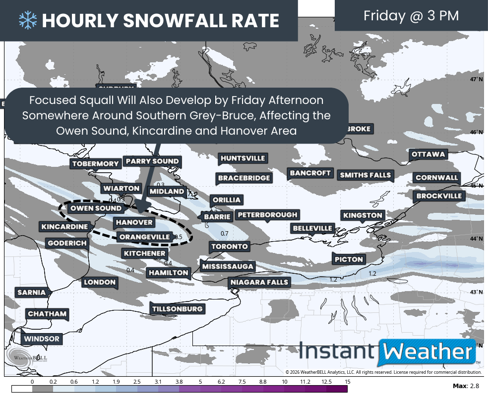
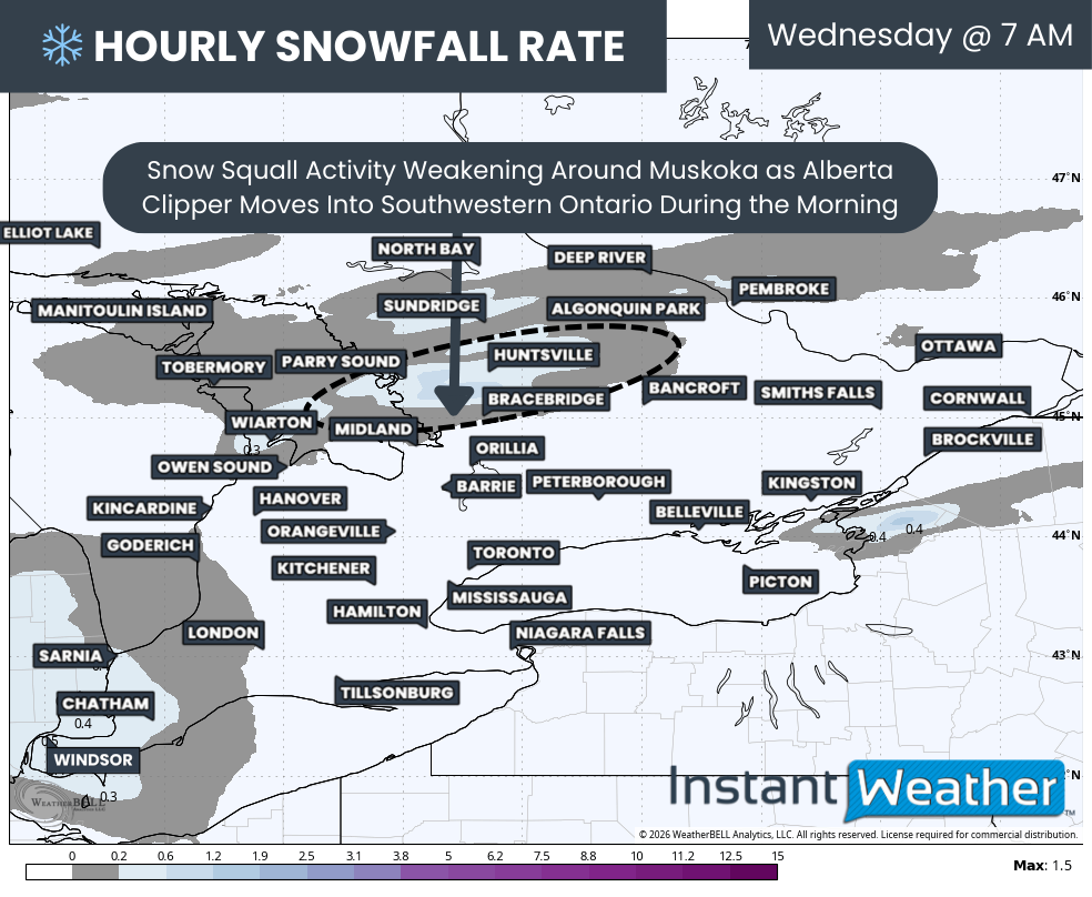
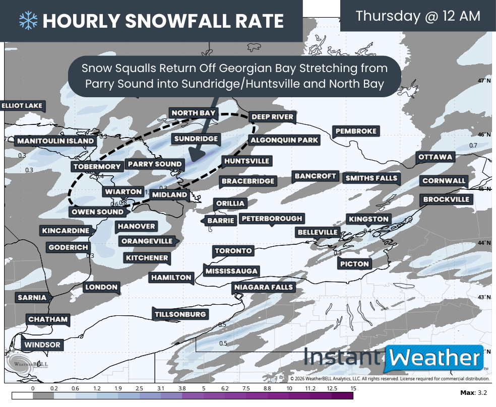
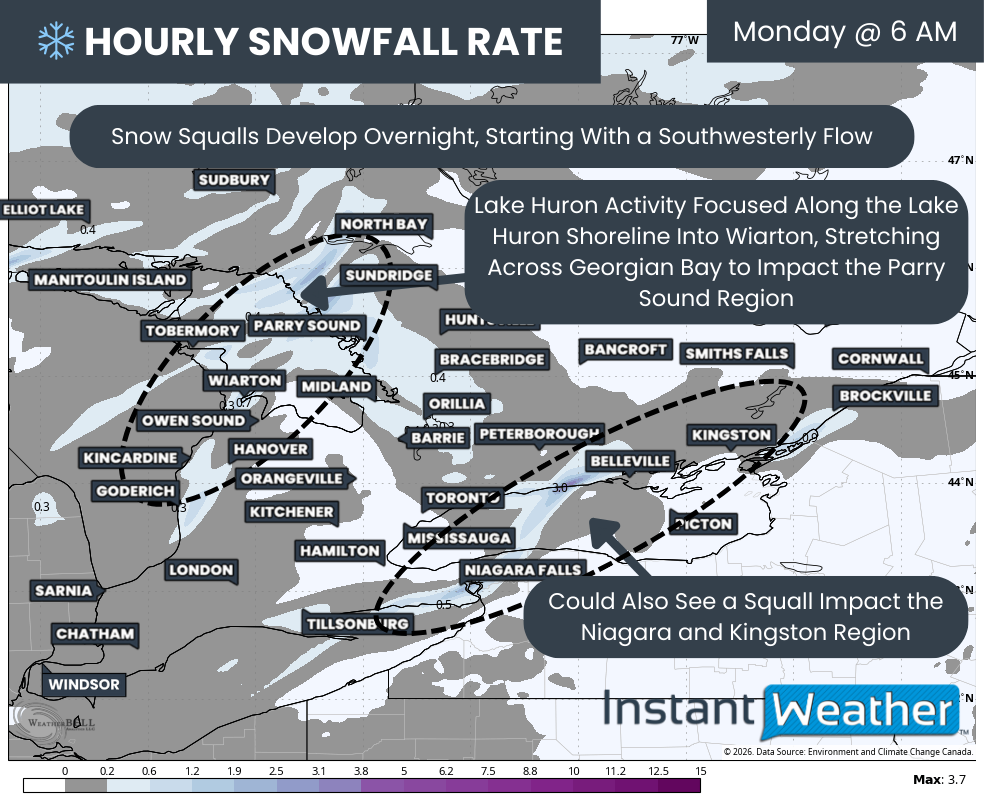
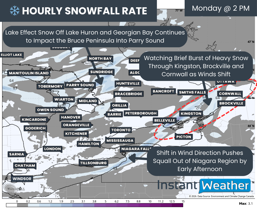
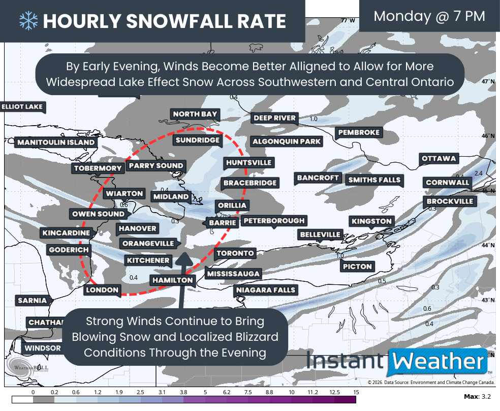
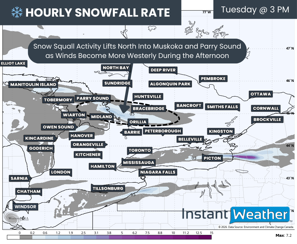
A shift in wind direction has caused snow squalls off Lake Huron and Georgian Bay to lift northward, pushing into the Bruce Peninsula and expanding into the Parry Sound and Muskoka regions.

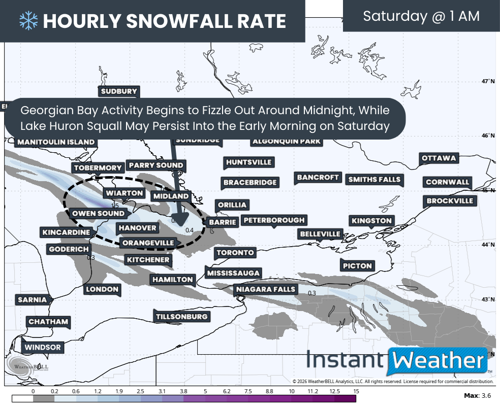
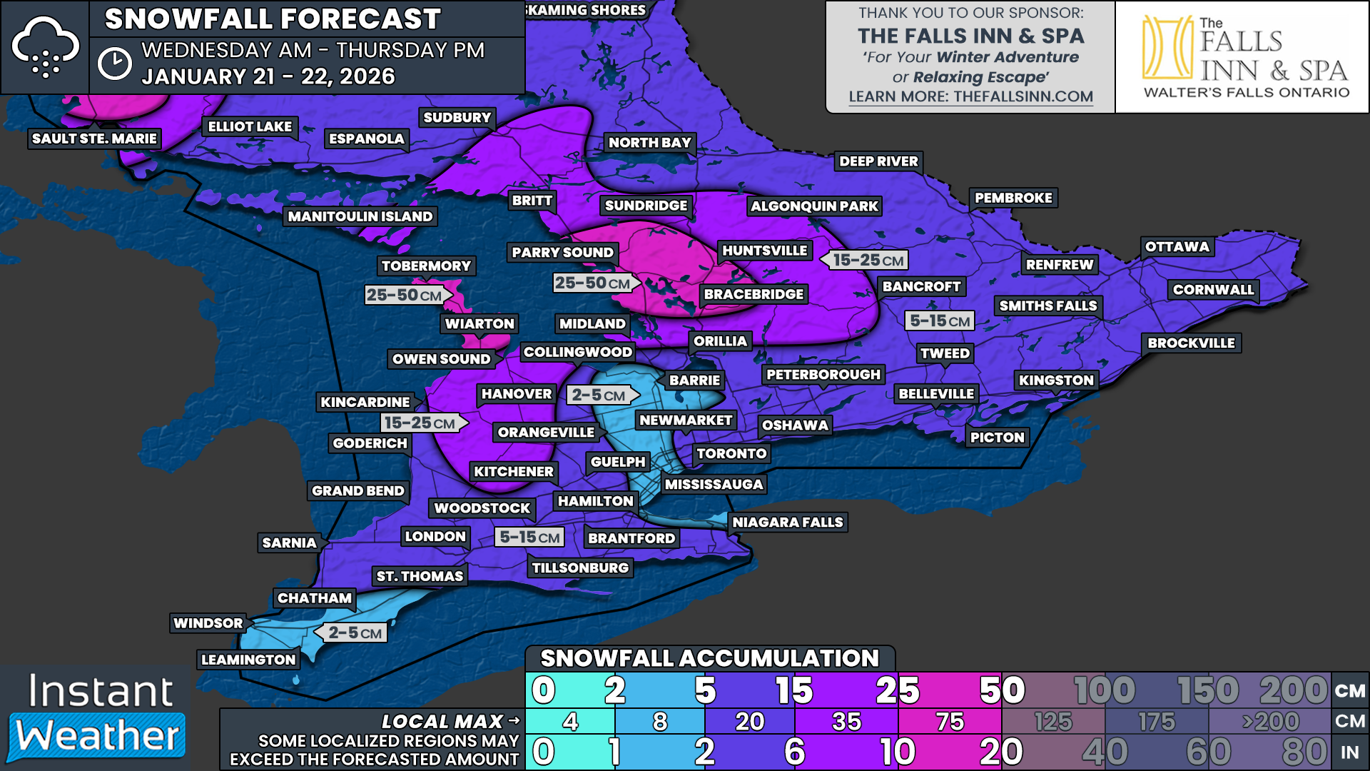
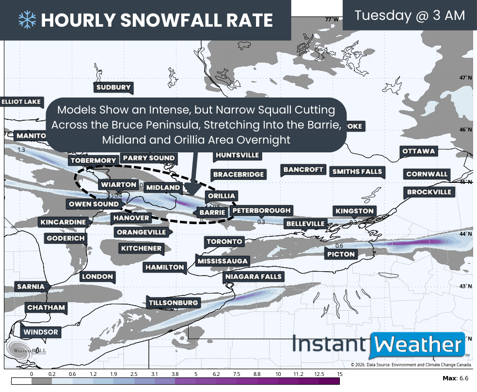
This lake effect snow is expected to persist overnight and into Wednesday morning, with locally significant snowfall totals possible. In the most intense and persistent bands, some communities could see an additional 30 to 50 cm of snow by the time this activity winds down.

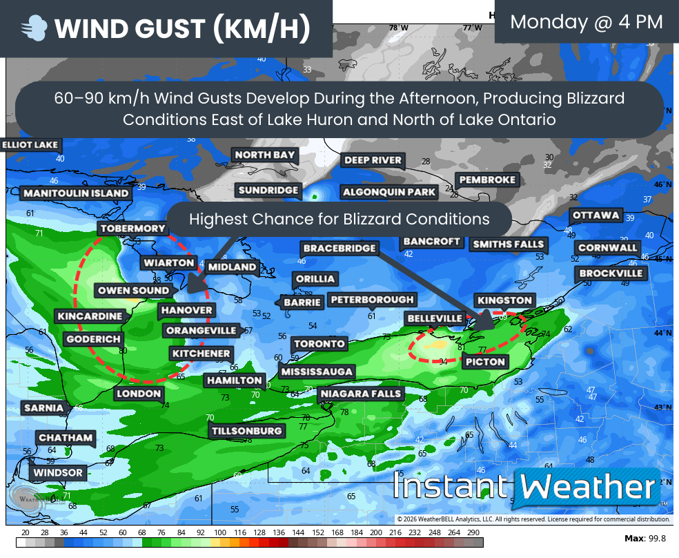
With snowfall of this magnitude falling over a relatively short period of time, travel conditions will deteriorate rapidly. Whiteout conditions, drifting snow and snow-covered rural routes will almost certainly keep school buses off the roads in the hardest hit areas on Wednesday.

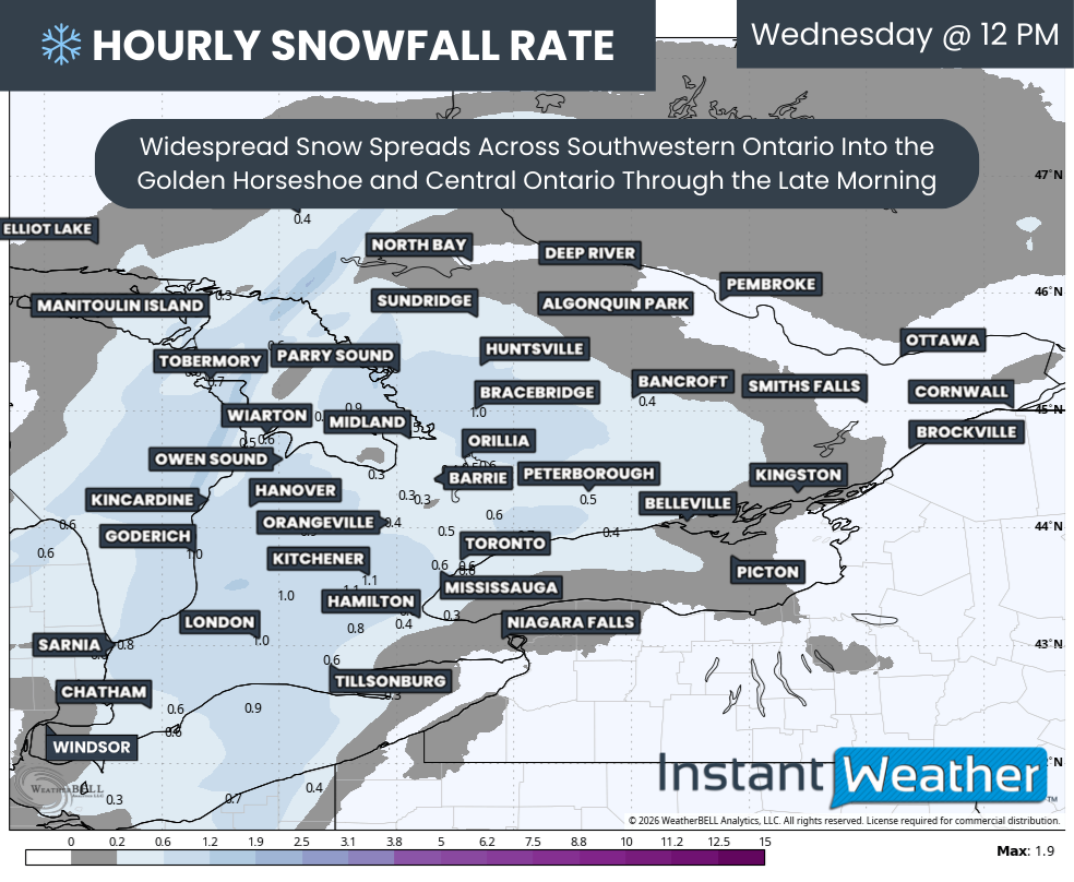
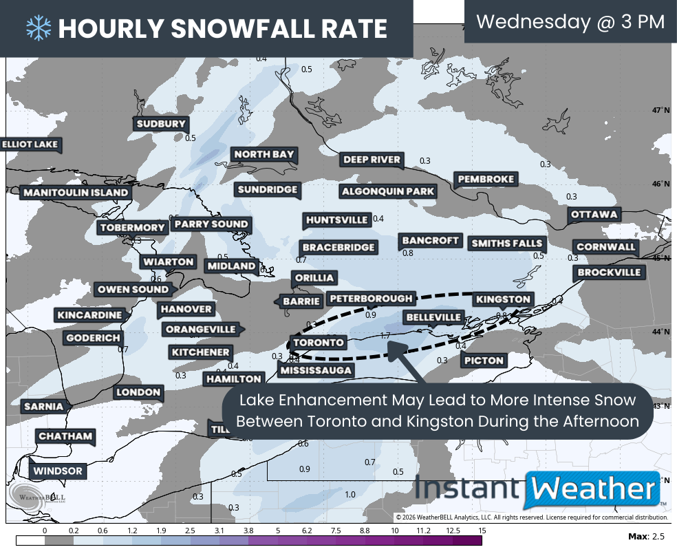
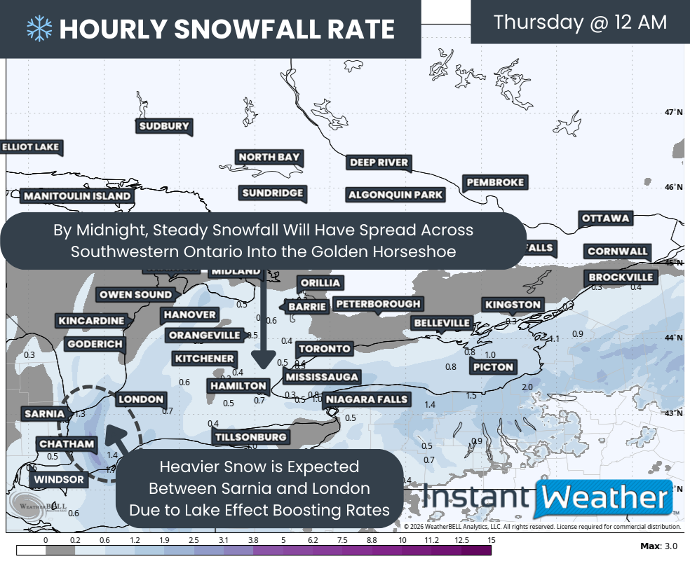
At the same time, attention will also be on a separate system moving in from the west. An Alberta Clipper is expected to slide through Southern Ontario beginning Wednesday morning and continue throughout much of the day. While this system is not expected to produce widespread heavy snowfall, most areas should still pick up several centimetres.

In some locations, lake enhancement could boost totals closer to 10 to 15 cm. With snow falling during the school day rather than overnight, this raises the possibility of scattered bus cancellations outside of the core snow squall zones.

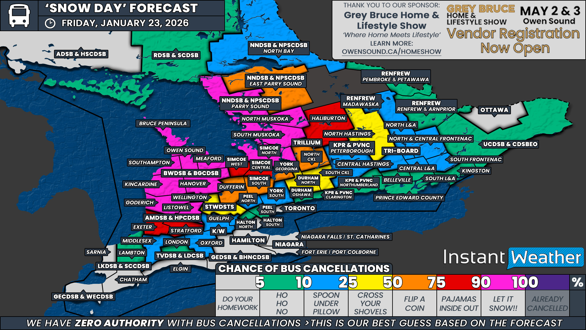
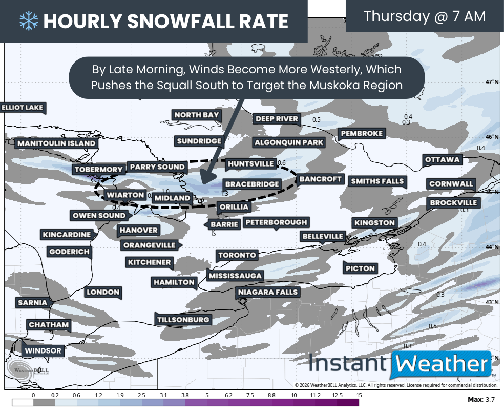
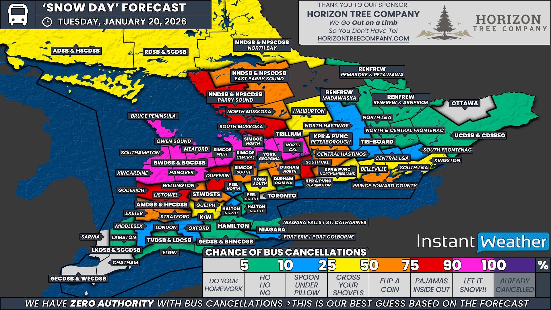
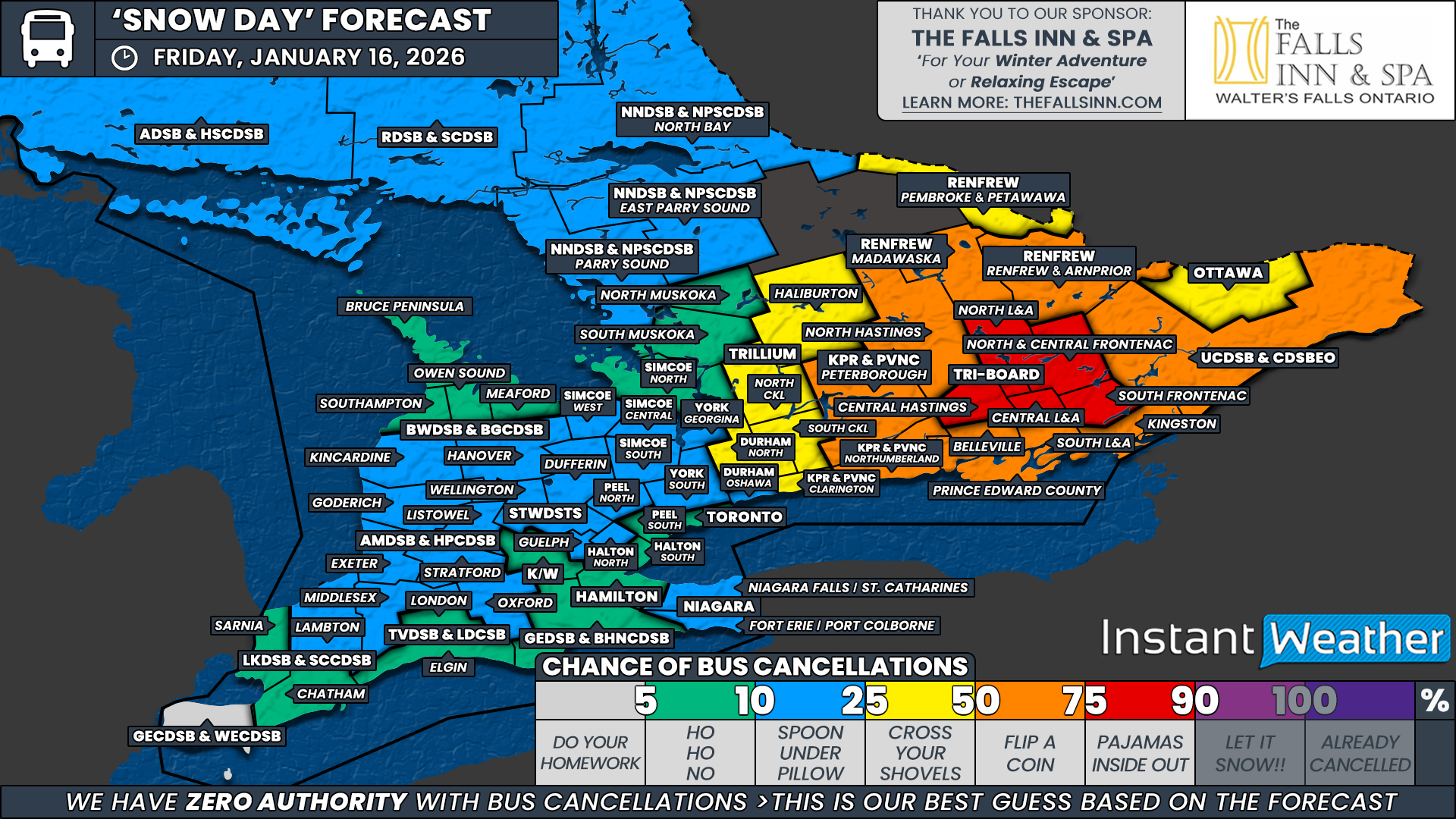
The highest confidence for a snow day remains in the areas directly impacted by the most intense lake effect activity. We have assigned a 90 percent chance to all regions of the Trillium Lakelands District School Board within Muskoka, the Parry Sound region under the Near North District School Board, and the Bruce Peninsula within the Bluewater District School Board.

In these areas, snow squalls are expected to remain relentless through Wednesday morning, making travel extremely hazardous. Impacts will be very localized, and once you move outside of these zones, probabilities drop quickly.

Immediately surrounding the core squall region, we have a 50 percent chance for East Parry Sound under the Near North District School Board. Conditions here will be highly dependent on how far north and east the strongest squalls extend overnight.

We have also assigned a 25 percent chance to the remainder of the Simcoe County District School Board, the rest of the Trillium Lakelands District School Board and North Bay under the Near North District School Board.

In these areas, cancellations are questionable but cannot be ruled out if lake effect snow pushes farther inland than expected.

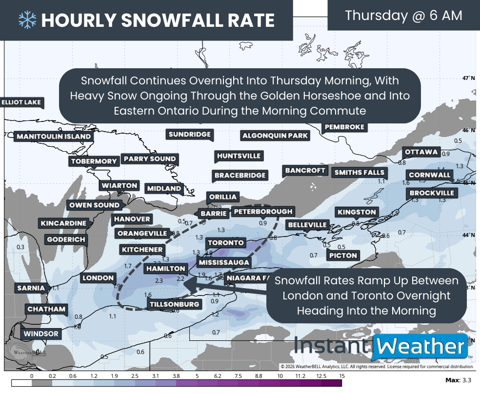
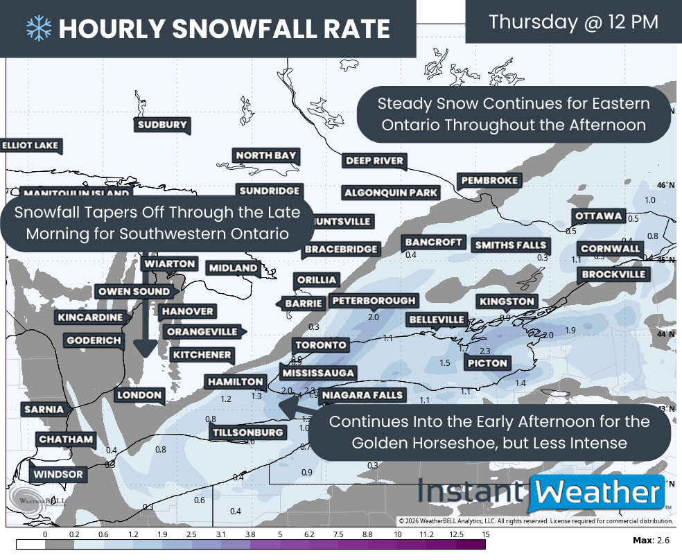
For impacts tied to the Alberta Clipper, our highest confidence is focused on Southwestern Ontario. Snow will arrive earlier in the day here, increasing the likelihood of cancellations when snowfall is actively occurring rather than forecasted for later when the decision is made in the morning.

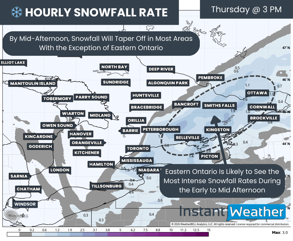
Confidence is also higher across parts of Eastern Ontario along the Lake Ontario shoreline, where snowfall warnings are already in effect, and these school boards tend to be more proactive when poor afternoon conditions are expected.

A strong likelihood zone, with a 75 percent chance of a snow day, includes the remainder of the Bluewater District School Board outside the Bruce Peninsula, all regions covered by the Avon Maitland District School Board, Northumberland County under the Kawartha Pine Ridge District School Board, and Belleville, Prince Edward County, South Lennox and Addington, South Frontenac and Kingston within Tri-Board Student Transportation Services. In these regions, we expect many boards to opt for cancellations as conditions deteriorate through the day.

Across Deep Southwestern Ontario, we have assigned a 50 percent chance to all regions of the Lambton Kent District School Board and the Greater Essex County District School Board. Snow is expected to be falling during the decision-making window on Wednesday morning, and even without active warnings, snowfall combined with gusty winds could be enough to prompt cancellations.

This 50 percent zone also extends into Middlesex and Oxford counties under the Thames Valley District School Board, as well as Wellington and Dufferin counties within the Upper Grand District School Board, where snowfall warnings are in effect and could justify proactive cancellations even if snow begins later in the morning.

In Eastern Ontario, we have also assigned a 50 percent chance to Central Hastings, Central Lennox and Addington, and North and Central Frontenac within Tri-Board Student Transportation Services, along with Clarington under the Kawartha Pine Ridge District School Board. Here, outcomes will depend heavily on snowfall rates and timing, with some areas potentially seeing enough accumulation during the day to warrant cancellations.

Once you move into more urban school boards across Southwestern Ontario and around the Golden Horseshoe, confidence drops further. We have given a 25 percent chance to London and Elgin County under the Thames Valley District School Board, the Grand Erie District School Board, the Waterloo Region District School Board, Guelph within the Upper Grand District School Board, Georgina under the York Region District School Board and Durham Region.

While some of these areas are included in snowfall warnings, the forecasted amounts may fall just short of the higher thresholds typically required for cancellations. Elgin County, while not urban, is not currently under a snowfall warning, which is why it is lumped into the 25% chance.

Farther east, a 25 percent chance has also been assigned to Peterborough County under the Kawartha Pine Ridge District School Board, North Frontenac within Tri-Board Student Transportation Services, and the Madawaska region under the Renfrew County District School Board. These areas are not currently under active warnings, and snow is expected to arrive later in the morning. However, if school boards opt for system-wide cancellations rather than region-specific decisions, a few surprises remain possible.

For the more urban school boards across the Greater Toronto Area, the chance of a snow day remains low to very low. Snowfall amounts are not expected to reach the high threshold these regions typically require for cancellations.

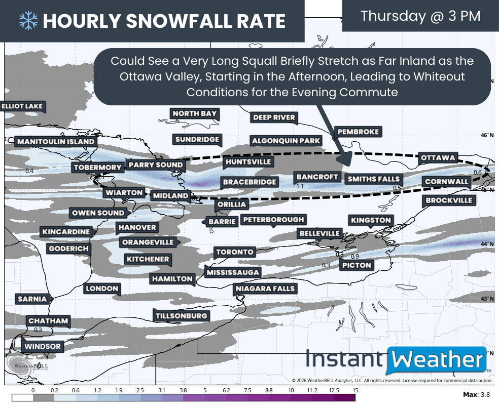
In the Ottawa Valley, snowfall is expected to be limited and delayed until the middle of the afternoon. Because of this timing and lower expected totals, school bus cancellations are not anticipated in this region on Wednesday.


Disclaimer: Instant Weather has zero authority when it comes to bus and school closures.

It is completely up to the school boards, bus companies, local authorities, and parents to decide what is best for their children. This is our best guess based on our forecast.

Southern Ontario: School Bus Cancellations and Closures for Tuesday, January 20, 2026

**Please refresh your page every few minutes to receive the latest update**

Cancellation & Closure Map (English Public and Catholic Schools)

Please note: School board boundaries are a rough estimate. Don’t use this map to determine what school board or weather zone you live in as accuracy isn’t guaranteed.

  • Green = No Cancellations

  • Red = Cancellations (Click for More Details)

  • Purple = School Closures (Click for More Details)

List of Cancellations & Closures

English Public and Catholic Schools

  • Avon MaitIand Public & Huron-Perth CathoIic: There are several closures/cancellations, please visit this link for more details: https://hpsts.mybusplanner.ca/Alerts

  • BIuewater Public & Bruce-Grey Catholic: All busses are cancelled. All schools are now closed.

  • Dufferin-PeeI Catholic: Buses to St. Andrew, St. Peter, St. Benedict, and Dufferin County buses to Robert F. Hall CSS are cancelled today

  • Near North Public & Nipissing-Parry Sound CathoIic: School Bussing is cancelled in the Weather Zones of West Parry Sound and East Parry Sound South

  • Simcoe County Public & Simcoe Catholic: Busses are cancelled for the North, West, and Central Zones.

  • Upper Grand Public & Wellington CathoIic: All school taxis and buses in Division 2 (Centre Wellington), Division 3 (North Wellington), and Division 4 (Dufferin County) will not be operating today.

French Schools

  • Conseil catholique MonAvenir: Busses are cancelled for some schools in Wellington and Simcoe

  • Conseil scolaire catholique Providence: Busses are cancelled in Huron Perth, Simcoe (North, West, and Central Zones), and Bruce-Grey

  • Conseil scolaire Viamonde: Busses are cancelled in Huron Perth, Simcoe (North, West, and Central Zones), and Bruce-Grey

  • Le Conseil scolaire public du Nord-Est de l’Ontario (CSPNE) & Conseil scolaire catholique Franco-Nord: School Bussing is cancelled in the Weather Zones of West Parry Sound and East Parry Sound South

‘Snow Day’ Forecast: Ongoing Snow Squall Activity in Southern Ontario Likely to Cancel School Buses on Tuesday in Some Areas

For an updated list of school bus cancellations & school closures, please visit our live article: https://instantweatherinc.com/article/2026/1/20/bus-cancellations

NOTE: YOU CAN CLICK ON THE MAP TO OPEN A ZOOMABLE IMAGE

As expected, snow squall activity has been hammering the traditional snowbelt regions around Lake Huron and Georgian Bay throughout the day on Monday. This has already led to widespread school bus cancellations and even a handful of school closures in the hardest hit areas. With this lake effect activity expected to persist into Tuesday, it is becoming increasingly clear that some students will be waking up to their second snow day of the week.

Overnight, attention will turn to a particularly intense snow squall that is forecast to stretch across the Bruce Peninsula and then push southeast of Georgian Bay. This includes parts of Simcoe County, southern Muskoka, the Kawartha Lakes region and potentially as far east as Peterborough. At the same time, additional lake effect activity off Lake Huron is expected to continue impacting Huron and Perth counties, keeping snowfall rates elevated through the night and into Tuesday morning.

In addition to the snow, very cold Arctic air will remain firmly in place. Wind chills overnight into Tuesday morning are expected to drop sharply, with parts of Northern and Central Ontario potentially seeing wind chills as low as minus 35 to minus 40. In a few of the more northern and rural school boards, this may be cold enough to raise concerns about cold-related cancellations on top of the ongoing snow squall impacts.

The strongest confidence for a snow day on Tuesday lies across all regions covered by the Bluewater District School Board, the Simcoe West and Simcoe North weather zones under the Simcoe County District School Board, and the northern Kawartha Lakes region within the Trillium Lakelands District School Board.

These areas sit directly within the core of the most persistent snow squall activity and are very likely to see dangerous travel conditions during the morning bus run. As a result, we have assigned these regions a 90 percent chance of a snow day, with school closures even being a possibility in some communities.

A second tier of regions carries a strong likelihood, with a 75 percent chance of bus cancellations. This includes northern portions of Huron and Perth counties under the Avon Maitland District School Board, Dufferin County within the Upper Grand District School Board, the Simcoe Central weather zone, South Kawartha Lakes and South Muskoka under the Trillium Lakelands District School Board, and the Parry Sound region within the Near North District School Board. In these areas, we are leaning toward cancellations, but confidence is slightly lower than in the core snowbelt due to some uncertainty in squall placement and intensity.

In the toss-up category, where outcomes could genuinely go either way, we have included southern Huron and southern Perth counties under the Avon Maitland District School Board, Wellington County for the Upper Grand District School Board, the Simcoe South weather zone, Georgina within the York Region District School Board, the northern portion of the Durham District School Board, North Muskoka under the Trillium Lakelands District School Board, East Parry Sound within the Near North District School Board, Peterborough County under the Kawartha Pine Ridge District School Board, and Prince Edward County within Tri-Board Student Transportation Services. These areas are either positioned just outside the most intense squall bands or are covered by school boards that typically maintain a higher threshold for cancellations.

A slight chance, around 25 percent, has been assigned to a number of additional regions. This includes the Waterloo Region District School Board, Guelph within the Upper Grand District School Board, the southern York Region District School Board weather zone, Haliburton under the Trillium Lakelands District School Board, Northumberland County within the Kawartha Pine Ridge District School Board, and Belleville, South Lennox and Addington, and Kingston under Tri-Board Student Transportation Services.

We have also included a slight chance for North Bay within the Near North District School Board and areas covered by the Rainbow District School Board. In these northern regions, the concern shifts more toward extreme cold, though confidence is lower on whether temperatures will reach the threshold required for cold-related cancellations.

For the rest of Southern Ontario, the risk of a snow day on Tuesday drops to low or very low. This includes most urban school boards across the Golden Horseshoe, the London area, Deep Southwestern Ontario and the Ottawa Valley. These regions are not expected to see significant impacts from the lake effect snow, and travel conditions should remain manageable enough for buses to operate as normal.


Disclaimer: Instant Weather has zero authority when it comes to bus and school closures.

It is completely up to the school boards, bus companies, local authorities, and parents to decide what is best for their children. This is our best guess based on our forecast.

Southern Ontario: School Bus Cancellations and Closures for Monday, January 19, 2026

**Please refresh your page every few minutes to receive the latest update**

Cancellation & Closure Map (English Public and Catholic Schools)

Please note: School board boundaries are a rough estimate. Don’t use this map to determine what school board or weather zone you live in as accuracy isn’t guaranteed.

  • Green = No Cancellations

  • Red = Cancellations (Click for More Details)

  • Purple = School Closures (Click for More Details)

List of Cancellations & Closures

English Public and Catholic Schools

  • Avon MaitIand Public & Huron-Perth CathoIic: There are several closures/cancellations, please visit this link for more details: https://hpsts.mybusplanner.ca/Alerts

  • BIuewater Public & Bruce-Grey Catholic: All busses are cancelled and schools are closed.

  • Dufferin-PeeI Catholic: Buses to St. Andrew, St. Peter, St. Benedict, and Dufferin County buses to Robert F. Hall CSS are cancelled today

  • Kawartha Pine Ridge Public & Peterborough Victoria Northumberland Clarington Catholic: Transportation is cancelled in Northumberland County today.

  • Near North Public & Nipissing-Parry Sound CathoIic: School Bussing is cancelled in the Weather Zones of West Parry Sound, East Parry Sound South, West Nipissing, and Redbridge/Thorne.

  • Niagara Public & Niagara Catholic: Transportation is cancelled today for all schools in south Niagara (Fort Erie, Port Colborne and Wainfleet). There will be no late activity bus service for Niagara Falls, Welland, Fort Erie, Port Colborne and Wainfleet this evening.

  • Simcoe County Public & Simcoe Catholic: Busses are cancelled in the North Zone.

  • Tri-Board: Transportation is cancelled in the Centre Hastings, Belleville & Quinte West, Prince Edward County, Central and South Lennox & Addington, South Frontenac and Kingston area weather zones today. Schools are closed in Prince Edward County.

  • Upper Grand Public & Wellington CathoIic: All school taxis and buses in Division 2 (Centre Wellington), Division 3 (North Wellington), and Division 4 (Dufferin County) will not be operating today. Schools in Zone 3 are closed.

French Schools

  • Conseil des écoles publiques de l’Est de l’Ontario (CEPEO): Busses are cancelled for Kingston and Trenton

  • Conseil catholique MonAvenir: Some busses are cancelled for schools in Durham, Simcoe, Peterborough, and Niagara

  • Conseil scolaire de district catholique de l'Est Ontarien (CSDCEO): Busses are cancelled for Kingston and Trenton

  • Conseil des écoles catholiques de langue française du Centre-Est: Busses are cancelled for Kingston and Trenton

  • Conseil scolaire catholique Providence: Busses are cancelled for Huron Perth, Simcoe North, Niagara South, and Bruce-Grey

  • Conseil scolaire Viamonde: Busses are cancelled for Huron Perth, Simcoe North, Niagara South, and Bruce-Grey

  • Le Conseil scolaire public du Nord-Est de l’Ontario (CSPNE) & Conseil scolaire catholique Franco-Nord: School Bussing is cancelled in the Weather Zones of West Parry Sound, East Parry Sound South, West Nipissing, and Redbridge/Thorne.

Southern Ontario Plunges Into the Deep Freeze With Dangerous Blizzard Conditions on Monday

NOTE: YOU CAN CLICK ON THE MAP TO OPEN A ZOOMABLE IMAGE

That January thaw is now firmly in the rearview mirror across Southern Ontario after a major winter storm last week reminded us that we are still very much in the heart of winter. That storm brought widespread snowfall to the region, with many areas picking up significant accumulations and some seeing totals in the 30 to 50 cm range by the time it wrapped up on Thursday.

While we are not expecting another large, widespread system-related snowstorm of that magnitude in the immediate future, the pattern is far from quiet. In fact, the bigger story going forward will be a prolonged stretch of much colder weather as we head deeper into January. A true deep freeze is set to take hold beginning early this upcoming week and is expected to persist for much of the remainder of the month.

With temperatures plunging and the Great Lakes still largely ice-free, the setup becomes ideal for an active period of lake effect snow. Cold polar air moving over relatively warm lake waters is the perfect fuel source for snow squalls, and that lake effect snow machine is about to kick into high gear.

Ironically, this could end up being one of the last notable lake effect events of the season, as colder temperatures later this month will eventually lead to increasing ice coverage. Once the lakes begin to freeze over, the moisture supply is cut off, and snow squalls shut down. For now, though, the lakes are open and very capable of producing heavy snow.

That lake effect machine is expected to come roaring to life starting on Monday. By the time activity winds down late Tuesday, some communities could be digging out from substantial snowfall. Totals of 25 to 50 cm are possible in parts of Grey Bruce, Simcoe County and areas north of Parry Sound, although, as always with lake effect snow, not everyone will see those kinds of amounts.

Snow squall activity is expected to begin organizing overnight into Monday morning along the eastern Lake Huron shoreline. This activity will expand throughout the morning, affecting Grey Bruce, the Bruce Peninsula, and regions northeast of Georgian Bay. Additional lake effect bands are also expected to develop off Lakes Erie and Ontario, impacting parts of the Niagara region and Prince Edward County as early as Monday morning.

Conditions will deteriorate quickly on Monday afternoon as strong winds develop across much of Southern Ontario. Wind gusts of 60 to 90 km per hour are expected, and when combined with ongoing snow squalls, this could lead to dangerous blizzard conditions, particularly east of Lake Huron and in Prince Edward County.

The worst conditions are expected during the afternoon and early evening hours, with blowing snow and near zero visibility at times. There is also some concern that blowing snow could briefly impact parts of the Golden Horseshoe around the evening commute.

Through Monday night and into Tuesday morning, attention shifts toward a potentially intense and long-lasting snow squall. This band may set up across the Bruce Peninsula, extend across Georgian Bay, and come ashore into Simcoe County and possibly the Kawartha Lakes.

Some models suggest this squall could lock into place for 6 to 12 hours before finally lifting northward by Tuesday afternoon. Where it becomes stationary, snowfall rates could be intense, and accumulations could climb rapidly in a short period of time.

Adding to the concern will be the arrival of bitterly cold air late Monday. Temperatures will fall sharply, and by Tuesday morning, wind chills could make it feel like minus 20 degrees or colder across much of Southern Ontario. In some areas, wind chills could dip even lower.

When combined with heavy snow and strong winds, conditions could quickly become life-threatening for anyone who becomes stranded. Travel is strongly discouraged in the hardest hit regions beginning late Monday morning and continuing through Tuesday.

Hourly snowfall rates (cm) - MAP FROM WEATHERBELL

Lake effect snow will continue to organize overnight into Monday morning along Lake Huron, particularly around Grey Bruce. Bands will extend across the Bruce Peninsula and into areas northeast of Georgian Bay, including Parry Sound and even as far inland as North Bay at times.

While there is still some disagreement in the models regarding exact intensity, confidence is high enough to expect very poor driving conditions due to blowing snow and rapidly changing visibility, especially northeast of Georgian Bay, where the strongest bands are most likely.

There is also a more uncertain, but still concerning, snow squall signal for the Niagara region and the northeastern shoreline of Lake Ontario. The Canadian model shows a well-organized band coming off Lake Erie, moving across the Niagara region, then redeveloping over Lake Ontario and making landfall again across Prince Edward County and into the Kingston area. Other models are less aggressive with this scenario, particularly with the Lake Erie component, but there is better agreement that the Lake Ontario squalls will develop.

If this scenario plays out, it could lead to poor conditions and brief whiteouts during the Monday morning commute in parts of Niagara, as well as along portions of the Highway 401 corridor between Oshawa and Kingston.

Hourly snowfall rates (cm) - MAP FROM WEATHERBELL

By Monday afternoon, lake effect activity is expected to persist across Grey Bruce and areas northeast of Georgian Bay, although shifting winds may cause bands to weaken and reorganize at times. In the Niagara region, any squall activity should gradually sink south and east into upstate New York, with Niagara Falls and Fort Erie likely among the last locations to see conditions improve.

As winds shift, there is also a risk that a narrow but intense squall could sweep through Eastern Ontario during the afternoon, affecting areas such as Kingston, Brockville and Cornwall with sudden bursts of heavy snow and near zero visibility.

WIND GUST - MAP FROM WEATHERBELL

For many areas on Monday, the main impact may not be total snowfall amounts, but rather the combination of strong winds and blowing snow. Wind gusts of 60 to 90 km per hour across Southwestern Ontario and the Golden Horseshoe will make travel extremely difficult in open areas. East of Lake Huron, widespread road closures are very likely through the afternoon and early evening hours as conditions become too dangerous for travel.

Prince Edward County is also at risk of blizzard conditions if snow squalls persist there through the afternoon. Even modest snowfall rates can create severe conditions when combined with strong winds and exposed roadways.

Winds are expected to ease slightly on Monday evening, but blowing snow may continue overnight wherever squalls remain active.

Hourly snowfall rates (cm) - MAP FROM WEATHERBELL

As wind direction becomes better aligned during the evening, lake effect snow off Lake Huron may push further inland. This could allow poor visibility and blowing snow to extend into areas such as Kitchener, Barrie, Muskoka and the northern GTA around the dinner hour.

Hourly snowfall rates (cm) - MAP FROM WEATHERBELL

Confidence continues to increase for a more prolific snow squall to set up overnight Monday into Tuesday. This band may stretch across the Bruce Peninsula and move ashore from Georgian Bay into areas such as Midland, Barrie and Orillia. At times, it could reach far inland, potentially impacting the Kawartha Lakes and even the Peterborough area.

There is still some uncertainty regarding the exact placement. Some models focus the heaviest snowfall over northern Simcoe County, including Midland and Orillia, while others bring the core of the squall closer to Barrie. Regardless of exact placement, this squall could persist through Tuesday morning, remaining nearly stationary for several hours. Snowfall rates in the heaviest pockets could approach 10 cm per hour, which would lead to significant accumulations in a short amount of time.

WIND CHILL - MAP FROM WEATHERBELL

What makes this setup particularly dangerous is what it will be accompanied by at the same time. This intense snow squall is expected to coincide with bitterly cold temperatures. Wind chills will drop into the minus 20s and even minus 30s in some areas starting Monday evening and continuing overnight into Tuesday morning. In these conditions, frostbite and hypothermia can develop very quickly, sometimes in just minutes.

If someone becomes stranded during one of these squalls, the situation can become life-threatening rapidly. Emergency services may struggle to reach those in need due to road closures and near-zero visibility, and snowplows simply cannot keep up with snowfall rates of 5 to 10 cm per hour. This is why staying off the roads in affected regions is strongly advised.

Hourly snowfall rates (cm) - MAP FROM WEATHERBELL

By Tuesday afternoon, the most persistent squall should lift north of Simcoe County and move into Muskoka and Parry Sound. The band may briefly reorganize Tuesday night ahead of another potential system arriving on Wednesday.

That system on Wednesday could bring a more widespread snowfall of around 5 to 15 cm across much of Southern Ontario. More details on that will be shared in a separate forecast closer to midweek.

NOTE: YOU CAN CLICK ON THE MAP TO OPEN A ZOOMABLE IMAGE

When it comes to snowfall totals from this lake effect event, it is important to remember how localized these squalls can be. Accumulations can vary dramatically over short distances depending on where bands set up, how long they persist, and whether they wobble or remain stationary.

Our forecast highlights areas most at risk for higher totals, but not everyone within those zones will see the same amounts, and some locations could overperform if a band shifts unexpectedly.

The highest snowfall totals are most likely across Grey Bruce, particularly the Bruce Peninsula, where 25 to 50 cm of snow is possible. Areas on the peninsula are more likely to reach the upper end of that range, while locations farther south, such as Hanover and Flesherton, may be closer to 25 cm or could even fall short if bands stay to the north.

A similar 25 to 50 cm potential exists southeast of Georgian Bay, including Midland, Wasaga Beach, Barrie, Orillia, Washago and Beaverton. Areas northeast of Georgian Bay, north of Parry Sound, including Pointe au Baril and Britt, are also within this higher snowfall zone.

Amounts of 15 to 25 cm are expected for places such as Goderich, Point Clark, Wingham, Listowel, Minto, Shelburne, Lindsay, Fenelon Falls, Coboconk, Gravenhurst and Parry Sound.

NOTE: YOU CAN CLICK ON THE MAP TO OPEN A ZOOMABLE IMAGE

Along the Lake Ontario shoreline, areas northeast of the lake, including Brighton, Belleville, Picton, Napanee and Kingston could also see 15 to 25 cm, with locally higher totals possible in spots like Picton if a band locks in.

The Niagara region, including Fort Erie, Niagara Falls, Niagara on the Lake, St. Catharines and Welland, is looking at generally 5 to 15 cm. Most locations will likely be closer to the lower end of that range, with Niagara Falls and Fort Erie having the best chance of seeing higher totals if a squall sets up nearby.

Elsewhere, including Woodstock, Kitchener, Fergus, Guelph, Orangeville, Keswick, Port Perry, Peterborough, Bracebridge, Huntsville, Haliburton, Cobourg and Brockville, totals of 5 to 15 cm are possible. Many of these areas will end up closer to 5 cm, but isolated locations could see higher amounts depending on how lake effect bands evolve.

For the GTA, London, deep Southwestern Ontario and the Ottawa Valley, snowfall amounts are expected to remain under 5 cm, although gusty winds and blowing snow may still impact travel at times.

‘Snow Day’ Forecast: Monday’s Blizzard Risk Expected to Result in Widespread School Bus Cancellations in Southern Ontario

For an updated list of school bus cancellations & school closures, please visit our live article: https://instantweatherinc.com/article/2026/1/19/bus-cancellations

NOTE: YOU CAN CLICK ON THE MAP TO OPEN A ZOOMABLE IMAGE

Intense snow squall activity, combined with bitterly cold wind chills and strong, gusty winds, is expected to create dangerous blizzard conditions across snowbelt regions near Lake Huron, Georgian Bay, Lake Ontario and Lake Erie on Monday.

Environment Canada has issued a range of winter weather alerts in response to this setup, including a strongly worded orange-level blizzard warning for areas east of Lake Huron as well as Prince Edward County. In these regions, wind gusts of 70 to 90 km/h combined with snowfall totals of 20 to 40 cm are expected to lead to near-zero visibility and extremely hazardous travel conditions.

With warnings of this severity in place, it is difficult to see how school buses could operate safely in the hardest hit areas. Blizzard conditions of this nature pose a significant safety risk for anyone on the roads, particularly during the afternoon hours when conditions are expected to be at their worst.

Because of this, we have near certainty of a snow day in several regions. A 90 percent chance of school bus cancellations has been assigned to all areas covered by the Bluewater District School Board and the Avon Maitland District School Board, along with Wellington County under the Upper Grand District School Board and Prince Edward County within Tri-Board Student Transportation Services. These regions sit directly within the blizzard warning area, where travel is expected to be extremely dangerous.

While not under the blizzard warning itself, we have also assigned a 90 percent chance to the Parry Sound region within the Near North District School Board, as well as Belleville and South Lennox and Addington under Tri-Board Student Transportation Services. These areas remain under snow squall warnings, which on their own are typically more than enough to prompt cancellations. Given the expected intensity and duration of the squalls, cancellations here appear highly likely.

A strong likelihood zone, with a 75 percent chance of a snow day, includes Kingston under Tri-Board, Northumberland County within the Kawartha Pine Ridge District School Board, the southern Niagara Region under the District School Board of Niagara, Dufferin County within the Upper Grand District School Board, the Simcoe West weather zone under the Simcoe County District School Board, North Muskoka under the Trillium Lakelands District School Board, East Parry Sound within the Near North District School Board, and all areas covered by the Rainbow District School Board. We are leaning toward cancellations in most of these regions, although some fall within boards that tend to be stricter with snow day decisions or sit just outside the most intense squall bands.

The probability drops off fairly quickly once you move outside the core snow squall risk zone, as lake effect impacts will be highly localized. In the toss-up category, where there is a 50 percent chance of a snow day, we have included the northern Niagara Region under the District School Board of Niagara, the Grand Erie District School Board, the Waterloo Region District School Board, Guelph within the Upper Grand District School Board, Clarington under the Kawartha Pine Ridge District School Board, the Simcoe Central and Simcoe North weather zones, South Muskoka under the Trillium Lakelands District School Board, and North Bay within the Near North District School Board.

A slight chance, around 25 percent, has been assigned to Middlesex and Oxford counties under the Thames Valley District School Board, northern Peel Region, the Simcoe South weather zone, Haliburton and North Kawartha Lakes within the Trillium Lakelands District School Board, Peterborough County under the Kawartha Pine Ridge District School Board, and Central Hastings, Central Lennox and Addington, and South Frontenac under Tri-Board Student Transportation Services. These regions are not currently under active warnings but remain close enough to the snow squall zones that a surprise cancellation cannot be ruled out if Environment Canada expands alert areas by Monday morning.

For the remainder of Southern Ontario, including Deep Southwestern Ontario, much of the Greater Toronto Area and the Ottawa Valley, the chance of a snow day remains low to very low. These regions are not expected to see significant impacts from lake effect snow, and travel conditions should remain manageable enough for school buses to operate as normal.


Disclaimer: Instant Weather has zero authority when it comes to bus and school closures.

It is completely up to the school boards, bus companies, local authorities, and parents to decide what is best for their children. This is our best guess based on our forecast.

Southern Ontario: School Bus Cancellations and Closures for Friday, January 16, 2026

**Please refresh your page every few minutes to receive the latest update**

Cancellation & Closure Map (English Public and Catholic Schools)

Please note: School board boundaries are a rough estimate. Don’t use this map to determine what school board or weather zone you live in as accuracy isn’t guaranteed.

  • Green = No Cancellations

  • Red = Cancellations (Click for More Details)

  • Purple = School Closures (Click for More Details)

List of Cancellations & Closures

English Public and Catholic Schools

  • Lambton Kent Public & St. CIair Catholic: Busses in Zones 1, 3, & 4 are cancelled.

  • Renfrew County Public & Renfrew County Catholic: Zone 4 Madawaska area transportation services ONLY are cancelled.

  • Tri-Board: Transportation is cancelled in North Hastings, North, Central and South Lennox & Addington, North& Central and South Frontenac and Kingston area weather zones.

  • Upper Canada Public & Eastern Ontario CathoIic: All transportation is cancelled.

French Schools

  • Conseil des écoles publiques de l’Est de l’Ontario (CEPEO): All CTSE busses are cancelled

  • Conseil scolaire de district catholique de l'Est Ontarien (CSDCEO): All busses are cancelled

‘Snow Day’ Forecast: Snowstorm Aftermath May Cancel School Buses for a Second Day on Friday in Parts of Southern Ontario

For an updated list of school bus cancellations & school closures, please visit our live article: https://instantweatherinc.com/article/2026/1/16/bus-cancellations

NOTE: YOU CAN CLICK ON THE MAP TO OPEN A ZOOMABLE IMAGE

Many school buses were cancelled and even some schools were closed across Southern Ontario on Thursday as a high-impact snowstorm delivered widespread snowfall totals of 20 to 40 cm in some areas.

While the storm has begun to wind down heading into the evening, cleanup efforts are only just getting underway. With this amount of snow on the ground, it often takes more than a single night to fully dig out, especially on rural roads and backroads where plowing and treatment can take longer.

Because of this, we are expecting some lingering impacts for the Friday morning commute. The greatest concern lies across Eastern Ontario, where snowfall is only tapering off this evening. These areas will have significantly less time overnight to clear roads ahead of the morning bus run, increasing the likelihood of localized travel issues.

As a result, there is a chance that some school boards may opt for a second straight day of school bus cancellations on Friday. That said, this will be highly dependent on local road conditions and how effective overnight cleanup efforts are in each individual region.

Our highest confidence for additional cancellations is focused on the more rural zones within Tri-Board Student Transportation Services. This includes Central Hastings, North and Central Lennox and Addington, and North and Central Frontenac.

These areas rely heavily on rural bus routes that can remain snow-covered for longer periods following major storms. Because of this, we have assigned these regions a 75 percent chance of school bus cancellations on Friday.

Surrounding school boards with a heavy dependence on rural transportation are placed in the 50 percent category, where conditions could genuinely go either way. This includes areas covered by the Upper Canada District School Board, the Renfrew County District School Board, including the Renfrew and Madawaska regions, the remaining zones within Tri-Board, and Peterborough and Northumberland counties under the Kawartha Pine Ridge District School Board. In these regions, the final decision will likely come down to how quickly secondary roads can be cleared overnight.

For the Ottawa region, we have assigned a 25 percent chance. While Ottawa is more urban in nature and primary roads are expected to be in good shape by morning, the sheer volume of snow that fell may still present challenges on residential streets and bus routes. Whether that leads to cancellations remains uncertain.

A 25 percent chance has also been assigned to the Kawartha Lakes and Haliburton regions within the Trillium Lakelands District School Board, Clarington under the Kawartha Pine Ridge District School Board, and the northern portion of the Durham District School Board. These areas either lean more rural or did not see the most extreme snowfall totals from this storm. At this time, we are leaning toward buses running, but a few localized cancellations cannot be ruled out.

As you move farther west and north, confidence increases that roads will be in better shape by Friday morning. Snow tapered off earlier in the day in these areas, giving crews more time to clear routes. This includes a large portion of Southwestern Ontario as well as communities surrounding the Golden Horseshoe.

For these regions, we have gone with a widespread low to very low chance of school bus cancellations. No specific school board stands out as being particularly vulnerable, as outcomes will depend almost entirely on local road conditions. Boards covering more rural territory have been assigned closer to a 10 percent chance, while the more urban school boards across the Greater Toronto Area sit closer to 5 percent.

Across northern portions of Central Ontario, including areas covered by the Near North District School Board, the Rainbow District School Board and the Algoma District School Board, we have assigned a low 10 percent chance. Temperatures are expected to be very cold, but not cold enough to typically prompt cancellations on their own. Still, conditions are close enough to that threshold that a few isolated decisions cannot be completely ruled out.


Disclaimer: Instant Weather has zero authority when it comes to bus and school closures.

It is completely up to the school boards, bus companies, local authorities, and parents to decide what is best for their children. This is our best guess based on our forecast.

Southern Ontario: School Bus Cancellations and Closures for Thursday, January 15, 2026

**Please refresh your page every few minutes to receive the latest update**

Cancellation & Closure Map (English Public and Catholic Schools)

Please note: School board boundaries are a rough estimate. Don’t use this map to determine what school board or weather zone you live in as accuracy isn’t guaranteed.

  • Green = No Cancellations

  • Red = Cancellations (Click for More Details)

  • Purple = School Closures (Click for More Details)

List of Cancellations & Closures

English Public and Catholic Schools

  • Avon MaitIand Public & Huron-Perth CathoIic: All busses are cancelled and schools are closed.

  • BIuewater Public & Bruce-Grey Catholic: All busses are cancelled and schools are closed.

  • Dufferin-PeeI Catholic: All schools and offices/facilities are closed.

  • Durham Public & Durham Catholic: DSTS has cancelled all transportation for today.

  • Grand Erie Public & Brant HaIdimand Norfolk Catholic: All busses are cancelled and schools are closed.

  • Greater Essex Public & Windsor Essex CathoIic: All Board Provided Transportation is Cancelled for the day.

  • HaIton Public & Halton Catholic: All schools and administrative centres are closed and transportation services are cancelled.

  • HamiIton Wentworth Public & Catholic: All transportation has been cancelled for today and schools are closed.

  • Kawartha Pine Ridge Public & Peterborough Victoria Northumberland Clarington Catholic: All bus and transportation service is cancelled.

  • Lambton Kent Public & St. CIair Catholic: Busses in all zones are cancelled and schools are closed.

  • Niagara Public & Niagara Catholic: Student transportation is cancelled today and schools are closed.

  • Ottawa CarIeton Public & Ottawa Catholic: All school bus/van transportation is cancelled today.

  • PeeI Public: All Transportation is cancelled today and schools are closed.

  • Renfrew County Public & Renfrew County Catholic: Transportation services are CANCELLED for ALL AREAS.

  • Simcoe County Public & Simcoe Catholic: Busses are cancelled for the North, West, Central, and South Zones.

  • Thames Valley Public & London CathoIic: All busses are cancelled and schools are closed.

  • Toronto Public & Toronto Catholic: School Transportation is cancelled for all students and schools are closed.

  • Tri-Board: All school bus and taxi transportation is cancelled

  • Trillium LakeIands: Transportation to schools is not operating in Zones 3, 4, and 5.

  • Upper Canada Public & Eastern Ontario CathoIic: All transportation is cancelled

  • Upper Grand Public & Wellington CathoIic: All school taxis and buses will not be operating today and schools are closed.

  • WaterIoo Public & WaterIoo Catholic: All school buses, taxis and special education routes are cancelled and all schools are closed today.

  • York Public & York Catholic: All school bus and taxi transportation has been cancelled region-wide and schools are closed.

French Schools

  • Conseil des écoles publiques de l’Est de l’Ontario (CEPEO): All busses are cancelled.

  • Conseil catholique MonAvenir: Busses are cancelled for schools in: Durham, Norfolk, York, Wellington, Waterloo, Toronto, Simcoe, Peterborough, Peel, Niagara, Hamilton, Halton, and Brant. Some schools are closed.

  • Conseil scolaire de district catholique de l'Est Ontarien (CSDCEO): All busses are cancelled.

  • Conseil des écoles catholiques de langue française du Centre-Est: All busses are cancelled.

  • Conseil scolaire catholique Providence: All busses are cancelled.

  • Conseil scolaire Viamonde: All busses are cancelled and schools are closed in Niagara, Hamilton, Waterloo, Guelph, Orangeville, Peel, Halton, and Toronto.

High-Impact Snowstorm to Disrupt Thursday Morning Commute for Toronto, London, Ottawa and Eastern Ontario With Up to 20-40cm of Snow

NOTE: YOU CAN CLICK ON THE MAP TO OPEN A ZOOMABLE IMAGE

After a brief break from winter that allowed much of Southern Ontario to enjoy a bit of a so-called “January thaw”, it is becoming very clear that winter is far from finished. A sharp and notable cool down is now underway across the province, and by Thursday morning, temperatures will plunge well below seasonal levels.

Many areas across Southern Ontario will see air temperatures drop to near or below -15°C, and when the wind is factored in, it could feel closer to -20°C to -30°C in some communities.

While the bitter cold will certainly be noticeable, it will not be the main story over the next 24 to 36 hours. Attention now turns to a developing winter storm that forecast models have struggled to resolve right up until the last minute. This system is expected to spread a broad swath of steady snowfall across much of Southern Ontario, with the potential for significant impacts in highly populated and heavily travelled regions.

Earlier forecasts suggested this would be a fairly routine winter event, with snowfall amounts in the 5 to 15 centimetre range for the hardest hit areas. That type of snowfall is very common this time of year and would have resulted in some slow travel, but nothing overly disruptive. However, the latest model runs have dramatically shifted, showing a much stronger and more organized storm system taking shape.

Over the past several model cycles, guidance has intensified considerably. We are now tracking what could become the most widespread and impactful snowfall event of the season so far for parts of Southern Ontario. Some areas may see snowfall totals that rival or exceed anything experienced so far this winter.

Based on the latest data, we are now forecasting widespread snowfall totals in the 20 to 40 centimetre range across a large corridor stretching from Southwestern Ontario through the Golden Horseshoe and into Eastern Ontario.

Snow has already begun in some areas and is expected to continue intensifying through Wednesday evening, persisting through much of the day on Thursday before finally tapering off later in the afternoon or early evening.

This higher impact zone covers a very large portion of the province, including some of the most densely populated regions. This alone raises concerns about travel disruptions, school and business impacts, and the potential for extended cleanup times once the snow finally ends.

In addition to the steady system snowfall, there is also the potential for snow squalls to become embedded within the system. These are most likely to develop south of Lake Huron, particularly overnight into Thursday morning. Areas between Sarnia and London, including Lambton County and parts of Chatham-Kent, could see enhanced snowfall rates as lake enhancement adds extra moisture to the system.

The worst travel conditions are expected to occur overnight and into Thursday morning. By the time many people wake up, there will already be a substantial amount of snow on the ground, with steady snowfall ongoing. This sets the stage for a very difficult Thursday morning commute across much of Southern Ontario.

If travel can be avoided in the hardest hit areas, especially during the morning and early afternoon hours on Thursday, it would be strongly advised. For those who must travel, expect significant delays, poor visibility at times, and rapidly deteriorating road conditions, particularly in urban areas that have not yet seen a snowfall of this magnitude this season.

While there is growing agreement among models that a major snowfall event is likely, confidence is still not especially high when it comes to the exact placement of the heaviest bands. The forecast remains volatile, with some models continuing to shift the storm track slightly north or south. This has created a very sharp snowfall gradient, meaning small changes in the storm’s position could result in big differences in totals over short distances.

In some cases, communities could see over 20 centimetres of snow, while locations just 30 or 40 kilometres away may see less than half of that. This makes pinpointing exact totals extremely challenging and increases the risk of some areas either underperforming or significantly exceeding the forecast.

Hourly snowfall rates (cm) - MAP FROM WEATHERBELL

Snow has already begun across Deep Southwestern Ontario and will continue spreading northeastward through the evening. By around midnight, snowfall should be widespread across much of Southwestern Ontario and expanding into the Golden Horseshoe, including the Niagara region and western GTA.

For many locations, snowfall will begin as steady and moderate, gradually increasing in intensity through the overnight hours. Snowfall rates will generally sit around 1 to 2 centimetres per hour initially, which on its own may not seem overly concerning. The issue is the duration of the event, as these rates will persist for 12 hours or more in some areas, allowing snow to pile up over time.

The heaviest snowfall overnight is expected to be focused between Sarnia and London, where lake enhancement off Lake Huron may briefly boost snowfall rates higher. These heavier bursts could make travel especially difficult overnight and into the early morning hours.

Wind will also become a factor as the storm progresses. Gusts will increase to between 40 and 60 kilometres per hour in some areas overnight. When combined with falling snow, this will lead to blowing snow and reduced visibility, particularly in open and rural areas.

Hourly snowfall rates (cm) - MAP FROM WEATHERBELL

Conditions are expected to continue deteriorating into Thursday morning as snowfall intensity increases across much of the Golden Horseshoe. Areas from London through Hamilton and into the Greater Toronto Area could see periods of heavier snow during the morning hours. In the most intense bands, snowfall rates may briefly reach 2 to 4 centimetres per hour, which will make it very difficult for road crews to keep up.

Unfortunately, this lines up almost perfectly with the Thursday morning rush hour. Travel across the GTA and surrounding regions will be extremely slow, and in some cases nearly impossible, especially on secondary roads. If you can delay travel or work from home, Thursday morning would be an ideal time to do so.

Snow will also spread into Eastern Ontario overnight and early Thursday morning. The Ottawa area is expected to see snow arrive around or just before the morning commute, with conditions worsening through the late morning and early afternoon hours.

One of the most important details we are still watching closely is the northern cutoff of the heaviest snow. As shown on the forecast map, there is a sharp transition zone near areas such as Barrie and Peterborough. The American HRRR model suggests that locations just north of this line may see very little snow, while those south of it could see totals exceeding 20 centimetres.

Other model solutions shift this cutoff further south, which would place parts of the GTA closer to the lower snowfall edge. Meanwhile, some guidance shifts it further north, allowing areas like Barrie and Peterborough to see much higher totals. This uncertainty is why confidence drops significantly near this transition zone.

WIND CHILL - MAP FROM WEATHERBELL

Another key factor enhancing snowfall totals is the colder air moving in behind the system. By Thursday morning, many parts of Southern Ontario will feel like -20°C or colder once you factor in the wind chill.

As temperatures drop, the snow becomes lighter and fluffier. Colder air allows snowflakes to be less dense, which means the same amount of moisture can produce more snow on the ground. This is known as a higher snow-to-liquid ratio, and it is one reason totals may end up higher than initially expected.

Hourly snowfall rates (cm) - MAP FROM WEATHERBELL

Through the late morning hours on Thursday, heavy snow is expected to continue across the Golden Horseshoe while spreading further east into Eastern Ontario.

In the west, areas near Lake Huron and Deep Southwestern Ontario should begin to see snowfall gradually taper off toward the end of the morning.

By around noon, steady snow should still be falling from the Golden Horseshoe eastward into Eastern Ontario. The Niagara region and eastern portions of the GTA may remain under heavier snowfall for the first part of the afternoon before intensity slowly begins to decrease.

Hourly snowfall rates (cm) - MAP FROM WEATHERBELL

Eastern Ontario may end up seeing the worst conditions during the early to mid-afternoon hours. Snowfall rates here are expected to range between 1 and 3 centimetres per hour and could linger for several hours before tapering off later in the day.

Snow should finally begin to move out of most areas by late afternoon or early evening, though a few lingering flurries may persist into the evening across Eastern Ontario.

NOTE: YOU CAN CLICK ON THE MAP TO OPEN A ZOOMABLE IMAGE

The most challenging aspect of this storm remains the tight snowfall gradient. Small shifts in storm track will make a big difference in totals, and models continue to disagree on exactly where that cutoff will set up. This means forecast amounts could change with little notice.

After reviewing all available guidance, we have put together a snowfall forecast that reflects the most likely scenario based on the majority of model data. However, this is one of those events where nearly every model offers a slightly different outcome, and it would not take much for totals to shift in either direction.

The highest snowfall totals appear most likely in a corridor stretching from Sarnia through London, across the entire Golden Horseshoe, and into Eastern Ontario, including the Ottawa Valley. These areas can expect widespread totals of 20 to 40 centimetres, with isolated pockets possibly approaching or exceeding 50 centimetres.

This includes communities such as Sarnia, Chatham, London, Woodstock, Tillsonburg, Brantford, Niagara Falls, Hamilton, Kitchener, Guelph, Mississauga, Toronto, Oshawa, Belleville, Tweed, Kingston, Smiths Falls, Renfrew, Ottawa, Brockville and Cornwall.

Slightly lower totals in the 10 to 20 centimetre range are expected for areas like Windsor, Leamington, Grand Bend, Goderich, Hanover, Orangeville, Newmarket, Peterborough and Bancroft. This is also the zone with the lowest confidence, as some of these locations could end up with significantly more or less snow depending on where the cutoff ultimately sets up.

Further north and west, snowfall amounts drop off quickly. Areas such as Owen Sound, Barrie and Pembroke are expected to see less than 10 centimetres of accumulation, with little to no snowfall expected north of Orillia.

These totals remain subject to change, and adjustments are likely as the storm unfolds. We will be closely monitoring conditions throughout Thursday and will provide real-time updates as we see how the storm is evolving on radar and through observations.

‘Snow Day’ Forecast: Major Snowstorm Almost Certain to Cancel School Buses in Much of Southern Ontario on Thursday

For an updated list of school bus cancellations & school closures, please visit our live article: https://instantweatherinc.com/article/2026/1/15/bus-cancellations

Enter to Win a 7-Night Cruise for 2 with Celebrity Cruises, Including Airfare - Select Patricia Bootsma as your travel consultant

NOTE: YOU CAN CLICK ON THE MAP TO OPEN A ZOOMABLE IMAGE

A last-minute shift in forecast models has placed much of Southern Ontario in the crosshairs of a prolonged snowstorm expected to begin Wednesday evening and continue through much of Thursday. This system has the potential to be impactful, with snowfall totals exceeding 20 cm in some areas by the time it winds down late Thursday.

Environment Canada has responded by issuing widespread snowfall warnings stretching from parts of Eastern and Central Ontario through the Golden Horseshoe. At the same time, snow squall warnings have been issued for areas south of Lake Huron and Georgian Bay, adding another layer of complexity to this already active setup.

In addition to the snow, very cold Arctic air is expected to surge into Southern Ontario overnight into Thursday morning. Wind chills could approach minus 30 degrees in some areas, especially during the early morning hours.

This combination of heavy snow, blowing snow and dangerous cold is almost certain to disrupt travel and will very likely lead to widespread school bus cancellations. In some regions, school closures may also need to be considered.

The highest confidence for a snow day is found across the more rural school boards that are typically the most sensitive to adverse winter weather. With active snowfall warnings in place and significant accumulation expected, thresholds will almost certainly be met.

We have assigned a 90 percent chance to all areas covered by Tri-Board Student Transportation Services, all of Kawartha Pine Ridge District School Board, the South Kawartha Lakes region under the Trillium Lakelands District School Board, and Wellington and Dufferin counties within the Upper Grand District School Board.

A much broader area falls into the strong likelihood category, with a 75 percent chance of a snow day. This includes the Upper Canada District School Board and the Renfrew County District School Board, Haliburton County and North Kawartha Lakes under TLDSB, North Durham within the Durham District School Board, York Region District School Board, the Simcoe Central, Simcoe South and Simcoe West zones under the Simcoe County District School Board, northern Peel Region, northern Halton, Hamilton-Wentworth, Niagara Region, Guelph within the Upper Grand District School Board, Waterloo Region, Oxford County and Middlesex County under the Thames Valley District School Board, Lambton County within the Lambton Kent District School Board, Perth County under the Avon Maitland District School Board, and the Hanover, Meaford, Owen Sound and Bruce Peninsula areas within the Bluewater District School Board.

While we expect most of these school boards to cancel buses, there remains a small chance that a few could attempt to operate if snowfall rates are lighter than expected early Thursday morning. That said, confidence remains high that cancellations will be widespread within this zone.

For more urban school boards, confidence becomes less certain. Areas including Ottawa under the Ottawa Student Transportation Authority, southern Durham Region within the Durham District School Board, Toronto District School Board, southern Peel Region, southern Halton, and the Grand Erie District School Board have been assigned a 50 percent chance. The snowfall amounts currently mentioned in Environment Canada alerts sit right on the threshold that typically prompts cancellations for these boards. Some forecast guidance suggests totals could exceed what is currently advertised, and if that materializes, cancellations would become more likely in these areas.

Other regions sitting firmly in the toss-up category include Simcoe North, South Muskoka under the Trillium Lakelands District School Board, Southampton and Kincardine within the Bluewater District School Board, Huron County under the Avon Maitland District School Board, London and Elgin County for the Thames Valley District School Board, and Chatham-Kent and Sarnia within the Lambton Kent District School Board. These areas sit closer to the edge of the heaviest snowfall, and it remains questionable whether enough accumulation will occur to prompt cancellations.

A slight chance, around 25 percent, has been assigned to Essex County within the Greater Essex County District School Board. At this time, no weather alerts are in place for this region, but if snowfall amounts trend higher than expected overnight, a limited number of cancellations could occur.

We have also assigned a 25 percent chance to North Muskoka under the Trillium Lakelands District School Board, along with Parry Sound and East Parry Sound within the Near North District School Board. These regions are expected to remain largely outside the core of the storm, but if the system tracks farther north than currently forecast, cancellations could become more likely, particularly given Near North’s tendency to respond proactively to winter weather.


Disclaimer: Instant Weather has zero authority when it comes to bus and school closures.

It is completely up to the school boards, bus companies, local authorities, and parents to decide what is best for their children. This is our best guess based on our forecast.

‘Snow Day’ Forecast: Flash Freeze Risk Brings Slight Chance of School Bus Cancellations in Parts of Southern Ontario on Wednesday

Enter to Win a 7-Night Cruise for 2 with Celebrity Cruises, Including Airfare - Select Patricia Bootsma as your travel consultant

NOTE: YOU CAN CLICK ON THE MAP TO OPEN A ZOOMABLE IMAGE

Rapidly plunging temperatures followed by the development of snow squall activity are expected across Southern Ontario throughout the day on Wednesday, creating a potentially tricky setup when it comes to school transportation.

As a strong cold front sweeps across the region beginning Wednesday morning, temperatures are expected to fall sharply in a short period of time. In some areas, readings could drop from a few degrees above freezing to well below minus 10 degrees within just a few hours. This raises the risk of a flash freeze, particularly on untreated roads, sidewalks and rural routes.

Because of this flash freeze potential, there is a possibility that some school boards may choose to cancel buses, especially in rural areas that are more sensitive to icy conditions. These boards rely heavily on extensive backroad routes, where surfaces can quickly become dangerous once temperatures drop below freezing.

One of the complicating factors with this setup is timing. In many parts of Southern Ontario, temperatures are not expected to begin falling sharply until the late morning or early afternoon. That means any cancellations would need to be made proactively, based on expected conditions later in the day, rather than what is occurring at the time of the morning bus run. Historically, this type of proactive decision-making can vary significantly from one school board to another.

If Environment Canada issues a flash freeze warning by early Wednesday morning, the probability of cancellations would increase fairly rapidly. Flash freeze warnings tend to carry more weight with school boards, as they highlight a rapid deterioration in road conditions that can catch drivers off guard.

At this time, the highest chance for bus cancellations includes all regions covered by the Bluewater District School Board and the Near North District School Board. We have assigned these areas a slight chance, around 25 percent. These boards are expected to be among the first to experience the temperature drop as the cold front pushes in from the northwest.

Current indications suggest the front could arrive as early as 4 to 6 AM in these areas, which increases the likelihood that icy conditions could already be developing during the morning commute. In addition, Environment Canada snow squall watches mentioning squalls developing later in the day may give the Bluewater District School Board additional reason to consider cancellations.

Across the rest of Southwestern, Central and Eastern Ontario, we have gone with a widespread low to very low chance of school bus cancellations, generally in the 5 to 10 percent range. The slightly higher end of that range is focused on regions under snow squall watches or rural school boards that historically respond more cautiously to flash freeze situations.

At this point, we do not believe the snow squall watches alone will be enough to prompt cancellations on Wednesday, as the bulk of the squall activity is expected to begin after the school day has ended. However, this setup does raise concerns heading into Thursday, when snow squalls are expected to ramp up late Wednesday and continue into the following day.

For the remainder of Southern Ontario, the chance of school bus cancellations remains under 5 percent. Weather conditions in these areas are not expected to reach the threshold that typically leads to cancellations, and most school boards should be able to operate normally on Wednesday.


Disclaimer: Instant Weather has zero authority when it comes to bus and school closures.

It is completely up to the school boards, bus companies, local authorities, and parents to decide what is best for their children. This is our best guess based on our forecast.

Southern Ontario: ‘Snow Day’ Forecast for Tuesday, January 13, 2026

NOTE: YOU CAN CLICK ON THE MAP TO OPEN A ZOOMABLE IMAGE

Aside from some light flurries east of Georgian Bay extending into parts of Eastern Ontario, which are expected to taper off through the evening, no impactful winter weather is anticipated overnight and during the school day on Tuesday.

Because of this, we are not expecting any school bus cancellations, and all regions across Southern Ontario have been assigned less than a 5 percent chance.

There remains a very small chance of isolated cancellations in parts of Central and Eastern Ontario, particularly within rural school boards, if backroads become icy as temperatures hover near the freezing mark.

However, this would come down to highly localized road conditions rather than active weather. Since this type of scenario is not directly driven by forecasted weather impacts, it is not factored into our snow day forecast.


Disclaimer: Instant Weather has zero authority when it comes to bus and school closures.

It is completely up to the school boards, bus companies, local authorities, and parents to decide what is best for their children. This is our best guess based on our forecast.