Snow Squalls Continue to Paralyze Ontario’s Snowbelt With Another 25-50cm of Snow by Monday

NOTE: YOU CAN CLICK ON THE MAP TO OPEN A ZOOMABLE IMAGE

It may have been a slow start to the winter season across Southern Ontario, but November is certainly ending with a bang. Above-average lake temperatures have fueled intense lake-effect snow squalls that have pummeled the snowbelt regions over the past few days.


GOOGLE AD (NOT ENDORSED BY INSTANT WEATHER)

As of Saturday evening, some of the hardest-hit areas, including Bracebridge, Gravenhurst, and Hanover, have reported snowfall totals ranging from 50 to 100 cm, with localized pockets even exceeding the 100 cm mark! This has led to massive issues on the roads as dozens of drivers were left stranded on Hwy 11 south of Gravenhurst due to extreme snowfall accumulation.

But the snowy barrage is far from over for these regions. By the time the squalls wind down late Monday, an additional 25 to 50 cm of snow could accumulate around areas east of Lake Huron and Georgian Bay.


GOOGLE AD (NOT ENDORSED BY INSTANT WEATHER)

Currently, intense snow squall activity is ongoing east of both lakes, with a focus on the Bala-to-Bracebridge corridor and the Tiverton-to-Walkerton stretch. These squalls are expected to remain mostly stationary overnight, with snowfall rates reaching 5 to 10 cm per hour. This could add another 25 to 50 cm of snow in already heavily affected areas by Sunday morning.

By Sunday morning, a shift in wind direction is anticipated, pushing the squalls further south. The Georgian Bay squall will likely bring a quick but intense blast of snow to Midland, Orillia, and Barrie. Meanwhile, the squall near Hanover is expected to dissipate by late morning, only to be replaced by a more robust squall moving in from the north, targeting Owen Sound and Kincardine.


GOOGLE AD (NOT ENDORSED BY INSTANT WEATHER)

PRECIPITATION TYPE - MAP FROM WEATHERBELL

This northern squall could stretch far enough inland to reach areas like Orangeville and perhaps even the Greater Toronto Area (GTA) by mid-afternoon. Although it won't last long enough to produce significant accumulation, it could lead to a sudden reduction in visibility and a quick 2 to 5 cm of snow. Similarly, Kitchener and Guelph may experience a few hours of heavy snow as the squall moves through.


GOOGLE AD (NOT ENDORSED BY INSTANT WEATHER)

PRECIPITATION TYPE - MAP FROM WEATHERBELL

By Sunday evening, the squalls are expected to settle southeast of Georgian Bay and Lake Huron. Collingwood and Meaford are likely to find themselves in the crosshairs of the Georgian Bay squall, while the Lake Huron squall will stretch from Goderich along the shoreline to Grand Bend and inland towards areas north of London.

According to the latest model data, the Georgian Bay squall may remain closer to the shoreline, potentially sparing Barrie and the Hwy 400 corridor from the heaviest snow.


GOOGLE AD (NOT ENDORSED BY INSTANT WEATHER)

However, London might not be as fortunate. The Lake Huron squall could extend into the city at times during the overnight hours and into early Monday. That said, the most intense snowfall rates are expected to stay north of London, impacting areas like Exeter, St. Marys, and Stratford.

Snow squall activity will persist throughout Monday and possibly into the overnight hours before tapering off late Tuesday morning. This will coincide with the arrival of a system from the west that could bring more widespread snowfall to parts of Southern Ontario. Details on that system will be shared in a separate forecast.


GOOGLE AD (NOT ENDORSED BY INSTANT WEATHER)

As is typical with snow squalls, snowfall totals will vary significantly depending on where the squalls settle. There is high confidence that regions in Muskoka and along much of the eastern Lake Huron shoreline will see an additional 25 to 50 cm of snow on top of what has already fallen.

Northwest of London, models indicate the Lake Huron squall could stall over the area from Sunday evening through Tuesday morning, potentially leading to localized totals exceeding 50 cm. Confidence in this scenario remains low, so we’ve held off from including it in our snowfall map for now.

The City of London is forecast to receive 15 to 25 cm of snow from the southern tip of the Lake Huron squall. However, there is potential for slightly higher totals depending on how far the squall extends inland.


GOOGLE AD (NOT ENDORSED BY INSTANT WEATHER)

The southern shoreline of Georgian Bay, including Collingwood and Meaford, is expected to see 25 to 50 cm of snow, with higher amounts likely in elevated areas such as Blue Mountain—great news for ski enthusiasts!

Simcoe County, including Barrie and Orillia, is forecast to receive lesser amounts, with 5 to 15 cm (possibly up to 20 cm) expected during the morning and afternoon hours on Sunday. Kitchener and Woodstock could also see 5 to 10 cm of snow from the Lake Huron squall.

Outside these core regions, snowfall will be minimal, with most areas receiving less than 5 cm. We are keeping an eye on the southern Niagara region and Prince Edward County, which could potentially be grazed by snow squall activity that is currently expected to remain south of the border. If it does drift north, localized totals of 5 to 10 cm could develop in areas like Fort Erie, Port Colborne, and Picton.

UPDATE: Squalls on Track to Bury Parts of Ontario’s Snowbelt in Up to 100cm of Snow by Saturday

NOTE: YOU CAN CLICK ON THE MAP TO OPEN A ZOOMABLE IMAGE

Confidence remains high for a very impactful snow squall event, which began east of Georgian Bay and Lake Huron Thursday evening. By the end of Saturday, some parts of the snowbelt region could be digging out of up to 50 to 100cm of snow!

Intense snow squall activity is expected to persist throughout Friday, with two primary squalls forming off Georgian Bay. The southern squall looks to settle between Honey Harbour and MacTier, extending inland toward the Highway 11 corridor from Washago to Bracebridge. This squall may reach as far inland as Haliburton and potentially Bancroft at times.


GOOGLE AD (NOT ENDORSED BY INSTANT WEATHER)

The second squall is projected to stretch across the northern tip of the Bruce Peninsula, coming onshore near Parry Sound. Unlike the southern squall, this one may not push as far inland, meaning Huntsville could see lighter impacts compared to areas like Bracebridge and Gravenhurst.

Snow squalls will also persist east of Lake Huron, with the most significant activity setting up just south of Hanover. Higher totals inland can be attributed to colder temperatures in elevated areas, where snow will accumulate more efficiently, compared to the slightly above-freezing conditions closer to the shoreline.


GOOGLE AD (NOT ENDORSED BY INSTANT WEATHER)

As Friday progresses, models suggest a brief wind shift by the evening, potentially driving the Georgian Bay squall south of Muskoka and into parts of northern Simcoe County.

There is some uncertainty about how far south this squall will drift, but most models suggest it will impact Midland, areas just north of Orillia, and into Rama. Within Orillia, accumulation could vary significantly, with lower totals in the south and much higher amounts in the north, reflecting the sharp gradient shown on our map.


GOOGLE AD (NOT ENDORSED BY INSTANT WEATHER)

By Saturday morning, the squall is expected to shift back north, realigning across the Parry Sound and Muskoka region. However, this time, it may consolidate into a singular band stretching from Parry Sound into northern Muskoka. This could spare Gravenhurst and Bracebridge from heavy snowfall on a second day, while Huntsville might see more snow as the squall locks into place for much of Saturday.

IMPORTANT

To provide the most accurate information, we are now breaking the snowfall totals into two separate forecasts. This forecast covers Friday and Saturday, while a second forecast will address Sunday and Monday and will be released on Saturday.


GOOGLE AD (NOT ENDORSED BY INSTANT WEATHER)

Our earlier forecast covered the entire four-day period and was intentionally broad to account for a wide range of possibilities. If the snowfall totals for your area are lower than what we initially predicted, it’s likely because your snow will fall later on Sunday or Monday.

As we’ve emphasized in previous updates, snow squalls are notoriously difficult to predict, with sharp gradients between areas of light snow and those with extreme accumulations.


GOOGLE AD (NOT ENDORSED BY INSTANT WEATHER)

In terms of snowfall totals, localized amounts are likely to exceed 50 cm and may even approach 100 cm by the end of Saturday in areas like Parry Sound, Bracebridge, and Gravenhurst. Similar totals are possible for Tobermory and Hanover.

Owen Sound and Collingwood could also experience heavy snow from a Lake Huron streamer, with higher elevations aiding accumulation. These areas could see snowfall ranging from 25 to 50 cm in the most affected zones.


GOOGLE AD (NOT ENDORSED BY INSTANT WEATHER)

Given the tight gradients, snowfall totals will decrease quickly as you move away from the primary snow squalls. Expect 15 to 30 cm across much of Grey-Bruce counties, northern Simcoe County, northern Kawartha Lakes, and Haliburton (excluding the heaviest-hit areas mentioned earlier).

For the rest of Southern Ontario, less than 5 cm is expected by the end of Saturday. However, regions like Barrie, Kitchener-Waterloo, and London could see some snowfall accumulation on Sunday and Monday as the winds shift late Saturday. So, if you’re hoping for snow in those areas, don’t give up yet!

Stay tuned for more updates, including our next detailed forecast on Saturday!

'Snow Day' Forecast: Snow Squalls Likely to Cancel School Buses on Friday in Parts of Central and Southwestern Ontario

NOTE: YOU CAN CLICK ON THE MAP TO OPEN A ZOOMABLE IMAGE

A multi-day snow squall event is set to begin Thursday evening, targeting regions east of Lake Huron and Georgian Bay. Intense snowfall rates exceeding 5 cm per hour, coupled with near-zero visibility, are expected to make travel nearly impossible throughout Friday and well into the weekend.

Environment Canada has already issued strongly worded snow squall warnings for the Parry Sound, Muskoka, and Grey-Bruce regions. These warnings highlight the potential for road closures due to hazardous conditions.


GOOGLE AD (NOT ENDORSED BY INSTANT WEATHER)

Based on these forecasts, it’s highly likely that school boards in the affected areas will cancel school buses on Friday. In fact, given the severity of the conditions, some school closures may also occur.

Areas Most Likely to See Bus Cancellations
The following school boards are almost guaranteed to experience a “snow day” on Friday: TLDSB (Muskoka), NNDSB (Parry Sound), and BWDSB (Bruce Peninsula). This prediction aligns with the areas currently under snow squall warnings and the forecasted weather conditions during Friday morning’s decision-making window.

There is also a strong 75% chance of school bus cancellations for Southampton and Kincardine, part of BWDSB, as well as for East Parry Sound under NNDSB.


GOOGLE AD (NOT ENDORSED BY INSTANT WEATHER)

Outside of these core areas, the likelihood of school bus cancellations decreases significantly. We estimate a 50% chance for the following areas: TLDSB (Haliburton), Simcoe County (North Weather Zone), and the inland portions of BWDSB, which include Hanover, Owen Sound, and Meaford.

A similar probability applies to RDSB (Manitoulin Island), where snow squall warnings are in effect. However, the rest of RDSB, including Sudbury, is unlikely to see cancellations as the main squall activity is not expected to reach those areas.


GOOGLE AD (NOT ENDORSED BY INSTANT WEATHER)

For surrounding school boards across Central Ontario and parts of Southwestern Ontario, the chances of school bus cancellations are slim, ranging between 5% and 25%.

While most of the impacts will remain concentrated in the snowbelt regions, there’s always a small possibility of localized cancellations depending on shifting conditions.


Disclaimer: Instant Weather has zero authority when it comes to bus and school closures. It is completely up to the school boards, bus companies, local authorities, and parents to decide what is best for their children. This is our best guess based on our forecast.

Intense Snow Squalls Could Bring Up to 50-100cm of Snow to Parts of Ontario This Weekend

NOTE: YOU CAN CLICK ON THE MAP TO OPEN A ZOOMABLE IMAGE

As we approach the first day of meteorological winter this Sunday, Ontario is preparing for a substantial blast of snow squalls that will make the season's arrival unmistakable. Beginning Thursday in Northern Ontario and Friday in Southern Ontario, persistent squalls are set to bury parts of the traditional snowbelt regions under as much as 50-100 cm of snow by the end of the weekend.


GOOGLE AD (NOT ENDORSED BY INSTANT WEATHER)

The first extended period of cold air has settled over Ontario, combining with the warm waters of the Great Lakes to create ideal conditions for lake effect snow. Parry Sound and Muskoka got a preview of what’s to come, waking up to a winter wonderland on Wednesday morning. While the lake effect snow machine has temporarily quieted as winds shift, it’s poised to roar back to life over the next several days.

Snow squall activity will restart as early as Thursday morning in Northern Ontario, with an intense band developing off Lake Superior. This narrow and powerful squall is expected to affect the corridor between Wawa and Sault Ste. Marie through Thursday and into Friday. Snowfall rates could reach up to 5 cm per hour, and if the band lingers over one area for an extended time, accumulation will add up quickly.


GOOGLE AD (NOT ENDORSED BY INSTANT WEATHER)

On Thursday, a system moving up the Northeastern U.S. will brush Southern Ontario. Most of the precipitation is expected to remain on the U.S. side of the border, but some areas in Ontario, including parts of the Greater Toronto Area (GTA) and Niagara region, could see light mixed precipitation or even their first flurries of the season. Little to no accumulation is expected, but slushy road conditions may develop for the Thursday morning commute.

As the system exits, winds will shift to a westerly or northwesterly direction late Thursday, triggering the return of lake-effect snow squalls. These squalls will intensify overnight and into Friday morning.


GOOGLE AD (NOT ENDORSED BY INSTANT WEATHER)

PRECIPITATION TYPE - MAP FROM WEATHERBELL

Current models suggest the primary snow squall band will stretch across the Bruce Peninsula, move over Georgian Bay, and come ashore between Parry Sound and MacTier. Further inland, areas along the Hwy 11 corridor, including Huntsville and Gravenhurst, will also be affected.

Additional squalls are expected off Lake Huron, impacting regions such as Kincardine, Owen Sound, Hanover, Wingham, and Mount Forest.

One of the biggest concerns is the potential for squalls to remain stationary over specific areas for extended periods. Models suggest some regions could face 24-48 hours of relentless snowfall, with rates reaching 3-5 cm per hour from Friday morning to early Sunday.


GOOGLE AD (NOT ENDORSED BY INSTANT WEATHER)

Road conditions are expected to deteriorate rapidly, and travel in affected areas should be avoided starting late Thursday. Near-zero visibility, combined with rapid snow accumulation and blowing snow, may create blizzard-like conditions. Improvements are unlikely until late in the weekend or even early next week.

By Sunday morning, a slight change in wind direction could push the Georgian Bay snow squalls southward into Simcoe County and the Kawartha Lakes region. Similarly, Lake Huron squalls may shift to target areas like Goderich, Stratford, and Listowel.

Lake Erie and Lake Ontario could also generate brief lake effect activity on Sunday, potentially impacting the Southern Niagara region, Prince Edward County, and Kingston.


GOOGLE AD (NOT ENDORSED BY INSTANT WEATHER)

Environment Canada is also mentioning the potential for multiple rounds of lake-effect snow and squalls. They have highlighted areas east of Lake Huron and Georgian Bay in a ‘high’ weather threat for Friday and Saturday with locally up to 20-30cm of snow on both days.

There is also a ‘moderate’ weather threat on Sunday southeast of Lake Huron and Georgian Bay with locally up to 10-20cm. Combined, Environment Canada’s forecast is suggesting that snowfall totals could range from 50 to 80cm over those 3 days!


GOOGLE AD (NOT ENDORSED BY INSTANT WEATHER)

Snow squalls are highly localized, often only a few dozen kilometres wide, meaning snowfall totals can vary dramatically over short distances. One area might receive 50+ cm, while another just down the road may see barely a dusting.

Because of this variability, we are focusing on general zones for now. Higher-resolution models will help refine the forecast as we approach the weekend, and updates will be provided accordingly.

Snowfall totals across the traditional snowbelt regions could be significant:

  • 50-100 cm: Areas east of Georgian Bay and Lake Huron, including Bracebridge, Gravenhurst, Huntsville, Parry Sound, Owen Sound, Kincardine, Goderich, and Hanover.

  • 25-50 cm: Surrounding regions, including the Bruce Peninsula, Collingwood, Midland, and Orillia. Totals will drop quickly further from the snowbelt.

  • 5-15 cm: Localized areas in the Southern Niagara region (e.g., Port Colborne and Fort Erie) and Kingston, mainly on Sunday, if lake effect activity drifts north of the border.


GOOGLE AD (NOT ENDORSED BY INSTANT WEATHER)

NOTE: YOU CAN CLICK ON THE MAP TO OPEN A ZOOMABLE IMAGE

For Northern Ontario, the corridor between Wawa and Sault Ste. Marie is expected to see snowfall totals between 50-100 cm from Thursday morning through late Sunday. Accumulations will taper off sharply as you move away from the Lake Superior shoreline.

Stay tuned for further updates in the coming days as we break down this dynamic weather event and provide more detailed forecast maps.

'Ice Day' Forecast: First School Bus Cancellations of the Season Possible on Tuesday in Central & Eastern Ontario

NOTE: YOU CAN CLICK ON THE MAP TO OPEN A ZOOMABLE IMAGE

The first significant blast of winter weather has arrived in Southern Ontario, bringing freezing rain and the possibility of the season's first school bus cancellations.

Freezing rain is expected to develop late Monday night across Central and Eastern Ontario, persisting into the early hours of Tuesday morning. While significant ice accumulation is not anticipated, even a light glaze of ice could create slippery road conditions in some areas.


GOOGLE AD (NOT ENDORSED BY INSTANT WEATHER)

Environment Canada has issued freezing rain warnings for areas stretching from Muskoka through Bancroft and into the Ottawa Valley. These warnings are expected to remain in place until temperatures climb above freezing later Tuesday morning. As a result, some school boards in the affected regions may choose to cancel buses for Tuesday morning.

Areas Most Likely to See Bus Cancellations
The highest likelihood of cancellations exists in rural school boards that are historically more cautious during severe winter weather.

  • North Hastings, North Lennox & Addington (Tri-Board), and Renfrew (Madawaska area): These areas have a 90% chance of bus cancellations, given their sensitivity to icy conditions and their placement in the freezing rain warning zone.

  • Renfrew, Tri-Board (North Frontenac), TLDSB (Haliburton), and NNDSB (East Parry Sound): These regions are slightly less likely to see cancellations, with a 75% chance of buses being pulled off the roads.


GOOGLE AD (NOT ENDORSED BY INSTANT WEATHER)

Moderate Risk Regions

  • TLDSB (Muskoka), NNDSB (Parry Sound & North Bay), and UCDSB: These areas have a 50/50 chance of cancellations. While the freezing rain threat is lower here, the presence of a warning may still lead to precautionary measures to cancel school buses.

Lower Risk Regions

  • Southern Tri-Board, KPR (Peterborough), and TLDSB (Kawartha): These areas have a 25% chance of cancellations, as the freezing rain is expected to remain mostly north and east of these regions.

  • City of Ottawa: Urban school boards like Ottawa are less likely to see cancellations due to the limited ice accumulation forecasted in city areas. We have given them a 25% chance.


GOOGLE AD (NOT ENDORSED BY INSTANT WEATHER)

No Cancellations Expected Outside Warning Zones
For the rest of Southern Ontario, temperatures are expected to remain above freezing, with only rain forecasted overnight. As such, weather-related school bus cancellations are unlikely in these regions.

Stay tuned for updates on school board decisions early Tuesday morning, and take care if you're traveling in areas impacted by freezing rain!


Disclaimer: Instant Weather has zero authority when it comes to bus and school closures. It is completely up to the school boards, bus companies, local authorities, and parents to decide what is best for their children. This is our best guess based on our forecast.

Winter Roars Into Ontario This Week With Freezing Rain Threat; Snow Squalls Could Dump Up to 50cm of Snow

NOTE: YOU CAN CLICK ON THE MAP TO OPEN A ZOOMABLE IMAGE

While winter has gotten off to a slow start across Southern Ontario, with many areas only seeing their first snowfall within the past week or two, it seems that change is on the way. November is shaping up to go out like a lion, as Mother Nature makes up for lost time.


GOOGLE AD (NOT ENDORSED BY INSTANT WEATHER)

A significant pattern shift is expected to bring the threat of freezing rain late Monday across Central and Eastern Ontario. This will be followed by multiple weaker systems across the Great Lakes region and colder air flooding into the province.

That colder air will set the stage for what could become our first major snow squall event later this week and into the weekend. In some typical snowbelt areas, snowfall could be measured in feet (30+ cm) by this time next week!

Let’s break down what is shaping up to be a very dynamic and active forecast over the next five to seven days, starting with the freezing rain threat.


GOOGLE AD (NOT ENDORSED BY INSTANT WEATHER)

Freezing Rain Risk: Monday into Tuesday

PRECIPITATION TYPE - MAP FROM WEATHERBELL

A system is expected to move into Southwestern Ontario and the Golden Horseshoe beginning Monday afternoon. With temperatures forecasted to stay well above freezing in these areas, precipitation will fall as rain.

However, as the system moves northeast into Central and Eastern Ontario after midnight, it will encounter a stubborn layer of colder air near the surface. Temperatures hovering near or just below freezing may allow some of the rain to fall as freezing rain overnight into early Tuesday morning.


GOOGLE AD (NOT ENDORSED BY INSTANT WEATHER)

There remains some uncertainty about how widespread this pocket of cold air will be. Higher-elevation areas of Central and Eastern Ontario, including Bancroft, Barry’s Bay, and Algonquin Park, are most likely to experience freezing rain. It’s also possible for freezing rain to extend westward to Muskoka and Parry Sound, and eastward into the Ottawa Valley, including the City of Ottawa.

For Bancroft, Barry’s Bay, and Algonquin Park, ice accretion totals could reach 2-4 mm by Tuesday morning, though any ice will quickly melt after sunrise as temperatures rise above freezing by late morning. In Muskoka and the Ottawa Valley, a thin layer of ice on untreated surfaces is possible, which could make for a slow Tuesday morning commute. There is a slight chance of school bus cancellations in affected areas.


GOOGLE AD (NOT ENDORSED BY INSTANT WEATHER)

Northern Ontario: Heavy Snowfall Ahead

NOTE: YOU CAN CLICK ON THE MAP TO OPEN A ZOOMABLE IMAGE

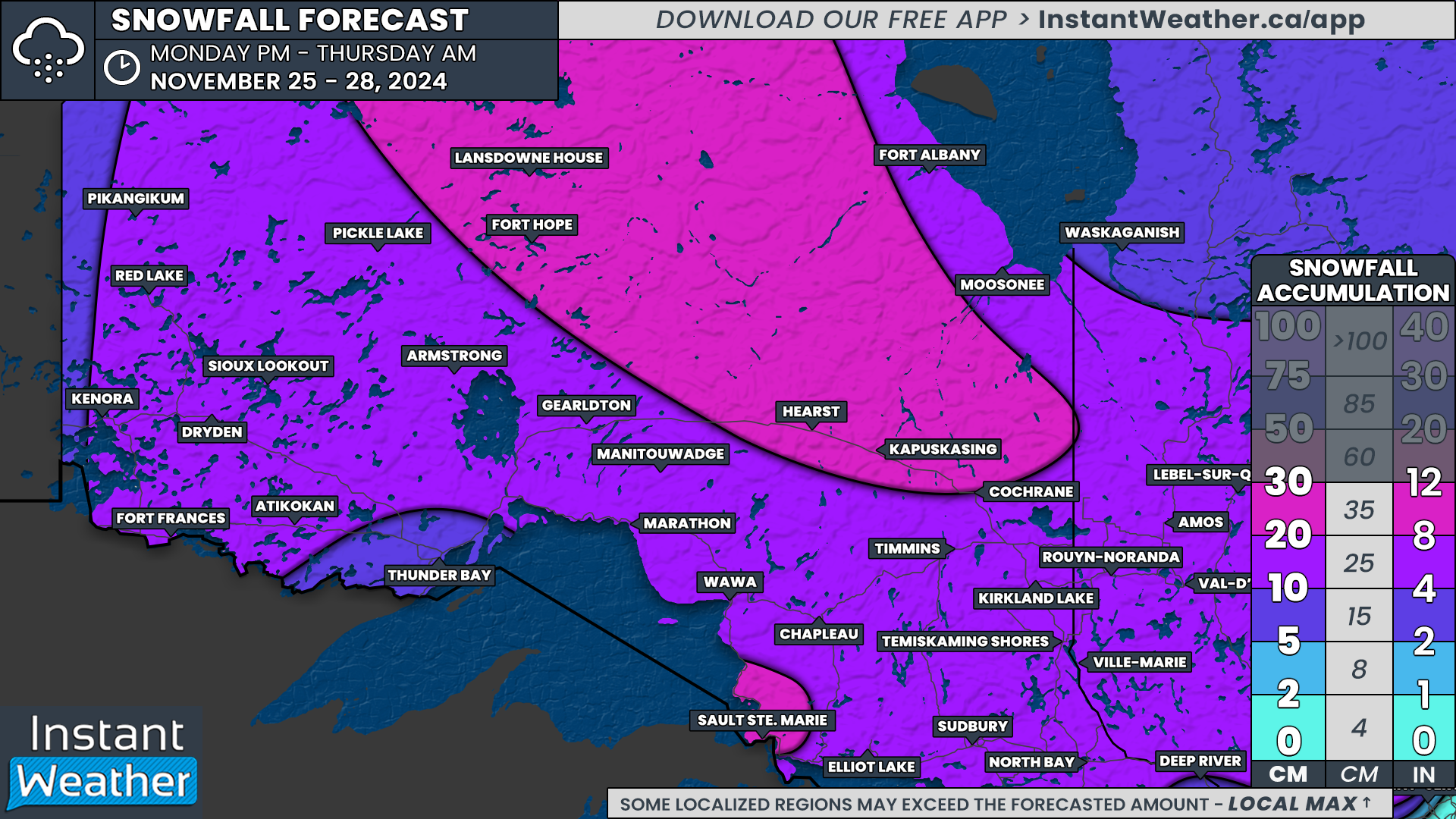
Northern Ontario will experience heavy snow from this same system, as colder air dominates in the region. Light to moderate snowfall is expected to begin in Northwestern Ontario by early Monday afternoon, gradually spreading eastward into the evening and overnight.

Snow will continue across Northern Ontario throughout Tuesday, with the heaviest snowfall expected near the Quebec border in Northeastern Ontario. Snowfall will gradually ease later on Tuesday and into early Wednesday but could persist near James Bay in a zone extending from Hearst to Lansdowne House.


GOOGLE AD (NOT ENDORSED BY INSTANT WEATHER)

Over three days, snowfall totals will generally range from 10 to 20 cm across Northern Ontario. Far Northern Ontario near James Bay could see totals exceeding 20 cm by Thursday, while lake-enhanced snowfall southeast of Lake Superior, including Sault Ste. Marie, could push totals closer to 30 cm.

Thunder Bay is expected to see slightly less snow, as the city may end up in a drier part of the system. Forecasts currently suggest snowfall amounts of 5 to 10 cm in this area.


GOOGLE AD (NOT ENDORSED BY INSTANT WEATHER)

Southern Ontario: Cold Air and Lake Effect Snow

PRECIPITATION TYPE - MAP FROM WEATHERBELL

As the system moves out of Southern Ontario late Tuesday, a surge of cold air will follow in its wake. This will briefly activate the lake effect snow machine around Lake Huron and Georgian Bay beginning Tuesday evening and lasting into Wednesday.


GOOGLE AD (NOT ENDORSED BY INSTANT WEATHER)

NOTE: YOU CAN CLICK ON THE MAP TO OPEN A ZOOMABLE IMAGE

At this time, temperatures are expected to hover near the freezing mark, which could limit significant accumulation. The most likely target zone for this initial burst of lake effect snow includes areas east of Georgian Bay, such as Parry Sound, Huntsville, and Bracebridge. These areas could see 10-15 cm, with localized amounts of up to 20 cm by the time snow bands taper off Wednesday evening.

For higher elevations southeast of Owen Sound, including Hanover, Markdale, Shelburne, and Orangeville, up to 5-10 cm of snow is possible, as cooler temperatures in these areas will allow snow to accumulate more easily. Surrounding regions, including parts of the Greater Toronto Area, may see just a few light flurries.


GOOGLE AD (NOT ENDORSED BY INSTANT WEATHER)

End of the Week: A Snow Squall Event Looms

NOTE: YOU CAN CLICK ON THE MAP TO OPEN A ZOOMABLE IMAGE

Lake effect snow will temporarily pause as another system slides through the Great Lakes region. However, this system appears to stay largely south of the border, bringing only a few flurries or light showers to areas near Lake Erie and the Golden Horseshoe early Thursday.

As we approach the weekend, Southern Ontario will see its coldest air of the season so far, with overnight lows plunging to several degrees below freezing across much of the province.


GOOGLE AD (NOT ENDORSED BY INSTANT WEATHER)

A dominant westerly to northwesterly wind is expected to develop Friday and persist into the weekend. This setup will create ideal conditions for intense snow squalls off Lake Huron, Lake Superior, and Georgian Bay starting Friday afternoon and lasting through the weekend.

These snow squalls could bring significant snowfall totals, blowing snow, and near-zero visibility to localized areas in the snowbelt. Travel could become difficult or even dangerous in the hardest-hit regions.

Based on the current forecasted wind direction, regions including Kincardine, Owen Sound, Hanover, Midland, Oro, Orillia, and Gravenhurst are likely to see the heaviest impacts. This also extends up into Northern Ontario around the Lake Superior shoreline with Sault Ste. Marie in the bullseye. Some locations within this zone could receive up to 50 cm of snow by the end of the weekend.


GOOGLE AD (NOT ENDORSED BY INSTANT WEATHER)

Snow Squall Uncertainty

It’s important to note that snow squalls are highly localized events, and not everyone will experience intense snowfall totals. One area may receive significant snow accumulations, while locations just a few kilometres away might see only a dusting.

Confidence is high that some sort of snow squall event will occur, but exact locations will depend on the finer details of wind direction and temperatures.

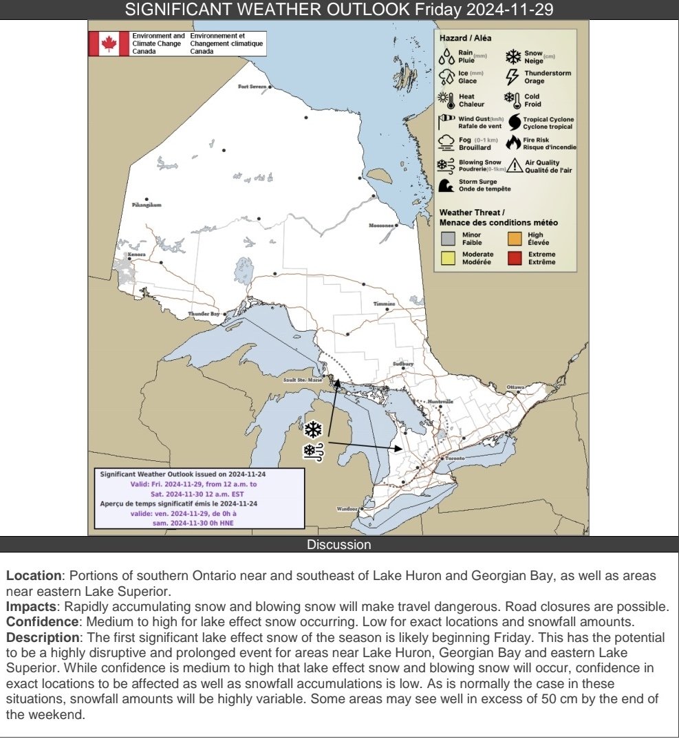
CREDIT: Environment CANADA

Environment Canada has also mentioned the potential for significant snow squalls later this week:

The first significant lake effect snow of the season is likely beginning Friday. This has the potential to be a highly disruptive and prolonged event for areas near Lake Huron, Georgian Bay and eastern Lake Superior. While confidence is medium to high that lake effect snow and blowing snow will occur, confidence in exact locations to be affected as well as snowfall accumulations is low. As is normally the case in these situations, snowfall amounts will be highly variable. Some areas may see well in excess of 50 cm by the end of the weekend. - Environment Canada

Stay tuned for updated forecasts in the coming days as higher-resolution models provide more details. We’ll refine the snow squall forecast and pinpoint areas most at risk.


Season’s First Snowfall Possible for Wide Swath of Southern Ontario Starting Late Wednesday

NOTE: YOU CAN CLICK ON THE MAP TO OPEN A ZOOMABLE IMAGE

Over the past week, calm conditions have dominated the weather story across Southern Ontario. This pattern has also brought a return to more seasonal temperatures typical for this time of year, a noticeable shift from the unseasonably warm weather that lingered into early November.


GOOGLE AD (NOT ENDORSED BY INSTANT WEATHER)

One notable absence so far this season is snow—a staple of November in Southern Ontario. While some regions, especially higher elevations in Central Ontario, the Ottawa Valley, and the Dundalk Highlands, experienced their first flurries as early as September and October, much of Southern Ontario has yet to see its first snowfall.

That, however, could soon change with the arrival of multiple weather systems in the coming days, bringing colder air and the potential for wet flurries as early as Wednesday evening and into Thursday and Friday.

The good news for those not yet ready to embrace winter is that significant accumulation isn’t expected with this initial blast of wintry weather. Temperatures are forecast to hover just above freezing, which will likely limit accumulation as any snow melts upon contact with the wet and relatively warm ground left behind by earlier rainfall.


GOOGLE AD (NOT ENDORSED BY INSTANT WEATHER)

In addition to the season’s first flurries, a slow-moving system will stall over the Great Lakes region, pulling in moisture from another system over New England. This setup will lead to ample precipitation, with heavy rain expected to persist into the start of the weekend. Eastern Ontario is poised to bear the brunt of this rainfall, with totals ranging from 25 to 50 mm between Wednesday and Saturday.

SIMULATED RADAR - MAP FROM WEATHERBELL

The rain is expected to begin on Wednesday afternoon, with the initial band of heavy rain arriving in Deep Southwestern Ontario and areas near the Lake Erie shoreline by dinnertime.

This line of precipitation may also bring embedded, non-severe thunderstorms and wind gusts of 70-80 km/h. While most gusts are expected to remain below the severe threshold, isolated gusts near 90 km/h are possible, particularly over the Niagara region during the early evening hours.


GOOGLE AD (NOT ENDORSED BY INSTANT WEATHER)

PRECIPITATION TYPE - MAP FROM WEATHERBELL

As this line of rain races across Southwestern Ontario and into the Golden Horseshoe, colder air will begin rushing in from the west. However, there is some disagreement among models regarding how quickly temperatures will drop and how rapidly the precipitation will move. Some projections suggest a sharp cooldown, with temperatures in Southwestern Ontario nearing freezing by Wednesday evening.

If this happens, rain could transition to wet snow in areas such as Sarnia, London, Goderich, Kitchener, Guelph, and Orangeville. However, with earlier rainfall and temperatures still above freezing, any snow is likely to melt on contact. Elevated areas northwest of the GTA, particularly the Dundalk Highlands, may see light accumulation of up to 2-4 cm overnight into Thursday morning.


GOOGLE AD (NOT ENDORSED BY INSTANT WEATHER)

PRECIPITATION TYPE - MAP FROM WEATHERBELL

By Thursday morning, most of the moisture will shift into Central and Eastern Ontario, with the centre of the low-pressure system stalled over Lake Huron. Meanwhile, a secondary system over New England will provide additional moisture, enhancing precipitation over Eastern Ontario throughout the day.

Temperatures in parts of Eastern Ontario, particularly southwest of Ottawa and in higher elevations, will hover near the freezing mark, creating a chance for wet flurries. Closer to the international border extending into the Ottawa region, heavy rain will likely continue.

Precipitation is expected to persist overnight Thursday and linger into Friday, with the heaviest rain focused on Eastern Ontario. In Central and Southwestern Ontario, lingering showers are possible Friday morning and afternoon, though they won’t be as intense as in the east.


GOOGLE AD (NOT ENDORSED BY INSTANT WEATHER)

NOTE: YOU CAN CLICK ON THE MAP TO OPEN A ZOOMABLE IMAGE

For rainfall totals, Eastern Ontario, including Kingston and Ottawa, can expect 25 to 50 mm by Saturday. The rest of Southern Ontario will likely see 10 to 25 mm, though isolated pockets could receive closer to 30-40 mm during thunderstorm activity.

Higher elevations in Eastern Ontario, particularly near Bancroft, may see persistent snow showers that could result in minor accumulation of up to 2-5 cm by Friday morning. However, with temperatures so close to freezing, it’s uncertain how much snow will stick.


GOOGLE AD (NOT ENDORSED BY INSTANT WEATHER)

Looking ahead to the weekend, there’s good news for those not ready for snow. Earlier model predictions suggested a significant cooldown that could trigger lake-effect snow. However, the latest data indicates the cooldown won’t be as intense as initially thought.

While some lake-effect showers are still possible along the Lake Huron shoreline and southeast of Georgian Bay on Saturday, it likely won’t be cold enough for those showers to fall as snow.

What's in a Name? Choosing the Right Tires to Drive you Through Canadian Winters

Tread patterns of summer, all season and winter tires. Image courtesy of discount tire.

Now that it’s the first week of November, many Canadians are starting to think about putting winter tires on their vehicles. There have been pockets of unseasonable warmth across the country in October and the start of November, the inevitable chill of winter is in the air, and many have already seen snow fall.

While winter tires are recommended throughout the country, they are mandatory in Quebec from December 1st to March 15th, and from October 1st to April 30th on certain British Columbia highways. Additionally, studded tires are allowed almost nationwide, with the exception of residents of Southern Ontario.

Insurance companies across the country offer discounts for installing winter tires as an incentive to encourage drivers to reduce the risk of accidents. So what makes winter tires that much better in the cold and snow than summer tires and where do all season and all weather tires fit into the mix?


GOOGLE AD (NOT ENDORSED BY INSTANT WEATHER)

With the right tools, it can be pretty easy to change your own tires!

Summer Tires

Summer tires are designed to handle both wet and dry road conditions with their wide tread and soft rubber. These tires also usually have deeper grooves that improve traction on wet roads and reduce hydroplaning, making them ideal for the wet spring and summer months.

Winter Tires

Like their name suggests, winter tires have been designed for winter roads. They are made with rubber that stays flexible at temperatures below 7°C (45°F), the magic number at which other tires become stiff and lose traction, greatly reducing their performance. Furthermore, winter tires have different tread patterns that are meant to divert water and slush to the sides, as well as little slits called sipes that increase the overall grip of the tires and helping them maintain contact with icy road surfaces. Over the past several years, tire manufacturers have started to include additional small particles, like crushed glass or walnut shells, that act as little studs on the surface of the tire for extra grip.


Performance of All Season Tires vs Winter Tires with decreasing temperatures. Image courtesy of Discount Tire.

All Season & All Weather Tires

Some people argue that winter tires aren’t necessary if they have all season tires on their vehicle. Unfortunately, this is a slight misnomer because while these tires can handle a bit of cold and snow, they fail to handle heavier snowfalls that are common in Canadian winters. All season tires, unfortunately, sacrifice traction in wet conditions that would be found in summer tires and some of the flexibility and grip seen with winter tires in order for the tread to last longer. Realistically, these should be called 3 season tires as opposed to all season. So while they’re not the best option for winter driving in Canada, all season tires are definitely a better choice than regular summer tires.

All weather tires, not to be confused with all season tires, are a true year-round tire designed to handle Canadian winters. Unlike all season tires, these tires remain soft and flexible well below 7°C. The tread pattern on all weather tires is a combination of all season and winter tires, making them better suited for driving through heavier snow than all season tires. While they still don’t match the performance of a true winter tire, all weather tires are the best option for those who don’t want the hassle of swapping out their tires twice per year or simply do not have the space to store an extra set. Their versatility truly makes all weather tires a middle of the road tire (pun intended) for Canadian drivers.


The three-peak mountain snowflake symbol found on winter and all weather tires. Image courtesy of Canadian tire.

When looking for tires to get you through the winter, it is recommended to chose either a proper winter tire or an all weather tire, so long as it has the three-peak mountain and snowflake symbol on the sidewall. This is an industry standard symbol which indicates that the tire meets strict regulations for winter performance; becoming mandatory on all winter tires beginning in 2018, transitioning away from just using the M+S (Mud and Snow) designation.


Further Reading

https://www.canadiantire.ca/en/how-to/automotive/how-to-choose-winter-tires.html

https://www.continental-tires.com/ca/en/tire-knowledge/winter-tire-laws-in-canada/

https://www.continental-tires.com/ca/en/tire-knowledge/winter-tire-markings/

https://www.discounttire.com/learn/tires-below-45

https://www.discounttire.com/learn/winter-summer-allseason

Note: The author formerly received payments from “Big Tire” however, this article was not funded.

Temperatures to Soar Above 20°C Across Southern Ontario on Tuesday With Gusty Winds

NOTE: YOU CAN CLICK ON THE MAP TO OPEN A ZOOMABLE IMAGE

As we step into the first days of November, the temperatures outside might have you double-checking the calendar, as the unusually warm trend of this fall continues. This lingering seasonal tug-of-war between cold and warm air has led to temperature swings from near-freezing to over 20°C in the past few weeks.


GOOGLE AD (NOT ENDORSED BY INSTANT WEATHER)

Despite the calendar saying November, it’ll feel more like early fall on Tuesday as temperatures rise to around 20°C across much of Southern Ontario. Accompanying this brief warm-up will be strong wind gusts, reaching 70-80 km/h in some areas.

A warm front moving across Southern Ontario is bringing in this surge of mild air, making its presence felt overnight into Tuesday. Already, spots around Lake Erie in southwestern Ontario are feeling this effect, with temperatures climbing near the 20°C mark by Monday evening.


In contrast, parts of Central Ontario and the Ottawa Valley have remained in the single digits, with areas near Ottawa hovering close to freezing. But don’t worry; that’s about to change as warmer air spreads in!

Overnight, temperatures will gradually rise, with most of Southern Ontario waking up to mild conditions in the mid to upper teens. In Central and Eastern Ontario, expect to start the day with temperatures in the lower teens.


GOOGLE AD (NOT ENDORSED BY INSTANT WEATHER)

Throughout Tuesday, the warm-up will continue, with daytime highs near 20°C or slightly higher in some areas. The latest data suggests the warmest air will be centred along the Golden Horseshoe and deep southwestern Ontario, including cities like Windsor and Chatham, where temperatures could reach 21-24°C. Some locations may even approach record highs, though with records around 23-25°C in many spots, breaking them might be a tall order.

The rest of Southern Ontario, except for the Bruce Peninsula and northern parts of Central Ontario, will enjoy temperatures around 18-21°C. Northern regions, including Tobermory, Parry Sound, Huntsville, and Algonquin Park, will see slightly cooler temperatures around 15-18°C. Meanwhile, Northeastern Ontario will experience mild conditions, with highs in the low to mid-teens.


GOOGLE AD (NOT ENDORSED BY INSTANT WEATHER)

TEMPERATURES 10-14°C ABOVE SEASONAL- MAP FROM WEATHERBELL

If 20°C temperatures in November seem strange, you're right! Daytime highs for this time of year are typically in the upper single digits or low teens, so we’re looking at temperatures around 10-14°C above average across Southern Ontario on Tuesday.


GOOGLE AD (NOT ENDORSED BY INSTANT WEATHER)

NOTE: YOU CAN CLICK ON THE MAP TO OPEN A ZOOMABLE IMAGE

Winds will also be a key feature on Tuesday, with gusts approaching 70 km/h across much of Southern Ontario by the morning. These winds should weaken somewhat later in the day but are expected to pick up again overnight into early Wednesday.


A few areas—particularly around Lake Erie, Niagara, higher elevations east of Lake Huron, and northeast of Georgian Bay—could see stronger gusts up to 80 km/h, although this will be highly localized. Most places should expect gusts around 70 km/h, with winds easing off by late Wednesday morning.


GOOGLE AD (NOT ENDORSED BY INSTANT WEATHER)

Northeastern Ontario will see heavy rain beginning early Tuesday morning and lasting through the day and night, with rainfall totals reaching 30-50 mm by Wednesday afternoon in some spots.

Southwestern Ontario will also see moderate to heavy rain starting early Wednesday morning, which will then spread eastward to the Golden Horseshoe and Eastern Ontario by late morning. However, some models indicate that the rain might weaken before reaching Eastern Ontario, resulting in only a few millimeters. Southwestern and Central Ontario could see rainfall amounts of 5-15 mm.


GOOGLE AD (NOT ENDORSED BY INSTANT WEATHER)

Wednesday will bring a dramatic change as a cold front sweeps across Southern Ontario, leading to a significant temperature drop by the day’s end. By Wednesday evening, temperatures across much of Southern Ontario will fall sharply into the low to mid-single digits, giving us a reminder that winter is just around the corner.

Spooky Skies Ahead! Southern Ontario Could See Warmest Halloween on Record; Up to 10-15cm of Snow Could Haunt Northern Ontario

NOTE: YOU CAN CLICK ON THE MAP TO OPEN A ZOOMABLE IMAGE

Excitement is brewing as Halloween night approaches, and the streets are set to fill with little ghosts, goblins, and creatures of the night. However, it seems Mother Nature may have skipped the “or” in Trick-or-Treat this year. While Southern Ontario is in for an unusually warm treat, there’s also a wintry “trick” in the forecast, as the first messy winter system of the season stirs up across the northern portion of the province.


GOOGLE AD (NOT ENDORSED BY INSTANT WEATHER)

Before we dive into the chilly details, let’s savor the treat: a Halloween night warmer than most! Unlike Halloweens past, where bone-chilling temperatures hovered near or below freezing, this year brings weather that feels more like late summer or early fall. Temperatures across Southern Ontario will keep that warm spell lingering, with some areas possibly experiencing record-breaking highs for Halloween.

In years past, Canadian trick-or-treaters have bundled up with extra layers under their costumes to ward off the cold. This Halloween, they may find themselves shedding layers, with temperatures expected to reach the upper teens and even low 20s in some spots.

Prime trick-or-treating time around 8 PM will bring readings of 16-20°C across much of Southern Ontario, with slightly cooler temperatures between 14-16°C around Algonquin Park and the Bruce Peninsula. Daytime highs earlier in the day may reach the low or even mid-20s, with some areas potentially setting new temperature records.

However, Halloween night won’t stay warm for long. A cold front will sweep through late in the evening, quickly dropping temperatures as it ushers in much colder air overnight. Those celebrating late into the witching hour should brace themselves for temperatures plunging into the single digits by early Friday morning.


GOOGLE AD (NOT ENDORSED BY INSTANT WEATHER)

Northern Ontario’s Ghostly Chill

NOTE: YOU CAN CLICK ON THE MAP TO OPEN A ZOOMABLE IMAGE

While Southern Ontario basks in warmer weather, the tale turns a bit chillier in Northern Ontario. Southern portions of Northeastern Ontario, including Elliot Lake, Sudbury, and North Bay, will enjoy temperatures between 12-16°C during Halloween evening. But for Central Northeastern communities like Chapleau, Temiskaming Shores, and Kirkland Lake, temperatures will drop to single digits, adding an extra shiver to the festivities.


Northwestern and Far Northern Ontario will already be feeling the effects of the cold front by trick-or-treat time, with temperatures hovering near or just below the freezing mark. In these areas, those venturing out for Halloween night will definitely need to incorporate extra layers into their costumes.


GOOGLE AD (NOT ENDORSED BY INSTANT WEATHER)

So, Where’s the Trick?

PRECIPITATION TYPE FOR Halloween EVENING - MAP FROM WEATHERBELL

You may be wondering, with all this warm weather, where’s the trick in this Halloween forecast? The trick this year will be what’s coming down from the sky. Scattered rain showers are set to creep into Southern Ontario starting Thursday afternoon, with the heaviest rainfall likely in parts of Northeastern Ontario and along the western areas of Southern Ontario.

In fact, there could even be isolated thunderstorms around Georgian Bay. So if you’re out collecting candy, keep an eye on the skies, and take cover if you see lightning or hear thunder. Trick-or-treaters in Eastern Ontario, on the other hand, might just escape the rain until later in the evening.


GOOGLE AD (NOT ENDORSED BY INSTANT WEATHER)

Fortunately, rainfall amounts across Southern Ontario are expected to stay light, with 5-15 mm in areas seeing the heaviest showers. Thunderstorm activity could increase these totals in very localized spots, but nothing overly dramatic.

The heaviest rain will be concentrated in Northeastern Ontario, stretching from Sault Ste. Marie through Sudbury and up to North Bay. Some of these areas are currently under a rainfall warning from Environment Canada, with up to 60 mm of rain possible from Wednesday night through Friday morning.


GOOGLE AD (NOT ENDORSED BY INSTANT WEATHER)

A Halloween Surprise: Snow in Northern Ontario!

NOTE: YOU CAN CLICK ON THE MAP TO OPEN A ZOOMABLE IMAGE

And now, for the big Halloween scare! As rain moves across Ontario, colder air in the north will bring a chilling twist, transforming rain into snow by Thursday afternoon in some areas. The spooky snowfall is set to begin from Wawa up through Kapuskasing, with heavy snow expected to continue through the overnight hours into Friday morning.

For those areas in the “snow zone,” accumulation could be significant. A corridor stretching from Wawa to Kapuskasing may see up to 10-15 cm of snow by Friday morning, though actual amounts may vary based on temperatures near the freezing mark, which can affect how well snow sticks to the ground.


Surrounding areas, including Wawa, Kapuskasing, Timmins, and Cochrane, could see 5-10 cm of snow accumulation. However, warmer ground temperatures may mean that some snow melts on contact, reducing the totals.

Northeastern Ontario, north of a line from Sault Ste. Marie to Sudbury, may also pick up a dusting to a few centimetres of snow Thursday night into Friday, with up to 5 cm possible. Thunder Bay could even see a few flurries, though no accumulation is expected there.

So, Ontario, prepare for a Halloween that’s part treat, with warm weather for many, and part trick, with rain and snow making an appearance in others. However, you plan to celebrate, have a safe and spooky Halloween night!

Spooky Snow May Make an Appearance in Parts of Ontario to Kick Off Halloween Week

NOTE: YOU CAN CLICK ON THE MAP TO OPEN A ZOOMABLE IMAGE

The month of October has mostly brought calm and mild conditions to Ontario, with temperatures occasionally climbing above seasonal averages and minimal precipitation. But as we approach the final days leading up to Halloween, colder air is making a return, setting the stage for a possible wintry “trick” in parts of the region.


GOOGLE AD (NOT ENDORSED BY INSTANT WEATHER)

This past week, temperatures in some areas reached the upper teens and even low 20s, but now a noticeable chill has settled in. Many spots across Southern and Northern Ontario are already experiencing single-digit highs as the warm air retreats.

As the weekend progresses, the cold will only deepen, with Sunday morning expected to bring temperatures near or just below freezing across the province. Afternoon highs will provide little relief, as most places in Central and Eastern Ontario will likely struggle to rise out of the single digits.


GOOGLE AD (NOT ENDORSED BY INSTANT WEATHER)

A Weak Weather System and a Chance of Snow

PRECIPITATION TYPE FOR SUNDAY EVENING - MAP FROM WEATHERBELL

On Sunday, a weak weather system will begin to make its way into Northeastern Ontario and eventually move toward Central Ontario by the afternoon. This will likely bring some light rain showers to areas like Sault Ste. Marie, Sudbury, North Bay, and Muskoka. As colder air continues to push southward after sunset, temperatures will drop quickly, setting the stage for a possible transition from rain to wet snow in the evening.


While surface temperatures are expected to stay just above freezing until after midnight, colder air moving in aloft may allow the rain to change to snow as the night progresses. Precipitation will gradually spread southeastward, reaching Bancroft, Kingston, and possibly the Ottawa area.

There is some uncertainty about whether Ottawa itself will see any snowflakes, as models suggest that a dry air pocket may limit snowfall, keeping the bulk of moisture just to the south.


GOOGLE AD (NOT ENDORSED BY INSTANT WEATHER)

Potential for Accumulation and a Hard Freeze

ESTIMATED MINIMUM TEMPERATURE ON MONDAY MORNING - MAP FROM WEATHERBELL

Temperatures will continue to drop overnight, leading to what is referred to as a “hard freeze” in areas like Sudbury, North Bay, Algonquin Park, and the Ottawa Valley. During a hard freeze, temperatures remain several degrees below freezing for extended periods, which could kill sensitive plants.

The drop in temperature may also allow for some light snow accumulation, with a dusting of 2-3 cm possible by Monday morning in some areas. Though not a significant amount, it could be enough to create slippery conditions on roads, making for a potentially slow and hazardous Monday morning commute.


Light flurries may linger across parts of Central and Eastern Ontario into late Monday morning, gradually tapering off around noon. With temperatures hovering close to the freezing mark throughout the day, any snow that does manage to accumulate will likely melt slowly. Motorists should remain cautious, as wet or slushy conditions could persist longer than usual.


GOOGLE AD (NOT ENDORSED BY INSTANT WEATHER)

Midweek Warm-Up on the Horizon

ESTIMATED DAYTIME HIGH TEMPERATURE ON WEDNESDAY - MAP FROM WEATHERBELL

For those hoping for a break from the cold, a warm-up is expected by midweek. By Tuesday, daytime highs in parts of Southwestern Ontario could rebound into the low to mid-20s, with the warmer air spreading to Central and Eastern Ontario by Wednesday.

However, the return of milder weather may be accompanied by some wet conditions. A fast-moving weather system is forecast to pass through Southern Ontario on Tuesday, bringing the potential for 15-30 mm of rainfall across Central and Eastern Ontario between late Tuesday and Wednesday.

While the exact track remains uncertain, some models suggest the rain may shift further north, potentially impacting the area differently than initially expected.


GOOGLE AD (NOT ENDORSED BY INSTANT WEATHER)

What’s in Store for Halloween?

ESTIMATED TEMPERATURE FOR HALLOWEEN AT 8 PM - MAP FROM WEATHERBELL


With Halloween fast approaching, many Ontarians are wondering what the weather will be like for Trick-or-Treating. As of now, forecasts indicate a chance of widespread rain across much of Southern Ontario during the afternoon, possibly lingering into the evening. Afternoon temperatures are expected to start in the mid to upper teens, but a cooling trend may bring them down to the low teens or even upper single digits by the time Trick-or-Treaters hit the streets.

There is still some disagreement among models regarding the exact timing of the rain. While it seems the heaviest precipitation may fall earlier in the day, there is a chance that skies could clear in time for the evening festivities, especially in Southwestern Ontario. Meanwhile, Eastern Ontario may be among the last regions to see any potential clearing.

Stay tuned as more details emerge in the days leading up to Halloween, and be prepared for whatever weather “tricks” or “treats” may come your way!

Trick-or-Treat: A Potential Spooky ‘Headless’ Comet Could Be Visible Across Canada Around Halloween

It's been a spectacular year for skywatchers across Canada, with events like solar eclipses, supermoons, and vibrant northern lights lighting up the night. Now, it looks like we might be in for another treat—a "headless" comet could make an appearance just in time for Halloween.


GOOGLE AD (NOT ENDORSED BY INSTANT WEATHER)

October seems to be the month of comets, with Comet Tsuchinshan-ATLAS gracing the early evening skies recently. Many stargazers caught glimpses of the comet, which was visible in the western sky just after sunset. Although it has since faded from naked-eye visibility, you can still catch it with a telescope, and it will remain somewhat visible into early November.

But the cosmic show isn’t over yet. A second comet, called Comet ATLAS (C/2024 S1), may arrive just in time for Halloween, and it comes with a spooky twist—it could appear "headless." The comet’s name might sound familiar because it was discovered by the same ATLAS asteroid tracking system, known for spotting objects that could potentially impact Earth.


GOOGLE AD (NOT ENDORSED BY INSTANT WEATHER)

The main difference between this upcoming comet and the earlier one lies in its path. While the first comet passed safely between Earth and the Sun, around 40 million miles from the Sun, this new comet will come much closer, potentially within 700,000 miles of the Sun's surface. Because of this close approach, scientists predict that the comet’s head—its bright core—might disintegrate due to the Sun's intense heat, leaving just a faint, trailing tail visible from Earth.

To understand what makes a comet appear "headless," it's important to know a bit about its structure. Comets are made up of a nucleus, or core, composed of rock, dust, and frozen gases. When they approach the Sun, the heat causes the frozen gases to vaporize, forming a glowing coma around the nucleus and a tail that extends away from the Sun. If the nucleus disintegrates, the glowing head might vanish, leaving behind only a ghostly tail, hence the term "headless comet."


GOOGLE AD (NOT ENDORSED BY INSTANT WEATHER)

ESTIMATED BRIGHTNESS OF COMET - SOURCE: sKYWALK.SPACE

The exact visibility of this comet remains uncertain. It will come closest to Earth on October 24th as it travels toward the Sun, reaching its closest point to the Sun, known as perihelion, on October 28th. There’s even a chance it could be bright enough to see during the day, potentially appearing as bright as Venus from 7:12 AM to 8:06 AM (ET) in the east-southeastern sky.

However, those in the Northern Hemisphere may struggle to spot it due to its position low in the sky near the Sun, making it difficult to see without obstruction from sunlight or clouds.


GOOGLE AD (NOT ENDORSED BY INSTANT WEATHER)

NASA offers some tips for spotting the comet during this close approach. To view it safely, you should block the Sun with an object such as a building or tree, then scan the lower left of the Sun's position in the sky. Be cautious and never use binoculars or telescopes, as accidentally focusing on the Sun can cause serious eye damage.

If the comet survives its close encounter with the Sun, it could become visible in the night sky around Halloween. This would provide skywatchers with a unique opportunity to see a potentially "headless" comet, with a long, wispy tail but no visible nucleus. The darkness of the moonless night sky could offer ideal conditions for observing this unusual celestial visitor, making it a fitting cosmic event for the spooky season.


GOOGLE AD (NOT ENDORSED BY INSTANT WEATHER)

There is always the possibility that the comet disintegrates completely, leaving nothing visible to the naked eye. But if it endures, it will gradually fade after November 1st, requiring binoculars or a telescope for further observation. Unlike earlier this month, when a supermoon washed out the sky, the absence of a full moon could make for an even more impressive show, assuming the comet survives.

Stay tuned for updates as we keep an eye on this intriguing comet.

Why the Northern Lights Are Appearing More Frequently: NASA and NOAA Confirm Solar Maximum

Visible light images from NASA’s Solar Dynamics Observatory highlight the appearance of the Sun at solar minimum (left, Dec. 2019) versus solar maximum (right, August 2024). During solar minimum, the Sun is often spotless. Sunspots are associated with solar activity, and are used to track solar cycle progress. Credit: NASA/SDO

During a recent teleconference, experts from NASA, NOAA, and the International Solar Cycle Prediction Panel confirmed that the Sun has entered its solar maximum, a period of heightened solar activity expected to last through the next year.

The solar cycle reaches this peak roughly every 11 years, during which the Sun shifts from a relatively calm state to a much more active phase characterized by increased magnetic activity and a higher number of sunspots. These sunspots, which are cooler areas on the Sun’s surface caused by intense magnetic fields, can trigger powerful solar eruptions that significantly impact space weather.

This surge in solar activity doesn’t just make for an interesting spectacle; it can also have practical consequences on Earth. Solar flares and eruptions during this time can interfere with communications, disrupt GPS signals, and even affect power grids. They can also pose potential hazards to satellites and astronauts in orbit.

But for skywatchers, there is an upside: the solar maximum period also brings more frequent and spectacular aurora displays. The increased solar storms energize the Earth’s magnetosphere, producing stunning Northern Lights that light up the night sky.


GOOGLE AD (NOT ENDORSED BY INSTANT WEATHER)

The Solar Cycle 25 forecast, produced by the Solar Cycle 25 Prediction Panel, which is co-chaired by NASA and NOAA. Sunspot number is an indicator of solar cycle strength - the higher the sunspot number, the stronger the cycle. Credit: NOAA’s Space Weather Prediction Center

This past May, a powerful series of solar flares and coronal mass ejections (CMEs) resulted in one of the most intense geomagnetic storms seen in decades, setting the stage for breathtaking aurora displays visible across Canada. For many, it was a rare opportunity to experience the vivid greens, reds, and purples dancing across the sky.

If you didn’t catch those May displays or other recent aurora events, there’s no need to worry. With the Sun currently in its solar maximum, NASA and NOAA anticipate ongoing solar and geomagnetic storms in the coming months, which means there will be many more chances to witness the auroras.

Although the Sun is already in an active phase, pinpointing the exact peak of this cycle will take time as scientists closely monitor the number and intensity of sunspots and solar eruptions.


GOOGLE AD (NOT ENDORSED BY INSTANT WEATHER)

Exciting research efforts are also underway to better understand the Sun's behavior during this dynamic period. NASA is preparing for a major milestone in solar exploration, with the Parker Solar Probe set to make its closest approach to the Sun in December 2024. This mission, along with other initiatives, aims to deepen our knowledge of space weather and its effects on our planet.

Here at Instant Weather, we’re committed to keeping you informed about significant solar activity and providing timely alerts for aurora viewing opportunities across Canada. As the Sun continues to show off during this solar maximum, be sure to stay tuned for updates and get ready for more spectacular light shows in the sky.


After a Slow Start, Fall Colours Now Entering Peak Across Southern Ontario

NOTE: YOU CAN CLICK ON THE MAP TO OPEN A ZOOMABLE IMAGE

An unusually warm start to autumn across Southern Ontario has delayed the typical fall colour transformation, leaving many waiting longer than usual for those vibrant displays. In our last update from early October, peak colours had only been reached in Central Ontario and parts of Eastern Ontario, several weeks later than usual.

However, the colder weather that settled in over the past few weeks has helped speed up the transformation across the region. As we head into the weekend, most areas in Southern Ontario are now approaching or experiencing peak colour change.


GOOGLE AD (NOT ENDORSED BY INSTANT WEATHER)

For provincial parks that reached their peak earlier this month—such as Algonquin Park, Arrowhead, and Bonnechere—the best days have likely passed, with reports indicating that fewer than 40% of the leaves remain on the trees.

Note: The above map is extrapolated using data from OntarioParks.ca, but some parks may not have updated their latest report yet. As such, the actual colour change in your area may be further along than currently reported.

Keep in mind that many parks have closed for the season after Thanksgiving, which explains why some areas lack data in our latest updated map.

Currently, the following parks are experiencing peak fall colours:

  • Arrowhead: 100% colour change | 40% leaf fall

  • Balsam Lake: 60% colour change | 30% leaf fall

  • Batchawana Bay: 90% colour change | 40% leaf fall

  • Bon Echo: 80% colour change | 50% leaf fall

  • Bronte Creek: 50% colour change | 20% leaf fall

  • French River: 80% colour change | 50% leaf fall

  • Killarney: 80% colour change | 40% leaf fall

  • Killbear: 60% colour change | 30% leaf fall

  • MacGregor Point: 60% colour change | 40% leaf fall

  • Mark S. Burnham: 50% colour change | 40% leaf fall

  • Mono Cliffs: 60% colour change | 20% leaf fall

  • Oxtongue River-Ragged Falls: 100% colour change | 40% leaf fall

  • Sauble Falls: 100% colour change | 40% leaf fall

  • The Massasauga: 90% colour change | 20% leaf fall


The last regions still waiting to reach peak colours are in Deep Southwestern Ontario, along the Lake Erie shoreline, and in parts of the Golden Horseshoe. Parks in these areas, including Pinery, Wheatley, Rondeau, Turkey Point, Darlington, Presqu'ile, and Sandbanks, are reporting between 30-40% colour change. It's likely that these parks will reach peak colours by next weekend.

Remember that peak fall colours typically last for about a week or two, but this can vary based on weather conditions. The peak period ends once more than 50% of the leaves have fallen, which can happen quickly after a strong windstorm. So, make the most of the season and get out there while the colours are at their brightest!

Toronto’s Storm of the Century: Remembering Hurricane Hazel 70 Years Later

Overhead view of Raymore drive in Toronto following hurricane hazel, courtesy of Toronto and Region Conservation Authority.

It was on this day 70 years ago, in 1954, that the now infamous Hurricane Hazel hit Southern Ontario and caused catastrophic damage to Toronto. It is considered the area’s worst natural disaster and has shaped development for years to come. The storm produced winds up to 124km/h and dumped over 200mm of rain in just 24 hours; left 81 people dead and over 4000 families homeless, 1868 of those families in Toronto; and caused over $135 million in damages in Ontario ($1.5 billion by today’s standards). Hazel changed the way conservation authorities operate across Ontario and those impacts are still felt to this day.


GOOGLE AD (NOT ENDORSED BY INSTANT WEATHER)

Hurricane Hazel's Path, October 14-15, 1954, Courtesy of the National Weather Service.

Hurricane Hazel was first identified on October 5, 1954 by a Hurricane Hunters aircraft from Puerto Rico which located it just east of the island nation of Grenada in the West Indies. The plane estimated that the storm was already a Category 2 hurricane with winds estimated at 160km/h, but this value was more recently revised to 105km/h, making Hazel a Tropical Storm at the time, during reanalysis of former hurricane seasons by NOAA. Hazel intensified following the Hurricane Hunters mission and it made its first landfall over Grenada on the evening of the 5th as a Category 1 hurricane with winds estimated at 120km/h.

From there, Hazel tracked west-northwestward off the northern coast of Venezuela for the next few days, gaining strength along the way. Late on October 9th, Hazel gained Major Hurricane status with winds estimated at 195km/h. The next day, the storm made a sharp turn and started churning northeastward, where it eventually made two separate landfalls on Haiti’s west coast, initially over the Tiberon Peninsula as a Category 3 with winds estimated at 195km/h in the pre-dawn hours on the 12th and then as a Category 2 with estimated winds of 160km/h later that same evening over the northern peninsula. Hurricane Hazel killed up to 1000 people in Haiti and devastated the economy, destroying 40% of the nation’s coffee trees and 50% of the cacao crop.

Following its second landfall in Haiti, Hurricane Hazel curled northwestward and made its fourth total landfall in Inagua, an island in the Bahamas, less than 18 hours later on the morning of the 13th. The storm maintained its Category 2 strength between the two landfall occurrences, hitting the Bahamas with winds estimated at 160km/h.

Beyond the Bahamas, Hazel gained speed and reintensified, becoming a Category 4 hurricane on the evening of October 14th. Just before noon on October 15th, Hazel made its fifth and final landfall near the border of North Carolina and South Carolina as a Category 4 hurricane with sustained winds of 215km/h and gusts up to 240km/h. Hazel quickly transitioned to a post-tropical cyclone, but it maintained hurricane-force winds as it quickly pushed through D.C., Pennsylvania, New York, and towards the Canadian border. The storm killed 95 Americans and caused over $1.5 billion of damage by today’s standards.


GOOGLE AD (NOT ENDORSED BY INSTANT WEATHER)

Surface Chart from 8:3pm ET showing the location of Hazel over Southern Ontario, Courtesy of the National Weather Service.

As Hazel made its way northward through the States, Canadian authorities began issuing warnings to the general public, but most people didn’t know how to prepare for a hurricane. The storm began to weaken over the Allegheny Mountains in West Virginia and meteorologists expected it to dissipate, however the opposite happened. Instead, Hazel encountered a low-pressure system over western New York and intensified just before it crossed into the Niagara Peninsula.

Hurricane Hazel was a post-tropical Category 1 storm that brought severe wind gusts of up to 124km/h to a large portion of Southern Ontario on October 15th, but the winds were not the main concern from the storm. By the evening rush hour, the winds began to die down, but according to Chief Meteorologist Brian Turnbull, the worst of the storm was yet to come. The days leading up to Hazel’s arrival were quite wet so when the heavy rainfall began in the late afternoon, it didn’t take long for flooding to begin. Significant deforestation and development on the saturated flood plains across Toronto could not contain the over 200mm of rain that fell in 24 hours which resulted in many rivers overtopping their banks, with water levels rising by up to 8 metres. The Humber River, in particular, became a deadly torrent through the city, washing away roads, bridges, and entire homes. Overall, the storm dumped 181.6 billion litres of rain on the City of Toronto.

In total, 81 people lost their lives from Hurricane Hazel, mostly in the west end of Toronto. Across Southern Ontario, approximately 4000 families lost their homes, 1868 of which were in Toronto. Raymore Drive was hit particularly hard with 14 homes being washed away, killing 35 people. Fortunately, the death toll could have been much worse if not for the heroics displayed by many police officers, firefighters, and ordinary citizens who worked tirelessly trying to save those who became stranded. Sadly, five firefighters lost their lives when trying to rescue trapped motorists.

The effects of Hurricane Hazel were felt beyond Toronto. Significant flooding was experienced in communities as far west as London and north to Georgian Bay as the storm progressed northwards to James Bay, where it eventually dissipated.

Members of the Harbour Patrol Rescue a man from the Don River, courtesy of the Canadian Encyclopedia.


GOOGLE AD (NOT ENDORSED BY INSTANT WEATHER)

In the aftermath of Hurricane Hazel, many changes were made to conservation authorities across Ontario, especially in the Greater Toronto Area.

An intensive plan was put in place by conservation authorities, along with both the municipal and provincial governments, for flood control and water conservation in order to limit loss of life and property from future extreme weather events. As part of this plan, flood control facilities were inspected, upgraded, or built alongside additional dams and reservoirs to control and monitor water levels. A flood forecasting and warning system was also a large component to the plan.

An amendment was made to the Conservation Authorities Act that allowed individual conservation authorities to obtain and control vulnerable areas to be used for conservation and recreation. As a result, many homes were cleared from low-lying areas and greenbelts were created within watersheds. This included the expropriation of most remaining properties on Raymore Drive by the Metro Toronto and Region Conservation Authority which was turned into parkland, now called Raymore Park.

As we look back on the anniversary of this tragic event, we want to remember those that were lost and all of the efforts that have been put in place since to prepare for future extreme weather events. The City of Toronto has seen many flooding events since Hurricane Hazel, and it will continue to do so for many year. However, major floods in 2013 and more recently in 2024 show that more work still needs to be done.

The G. Ross Lord Dam, One of the Many Flood Control Measures in Place Across Toronto, Courtesy of the Toronto and Region Conservation Authority.


Sources:

https://www.aoml.noaa.gov/hrd/hurdat/hurdat2.html

https://www.heritage-matters.ca/articles/hurricane-hazel-50-years-later

https://www.heritagetrust.on.ca/pages/programs/provincial-plaque-program/provincial-plaque-background-papers/hurricane-hazel

https://www.hurricanehazel.ca/ssi/evolution_flood_control.shtml

https://www.thecanadianencyclopedia.ca/en/article/toronto-feature-hurricane-hazel

https://www.thecanadianencyclopedia.ca/en/article/hurricane-hazel

https://www.trca.ca/news/hurricane-hazel-70-years/

https://www.weather.gov/mhx/Oct151954EventReview

Post-Thanksgiving Cool Down to Bring Season’s First Flurries to Parts of Southern Ontario on Tuesday

NOTE: YOU CAN CLICK ON THE MAP TO OPEN A ZOOMABLE IMAGE

The chill is definitely in the air following the Thanksgiving long weekend across Ontario, with overnight lows hovering around the freezing mark in many areas over the past few days.

This is a sharp change from the mild autumn weather we experienced throughout September, which has led to a noticeable delay in the changing of the leaves. While the trees are still taking their time to show off their fall colors, other signs of the season are on the way over the next few days.

Most notably, the combination of colder air and the warm waters of the Great Lakes will create ideal conditions for lake-effect precipitation to develop off Lake Huron and Georgian Bay.

While most areas will see lake-effect rain, it could get cold enough along the higher elevations of the Dundalk Highlands, south of Georgian Bay, for some wet flurries to appear on Tuesday.


GOOGLE AD (NOT ENDORSED BY INSTANT WEATHER)

Additional precipitation is expected to move into Northeastern and Central Ontario by late Tuesday. As temperatures approach the freezing mark, some areas may see a transition to wet snow. However, significant accumulation is not expected, as the snow will likely melt almost immediately due to the warm ground, which remains above freezing.

For those who miss the milder weather, there’s no need to worry—there’s a warm-up on the way as we head into the weekend and early next week. Some areas could see daytime highs reaching the upper teens or even low twenties, which is well above the seasonal average for this time of year.


PRECIPITATION TYPE DURING THE DAY ON TUESDAY - MAP FROM WEATHERBELL

On Tuesday morning, most places will wake up to temperatures near the freezing mark, but daytime highs are expected to gradually rise into the mid to upper single digits. The higher elevations around Orangeville and Shelburne may struggle to climb above freezing, holding onto near-freezing temperatures throughout the day.

Lake-effect rain is expected to continue south of Georgian Bay throughout Tuesday, and some wet snow could mix in over the Dundalk Highlands during the day. This potential for flurries will be highly localized to the higher elevations between Owen Sound and Orangeville, while areas outside this region are likely to avoid the season’s first snowfall for now.

With temperatures hovering near or just above the freezing mark, significant accumulation is unlikely, as most of the snow will melt upon contact with the ground. However, there is a chance of a few wet, slushy centimeters in very localized areas.


GOOGLE AD (NOT ENDORSED BY INSTANT WEATHER)

PRECIPITATION TYPE DURING TUESDAY night - MAP FROM WEATHERBELL

As we move into the evening and overnight hours, temperatures will again drop to near the freezing mark across Central, Eastern, and Northeastern Ontario. With scattered showers arriving from the north and east, there is a possibility that some of this precipitation could fall as wet flurries overnight and into early Wednesday morning.

Accumulation will remain a challenge due to the relatively warm ground. However, those in Huntsville, Algonquin Park, and the Ottawa Valley might catch a glimpse of their first snowflakes of the season. The chance of snow will diminish by late Wednesday morning as lake-effect precipitation weakens and any lingering showers move out of the region.

As mentioned earlier, we’re expecting a gradual warm-up for the rest of the week, though the mornings will still start off chilly, with temperatures in the single digits. The real warming trend will kick off on Friday, with temperatures climbing into the upper teens and possibly even approaching the low twenties in Southwestern Ontario and around the Golden Horseshoe.

This milder weather is expected to continue through the weekend and into early next week.

Ontario’s Potential Last Severe Thunderstorm Risk of the Year on Sunday to Usher In a Chilly Start This Week

NOTE: YOU CAN CLICK ON THE MAP TO OPEN A ZOOMABLE IMAGE

Get ready, Ontario! While we've been enjoying a relatively mild start to fall, aside from a few exceptions, a significant change is on the horizon. As we head into the first weekend of October, it looks like Mother Nature is gearing up to bring in more seasonally appropriate weather. But, true to Ontario's reputation, it won’t happen quietly.

The weekend so far has seen relatively calm weather across Southern Ontario, with many areas enjoying pleasant temperatures in the mid to upper teens. This marks a shift from the consistent 20°C-plus days we experienced through much of September. While it's been nice, things are about to take a turn. We’re expecting a sudden surge of warmer air on Sunday, and that warm-up could set the stage for some potentially severe weather as we move into the morning and afternoon hours.


GOOGLE AD (NOT ENDORSED BY INSTANT WEATHER)

This brief October "heatwave" could push temperatures close to 20-25°C in Deep Southwestern Ontario and across the Golden Horseshoe. For those of you in Central and Eastern Ontario, however, don’t expect to feel much of this warmth. A stubborn pocket of cooler air is going to dig in, holding temperatures in the mid-teens across that region, keeping it much cooler than the rest of the province.

Unfortunately, this warm-up isn’t all sunshine. It will come hand-in-hand with some unsettled weather. A potentially strong line of thunderstorms is expected to cut across Southern Ontario on Sunday morning and afternoon. The latest data suggests that this line of storms could develop over Lake Huron by late morning and track eastward, making its way onshore just east of Lake Huron and Georgian Bay.


SIMULATED RADAR @ 12 PM ON SUNDAY - MAP FROM WEATHERBELL

There is still some uncertainty regarding the intensity of these storms. The early timing and limited warm air this far north may impact how severe the storms get. However, the atmosphere seems primed to support at least a marginal severe threat. We could see strong wind gusts, potentially reaching 90 km/h, and even hail up to quarter-size. There’s also a possibility that the risk level could be upgraded to slight by morning if conditions appear more favourable.

There is a low tornado risk—while it can’t be completely ruled out, the messy, linear storm structure might limit the chances of an isolated tornado forming. Still, it’s always better to stay cautious when severe weather is in the forecast.


GOOGLE AD (NOT ENDORSED BY INSTANT WEATHER)

This line of storms will continue pushing eastward through the Golden Horseshoe and areas east of Lake Simcoe by early to mid-afternoon. There’s potential for some intensification as the day progresses, or we could even see additional storms developing in the wake of the initial line. The zone between Bancroft, Peterborough, and Durham Region, and possibly stretching into Niagara, seems to have the highest risk for severe weather, should the conditions align more favourably.

By the late afternoon, the bulk of the storm activity will shift into the United States, where further severe weather could develop over Upstate New York and Pennsylvania. As a result, the storm threat across Southern Ontario should rapidly diminish by early evening. Given the time of year and the fact that cooler weather is set to follow, it’s quite possible that this could be our last widespread severe weather event of the season.


GOOGLE AD (NOT ENDORSED BY INSTANT WEATHER)

ESTIMATED TEMPERATURE @ 7 AM ON TUESDAY - MAP FROM WEATHERBELL

Speaking of cooler weather, expect a noticeable drop in temperatures as we start the new week. By Monday and Tuesday, much of Southern Ontario will feel the chill, with daytime highs struggling to climb into the mid-teens.

Central and Eastern Ontario could be even cooler, with some areas potentially stuck in single-digit highs. The nights will be even colder. On both Tuesday and Wednesday mornings, some regions in Central and Eastern Ontario could dip below 0°C, bringing a risk of frost for a large portion of Southern Ontario.

At this point, we’re not expecting s-word to enter the forecast this week at least in Southern Ontario, but the cold snap will certainly make it feel like fall has truly arrived. So, if you’ve been holding off on packing away your summer wardrobe, it might be time to start thinking about those cozy sweaters and heavier jackets.


GOOGLE AD (NOT ENDORSED BY INSTANT WEATHER)

LONG RANGE TEMPERATURE FORECAST FOR THANKSGIVING SUNDAY - NOTE: THIS WILL LIKELY CHANGE! (MAP FROM WEATHERBELL)

However, there might be some good news as we look ahead to the Thanksgiving long weekend. Early indications suggest a potential return of warmer air by next weekend, bringing with it another temperature boost. Some models hint at temperatures pushing 20°C once again in parts of Southern Ontario, which would be quite a surprise for Thanksgiving, given that we’ve seen flurries on the holiday in previous years!

It’s still too early to say for sure, though, as the forecast could change over the coming days. But for now, we’ll remain optimistic about the possibility of a pleasant, mild Thanksgiving weekend. As always, we’ll be monitoring the situation closely and will provide a more detailed Thanksgiving preview later this week.

Fall Colours Reach Peak in Parts of Southern Ontario Heading Into First Weekend of October

NOTE: YOU CAN CLICK ON THE MAP TO OPEN A ZOOMABLE IMAGE

Fall colours have been slow to arrive in parts of Southern Ontario due to a relatively mild September, but as we move into the first weekend of October, the transformation is starting to take hold. Several parks are now within their 'peak' fall colours range, providing excellent viewing opportunities.

The best spots to see the vibrant colours this weekend will be in Central and Eastern Ontario, as well as Bruce County along the Lake Huron shoreline. Many parks in these areas are showing between 40-50% colour change, with some even nearing full transformation!


GOOGLE AD (NOT ENDORSED BY INSTANT WEATHER)

Note: The above map is extrapolated using data from OntarioParks.ca, but some parks may not have updated their latest report yet. As such, the actual colour change in your area may be further along than currently reported.

All provincial parks in Southern Ontario are reporting at least 10% colour change, indicating that the seasonal shift is well underway. However, it could take another week or two for many areas to reach their 'peak.'

With Thanksgiving just around the corner, it’s likely that much of Southern Ontario will be hitting its peak fall colours, making it the perfect time to enjoy the beauty of the season during the long weekend.

For those wondering, 'peak' fall colours occur when at least 60% of the leaves have changed. Based on this, Algonquin and Mikisew Parks are officially in their peak, though this won’t last long. Mikisew is already reporting 70% of its leaves have fallen, so Algonquin might be a better option for now, with only 20% leaf fall reported.


GOOGLE AD (NOT ENDORSED BY INSTANT WEATHER)

Several provincial parks are currently showing between 40-50% colour change, mostly in Central and Eastern Ontario:

  • Arrowhead (50%)

  • Charleston Lake (50%)

  • Frontenac (50%)

  • MacGregor Point (50%)

  • Sturgeon Bay (40%)

  • Darlington (40%)

  • Turkey Point (40%)

  • Murphys Point (40%)

  • Bon Echo (40%)

  • Silent Lake (40%)

  • Driftwood (40%)

These parks are offering good chances to catch the fall display, and since the data can be a few days old, they may already be approaching peak colours by the weekend.


GOOGLE AD (NOT ENDORSED BY INSTANT WEATHER)

The remaining parks in Southern Ontario are reporting 20-30% colour change, especially around Lake Ontario and Southwestern Ontario near Lake Huron.

Parks like Pinery, Awenda, Presqu’ile, Forks of the Credit, and Port Burwell are still at about 10%, but with cooler fall weather settling in, this will likely change quickly in the coming days. The peak for these parks is expected to arrive in 10-15 days, just in time for Thanksgiving weekend or shortly after.

Stay tuned for more updates as we continue to track the progress of fall colours across Southern Ontario!

‘Strong’ Geomagnetic Storm Takes Aim at Earth; Northern Lights May Dazzle the Skies Across Canada on Thursday & Friday

NOTE: YOU CAN CLICK ON THE MAP TO OPEN A ZOOMABLE IMAGE

One of the most powerful solar flares in recent years erupted from the sun on Tuesday evening, classified as an X7.1 flare. Initially, it was unclear whether this flare had produced a coronal mass ejection (CME), which is a large expulsion of plasma and magnetic field from the sun’s corona.


GOOGLE AD (NOT ENDORSED BY INSTANT WEATHER)

However, data that came in later confirmed that a CME was indeed produced and, more importantly, appears to be Earth-directed. This means that the CME is expected to impact our planet, setting off the possibility of a ‘strong’ geomagnetic storm and potentially bringing the northern lights much farther south than usual across Canada to close out the week.

The exact timing of the CME's arrival, however, remains somewhat uncertain. Forecast models suggest it could arrive anywhere between late Thursday and early Saturday. The CME might even come in multiple waves, according to the latest data.

If this happens, we could be in for two consecutive nights of auroras lighting up the skies—if the conditions align perfectly! While the Northern Lights are never guaranteed, the next couple of nights offer a decent chance to catch a breathtaking display, depending on where you are located.


GOOGLE AD (NOT ENDORSED BY INSTANT WEATHER)

The Space Weather Prediction Center (SWPC) has issued a Geomagnetic Storm Watch, with the CME expected to reach Earth between Thursday and Saturday. Based on the latest observations, this CME could trigger G1 (minor) to G3 (strong) geomagnetic storm conditions.

The SWPC’s latest forecast predicts that a 'strong' (G3) geomagnetic storm may unfold late Thursday evening into the early overnight hours, followed by a potentially more prolonged geomagnetic storm ranging from ‘moderate’ (G2) to ‘strong’ (G3) on Friday night into Saturday morning.


GOOGLE AD (NOT ENDORSED BY INSTANT WEATHER)

A G2 to G3 storm is strong enough to make the northern lights visible across much of Canada, especially if conditions are just right. In the past, storms of this magnitude have allowed the auroras to be seen as far south as Southern Ontario, and in some cases, even into the northern United States. In fact, the SWPC notes the possibility of the auroras being visible as far south as parts of the lower Midwest and Oregon in the U.S.

That said, space weather forecasting comes with some inherent uncertainty. The exact timing of a CME’s arrival can vary, and its intensity is often unknown until a few hours before it strikes Earth. There is usually a 12- to 24-hour window for the CME’s arrival, which means that although the current forecast favours North American viewing on Thursday and Friday nights, the event could just as easily occur during daylight hours, rendering it invisible to viewers in North America and giving those in Europe a better chance at catching the show instead.


GOOGLE AD (NOT ENDORSED BY INSTANT WEATHER)

NOTE: YOU CAN CLICK ON THE MAP TO OPEN A ZOOMABLE IMAGE

Aside from timing, cloud cover will also be a crucial factor in determining whether you'll have a good view of the northern lights. As of now, fairly clear skies are expected across much of southern Canada on Thursday night. Specifically, areas of Atlantic Canada, Southern Quebec, and Southern Ontario are forecasted to have little to no cloud cover during the overnight hours, which is ideal for aurora viewing.

NOTE: YOU CAN CLICK ON THE MAP TO OPEN A ZOOMABLE IMAGE

Further north, however, there could be widespread cloud cover that might obstruct the view around James Bay in Northern Ontario and Quebec. Similarly, Northwestern Ontario could see some cloudiness, with the exception of a pocket near the International border around Thunder Bay.

In Southern Manitoba, skies look clear south of the Interlake region, though clouds will likely impact Northern Manitoba and Saskatchewan.


GOOGLE AD (NOT ENDORSED BY INSTANT WEATHER)

NOTE: YOU CAN CLICK ON THE MAP TO OPEN A ZOOMABLE IMAGE

For Western Canada, Southern Saskatchewan and Southeastern Alberta are expected to have the clearest conditions. Meanwhile, much of British Columbia, along with central and northern Alberta, could see cloud cover that may limit visibility.

Check out our free app, Instant Weather for a more in-depth cloud coverage forecast specific to your exact location.

If you’re planning to watch for the auroras, another factor working in your favour this time around is the moon phase. Unlike last month’s aurora event, the moon is currently near 0% full, as we’ve just had a new moon on Tuesday night. This means that there won’t be any moonlight competing with the northern lights, making it easier to spot even faint auroras.


GOOGLE AD (NOT ENDORSED BY INSTANT WEATHER)

NOTE: YOU CAN CLICK ON THE MAP TO OPEN A ZOOMABLE IMAGE

When it comes to where the northern lights might be visible, it all depends on the strength of the geomagnetic storm and how it interacts with Earth’s magnetic field. Historically, during a 'strong' (G3) storm, auroras are most visible across northern Canada, including Northern Quebec, Far Northern Ontario, the Prairies, and parts of British Columbia. In these regions, the northern lights could be visible overhead and bright enough to see with the naked eye.

In southern regions, including Northeastern Ontario (Sault Ste. Marie, Sudbury, and North Bay), as well as parts of Quebec, there’s a chance of seeing the auroras overhead or just above the horizon.

This could extend into northern parts of Southern Ontario, including Muskoka, Algonquin Park, and the Ottawa Valley. However, depending on the storm's strength, auroras may only be visible along the northern horizon, and you might need a camera to capture them, as they may not be strong enough for the naked eye.


GOOGLE AD (NOT ENDORSED BY INSTANT WEATHER)

For the rest of Southern Ontario and into Atlantic Canada, if the auroras appear, they will likely be on the northern horizon. Here, too, you may need a camera or smartphone to capture the lights, as they may be too faint to see without assistance.

Remember, light pollution can greatly impact your ability to see the northern lights, especially in urban areas. For the best viewing experience, it’s essential to get away from city lights. A resource like DarkSiteFinder can help you locate areas with low light pollution for optimal aurora viewing.


Northern Lights Timing

Many are accustomed to the precise scheduling of weather events, from thunderstorms and winter weather to solar eclipses, where timing is crucial. It’s understandable, then, that there’s a desire for a similar pinpoint timing for the best viewing of the aurora. However, the reality of predicting the best time to view the northern lights is not so straightforward.

Here’s the deal: Unlike weather events driven by terrestrial conditions, the aurora is influenced by solar activity, which is far less predictable. We can estimate that the northern lights are best viewed from just after sunset to just before sunrise, provided the skies are dark and clear. Beyond that, precise timing for peak aurora activity is challenging to forecast with current technology.


GOOGLE AD (NOT ENDORSED BY INSTANT WEATHER)

Space weather forecasting doesn't yet allow us to predict exactly when solar energy will impact Earth. We know it's coming, but how and when it interacts with our planet's magnetic field can vary. Often, we only have a few hours' notice before the solar energy is detected by satellites.

Furthermore, the intensity of the northern lights can fluctuate significantly over short periods. You might have noticed this variance if you've observed the lights before—periods of dim activity suddenly bursting into vibrant colors. This is due to the variable concentration of solar particles interacting with our atmosphere.

While we can inform you a few hours ahead when conditions are likely to be good, predicting the exact peak of aurora activity is akin to forecasting the peak of a meteor shower; we know the best night but not the best hour.


GOOGLE AD (NOT ENDORSED BY INSTANT WEATHER)

After Devastating the Southeastern United States, Is Helene Coming to Canada?

Satellite Image of tropical storm Helene from September 27th at 10:21am EDT, Courtesy of Colorado state university.

After making landfall as a major Category 4 Hurricane late last night and its subsequent path of destruction across Florida, Georgia, and the Carolinas, many in Ontario are wondering if we will feel the impacts of Helene closer to home over the weekend. Helene has since weakened to a tropical storm, but it remains a massive storm with far reaching impacts.


GOOGLE AD (NOT ENDORSED BY INSTANT WEATHER)

Helene has made its way well inland over the past 12 hours, with its low pressure centre currently situated over the Southern Appalachians. Despite still being located so far south, light cloud cover from the storm has made its way into Southwestern Ontario and the Niagara Region. This cloud cover has been responsible for a fabulous display of sun halos across the region this morning!

The storm will continue to gradually track to the northwest this afternoon before stalling out over the Tennessee Valley overnight, where it will encounter and merge with another low. The lack of motion in the storm will unfortunately bring even more rainfall and further exacerbate the extreme flooding and landslide situation already being seen throughout the Southern Appalachians and bring that into the Ohio and Tennessee Valleys.

In Ontario, the cloud cover from Helene will push deeper into the province this afternoon and light rain can be expected in Southwestern Ontario, from Windsor through London and into Niagara, beginning overnight tonight and continuing through the weekend. Much of the rest of Southern Ontario can expect a dreary weekend as the cloud cover settles in.

The storm will actually travel in a loop, known as the Fujiwhara Effect, while it merges with the second low and by Sunday, it is expected to finally start moving eastward towards the Atlantic and then northeastward along the Eastern Seaboard, where it expected to begin to dissipate.


Forecast Tracks from different models for Helene, Courtesy of Tomer Burg.