Blast of Arctic Air to Bring the Coldest Temperatures of the Season Across Southern Ontario on Friday Morning With Wind Chills Near -15°C

It’s hard to believe that less than a week ago we were talking about late summer-like weather with temperatures above 20°C and the threat of tornadoes. Now the story this Friday will be temperatures well below the freezing mark and in some cases, reaching into the negative double digits! This will no doubt be the coldest temperatures that Southern Ontario has seen this season.

Cold air from Northern Ontario is expected to flow into our region overnight Thursday. When you wake up early Friday morning, the thermometer will read between -5°C and -10°C through much of Central and Northeastern Ontario. When you factor in the wind chill it’ll feel into the double digits reaching as cold as -15°C. Further south, the temperature will be slightly warmer with temperatures between 0°C and -5°C with a wind chill between -5°C and -10°C including much of Eastern and Southwestern Ontario away from the lakes. The rest of Southern Ontario around Lake Ontario and Erie can expect temperatures flirting with the freezing mark but should stay slightly above it.

As for Halloween, the morning will start on a chilly note similar to Friday but temperatures should warm up to above the freezing mark throughout the day on Saturday in time for Trick or Treating. We’ll have more details in our special Halloween outlook that will be released either Thursday evening or Friday afternoon. Stay tuned!

We’re also closely monitoring the potential for our first substantial lake effect snow event with snow squalls developing Sunday and lasting into Monday. At this moment, the area in the bullseye for the heaviest snowfall accumulation is around Lake Huron and south of Georgian Bay, but that is subject to change. Some localized regions could see as much as 10-20cm of snowfall accumulation by the middle of next week! More details soon.

Very Isolated Risk For Marginally Severe Thunderstorms in Eastern Ontario and Parts of Northeastern Ontario

The last few weeks across Southern Ontario have certainly felt like fall with temperatures near the freezing mark and even some areas have seen the season’s first snowflakes. Although summer isn’t done just yet with one more day of well above seasonal temperatures expected on Friday. There is also the threat of severe thunderstorms as a cold front cuts across the region bringing the potential for damaging wind gusts, large hail and even an isolated tornado can’t be ruled out.

Friday will start off as quite warm by late October standards when you wake up with temperatures in the low teens across much of Southern Ontario. Even warmer air will work its way into the province from south of the border later in the day with many areas reaching into the low to mid-20s by late afternoon. In fact, almost everyone except for Northern Ontario and the higher elevations around the Algonquin Highlands will see temperatures between 20-25°C sometime during the day on Friday.

The late summer-like temperatures will be only temporary as a sharp cold front moves across the region later in the day. This will cause a very rapid drop in temperatures during the evening hours with many areas going from the upper teens or low 20s into the lower single digits in only a matter of a few hours. Some models suggest that we could see temperatures drop by 10°C or more within only one hour! Fortunately, we aren’t talking about a drop in temperatures to below the freezing mark so a flash freeze won’t be an issue as is usually the main concern with such a quick drop in temperatures.

Aside from the rapid plunge back into fall, we also expect to see a line of strong to severe thunderstorm develop ahead of the cold front during the late afternoon and early evening. The highest chance of severe weather will be along the Lake Huron and Georgian Bay shoreline as the storms move in from Michigan around the dinner hour. These storms have the potential to produce damaging wind gusts between 80-100km/h and up to quarter size hail along with heavy rainfall and frequent lightning strikes. We can’t rule out an isolated tornado from these storms which would only add to the record-breaking tornado season we’ve experienced this year. The storms will slowly weaken during the evening as the line tracks to the east with daylight heating slowly disappearing. So areas east of a line roughly from Petawawa and Brantford should see only non-severe thunderstorms by the time the line reaches them.

As we head into the weekend, temperatures will return to what we normally see during the late fall with most areas just a few degrees above the freezing mark on Saturday morning. Further north through parts of Northern and Central Ontario temperatures may drop below the freezing mark. This will continue into next week as we closely monitor the potential for more areas to experience their first snowfall of the season including parts of Eastern and even Southwestern Ontario. Although we’ll likely have to wait a few more weeks to see any noticeable accumulation. More details on that to come.

Quick Burst of Snow Across Northern Ontario Early Wednesday Morning With Up to 10–15cm; Possible Big Snowmaker to End off the Week

A fast-moving system is expected to track into Northeastern Ontario overnight Tuesday and into Wednesday bringing the potential for widespread snowfall accumulation in some areas. Snowfall will being to move into the province from Wisconsin and Minnesota sometime around the midnight hours around Lake Superior. The heaviest precipitation appears to stretch from just north of Sault Ste. Marie eastward through the Chapleau and Englehart region.

As mentioned, the system will be moving quite fast for most of the snowfall accumulation will occur during the early morning hours on Wednesday. Although flurries and light snow may linger around throughout the day as the system moves out into Northern Quebec. When it comes to the total accumulation, most areas can expect between 4-8cm south of a line from Kenora to Kapuskasing and north of the Georgian Bay shoreline (where rain will likely be the predominant precipitation type). A zone just north of Elliot Lake and south of Timmins stretching from the eastern Lake Superior shoreline to the Quebec border could see as much as 10-12cm (locally some spots may pick up close to 15cm).

We’re also closely monitoring a potential big snowmaker that could bring the biggest snowfall accumulation for Northern Ontario this season so far. Right now it looks like the heaviest snowfall will occur overnight Thursday and lasting into Friday. Some areas could see as much as 15-25cm but that is subject to change. There’s some uncertainty regarding the track of this system which would affect who sees the most snowfall. Some models have it taking a similar track as the system coming tonight which would put Northeastern Ontario in the bullseye while others have a more westerly track through Thunder Bay and Geraldton. More details in the coming days as we narrow down the track.

Arctic Blast To Freeze The Province With Cold, Snow, Rain & Wind

Updated: Saturday, October 18th, 2020 @ 5:45 AM

Valid: Friday, October 17th, 2020 @ 11 PM

Forecaster: James Follette

Winter Weather I.jpg

A large trough of low pressure that is bringing relentless bitter cold air to much of Northern British Columbia, Alberta, Saskatchewan, Manitoba, and Northern Ontario. Will continue to deepen today as it digs even further south over the coming days which will allow for more cold air to funnel in.

The first snow of the season arrived today for many parts of the province, including the Interior. Higher elevations could pick up as much as 10cm by Midnight Sunday.

Once the snow stops, there will be a series of low pressures that will spread snow and rain showers at times for a few days, then by Thursday, we’ll see a big blast of cold air with highs struggling to hit the freezing mark for many areas, including the coast of Vancouver.

A storm system will bring a messy mix bag of weather to the province on Friday with potential for heavy snow inland, mixed bag, and heavy rain on the coast, and very strong winds.

It could be near Halloween by the time that we will see things warm up back to seasonal again, which is around 13*C for this time of year.

ecmwf-deterministic-can-z300_speed-1602979200-1602979200-1603400400-10.gif

The jet stream is what divides cold and warm air and steers the storms and systems. A large High to the south of our province and a storm system off our coast is helping in keeping us in the middle (for now) notice how by Tomorrow and through Wednesday that the jet flattens? that means much colder air and with a storm off the coast, we are looking at more snow on the way, and rain on the coast. Either way though, we will be seeing some very bitter cold air through the week and possibly to start next week as well!

ecmwf-deterministic-albertabc-z500_barbs-1602979200-1602979200-1603843200-10.gif

One of the forecast model tools we use in forecasting and especially in winter forecasting is the 500mb Heights or also known as the 1000-500mb Thickness level. This will give us an idea of what air mass will be around, values of 522 and below indicate a polar air mass, this is where you will get the coldest temperatures and likely snow, 534-540 is known as the rain/snow line. normally 534 would be a mix of rain or snow or just snow and 540 would be a mix of rain and snow or just rain, anything above 540 is usually rain. Then there is 570 and above, that is your Tropical airmass, the hot, humid & sticky air mass from the south.

We’ll be right on that rain/snow line for a good while here in the Interior. Northern parts of the province will see the colder airmass values, and warmer along the coast. The extreme cold is currently over Alberta.

By mid-week, the jet stream flattens and the colder air with height values closer to 528 will bring a chance of snow again to the Interior and as far south as Vancouver West.

rgem-all-albertabc-t2m_c-1603000800-1603011600-1603303200-10.gif

Temperatures will be dropping over the next several days, with the coldest air hitting at the end of the week. Temperatures over Northern parts of the province will see temperatures fall to as low as -25*C and highs struggling to get to -5. As for the Interior, Central, and South, temperatures will plummet into the low to mid 5’s for highs with on/off snow and rain showers and wake up to temperatures of near or slightly below the freezing mark. Lower elevations in the city centres will be warmest and likely not see any snow.

For coastal areas, temperatures over the next few days will hover neat 10 degrees than by late week, we will see temperatures drop sharply to the low 5’s.

Overall, the story is that we will see temperatures be below normal by as much as 5 to 10 degrees much of this week!

rgem-all-albertabc-temp_change_24hr-1603000800-1603087200-1603303200-10.gif

The 24-hour Temperature change from yesterday will start to fall about near 4 degrees cooler, once we get into Monday-Tuesday, we’ll see 24-hour temperature changes by as much as 20 to 30 degrees colder!

rgem-all-albertabc-instant_ptype_3hr-1603000800-1603011600-1603303200-10.gif

Here’s the Short term forecast, looking at the FutureCAST, we are looking at the RGEM model here and we can see snow exiting this afternoon, as High pressure lingers a little keeping the Northern parts of our province dry. Then as a large High pressure settles over North Eastern parts of the province, the North East winds will shift in colder air to much of the province with exception to the coast, we’ll see scattered showers and snow flurries tonight and again tomorrow. Rain showers on the Vancouver coast.

It’s Thursday into Friday when the big changes happen, still early on those details, but could be looking at a messy size storm, and some record frigid cold air for the Okanagan deserts, especially in northern parts of province.

rgem-all-albertabc-total_snow_kuchera-1603000800-1603004400-1603303200-10.gif

How much snowfall can we expect? Through Tonight, a widespread 5 to 10cm is expected for mostly higher terrains, lower terrains will see less or just rain, some isolated areas will see only a few cms. further north will see up to 2cm, and the Southeast sections of the province can see as much as 20cm in the higher elevations!

As we fast forward the snowfall totals into Wednesday, we can see additional amounts of snow for Northern parts of the province with up to 20cm possible by end of Wednesday.

BC Snow map.jpg

Let’s take a look now at your forecast for Tonight!

T55 - One Bar 4 Day.jpg

Greater Vancouver area looking at Rain once again tonight, lows still mild! around 7 degrees. Rain/snow mix for Kamloops, except rain in the city, to snow in the higher elevations, could pick up as much as 10cm! Lows down to -1 tonight, near 0 in the city.

Prince George is beautiful with a few clouds, cold! -7 degrees and +2 in Kelowna with snow snow flurries!

Vancouver 7 day.jpg

Here is a look now at your Vancouver 7 day forecast!

Looking at rain ending later this morning or noon hour, then rather mostly cloudy skies, some peaks of sunshine. highs only around 10 today, a chance of showers tomorrow and a tad milder! around 12 degrees, then we dry it out for Tuesday through Thursday as high pressure, a very large one! lot’s of dry air with this and the models are predicting pressure as high as 1050mb! If you have a barometer at home, the 1050mb is the borderline of entering into the Very dry section. Those Northeast winds from the high pressure will send down cooler air again with temperatures dropping to near 10, 11 on Friday with rain and rain/snow mix, except snow in Vancouver West. and wet snow or mix for Saturday and a high of ONLY 4 degrees!

kamloops 7 day.jpg

For Kamloops and the Thompson river areas and Interior, we are looking at a very miserable and cold, wintry like forecast! Looking at snow ending this morning in the high elevations, rain clearing in the lower elevations. high of 4 today! Showers at times tomorrow and warmer at 8, but still below our normal of 12! Tuesday is when it goes down hill! chance of flurries and 5, Wednesday, a chance of flurries and 4, cloudy and 2 on Thursday, Snow, could be a lot! on Friday with highs near freezing, -9 on Friday morning! very cold on Saturday and a chance of flurries or snow… highs only at -4! and lows near -10.

There could be relief though by the last week of October heading into Halloween!

The First Snowfall Possible Saturday Morning for Parts of Southern Ontario As the Season’s First Snowstorm Takes Aim at Northern Ontario This Weekend

As colder temperatures and the leaves fall off the trees, it’s only a matter of time until we see the first snowfall of the season. And for some parts of Central Ontario and the higher elevations through the Dundalk Highlands, that time is Saturday morning. Although little to no accumulation is expected as is usually typical with the first snowfall of the season and should melt on contact with the ground. Temperatures will rise into the upper single digits on Saturday so if any snow does manage to stick to the ground it will quickly melt after sunrise.

Lake effect showers are expected to develop off of Lake Huron and Georgian Bay late Friday and into Saturday affecting areas east of those lakes. As we head into the overnight hours we’ll see temperatures in the northern parts of Central Ontario such as Sundridge, Algonquin Park and Huntsville drop to near the freezing mark.

This will allow for some flurries and wet snow to mix into the lake effect flurries between midnight and before sunrise (around 7 am) in the morning. The same is true for the higher elevations just to the northwest of Orangeville although this is more questionable and may not occur. As mentioned, temperatures will quickly warm up after sunrise so if you aren’t up early in the morning (or up late) then you likely won’t see any snow.

The same can’t be said for parts of Northern Ontario which is currently on track to see their first snowstorm of the season with up to 20cm of accumulation possible by the end of the weekend. This is courtesy of a combination of lake effect snow off Lake Superior and an Alberta Clipper that will move in from the US starting Saturday. Most areas can expect between 10-15cm including Thunder Bay, Geraldton and Wawa with locally up to 15-25cm, especially with those areas that see the lake effect snow. You can find our full forecast for Northern Ontario here.

Have a great weekend!!

The First Snowstorm of the Season Takes Aim at Parts of Northern Ontario This Weekend (Oct 16–18) With Up to 20cm of Snow Possible

It was only the beginning of the month when we were talking about Northern Ontario’s first snowfall and Mother Nature isn’t wasting any time in bringing wintery weather to the province. The first appreciable snowfall event is quite likely over the weekend with a combination of lake effect snow and an Alberta Clipper that could bring widespread snow totals between 10-15cm and locally up to 20cm.

Brief heavy bursts of flurries have already developed Friday afternoon east of Lake Superior and is expected to become more organized as we head into the evening and overnight hours. These bands of snow will be focused on an area between Sault Ste. Marie and Wawa along the Trans-Canada Highway into Saturday before tapering off before noon due to the approaching Alberta Clipper from the south. Total accumulation from the lake effect snow could approach 15-20cm in the hardest-hit area but it will be extremely localized. The surrounding region can expect maybe a few centimetres at most.

As the Alberta Clipper slides into the region, we’ll begin to see light to moderate snowfall develop during the early afternoon on Saturday. This will continue throughout the day and into the overnight hours with the heaviest precipitation extending from Thunder Bay through to Geraldton. The system will slowly move out of the province and over James Bay early Sunday morning with snowfall ending starting with those along the US border and fully done by Sunday afternoon.

As far as accumulation, we believe the highest totals will be found in the Thunder Bay and Geraldton region with between 12-20cm possible by the end of the day on Sunday. Other nearby regions including Atikokan, Armstrong and Marathon can expect between 6-12cm with some localized areas coming close to 15cm. The rest of Northern Ontario (excluding the above-mentioned lake effect zone) will see less than 5cm from this system. Keep in mind that temperatures are very close to the freezing mark and that can have big implications on how much snow sticks to the ground. Our forecast assumes no melting so in some areas the actual accumulation may be lower than the forecast.

Flurries and Localized Accumulating Snowfall Possible Across Southern Manitoba Between Friday and Saturday

As Alberta braces for the first winter storm of the season with more than 25cm of snow possible throughout the Rockies, Southwestern Manitoba will also be into the crosshairs of the same system on Saturday. The current model guidances suggest that the bulk of the moisture associated with this system will stay south of the border through North Dakota. As a result, the heaviest accumulation will be found in the southwestern corner of the province including locations such as Boissevain and Killarney.

The clipper will start to move into the province early Saturday morning just after midnight lasting for much of the early part of Saturday. These areas could see a few centimetres of accumulation or as much as 5cm although that’s questionable. The rest of Southern Manitoba will see little impact from the system with the higher chance of some flurries along the American border including Winkler and Steinbach. There is also the potential for lake effect flurries to develop off of Lake Winnipeg and Lake Manitoba throughout the day on Friday. It will be very scattered and not everyone will see them, but it could bring a few flakes to areas like Winnipeg, Gimli and Ashern.

Alberta Clipper to Deliver Southern Saskatchewan’s First Widespread Accumulating Snowfall Starting Friday

As Alberta braces for the first winter storm of the season with more than 25cm of snow possible throughout the Rockies, Saskatchewan will also be into the crosshairs of the same system. This will bring the potential for the first snowflake of the season for much of Southern Saskatchewan and even maybe a few centimetres of accumulation depending on the location. For the areas that do see the accumulation, general amounts will range from 4-8cm stretching from a zone from the Alberta border through Swift Current and towards Estevan.

We’ll begin to see the first effects of the Alberta Clipper near the Alberta border during the early to mid-afternoon on Friday. The light to moderate snowfall will continue for much of the day on Friday and into the overnight hours as it slowly spreads further to the east. South-central Saskatchewan such as Moose Jaw and Regina will see the snow sometime during the early evening. Snowfall will slowly taper off from west to east beginning early Saturday morning and fully clearing out of the province by noon.

As mentioned, the highest snow totals will be around the Swift Current, Assiniboia, Weyburn and Estevan area where we are forecasting between 6-12cm although it will likely be closer to the lower part of that range so 10+cm is unlikely. Extending outside of this region, we can expect to see a few centimetres of snowfall accumulation through Shunavon and Moose Jaw. All other areas will see just wet flurries with little to no accumulation. Please note that temperatures will be hovering near the freezing mark during the day on Friday so it might take some time for the snow to start sticking to the ground. This makes forecasting snow totals tricky as some of the expected accumulation could melt right as it hits the ground.

The Monster Mash!! Thundery cold rain & Hurricane force winds to massive blizzard conditions in the Mountains

Issued: October 13, 2020 @ 4:30 AM

Valid: October 13, 2020 @ 5 AM

Forecaster: James Follette

Severe II.jpg

Gooooooood Tuesday morning British Columbians!! Hope you all had a great and happy Thanksgiving and it not to full for more turkey sandwiches ;)

We have a lot of weather to talk about today, we’ll start with our Severe Weather Alert!

We’ll go first to the radar, where we are tracking some heavy rain & thunderstorms over the Vancouver Island area.

simuawips (3).png

We are tracking several thunderstorms and moderate to heavy rain to start the early Tuesday morning. A lot of the storms are heading to the North and North East towards Vancouver and Victoria. The rain will pick up through the day today and then begin to taper off by the evening hours with scattered showers still coming down.

simuawips (4).png

As we zoom out of the ready for a closer look at rest of Vancouver areas, Lot’s of rain to our South and East, both of those directions is where our winds will be coming from and where the moisture will come from, So plan on a mostly all day washout.

simuawips.png

Taking a look at the latest current Satellite Infrared Imagery with Front & MSLP progs programmed in,

We have a very large low-pressure system just off the coast near Haidi Gwaii that will track towards Port Hardy later today as the system strengthens even more, and as it does so it will increase the winds later this afternoon. Winds will become at it’s worst later this afternoon into tonight.

Meanwhile, elsewhere there is lots of nice weather as high pressure in the big boss!

With the Tops Super HD Satellite Imagery, you can picture out where the storm is, a huge wall of cold cloud tops, which means high cloud tops and the colder it is the more intense the system, and the colder it gets the more it intensifies. Currently, we have cloud tops as cold as near -60*C.

As well, the circulation of the low, and where the center is, with the swirl of clouds. You can get a better look however by looking at the Water Vapour Satellite Imagery. This tells us how much moisture is in the clouds. The darker the color, the higher the moisture, the good chance you will see some precipitation falling or even some very heavy moisture.

With systems like these, drier air wraps around the low to the South and East, and this is just like the other cases. Lot’s of moisture wraps around from the SE then a dry air on the back side. Where there is dry air, expect some breaks in the rain and clouds.

simuawips (1).png

We have a warm front that will pass through first bringing us rain, and storms, then behind it we have a cold front, that will swing through later today and tonight to ramp up the winds. Then we’ll have a few good days as High pressure off in the open to our west will slide in here starting on Thursday.

xx_blitze-en-193-0_2020_10_13_17448_1140 (1).png
xx_blitz-en-193-0_1621_202010131044845000072955.png
xx_blitz-en-193-0_1621_202010131117603000080922.png

We are tracking several thunderstorms from the south coming up towards Port Hardy. Here is one that is a strong slammer just on the Naniamo River.

xx_blitz-en-193-0_1621_202010131123479000059216.png

Another Strong slammer from between Howell Island and Austin Island

xx_blitz-en-193-0_1621_202010131124555000088715.png

Another strong slammer towards Brewster Lake and the Brewster Lake Recreation site.

xx_blitz-en-193-0_1621_202010131139833000020900.png

And we have this Wild house shaker thunderstorm that is producing cloud to ground lightning, heavy rainfall, and strong winds with intense thunder and frequent lightning. could even see some small hail with these storms. This storm is over the Shushartie River.

hrrr-conus-vancouverski-instant_ptype_3hr-1602565200-1602576000-1602630000-10.gif

Here is a look at our FutureCAST taking us out over next 18 hours, Rain already starting and moved into Vancouver Island, this will continue to spread further North inland, while Snow, Ice Pellets and Freezing rain will occur for a few hours over the higher terrain over Vancouver Island, and some heavy snowfall turning into a massive blizzard for the Mountainous Terrain. Many of the mountains will see as much as 2 to 3 feet of snow!!! meanwhile closer down to lower levels, up to a half foot can be expected in the very high terrain areas, and areas of lower terrain such as in Vancouver Island and along the coast near the water. only a few cm’s is expected.

hrrr-conus-vancouverski-gust_kmh-1602565200-1602576000-1602630000-10.gif

Along with Rain, Snow, Mix, Ice & Thunderstorms are the very strong winds! Winds will gust as high as 115-125 km/h for some parts of the South coast later today and tonight while most other areas will still see damaging winds of near 100 km/h. and Inland areas will also see strong winds Gusting 40-80 km/h.

Widespread power outages are very likely today, tonight & tomorrow for much of the South coast, and lower Vancouver, meanwhile further Inland where Gusts of 80+ km/h Gusts are possible, potential outages there are also expected.

BC Thunderstorm forecast.jpg

Thunderstorms expected over much of all of Vancouver areas and the entire South Coast.

BC Morning Rainfall Intensity.jpg

Rain this morning, will be Moderate to even heavy at times. Lighter rainfall over Terrace to Kitimat.

BC Afternoon Rainfall Intensity.jpg

Rain becomes more lighter, by Afternoon but the winds will pick up. meanwhile snow will continue to fall heavily over higher terrain and the mountains.

BC Evening Rainfall Intensity.jpg

Similar conditions in the Evening hours. So how much rainfall can we expect by time it is all over?

BC Rainfall totals.jpg

Large area of 20-30 mm is expected, however there are local spots that will likely reach 40+ mm. areas South of Naniamo and around Hope and Penticton. Could see rainfall amounts of near 50 mm, and a bit more near Hope. For remainder of the province far inland, 5-10 mm for Prince George to Williams Lake and down to Kamloops, Vernon and Kelowna. Further South of those areas, only up to 20 mm is expected.

BC Snowfall Totals.jpg

Here is the latest snow map, these DO INCLUDE amounts for High terrain and mountainous areas.

Huge swatch of 30-50cm with many areas in the mainland mountains getting close to or over 60 cm. Same with Hope, Penticton, Kelowna, Vernon & Salmon Arm high terrains, and the TransCanada highway over the mountains. Prince George to Quesnel, up to 20cm of snow is expected, near 12cm over terrain in Kamloops. Parts of Vancouver coast could see some 6-12cm of snow, before a change over to all rain.

Vancouver Island, up to 20cm over the high terrains and near 6cm in lower elevations before a changeover. a small dusting to 2cm for the South of Nanaimo.

BC Wind Forecast.jpg

Lastly, here is a look at the winds! very strong along the coast where it will gusts over 100 to even 110+ km/h. this also includes Kelowna to Penticton. further Inland, expect 80 to as high as 95 km/h Gusts and much of the province from Kamloops all the way north, expect Gusts to 60 km/h.

Another update later this afternoon!

...STRONG THUNDERSTORMS WILL AFFECT THE REGION OVERNIGHT TONIGHT...

Issued at 8:55 PM, October 10th, 2020

Valid for 11 PM, October, 10th, 2020

Forecaster: James Follette

rgem-all-labrador-kindex-2399600.png

A strong cold front will cross the region this Overnight and move off the coast by Morning, Scattered thunderstorms will accompany the front with wind gusts to 40 mph, small pea-sized

hail in a few spots and heavy downpours. In addition, there will be locally heavy rainfall. Any thunderstorm will contain dangerous lightning.

Due to the rapid movement of the storms and strong wind aloft, it is possible that an isolated thunderstorm could transport even stronger wind to the surface, and in very localized spots could produce wind damage and power outages.

Stay tuned to Instant Weather NS for the latest on these developing strong storm cells, and be sure to check out the IW weather app, with free radar. You can track the storms on your phone using our radar.

More on these storms later tonight!

Slow Moving Upper Level Low to Bring Rain, Snow & Cold Air To End The Week!

Updated: Tuesday, October 6th, 2020 @10 AM

Valid: Tuesday, October 6th, 2020 @ 10 AM

Forecaster: James Follett

Wet Weather.jpg

Cock a doodle do! A very good Tuesday morning to ya all!

You’re going to want to take advantage of today’s gorgeous weather as we will see sunshine up and down, side to side, and temperatures getting up into the mid and high 15’s!

The only place that will see some showery activity is Cape Breton this morning with a few showers but that will clear out by noon.

The nice weather is all thanks to a nice big dome of high-pressure and it will be departing on it’s flight tonight for a vacation as we are going to be in for a very unsettled rest of the week with rain, snow, wind, & cold.

rgem-all-labrador-instant_ptype_3hr-1601942400-1601978400-1602244800-10.gif

So here is the FutureCAST that will take us out over the next 84 hours. A big area of high-pressure in control today. Then, as we get into the later evening hours of tonight, we will see some drizzle and light showers develop over the South Shores and this will continue into much of the day Wednesday over much of the province. This will be the light stuff. It’s not until we get into the evening hours of tomorrow and overnight when the heaviest rain will begin to fall.

A series of small low-pressures are getting caught up in a cut off low that will act as a jail cell and will merge them to create an intensifying low-pressure system developing North of Cheticamp Cape Breton. As this system continues to intensify and race towards Newfoundland later on Thursday, the winds will change to the northeast, which will funnel in some very cold air temperatures 5000ft above at 850mb is between -6 and -10*C, which is well cold enough to support some snowfall. We also have 1000-500mb thickness levels that will reach as low as 522-528. Thickness levels help indicate the type of airmass! So, for example, 522 is considered polar air mass, 540 is the rain/snow line, and this is what we use a lot in the wintertime to determine the rain/snow & mixing line. Most often, anything above 540 is usually rain and below 534-540 is snow. Then, there is 570 which is a Tropical/Humid airmass. This is when you get the hot & humid days because the air mass is very likely at or above 570.

For this system, the airmass will be very cold at 522-528 which is well enough to produce snow along with the very cold 850mb temperatures. Day time surface highs will also be on the cold side where highs will struggle to get above 5 degrees.

Snowfall totals amount.jpg

The best chance to see snow is very late Thursday night into Friday morning and will continue into Saturday. Now, it is still a bit too early to determine the snowfall amounts but the latest model runs of the ECMWF & GFS continue to put significant snowfall near 10cm. Other models have closer to 5cm but what looks very certain is that a good white coating is very likely for much of western Cape Breton. The further south you go, the less snow you will see. Much of Cape Breton could likely see only a few centimetres.

Now the Rainfall!

While Western Cape Breton will see snow Friday & Saturday, everyone else will see on and off rain, some heavy at times into the weekend. Especially, if you’re also in Cape Breton! The heaviest moisture looks to skip much of the West and head for Eastern Cape Breton. There is a very good agreement with the models on seeing as much as 50 mm or 2 inches of rain by the end of the day on Saturday in Cape Breton.

For elsewhere in the province, a good swatch fo 10 to 20 mm is expected. However, there are some pockets of potential 30 mm over Digby County.

Wednesday NS Precip Map.jpg

So for tomorrow, from Yarmouth to New Glasgow, look for only Drizzle or Light rain on Wednesday. Then, by Wednesday Night into Thursday morning, that is when the heaviest rain will occur.

Thursday NS Precip Map.jpg

As we get into Thursday, we’ll see that moderate to heavy rain taper off to light rain & drizzle by noon hour. In fact, it’s very possible that we could clear out by noon and have a great afternoon Thursday. However, rain will continue for Northern sections.

Friday NS Precip Map.jpg

By Friday, we will see drier conditions for much of the province with the exception of Cape Breton & Antigonish. Much of that area will see Drizzle or light rain but for Cheticamp and surrounding areas over Western CB near the coast, you can expect some Flurries or Wet flurries. As well, some steady light snow Thursday Night into Friday Morning.

Rainfall totals.jpg

Here is the latest look at the rainfall forecast starting Wednesday and it goes through until Saturday. For much of the province from Yarmouth to Antigonish, expect 10 to 20 mm. However, there could be some locally amounts up to 30 mm. For Amherst and surrounding areas, 20 to 30 mm with locally amounts up to 40 mm can be expected. And lastly, where the rain is expected to be the heaviest, look for 30 to 50 mm or 1-2” of rain and locally, some amounts could approach 75 mm or 3”.

The Winds…

The winds will also be a bit of a story. We will see Gusty and Breezy winds from Wednesday into Saturday.

ecmwf-deterministic-labrador-gust_kmh-1601899200-1601928000-1602374400-10.gif

Winds today are going to be ok and some what light with possible breezes to 20 km/h. However, they pick up tomorrow! Starting off gusting to 30 km/h in the morning, they increase to gusts of 40 km/h near noon in the Tri-Counties. By mid to late evening, gusts will be approaching 50 to 70 km/h on the South Shores and Tri-Counties.

Once we get into the overnight hours into Thursday, the winds really pick up! They’ll be gusting to 70 and possibly 80 km/h, then they’ll begin to die down as we get into late morning hours of Thursday. The strong winds push off to the north towards the rest of the province.

By Thursday afternoon, winds over Cape Breton will Gust between 80 and 100 km/h, with highest winds over Western Cape Breton near Cheticamp. Over the extreme northern tip of Cape Breton, winds are likely to gust upwards of 110 km/h.

Wind gusts will diminish under 80 km/h over Cape Breton Thursday night but will remain gusty to 75 km/h over Cape Breton on Friday morning. Meanwhile, gusts across the remaining areas of the province on Friday will be between 40 and 60 km/h.

ecmwf-deterministic-labrador-t850-1601899200-1601920800-1602525600-10.gif

Just look at these warm upper level temperatures at 850mb drop like crazy by Thursday! We go from a mild 8-10 degrees to near -8 degrees by Thursday. We do slowly recover by the weekend though! However, for Cape Breton and Newfoundland, the cold air looks to stick around through Thanksgiving!

And it will be a very cold late week, especially in Cape Breton. Winds Gusting near 100 km/h with rain at times heavy, and air temps below 5 degrees. We’re going to see those wind chill factors drop below freezing.

Ok, here is your Forecast!

Starting with Halifax & Halifax Metro:

Halifax 7 day.jpg

A gorgeous day today! Lots of sunshine and temperatures seasonal for this time of year. We’ll see rain move in for Wednesday, warmer air comes in before the crash! Upper 10’s to near 20! Showery weather persists for Thursday and Friday to end the week, which turns much colder as those winds swing from the North East, then from the North West. 14 Thursday and only 10 on Friday!! We clear it out on Saturday and are slightly milder at 13 with a chance of showers Sunday. And Thanksgiving Monday looks dry and cool with highs of 12.

For Cheticamp and surrounding areas:

Cheticamp 7 day.jpg

Not a pretty picture! Some showers today and 14 degrees. 14 tomorrow with a chance of rain and thunderstorms. This will be warmest day in a while! It keeps on raining into Thursday and down to 10 & 4 on Friday with Rain to Snow or a Rain/Snow mix. It’ll be windy! Winds will be gusting to 100 km/h. Flurries persist into Saturday and a high of only 5, starting the day near freezing. Sunday, we still have precipitation falling and some rain showers. Milder! A high of 8 and still very cool for this time of year. However, gorgeous sunshine for Thanksgiving Monday and we’re still at 8 degrees.

By way, the last time it snowed in Cheticamp was back in 2018, only 2 years ago on the 18th of October and it snowed 2cm. In Yarmouth, the last time it snowed in October was also 2018 on the 18th! A trace of snow and then again in 2015 on October 18th, another trace!

So, snow in October, especially around the 18th and 28th is not as rare you might think!

Finally, here is your Yarmouth County Forecast and the rest of the Tri-Counties.

Yarmouth 7 day.jpg

Sunny and mild today at 16. Showery weather Wednesday, Thursday, & Friday. 16 Wednesday, drops to 12 on Thursday, and only 11 on Friday! Windy also for all 3 days.

Long weekend looks like this; some fog and clouds on Saturday and 13, 16 and some drizzle and clouds on Sunday. And for Thanksgiving Monday, look for back to sunshine and a bit cool out there at 14.

BC Saturday Morning Forecast: More Heat, Haze & Sunshine. Showery Sunday and A Cooling Trend!

Updated: Saturday, October 3rd, 2020 @ 4:25 AM

Valid: Saturday, October 3rd, 2020 @ 5 AM

Forecaster: James Follette

Slide1.jpg

Good Early Morning! This is a updated Version of the BC Evening forecast on Friday, October 2nd, 2020.

Taking a look at the Almanac for today ( Friday) in Vancouver, We have made it to a very nice and warm 20 degrees, The average is only 15, So we were once again above normal by as much as 5 degrees. Record was not broken here in the city, which is at 23 degrees and 0 degrees for record low, we hit 9 this morning only 1 degree above the average low of 8. Sunrise was at 7:14 AM and sun set was at 6:49 PM. We had no rain today, nor we had rain so far this month. Record is 0.50” today and average monthly rainfall is near 5”.

xx_obs-en-193-0_2020_10_03_06_00_1621_2.png

Max highs today, very warm with many broken records smashed. Princeton the hot spot at 26 degrees, a lot of towns and cities making it above 25 degrees and a very large area of temperatures well over 20 degrees. Normal highs this time of year is now between 13 and 17 degrees C. We are at the time of year where 20’s is becoming very rare.

xx_sat-en-193-0_2020_10_03_11_10_1621_486.png

Taking a look at the current Satellite Cloud Tops Alert Super HD. we have that ridge keeping much of the province clear, with the ridge keeping the clouds far to the north. We do have some Haze out there from the wild fires down south in the states, This Haze will persist through the weekend.

xx_obs-en-193-0_2020_10_03_11_00_1621_1.png

Here is a live look at temperatures on this early Saturday morning, First weekend morning of October.

Cold spot is Chilanko Forks at only 2 degrees! It is 4 in Merritt in the Interior. Most areas though are in the 5 to 10 range over the mainland of the province and 10 to 15 on the coast and islands.

xx_obs-en-193-0_2020_10_03_11_00_1621_111.png

Looking at the conditions at this early morning, many areas right now seeing thick fog out there, Where we also have thick fog advisories in effect. You can take a look at those on the IW weather app, but also on Instantweather.com and on the IW BC Facebook page. We have Haze still reported in Vancouver International Airport, Light rain continuous over Sandspit in Haidi Gwaii.

Slide3.jpg

Here is what you need to know to plan your day for this Saturday! Fog patches and Haze at 6am, we’ll slightly warm up to 15 by 9 AM with Haze, That Haze sticks around all through the day and night. we’ll climb to 18 at noon, and climax to 20 at 3pm, However inland areas likely get up to 23/24 degrees. Temperatures tumble to 17 by supper hour and really crash to 12 by midnight.

Slide2.jpg

Here is your weather grade for today! Sunny, Hazy and Warm still! Looking at low 20’s and low 10’s for lows this morning. 8am, we’re at 13 and Haze, 18 by noon and Hazy skies and by 4pm we’re at 20 with Haze, expect a sea breeze to develop this late afternoon which will drop temperatures fast into the late afternoon and evening. where we’re at 13 by 8pm under some clear skies and haze. SW winds off the water at 5-10 km/h so, a light breeze. High humidity! so it may feel a bit sticky out there, areas in the Metro that get to 20 will feel like 26 with humidex today, and those getting up to like 23/24 such as Abbottsford and surrounding inland areas, will feel like the low 30’s with humidex today.

Because of the high humidity, A sea breeze, The Smokey and Hazy skies. I am giving it a B- grade today.

RGEM 10-km British Columbia 6-h Precipitation Type.gif

Looking at the FutureCAST taking us out over next few days, Large ridge of High pressure will continue to dominate the province, however a coastal storm will break off a few pieces and bring a slight chance of showers tomorrow for the Interior. Windy and wet weather will continue into Monday for Haidi Gwaii and Central parts of the province. Otherwise, we looking at fairly very dry and mild to warm conditions for the Interior, Vancouver and Vancouver Island over next several days.

gfs-deterministic-wcan-precip_72hr_inch-2277200.png

Looking at rainfall totals going through next Friday, parts of the NW coast, Haidi Gwaii looking to get up to 2-4” of rain or 50 to 100 mm of rain by Friday evening. For Northern British Columbia, parts of the Interior and Vancouver Island. .10th of an inch to a half inch of rain is expected, or 5 to 15 mm by Friday Evening.

Slide4.jpg

The Warm and dry weather has not been great for the Pollen/Allergy counts where they continue to be High to Extreme for Trees, Grass and weed, Mold counts are down though to near Moderate.

As rain and cooler air moves in during the week, pollen counts will fall to low and moderate levels.

Slide5.jpg

If you’re not a fan of the above average warmth, then maybe you will love this 7-day Temperature trend as temperatures drop swiftly by Sunday, highs of 16, 17 on Monday and climbing to 18 Tuesday and 20 on Wednesday, So we do warm up again briefly, but fall back into the 17-18 range. Now even though these temperatures may be cooler, They’re still above average by a few degrees. Once we get into the 7-10 day period, that is when we could see a much cooler pattern where temperatures go below average.

Vancouver weekend forecast.jpg

Here is the weekend forecast, hit 20 yesterday under haze, similar conditions today! A tad more humid and still hazy. More clouds than sun and still Hazy tomorrow, cooler! but still above average at 17 degrees.

Regional Forecast Inland.jpg

Taking a look at the 5-day Regional forecasts, first starting with the Desert, Okanagan, Interior and Kootenays area.

Starting with Kamloops, Hazy skies again today and looking to break record temperatures with highs once again around 24-25 range, much cooler on Sunday with a few showers, Highs near normal! at 18, Clouds and sun on Monday & Tuesday and remains cool at 17-18 degrees and drizzle and clouds on Wednesday and 21.

For Kelowna, Hazy and hot once again today with records being broken, Highs at 26. Cooler with a chance of storms on Sunday, Highs around 20. Cooler and dry next week with highs of 17-19 degrees.

For Grand Forks, Sunny and warm once again next 5 days with highs in the low 20’s, near 24 today.

Cranbrook, Looking at a sizzler today with highs near 27, Records likely to be broken. Cooler and remains sunny all week with highs Sunday into mid next week 20 to 24 degrees.

Now taking a look at the Coasts, Capes & Islands.

Regional Forecast Coasts.jpg

Victoria, Hazy skies through the weekend and continued sunshine into mid next week. Highs of 19 to 21 degrees.

Naniamo, Hazy and warm today at 24. Rain at times on Sunday and cooler with a high of 19, sun and clouds Monday, And 19 then sunny and 22 degrees Tuesday & Wednesday.

Campbell Island, Sun & Clouds today and 18. Showery weather Tomorrow into Tuesday and much cooler! Highs of 17 Tomorrow, Only 11 on Monday and 14 on Tuesday, Warmer on Wednesday with a high of 18 and some clouds.

and Lastly for Sandspit in Haidi Gwaii, Showery weather with periods of wind through the week with a break on Tuesday. Highs of 12 to 14 degrees.

Vancouver 7 day forecast.jpg

And finally your Local Vancouver 7-Day forecast. Haze and 20 today, Another warm one! as well more humid so it will feel more like 26 degrees. Sun & Clouds on Sunday and 16, Sunny skies to start the week and highs of 17-20, We Increase clouds on Thursday and 17 and end the week with a slight chance of showers Friday. High of 18!

More Record Heat Continues For The weekend, Then A BIG Change!

Updated: October 3rd,2020 @ 2:30 AM

Valid: October 3rd, 2020 @ 4:00 AM

Forecaster: James Follette

BC Heat Map Saturday.jpg

It was another record breaking day for Temperatures as the continued late summer warmth persists to end the first week of October, Looks to go into the first weekend of October before finally giving up and going to near or below normal temperatures.

Here is a look at some records that were broken on Friday, October 2nd.

Merritt…….. Old record: 18.3 degrees C from 2016, New record: 25.1 degrees C. Average is 17 degrees C

Hope……….. Old record: 22.6 degrees C from 2004, New record: 25.1 degrees C. Average is 16 degrees C

Squamish… Old record: 24.1 degrees C from 1993, New record: 25.2 degrees C. Average is 14 degrees C

Bella Coola. Old record: 23.6 degrees C from 1988, New record: 23.9 degrees C. Average is 14 degrees C

Clinton……… Old record: 23.0 degrees C from 2003, New record: 23.7 degrees C. Average is 14 degrees C

Bella Bella… Old record: 16.8 degrees C from 2016, New record: 21.8 degrees C. Average is 14 degrees C

Prince Rupert Old record: 17.9 degrees C from 2017, New record: 20.2 degrees C. Average is 13 degrees C

Sandspit……. Old record: 15.7 degrees C from 2002, New record: 16.7 degrees C. Average is 13 degrees C

These are just a sample of many records broken on Friday, several towns as warm as 10 to 15 degrees above average. The hot spot in the province Friday was Princeton at 26 degrees C, sadly not a record as the record for Friday was a sizzling 29 degrees from 1975.

xx_obs-en-193-0_2020_10_03_06_00_1621_2.png

These are the max high temperatures from Yesterday (Friday), a small swath of temperatures in the 25 to 30 degree range which is in red, but check out the orange, A very large swath of 20 to 25 degree temperatures which is not uncommon for early October but is at same time, not usual. Those warm temperatures even spread fairly far north of the province where records were also broken.

gfs-deterministic-wcan-z500_barbs-1601704800-1601704800-1602536400-10.gif

The Large ridge pumping up the very warm conditions will begin to start flattening out as early as Later today and will persist through the weekend, This will allow for some more unsettled weather and much cooler air to flow down. However the big change where we see some unsettled and very chilly air is not until we get into the latter part of next week towards Thanksgiving weekend and into Thanksgiving.

Even if it will be cooler, Temperatures look to still be almost 5 degrees above normal over the next 2 weeks with day time highs in the 15 to 20 range. Where as by near Thanksgiving, the Average high is between 10 and 15 degrees.

If you’re those kind of people who love this heat, wanting to keep enjoying it and still go to the beach or pool and get a tan, Then you still have the weekend to do so before it becomes a bit cool for the water and tanning.

Hazy & Smokey Skies to Continue Through The Weekend

Updated: October. 3rd, 2020 @ 12:30 AM

Valid: October 3rd, 2020 @ 2:30 AM

Forecaster: James Follette

AQI BC Saturday.jpg

It was once again another hazy and Smokey day over much of Southern and Central portions of British Columbia as high pressure continues to dominate the province and will continue to do so as the large ridge will continue to build and head further North. This will allow for not only warmer & more humid conditions, but also for an increase in smoke & Haze to flow further over the province from the SW wind allowing smoke from the three States currently burning; Oregon, Washington, & California to cross the border.

The smoke and haze will not be as nearly as bad as the huge blanket of toxic smoke over the province in early Septembe but there will be some unhealthy air conditions over a good portion of Southern and Central BC. The AQI ( Air Quality Index) will be around Low to Moderate for many areas with only one area making it to level 6, which is the high-end of Moderate. Everypne else will be Low to Moderate, between 2 and 4.

RGEM 10-km British Columbia 6-h Precipitation Type.gif

While it will be a fairly warm and very dry weekend, there is a system that looks to bring some unsettled weather in the form of showers and much cooler temperatures over parts of Vancouver Island from Nanaimo to Campbell Island. This will reduce, if not, clear all the haze and smoke by Sunday.

Unfortunately, the dry weather will look to stretch into much of the week for Vancouver and Central & Interior desert areas. There could also be a few showers Sunday late day for extreme northern parts.

There is a pattern change coming after the weekend that will bring much cooler temperatures to the province as a series of Low pressures will flatten the jet stream, allowing for cooler Canadian air from the North to flow down. There is also some suggestions from the models that many parts of the province could see some first snow of the season by later on in the new week.

For those with medical and breathing problemssuch as Asthma and Respiratory problems should take some extra caution if going out by limiting the time out in the haze & smoke. Please wear a mask and reduce outdoor exercise.

Also, you should try and stay indoors and have the Air Conditioner on. If you know anyone that is prone to complications from smoke and is in poor health, please check on them frequently and help keep them safe. If experiencing heavy coughing, asthmatic like problems, throat irritation, etc., please go to the ER.

The smoke and haze should exit the whole province by Monday or Tuesday as the more unsettled and cooler air moves in.

Warmer & Dry Over The Next 10 Days

Valid Wednesday, Septermber 30th, 2020

Wednesday, September 30th | 12z NAM - 2M Temperature

Wednesday, September 30th | 12z NAM - 2M Temperature

The great divide between Canada’s changing Autumn season and reluctant heat that has parts of the country reeling in above normal temperatures is expected to set up camp across Saskatchewan over the next several days. A warmer pattern is set to evolve over the next three days with temperatures steadily climbing into the upper teens across much of western Saskatchewan. Southwestern areas will openly rope in the warmth with communities through the region feeling the heat as temperatures climb into the 20’s. The heat will continue to expand across the province with many communities climbing over the 20°C mark especially as we head through the upcoming weekend. What a way to kick off October!

The colder weather remains east through parts of Manitoba and especially once you move into Ontario where chilly temperatures will continue to ride a roller coaster through the province bringing the chance there for wet snow at times. Enough about the cold, it’s locked through Ontario, lets take a look at the incoming heat!

September 30th, 2020 | 00z ECMWF - 2M Temperature

September 30th, 2020 | 00z ECMWF - 2M Temperature

Looking at the latest European guidance you can see the heat lifting through the northern plains of the U.S. as it gets drawn into Saskatchewan pushing temperatures well above seasonal. The map above shows anticipated temperatures at 6pm Friday, October 9th. Temperatures over the next 10 days are expected to remain above seasonal for much of the period throughout much of the province. There is some guidance hinting at a cool down come mid-to-late month so be sure to enjoy this late season heat while you can.

September 30th, 2020 | 00Z ECMWF Total Precipitation

September 30th, 2020 | 00Z ECMWF Total Precipitation

Along with the increasing temperatures much of the province will continue to remain dry with very little in the way of rainfall during the next 10 days. The latest guidance continues to show very little in the way of precipitation to go along with the heat. It’ll be quite a picturesque pattern for those who love outdoor activities and taking in the fall colors over the next several days with many likely to hope it continues into the Thanksgiving weekend. We’ll have more on Thanksgiving in a separate article.. You can see how much of the precipitation is locked across portions of Ontario and Eastern Canada with British Columbia also seeing there typical share of rainfall as Central Canada remains fairly stable and dry.

September 30th, 2020 | 00z ECMWF Total Snowfall

September 30th, 2020 | 00z ECMWF Total Snowfall

With the warmer temperatures and drier conditions prevailing across the province communities won’t be worrying too much about snowfall as the Eastern-half of Canada feels the chill from waves of colder temperatures and even wet snow at times - accumulating in a few communities from now until Thanks-giving. Eventually as we near the middle of the month and after the festive holiday we’ll likely see the potential begin to build further west into parts of the province, again after the Thanks-giving weekend.

Cold Start to October for Ontario With Below Freezing Temperatures and the Potential for the Season’s First Snowfall in Some Areas

While September has been relatively mild across Ontario, the same won’t be true for at least the beginning of October as we expect temperatures to plunge towards the freezing mark with even the potential for some flurries. We expect a push of cold air to start to invade Northwestern Ontario early Thursday morning pushing temperatures into the low single digits for all of Northern Ontario and below zero for locations like Sandy Lake and Fort Severn. Across much of Far Northern Ontario north of a line from Sandy Lake to Fort Albany, there is the chance for some light snow early Thursday. Although limited accumulation is expected and most of it will likely melt quickly.

As we head into Friday, the cold temperatures will only progress further to the south and east with below-freezing temperatures reaching as far south as Elliot Lake. The rest of Northeastern Ontario such as Sudbury and North Bay will be just barely above the freezing mark by sunrise of Friday. Precipitation is also expected across this region so widespread light flurries are very likely especially the further north and west you go. Some areas may even pick up a few centimetres of accumulation on the ground. The cold temperatures and threat of snow will continue into the weekend.

Now for Southern Ontario, mild temperatures will continue for the first few days of October with daytime highs in the upper single-digit or lower double digits. That will change starting this weekend as we expect the colder air from Northern Ontario will start to flow into Central and Eastern Ontario. Expect near-freezing temperatures on Saturday and Sunday morning. It’s still several days away, but we are also seeing the chance of some scattered flurries in higher elevations through Northern Muskoka and into Algonquin Park. Although this may change as we get closer. Stay tuned as we’ll release a more detailed forecast on that in the coming days.

Rain Continues & So does the Record Heat!

Updated: September, 29, 2020 @ 12:25pm

Valid: September, 29, 2020 @ 1pm

Forecaster: James Follette

BC Heat Map Tuesday.jpg

Rain continues to fall over portions of Central BC and Haidi Gwaii, with already almost 4 days of rain, some areas have already received over 100 mm. More rain will continue to fall through the night Tonight and into Tomorrow for portions of Central BC.

The rain will begin to exit Tomorrow night as a strong ridge of high pressure comes up from the Southern States and sit around for a long time.

gfs-deterministic-can-z500_barbs-1601380800-1601380800-1602093600-10.gif

The ridge of high pressure is thanks to this very large upper level low in the Jet stream, basically it’s a large trough from northern Canada that buckles the jet stream, sending record heat and prolonged dry weather to the West, As well as Hot, Humid & unsettled weather for the East coast and in the middle from the Prairies to Ontario and much of the states in the mid-west will see chilly temperatures and lot’s of clouds and showers.

This weather pattern looks to persist all the way into the middle of October, sending prolonged dry weather and record breaking heat, Many towns and cities will see temperatures flirting with the 30-degree mark, typical to June or July.

rgem-all-wcan-instant_ptype_3hr-1601380800-1601391600-1601683200-10.gif

Records could be broken in Kamloops, much of the Interior, Vancouver and surrounding areas, this is where highs will sky rocket into the mid and upper 20’s to even flirting at 30. and this will persist all of this week.

There is a small low that will bring in increasing clouds and a dip in temperatures, but will still be above normal and brief.

As for the rain, Rainfall amounts through Thursday the first day of October, up to 75 mm can be expected over NW sections, elsewhere about 5 to 15 mm, perhaps even some isolated 25 mm.

BC Total Rainfall Amounts.jpg

Summer like heat through the week…

BC Heat Map Wednesday.jpg

First of October… More like First of June!

BC Heat Map Thursday.jpg

Well above normal temperatures will persist all into the week and into next week, with no rain in sight. So don’t put the shorts away, go to the beach when can or hit the pool and keep the patio furniture out and get a good tan! Because summer is not leaving any time soon!

Vancouver 7 day forecast.jpg

Post-Tropical Hurricane Teddy Continues.... Worst Conditions Between Now and 6am

Updated: September 23, 2020 @ 12:35 AM

Valid : September 23, 2020 @ 1 AM

Forecaster: James Follette

233849_current_wind_sm.png

The Center of Post-Tropical Cyclone Teddy with sustained winds of 85 mph making it a Post-Tropical Hurricane force system as a category 1.

...POST-TROPICAL CYCLONE TEDDY HEADING TOWARD THE NOVA SCOTIA COAST... ...DESTRUCTIVE WAVES, HEAVY RAIN AND STRONG WINDS ARE EXPECTED FOR PORTIONS OF NOVA SCOTIA TONIGHT THROUGH WEDNESDAY...

The Conditions will get worst from here, There is Tropical Storm force winds covering all of Nova Scotia, PEI, Much of NB, and now entering Southern Newfoundland and Saint Pierre.

There is also Hurricane force winds just right off the coast near Shelburne, With the current track It seems more and more likely that Hurricane force winds will move in parts of Shelburne county.

Teddy is 305 km S of Halifax & 750 km SSW of Port Aux Basques.

Sustained winds are at 85 mph and still moving North

A Tropical Storm Warning is in effect for...

* South coast of Nova Scotia from Digby to Meat Cove

* Port aux Basques to Francois Newfoundland

A Tropical Storm Watch is in effect for...

* Meat Cove to Tidnish Nova Scotia

* North of Digby to Fort Lawrence Nova Scotia

* Magdalen Islands Quebec

* Prince Edward Island

A Tropical Storm Warning means that tropical storm conditions are

expected within the warning area.

A Tropical Storm Watch means that tropical storm conditions are

possible within the watch area.

Interests elsewhere in Atlantic Canada should closely monitor the progress of Teddy.

Teddy is an extremely large post-tropical cyclone. Hurricane-force

winds extend outward up to 125 miles (205 km) from the center and tropical-storm-force winds extend outward up to 540 miles (870 km). Buoy 44150, located about 60 n mi north of the center, recently reported a significant wave height of 36 ft (11 m).

Strong winds, Heavy rain, Coastal flooding, Storm surge will intensify through the night and become increasingly Dangerous and Life Threatening along the coast.

Life threatening Rip Currents and Gigantic swells and waves continue for days.

Post-Tropical Cyclone Teddy sets eyes on Newfoundland

Updated: September 22, 2020 @ 11PM

Valid: September 22, 2020 @ 11 PM

Forecasters: James Follette & Alannah Franks

120076188_322358685693009_3932450585939770531_n.jpg

What was once Hurricane Teddy is now a monster sized and very powerful Post-Tropical Cyclone is currently pummeling the Atlantic Canada with Tropical Storm conditions in Nova Scotia, PEI, New Brunswick and Southern Maine.

As of 9 PM, Tropical Storm conditions have started moving into Port-Aux Basques and St. Pierre.

The Track is expected to take it over Cape Breton and then stay just offshore of Western Newfoundland as a strong Post Tropical Storm.

Heavy flooding rain is expected over the Avalon and Burin Peninsula as well as all of Southern Newfoundland through Port-Aux Basques and up to Clarenville. the least rainfall will be in Northern and Western Newfoundland with 15 to 30 mm, Up to 75 mm can fall in Eastern Newfoundland and up to 50 mm in Southern.

As for winds now, Winds will be the strongest in the West and the lightest in the East.

120085063_784597065705553_1752508699534331590_n.jpg

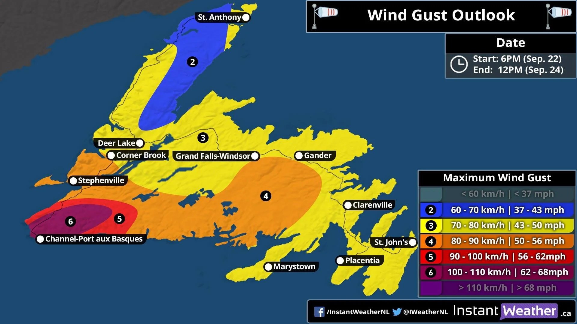
Winds in SW will be as high as 110 km/h, much of Western and Central will see Gusts up to 90 km/h, then further away, Northern Newfoundland, only up to 70 km/h and wide swath of up to 80 km/h for the Avalon, Burin Peninsula, Clarenville, Gander, GFW, Deer Lake, Corner Brook all will see Gusts up to 80 km/h.

With the Heavy rain and high winds, Scattered to widespread power outages is possible, The storm will arrive on Wednesday and last through Thursday.

Tropical Storm warnings are already in effect for South Western Newfoundland, large waves and rip currents, Storm surge is also expected.

Widespread Power Outages Likely as Teddy Quickly Approaches

Updated: September 22nd, 2020 @ 9:45 AM

Valid: September 22nd, 2020 @ 10 AM

Forecaster: James Follette

Power Outages Forecast.jpg

Latest thoughts on Power Outages:

A wide swath of wide spread power outages are very likely from Yarmouth to Sydney. We have possible and likely power outages for Western NS.

Power outages will be mainly caused by falling trees & branches, snapping power poles, high winds, and heavy rain.

Power outages could last a few to several days, similar to Hurricane Juan and Tropical Storm Arthur.

Be safe, everyone!