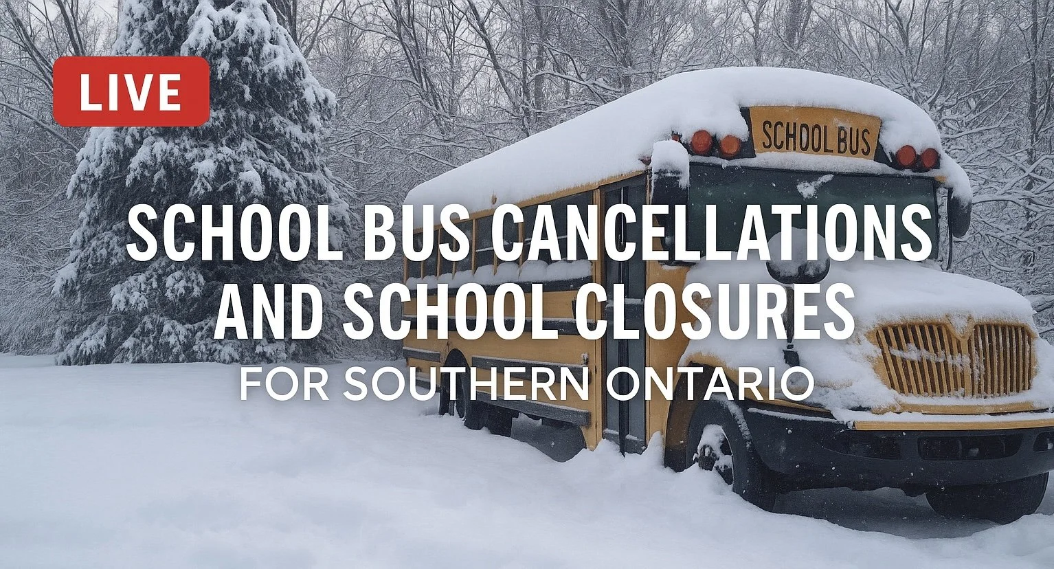
Southern Ontario: School Bus Cancellations and Closures for Thursday, January 15, 2026

**Please refresh your page every few minutes to receive the latest update**

Cancellation & Closure Map (English Public and Catholic Schools)

Please note: School board boundaries are a rough estimate. Don’t use this map to determine what school board or weather zone you live in as accuracy isn’t guaranteed.

  • Green = No Cancellations

  • Red = Cancellations (Click for More Details)

  • Purple = School Closures (Click for More Details)

List of Cancellations & Closures

English Public and Catholic Schools

  • Avon MaitIand Public & Huron-Perth CathoIic: All busses are cancelled and schools are closed.

  • BIuewater Public & Bruce-Grey Catholic: All busses are cancelled and schools are closed.

  • Dufferin-PeeI Catholic: All schools and offices/facilities are closed.

  • Durham Public & Durham Catholic: DSTS has cancelled all transportation for today.

  • Grand Erie Public & Brant HaIdimand Norfolk Catholic: All busses are cancelled and schools are closed.

  • Greater Essex Public & Windsor Essex CathoIic: All Board Provided Transportation is Cancelled for the day.

  • HaIton Public & Halton Catholic: All schools and administrative centres are closed and transportation services are cancelled.

  • HamiIton Wentworth Public & Catholic: All transportation has been cancelled for today and schools are closed.

  • Kawartha Pine Ridge Public & Peterborough Victoria Northumberland Clarington Catholic: All bus and transportation service is cancelled.

  • Lambton Kent Public & St. CIair Catholic: Busses in all zones are cancelled and schools are closed.

  • Niagara Public & Niagara Catholic: Student transportation is cancelled today and schools are closed.

  • Ottawa CarIeton Public & Ottawa Catholic: All school bus/van transportation is cancelled today.

  • PeeI Public: All Transportation is cancelled today and schools are closed.

  • Renfrew County Public & Renfrew County Catholic: Transportation services are CANCELLED for ALL AREAS.

  • Simcoe County Public & Simcoe Catholic: Busses are cancelled for the North, West, Central, and South Zones.

  • Thames Valley Public & London CathoIic: All busses are cancelled and schools are closed.

  • Toronto Public & Toronto Catholic: School Transportation is cancelled for all students and schools are closed.

  • Tri-Board: All school bus and taxi transportation is cancelled

  • Trillium LakeIands: Transportation to schools is not operating in Zones 3, 4, and 5.

  • Upper Canada Public & Eastern Ontario CathoIic: All transportation is cancelled

  • Upper Grand Public & Wellington CathoIic: All school taxis and buses will not be operating today and schools are closed.

  • WaterIoo Public & WaterIoo Catholic: All school buses, taxis and special education routes are cancelled and all schools are closed today.

  • York Public & York Catholic: All school bus and taxi transportation has been cancelled region-wide and schools are closed.

French Schools

  • Conseil des écoles publiques de l’Est de l’Ontario (CEPEO): All busses are cancelled.

  • Conseil catholique MonAvenir: Busses are cancelled for schools in: Durham, Norfolk, York, Wellington, Waterloo, Toronto, Simcoe, Peterborough, Peel, Niagara, Hamilton, Halton, and Brant. Some schools are closed.

  • Conseil scolaire de district catholique de l'Est Ontarien (CSDCEO): All busses are cancelled.

  • Conseil des écoles catholiques de langue française du Centre-Est: All busses are cancelled.

  • Conseil scolaire catholique Providence: All busses are cancelled.

  • Conseil scolaire Viamonde: All busses are cancelled and schools are closed in Niagara, Hamilton, Waterloo, Guelph, Orangeville, Peel, Halton, and Toronto.

High-Impact Snowstorm to Disrupt Thursday Morning Commute for Toronto, London, Ottawa and Eastern Ontario With Up to 20-40cm of Snow

NOTE: YOU CAN CLICK ON THE MAP TO OPEN A ZOOMABLE IMAGE

After a brief break from winter that allowed much of Southern Ontario to enjoy a bit of a so-called “January thaw”, it is becoming very clear that winter is far from finished. A sharp and notable cool down is now underway across the province, and by Thursday morning, temperatures will plunge well below seasonal levels.

Many areas across Southern Ontario will see air temperatures drop to near or below -15°C, and when the wind is factored in, it could feel closer to -20°C to -30°C in some communities.

While the bitter cold will certainly be noticeable, it will not be the main story over the next 24 to 36 hours. Attention now turns to a developing winter storm that forecast models have struggled to resolve right up until the last minute. This system is expected to spread a broad swath of steady snowfall across much of Southern Ontario, with the potential for significant impacts in highly populated and heavily travelled regions.

Earlier forecasts suggested this would be a fairly routine winter event, with snowfall amounts in the 5 to 15 centimetre range for the hardest hit areas. That type of snowfall is very common this time of year and would have resulted in some slow travel, but nothing overly disruptive. However, the latest model runs have dramatically shifted, showing a much stronger and more organized storm system taking shape.

Over the past several model cycles, guidance has intensified considerably. We are now tracking what could become the most widespread and impactful snowfall event of the season so far for parts of Southern Ontario. Some areas may see snowfall totals that rival or exceed anything experienced so far this winter.

Based on the latest data, we are now forecasting widespread snowfall totals in the 20 to 40 centimetre range across a large corridor stretching from Southwestern Ontario through the Golden Horseshoe and into Eastern Ontario.

Snow has already begun in some areas and is expected to continue intensifying through Wednesday evening, persisting through much of the day on Thursday before finally tapering off later in the afternoon or early evening.

This higher impact zone covers a very large portion of the province, including some of the most densely populated regions. This alone raises concerns about travel disruptions, school and business impacts, and the potential for extended cleanup times once the snow finally ends.

In addition to the steady system snowfall, there is also the potential for snow squalls to become embedded within the system. These are most likely to develop south of Lake Huron, particularly overnight into Thursday morning. Areas between Sarnia and London, including Lambton County and parts of Chatham-Kent, could see enhanced snowfall rates as lake enhancement adds extra moisture to the system.

The worst travel conditions are expected to occur overnight and into Thursday morning. By the time many people wake up, there will already be a substantial amount of snow on the ground, with steady snowfall ongoing. This sets the stage for a very difficult Thursday morning commute across much of Southern Ontario.

If travel can be avoided in the hardest hit areas, especially during the morning and early afternoon hours on Thursday, it would be strongly advised. For those who must travel, expect significant delays, poor visibility at times, and rapidly deteriorating road conditions, particularly in urban areas that have not yet seen a snowfall of this magnitude this season.

While there is growing agreement among models that a major snowfall event is likely, confidence is still not especially high when it comes to the exact placement of the heaviest bands. The forecast remains volatile, with some models continuing to shift the storm track slightly north or south. This has created a very sharp snowfall gradient, meaning small changes in the storm’s position could result in big differences in totals over short distances.

In some cases, communities could see over 20 centimetres of snow, while locations just 30 or 40 kilometres away may see less than half of that. This makes pinpointing exact totals extremely challenging and increases the risk of some areas either underperforming or significantly exceeding the forecast.

Hourly snowfall rates (cm) - MAP FROM WEATHERBELL

Snow has already begun across Deep Southwestern Ontario and will continue spreading northeastward through the evening. By around midnight, snowfall should be widespread across much of Southwestern Ontario and expanding into the Golden Horseshoe, including the Niagara region and western GTA.

For many locations, snowfall will begin as steady and moderate, gradually increasing in intensity through the overnight hours. Snowfall rates will generally sit around 1 to 2 centimetres per hour initially, which on its own may not seem overly concerning. The issue is the duration of the event, as these rates will persist for 12 hours or more in some areas, allowing snow to pile up over time.

The heaviest snowfall overnight is expected to be focused between Sarnia and London, where lake enhancement off Lake Huron may briefly boost snowfall rates higher. These heavier bursts could make travel especially difficult overnight and into the early morning hours.

Wind will also become a factor as the storm progresses. Gusts will increase to between 40 and 60 kilometres per hour in some areas overnight. When combined with falling snow, this will lead to blowing snow and reduced visibility, particularly in open and rural areas.

Hourly snowfall rates (cm) - MAP FROM WEATHERBELL

Conditions are expected to continue deteriorating into Thursday morning as snowfall intensity increases across much of the Golden Horseshoe. Areas from London through Hamilton and into the Greater Toronto Area could see periods of heavier snow during the morning hours. In the most intense bands, snowfall rates may briefly reach 2 to 4 centimetres per hour, which will make it very difficult for road crews to keep up.

Unfortunately, this lines up almost perfectly with the Thursday morning rush hour. Travel across the GTA and surrounding regions will be extremely slow, and in some cases nearly impossible, especially on secondary roads. If you can delay travel or work from home, Thursday morning would be an ideal time to do so.

Snow will also spread into Eastern Ontario overnight and early Thursday morning. The Ottawa area is expected to see snow arrive around or just before the morning commute, with conditions worsening through the late morning and early afternoon hours.

One of the most important details we are still watching closely is the northern cutoff of the heaviest snow. As shown on the forecast map, there is a sharp transition zone near areas such as Barrie and Peterborough. The American HRRR model suggests that locations just north of this line may see very little snow, while those south of it could see totals exceeding 20 centimetres.

Other model solutions shift this cutoff further south, which would place parts of the GTA closer to the lower snowfall edge. Meanwhile, some guidance shifts it further north, allowing areas like Barrie and Peterborough to see much higher totals. This uncertainty is why confidence drops significantly near this transition zone.

WIND CHILL - MAP FROM WEATHERBELL

Another key factor enhancing snowfall totals is the colder air moving in behind the system. By Thursday morning, many parts of Southern Ontario will feel like -20°C or colder once you factor in the wind chill.

As temperatures drop, the snow becomes lighter and fluffier. Colder air allows snowflakes to be less dense, which means the same amount of moisture can produce more snow on the ground. This is known as a higher snow-to-liquid ratio, and it is one reason totals may end up higher than initially expected.

Hourly snowfall rates (cm) - MAP FROM WEATHERBELL

Through the late morning hours on Thursday, heavy snow is expected to continue across the Golden Horseshoe while spreading further east into Eastern Ontario.

In the west, areas near Lake Huron and Deep Southwestern Ontario should begin to see snowfall gradually taper off toward the end of the morning.

By around noon, steady snow should still be falling from the Golden Horseshoe eastward into Eastern Ontario. The Niagara region and eastern portions of the GTA may remain under heavier snowfall for the first part of the afternoon before intensity slowly begins to decrease.

Hourly snowfall rates (cm) - MAP FROM WEATHERBELL

Eastern Ontario may end up seeing the worst conditions during the early to mid-afternoon hours. Snowfall rates here are expected to range between 1 and 3 centimetres per hour and could linger for several hours before tapering off later in the day.

Snow should finally begin to move out of most areas by late afternoon or early evening, though a few lingering flurries may persist into the evening across Eastern Ontario.

NOTE: YOU CAN CLICK ON THE MAP TO OPEN A ZOOMABLE IMAGE

The most challenging aspect of this storm remains the tight snowfall gradient. Small shifts in storm track will make a big difference in totals, and models continue to disagree on exactly where that cutoff will set up. This means forecast amounts could change with little notice.

After reviewing all available guidance, we have put together a snowfall forecast that reflects the most likely scenario based on the majority of model data. However, this is one of those events where nearly every model offers a slightly different outcome, and it would not take much for totals to shift in either direction.

The highest snowfall totals appear most likely in a corridor stretching from Sarnia through London, across the entire Golden Horseshoe, and into Eastern Ontario, including the Ottawa Valley. These areas can expect widespread totals of 20 to 40 centimetres, with isolated pockets possibly approaching or exceeding 50 centimetres.

This includes communities such as Sarnia, Chatham, London, Woodstock, Tillsonburg, Brantford, Niagara Falls, Hamilton, Kitchener, Guelph, Mississauga, Toronto, Oshawa, Belleville, Tweed, Kingston, Smiths Falls, Renfrew, Ottawa, Brockville and Cornwall.

Slightly lower totals in the 10 to 20 centimetre range are expected for areas like Windsor, Leamington, Grand Bend, Goderich, Hanover, Orangeville, Newmarket, Peterborough and Bancroft. This is also the zone with the lowest confidence, as some of these locations could end up with significantly more or less snow depending on where the cutoff ultimately sets up.

Further north and west, snowfall amounts drop off quickly. Areas such as Owen Sound, Barrie and Pembroke are expected to see less than 10 centimetres of accumulation, with little to no snowfall expected north of Orillia.

These totals remain subject to change, and adjustments are likely as the storm unfolds. We will be closely monitoring conditions throughout Thursday and will provide real-time updates as we see how the storm is evolving on radar and through observations.

‘Snow Day’ Forecast: Major Snowstorm Almost Certain to Cancel School Buses in Much of Southern Ontario on Thursday

For an updated list of school bus cancellations & school closures, please visit our live article: https://instantweatherinc.com/article/2026/1/15/bus-cancellations

Enter to Win a 7-Night Cruise for 2 with Celebrity Cruises, Including Airfare - Select Patricia Bootsma as your travel consultant

NOTE: YOU CAN CLICK ON THE MAP TO OPEN A ZOOMABLE IMAGE

A last-minute shift in forecast models has placed much of Southern Ontario in the crosshairs of a prolonged snowstorm expected to begin Wednesday evening and continue through much of Thursday. This system has the potential to be impactful, with snowfall totals exceeding 20 cm in some areas by the time it winds down late Thursday.

Environment Canada has responded by issuing widespread snowfall warnings stretching from parts of Eastern and Central Ontario through the Golden Horseshoe. At the same time, snow squall warnings have been issued for areas south of Lake Huron and Georgian Bay, adding another layer of complexity to this already active setup.

In addition to the snow, very cold Arctic air is expected to surge into Southern Ontario overnight into Thursday morning. Wind chills could approach minus 30 degrees in some areas, especially during the early morning hours.

This combination of heavy snow, blowing snow and dangerous cold is almost certain to disrupt travel and will very likely lead to widespread school bus cancellations. In some regions, school closures may also need to be considered.

The highest confidence for a snow day is found across the more rural school boards that are typically the most sensitive to adverse winter weather. With active snowfall warnings in place and significant accumulation expected, thresholds will almost certainly be met.

We have assigned a 90 percent chance to all areas covered by Tri-Board Student Transportation Services, all of Kawartha Pine Ridge District School Board, the South Kawartha Lakes region under the Trillium Lakelands District School Board, and Wellington and Dufferin counties within the Upper Grand District School Board.

A much broader area falls into the strong likelihood category, with a 75 percent chance of a snow day. This includes the Upper Canada District School Board and the Renfrew County District School Board, Haliburton County and North Kawartha Lakes under TLDSB, North Durham within the Durham District School Board, York Region District School Board, the Simcoe Central, Simcoe South and Simcoe West zones under the Simcoe County District School Board, northern Peel Region, northern Halton, Hamilton-Wentworth, Niagara Region, Guelph within the Upper Grand District School Board, Waterloo Region, Oxford County and Middlesex County under the Thames Valley District School Board, Lambton County within the Lambton Kent District School Board, Perth County under the Avon Maitland District School Board, and the Hanover, Meaford, Owen Sound and Bruce Peninsula areas within the Bluewater District School Board.

While we expect most of these school boards to cancel buses, there remains a small chance that a few could attempt to operate if snowfall rates are lighter than expected early Thursday morning. That said, confidence remains high that cancellations will be widespread within this zone.

For more urban school boards, confidence becomes less certain. Areas including Ottawa under the Ottawa Student Transportation Authority, southern Durham Region within the Durham District School Board, Toronto District School Board, southern Peel Region, southern Halton, and the Grand Erie District School Board have been assigned a 50 percent chance. The snowfall amounts currently mentioned in Environment Canada alerts sit right on the threshold that typically prompts cancellations for these boards. Some forecast guidance suggests totals could exceed what is currently advertised, and if that materializes, cancellations would become more likely in these areas.

Other regions sitting firmly in the toss-up category include Simcoe North, South Muskoka under the Trillium Lakelands District School Board, Southampton and Kincardine within the Bluewater District School Board, Huron County under the Avon Maitland District School Board, London and Elgin County for the Thames Valley District School Board, and Chatham-Kent and Sarnia within the Lambton Kent District School Board. These areas sit closer to the edge of the heaviest snowfall, and it remains questionable whether enough accumulation will occur to prompt cancellations.

A slight chance, around 25 percent, has been assigned to Essex County within the Greater Essex County District School Board. At this time, no weather alerts are in place for this region, but if snowfall amounts trend higher than expected overnight, a limited number of cancellations could occur.

We have also assigned a 25 percent chance to North Muskoka under the Trillium Lakelands District School Board, along with Parry Sound and East Parry Sound within the Near North District School Board. These regions are expected to remain largely outside the core of the storm, but if the system tracks farther north than currently forecast, cancellations could become more likely, particularly given Near North’s tendency to respond proactively to winter weather.


Disclaimer: Instant Weather has zero authority when it comes to bus and school closures.

It is completely up to the school boards, bus companies, local authorities, and parents to decide what is best for their children. This is our best guess based on our forecast.

‘Snow Day’ Forecast: Flash Freeze Risk Brings Slight Chance of School Bus Cancellations in Parts of Southern Ontario on Wednesday

Enter to Win a 7-Night Cruise for 2 with Celebrity Cruises, Including Airfare - Select Patricia Bootsma as your travel consultant

NOTE: YOU CAN CLICK ON THE MAP TO OPEN A ZOOMABLE IMAGE

Rapidly plunging temperatures followed by the development of snow squall activity are expected across Southern Ontario throughout the day on Wednesday, creating a potentially tricky setup when it comes to school transportation.

As a strong cold front sweeps across the region beginning Wednesday morning, temperatures are expected to fall sharply in a short period of time. In some areas, readings could drop from a few degrees above freezing to well below minus 10 degrees within just a few hours. This raises the risk of a flash freeze, particularly on untreated roads, sidewalks and rural routes.

Because of this flash freeze potential, there is a possibility that some school boards may choose to cancel buses, especially in rural areas that are more sensitive to icy conditions. These boards rely heavily on extensive backroad routes, where surfaces can quickly become dangerous once temperatures drop below freezing.

One of the complicating factors with this setup is timing. In many parts of Southern Ontario, temperatures are not expected to begin falling sharply until the late morning or early afternoon. That means any cancellations would need to be made proactively, based on expected conditions later in the day, rather than what is occurring at the time of the morning bus run. Historically, this type of proactive decision-making can vary significantly from one school board to another.

If Environment Canada issues a flash freeze warning by early Wednesday morning, the probability of cancellations would increase fairly rapidly. Flash freeze warnings tend to carry more weight with school boards, as they highlight a rapid deterioration in road conditions that can catch drivers off guard.

At this time, the highest chance for bus cancellations includes all regions covered by the Bluewater District School Board and the Near North District School Board. We have assigned these areas a slight chance, around 25 percent. These boards are expected to be among the first to experience the temperature drop as the cold front pushes in from the northwest.

Current indications suggest the front could arrive as early as 4 to 6 AM in these areas, which increases the likelihood that icy conditions could already be developing during the morning commute. In addition, Environment Canada snow squall watches mentioning squalls developing later in the day may give the Bluewater District School Board additional reason to consider cancellations.

Across the rest of Southwestern, Central and Eastern Ontario, we have gone with a widespread low to very low chance of school bus cancellations, generally in the 5 to 10 percent range. The slightly higher end of that range is focused on regions under snow squall watches or rural school boards that historically respond more cautiously to flash freeze situations.

At this point, we do not believe the snow squall watches alone will be enough to prompt cancellations on Wednesday, as the bulk of the squall activity is expected to begin after the school day has ended. However, this setup does raise concerns heading into Thursday, when snow squalls are expected to ramp up late Wednesday and continue into the following day.

For the remainder of Southern Ontario, the chance of school bus cancellations remains under 5 percent. Weather conditions in these areas are not expected to reach the threshold that typically leads to cancellations, and most school boards should be able to operate normally on Wednesday.


Disclaimer: Instant Weather has zero authority when it comes to bus and school closures.

It is completely up to the school boards, bus companies, local authorities, and parents to decide what is best for their children. This is our best guess based on our forecast.

Southern Ontario: ‘Snow Day’ Forecast for Tuesday, January 13, 2026

NOTE: YOU CAN CLICK ON THE MAP TO OPEN A ZOOMABLE IMAGE

Aside from some light flurries east of Georgian Bay extending into parts of Eastern Ontario, which are expected to taper off through the evening, no impactful winter weather is anticipated overnight and during the school day on Tuesday.

Because of this, we are not expecting any school bus cancellations, and all regions across Southern Ontario have been assigned less than a 5 percent chance.

There remains a very small chance of isolated cancellations in parts of Central and Eastern Ontario, particularly within rural school boards, if backroads become icy as temperatures hover near the freezing mark.

However, this would come down to highly localized road conditions rather than active weather. Since this type of scenario is not directly driven by forecasted weather impacts, it is not factored into our snow day forecast.


Disclaimer: Instant Weather has zero authority when it comes to bus and school closures.

It is completely up to the school boards, bus companies, local authorities, and parents to decide what is best for their children. This is our best guess based on our forecast.

Southern Ontario: ‘Snow Day’ Forecast for Monday, January 12, 2026

NOTE: YOU CAN CLICK ON THE MAP TO OPEN A ZOOMABLE IMAGE

No major winter weather is expected across Southern Ontario on Monday, which means school bus cancellations are very unlikely in most areas.

A weak system, being enhanced by Lake Huron and Georgian Bay, may bring a few centimetres of snowfall during the morning and early afternoon. This could briefly reduce visibility in some localized areas, particularly closer to the lakes.

That said, snowfall amounts are not expected to reach the threshold that typically prompts cancellations. If any decisions are made, they would most likely be in parts of Grey-Bruce, the Parry Sound area or Muskoka. For that reason, we have assigned these regions a low to very low chance, but the overall expectation is that buses will run as normal.

For the rest of Southern Ontario, the chance of a snow day remains under 5 percent on Monday.


Disclaimer: Instant Weather has zero authority when it comes to bus and school closures.

It is completely up to the school boards, bus companies, local authorities, and parents to decide what is best for their children. This is our best guess based on our forecast.

Southern Ontario: ‘Snow Day’ Forecast for Friday, January 9, 2026

NOTE: YOU CAN CLICK ON THE MAP TO OPEN A ZOOMABLE IMAGE

Milder weather is expected across Southern Ontario throughout Friday, with temperatures remaining well above the freezing mark.

Any precipitation that develops on Friday will fall as plain rain and is not expected to create any travel issues or hazardous road conditions.

Because of this, all of Southern Ontario carries less than a 5 percent chance of a snow day on Friday.

It looks like homework is in the forecast for tonight!


Disclaimer: Instant Weather has zero authority when it comes to bus and school closures.

It is completely up to the school boards, bus companies, local authorities, and parents to decide what is best for their children. This is our best guess based on our forecast.

Southern Ontario: ‘Snow/Fog Day’ Forecast for Thursday, January 8, 2026

NOTE: YOU CAN CLICK ON THE MAP TO OPEN A ZOOMABLE IMAGE

While no major winter weather conditions are expected to impact travel across Southern Ontario on Thursday morning, weather conditions may still be less than ideal in some areas. Patchy fog is expected to develop overnight and could linger into the early morning hours, particularly in rural regions.

If fog becomes dense enough, it could significantly reduce visibility on roadways. This raises the possibility of a few scattered school bus cancellations, mainly in parts of Southwestern, Central and Eastern Ontario. These regions tend to be more sensitive to fog-related impacts, especially where rural routes, open fields and low-lying areas allow visibility to drop quickly.

That said, confidence remains fairly low when it comes to pinpointing exactly where cancellations may occur. Fog events can be highly localized, and small shifts in wind or temperature overnight can make the difference between clear conditions and dense fog by morning. Because of that uncertainty, this is not a high-confidence forecast for any one region.

To account for this, we have assigned a widespread 25 percent chance for what could be considered a “fog day” on Thursday in areas where school boards have historically shown a willingness to cancel when visibility becomes an issue. This includes Lambton and Chatham-Kent under the Lambton Kent District School Board, Middlesex, Elgin and Oxford counties within the Thames Valley District School Board, and all regions covered by the Avon Maitland District School Board.

This 25 percent zone also includes Wellington and Dufferin counties under the Upper Grand District School Board, most of the Bluewater District School Board, excluding in-city routes in Owen Sound, Parry Sound and East Parry Sound within the Near North District School Board, and North and Central Hastings, along with North and Central Lennox and Addington under Tri-Board Student Transportation Services. While most of these regions will likely see buses running as normal, a few localized cancellations are possible depending on where fog is most persistent.

Outside of these areas, the rest of Southern Ontario carries a low to very low chance of school bus cancellations. A surprise decision cannot be completely ruled out, but confidence is low that fog will become dense enough or widespread enough to justify cancellations in these regions.

Urban school boards across the Golden Horseshoe and the Ottawa area are especially unlikely to see any disruptions. Fog rarely leads to cancellations in highly urbanized regions, where road networks are better lit, more heavily travelled and less dependent on long rural bus routes.


Disclaimer: Instant Weather has zero authority when it comes to bus and school closures.

It is completely up to the school boards, bus companies, local authorities, and parents to decide what is best for their children. This is our best guess based on our forecast.

Southern Ontario: School Bus Cancellations and Closures for Wednesday, January 7, 2026

**Please refresh your page every few minutes to receive the latest update**

Cancellation & Closure Map (English Public and Catholic Schools)

Please note: School board boundaries are a rough estimate. Don’t use this map to determine what school board or weather zone you live in as accuracy isn’t guaranteed.

  • Green = No Cancellations

  • Red = Cancellations (Click for More Details)

  • Purple = School Closures (Click for More Details)

List of Cancellations & Closures

English Public and Catholic Schools

  • Dufferin-PeeI Catholic: Buses to St. Andrew, St. Peter, St. Benedict as well as Duffern County buses to Robert F. Hall CSS are cancelled today

  • Kawartha Pine Ridge Public & Peterborough Victoria Northumberland Clarington Catholic: Transportation is cancelled in Northumberland County today

  • PeeI Public: Some gravel or rural roads in Caledon might not be serviced today. Monitor https://businfo.stopr.ca/Cancellations.aspx for updates

  • Simcoe County Public & Simcoe Catholic: Busses are cancelled in the South Zone.

  • Thames Valley Public & London CathoIic: Busses are cancelled in Oxford County.

  • Tri-Board: All school bus and taxi transportation is cancelled today.

  • Upper Canada Public & Eastern Ontario CathoIic: All transportation is cancelled

  • Upper Grand Public & Wellington CathoIic: All school taxis and buses in Division 3 (North Wellington) and Division 4 (Dufferin County and Robert F. Hall) will not be operating today.

French Schools

  • Conseil des écoles publiques de l’Est de l’Ontario (CEPEO): All CTSE busses are cancelled. CTSO busses are cancelled for Kingston, Trenton, Brockville, Kemptville, Marionville and Presscott-Russell.

  • Conseil catholique MonAvenir: Busses are cancelled for some schools in Simcoe

  • Conseil scolaire de district catholique de l'Est Ontarien (CSDCEO): All busses are cancelled.

  • Conseil des écoles catholiques de langue française du Centre-Est: Busses are cancelled for Kingston, Trenton, Brockville, Kemptville, Marionville and Presscott-Russell.

  • Conseil scolaire catholique Providence: Busses are cancelled in Simcoe South and Oxford.

  • Conseil scolaire Viamonde: Busses are cancelled in Simcoe South and Oxford.

‘Snow Day’ Forecast: Some Parts of Southern Ontario May See a Third Day of Bus Cancellations on Wednesday

For an updated list of school bus cancellations & school closures, please visit our live article: https://instantweatherinc.com/article/2026/1/7/bus-cancellations

NOTE: YOU CAN CLICK ON THE MAP TO OPEN A ZOOMABLE IMAGE

A messy system has been delivering a whiplash of winter weather across Southern Ontario throughout the day on Tuesday. Precipitation has ranged from freezing rain to ice pellets, with conditions expected to transition over to heavier snow in some areas through the evening.

While the core of this system is forecast to wind down later this evening and into the early overnight hours, its impacts are expected to linger into Wednesday morning. For regions that have dealt with prolonged periods of freezing rain, there is little indication of a meaningful warmup overnight. This means any ice that has formed on untreated surfaces is unlikely to melt, leaving roads, sidewalks and driveways slippery heading into the morning commute.

Because of this, we have fairly high confidence that some school bus cancellations will occur on Wednesday, particularly in rural areas with extensive backroad networks. These routes can remain icy well after precipitation ends, especially when temperatures stay below freezing. In addition to icing concerns, thick fog is expected to develop in parts of Southwestern Ontario overnight, which could further reduce visibility and contribute to cancellations or delays.

The highest chance for a snow or ice day includes Kingston, South Frontenac, South and Central Lennox and Addington, and Belleville under Tri-Board Student Transportation Services, along with Peterborough and Northumberland counties within the Kawartha Pine Ridge District School Board.

These regions tend to be among the most sensitive to poor backroad conditions due to their large rural coverage. They are also expected to see freezing rain linger the longest, leaving less time for road crews to fully clear conditions before the morning bus run. As a result, we have assigned these areas a 75 percent chance of bus cancellations.

Much of the remaining rural portion of Central Ontario into Southwestern Ontario falls into the toss-up category. We expect several school boards in this zone to keep buses off the roads, but decisions will likely come down to highly localized road conditions and how much additional icing occurs overnight.

This includes the remainder of Tri-Board Student Transportation Services, the Madawaska region within the Renfrew County District School Board, most of the Trillium Lakelands District School Board excluding North Muskoka, and the Simcoe North weather zone under the Simcoe County District School Board.

Rural school boards across Southwestern Ontario may also be impacted by the development of thick fog overnight, combined with lingering icy conditions in higher elevation areas that saw freezing rain earlier Tuesday.

Because of this, we have also assigned a 50 percent chance to several boards in this region, although confidence here is slightly lower. Outcomes will depend on how dense and widespread the fog becomes by morning.

This group includes Dufferin and Wellington counties within the Upper Grand District School Board, Grey County under the Bluewater District School Board, Perth County for the Avon Maitland District School Board, and Middlesex and Oxford counties within the Thames Valley District School Board.

A slight chance, around 25 percent, has been assigned to the rural portions of the Ottawa Valley, including areas covered by the Upper Canada District School Board and the Renfrew County District School Board. Icing here has been more limited, making cancellations questionable, but a few isolated decisions cannot be ruled out if conditions deteriorate overnight.

We have also assigned a 25 percent chance to the remainder of Simcoe County, along with Georgina under the York Region District School Board. These areas are more urban and typically maintain a higher threshold for cancellations, so decisions will depend on whether road conditions are poor enough early Wednesday morning to justify keeping buses off the roads.

In Southwestern Ontario, a 25 percent chance has been given to the Waterloo Region District School Board, Guelph within the Upper Grand District School Board, Elgin County under the Thames Valley District School Board, Lambton County for the Lambton Kent District School Board, Huron County within the Avon Maitland District School Board, and southern Bruce County under the Bluewater District School Board.

Patchy fog is possible in these regions, but confidence in its extent is lower, and several of these boards are less likely to cancel based on fog or marginal backroad issues alone.

Elsewhere across Southern Ontario, including Ottawa and the more urban school boards throughout the Golden Horseshoe and into Deep Southwestern Ontario, the chance of bus cancellations remains low.

That said, if there are any surprises, they may come from parts of Deep Southwestern Ontario, including Windsor, Sarnia and Chatham. Some forecast guidance suggests fog could extend into these areas overnight, which may prompt a small number of unexpected cancellations if visibility becomes an issue.


Disclaimer: Instant Weather has zero authority when it comes to bus and school closures.

It is completely up to the school boards, bus companies, local authorities, and parents to decide what is best for their children. This is our best guess based on our forecast.

Southern Ontario: School Bus Cancellations and Closures for Tuesday, January 6, 2026

**Please refresh your page every few minutes to receive the latest update**

Cancellation & Closure Map (English Public and Catholic Schools)

Please note: School board boundaries are a rough estimate. Don’t use this map to determine what school board or weather zone you live in as accuracy isn’t guaranteed.

  • Green = No Cancellations

  • Red = Cancellations (Click for More Details)

  • Purple = School Closures (Click for More Details)

List of Cancellations & Closures

English Public and Catholic Schools

  • BIuewater Public & Bruce-Grey Catholic: All busses are cancelled EXCEPT for Zone 7 (Teeswater, Lucknow, Ripley)

  • Dufferin-PeeI Catholic: Buses in STOPR Zone 3 and buses to St. Andrew, St. Peter, St. Benedict, and Robert F. Hall CSS are cancelled today due to forecasted road and weather conditions.

  • Durham Public & Durham Catholic: DSTS has cancelled all transportation for today due to inclement weather.

  • HaIton Public & Halton Catholic: Transportation services are cancelled in all Zones.

  • Kawartha Pine Ridge Public & Peterborough Victoria Northumberland Clarington Catholic: Bus and transportation service is cancelled to ALL schools in the STSCO jurisdiction for the day.

  • PeeI Public: All Transportation in Zone 3 is cancelled today.

  • Renfrew County Public & Renfrew County Catholic: Zone 4 Madawaska area transportation services ONLY are cancelled due to the afternoon weather forecast.

  • Simcoe County Public & Simcoe Catholic: All busses are cancelled.

  • Tri-Board: Transportation is cancelled in Tri-Board’s Prince Edward County, Belleville & Quinte West, Centre Hastings, South Lennox & Addington, Central Lennox & Addington weather zones today.

  • Trillium LakeIands: Transportation to schools is not operating in Zone 1, 4, and 5 today.

  • Upper Grand Public & Wellington CathoIic: All school taxis and buses will not be operating today.

  • York Public & York Catholic: School bus and taxi transportation has been cancelled Region-wide today.

French Schools

  • Conseil des écoles publiques de l’Est de l’Ontario (CEPEO): Busses are cancelled for Trenton

  • Conseil catholique MonAvenir: Busses are cancelled for schools in Durham, York, Wellington, Simcoe, Peterborough, and Halton

  • Conseil des écoles catholiques de langue française du Centre-Est: Busses are cancelled for Trenton.

  • Conseil scolaire catholique Providence: Busses are cancelled for York, Simcoe, Halton, Durham and Bruce-Grey Regions

  • Conseil scolaire Viamonde: Busses are cancelled for York, Simcoe, Halton, Durham, and Bruce-Grey Regions

Southern Ontario Faces Ice Threat Then Snow as Fast Moving Winter System Disrupts Tuesday Travel

NOTE: YOU CAN CLICK ON THE MAP TO OPEN A ZOOMABLE IMAGE

A fast changing winter system is expected to sweep through much of Southern Ontario during the day on Tuesday, bringing a messy mix of precipitation types and rapidly changing conditions. While this is not expected to be a blockbuster storm on its own, the combination of freezing rain followed by snow could still create localized impacts, especially during the afternoon and evening hours.

The first part of this system will arrive Tuesday morning and early afternoon, with freezing rain becoming the dominant concern for several regions. Widespread freezing rain is expected to develop across the higher elevations northwest of the GTA, extending into areas north of Lake Simcoe and along the Lake Ontario shoreline from Peterborough eastward toward Kingston. These elevated regions tend to hang onto colder air longer, making them more vulnerable to icing during marginal setups like this one.

Freezing rain is expected to begin developing across parts of Southwestern Ontario east of Lake Huron, including the Kitchener area and the Dundalk Highlands, by the late morning hours on Tuesday. From there, the freezing rain shield is forecast to spread north and eastward through the afternoon, reaching areas around Lake Simcoe such as Barrie, along with York Region, Durham Region, Kawartha Lakes, Peterborough and eventually Kingston.

In some locations, the precipitation may initially fall as ice pellets during the early afternoon before transitioning over to freezing rain for a few hours. This could help slightly limit ice accretion at first, but any freezing rain will still make untreated roads, sidewalks and elevated surfaces quite slick as temperatures remain near or below freezing.

For the GTA, the freezing rain threat looks more limited, but it cannot be ruled out entirely. There could be an hour or two of freezing rain during the afternoon, especially in the northern parts of the region, before precipitation transitions over to light snow by the evening. Meanwhile, areas in Deep Southwestern Ontario and the Niagara region are expected to remain mostly on the rain side of this system, with temperatures hovering in the low single digits above freezing for much of the event.

One of the more unusual aspects of this system is what happens after the freezing rain ends. While ice accretion amounts are expected to generally remain manageable, in the range of 2 to 5 millimetres for areas northwest of the GTA into Simcoe County and eastward through Peterborough and Kingston, there will not be a quick or clean warm-up. Instead, colder air is expected to surge back in, overpowering the warm layer aloft.

NOTE: YOU CAN CLICK ON THE MAP TO OPEN A ZOOMABLE IMAGE

As this colder air deepens, precipitation is forecast to transition back to snow by the early evening and continue into the overnight hours across Central and Eastern Ontario, as well as the higher elevations northwest of the GTA. This changeover could happen fairly quickly once it begins, leading to periods of steady snowfall through Tuesday night.

Snowfall totals from this second phase of the system are expected to range from 5 to 10 centimetres across many of the same areas that experienced freezing rain earlier in the day. This includes parts of Simcoe County, Kawartha Lakes, Peterborough and areas toward Kingston, as well as elevated terrain northwest of the GTA.

While neither the ice accretion nor the snowfall amounts are particularly extreme on their own, the combined impact could be more significant. Even light ice accretion can weaken tree branches and add extra weight to power lines, and when followed by several centimetres of heavy, wet snow, the risk of isolated power outages and downed branches increases.

Elsewhere, including the GTA, regions east of Lake Huron and parts of northern Central and Eastern Ontario, snowfall totals are expected to be lighter, generally in the 2 to 5 centimetre range. This should still be enough to create slick travel conditions Tuesday evening and overnight, especially as temperatures drop back below freezing.

For the Ottawa region, this system looks less impressive overall. Precipitation amounts appear limited, and snowfall totals may struggle to reach the 2 centimetre mark by the time everything wraps up.

As always with systems like this, small changes in temperature can make a big difference in precipitation type and impacts. Drivers should be prepared for rapidly changing road conditions throughout the day on Tuesday, especially in areas that see freezing rain followed by accumulating snow.

‘Snow (Ice) Day’ Forecast: Risk of Freezing Rain on Tuesday Could Cancel School Buses in Parts of Southern Ontario

For an updated list of school bus cancellations & school closures, please visit our live article: https://instantweatherinc.com/article/2026/1/6/bus-cancellations

NOTE: YOU CAN CLICK ON THE MAP TO OPEN A ZOOMABLE IMAGE

A messy and potentially disruptive system is expected to move through Southern Ontario on Tuesday, bringing with it the risk of several hours of freezing rain developing from the late morning into the afternoon.

Environment Canada has issued widespread freezing rain warnings and special weather statements ahead of this system, highlighting the threat of icing beginning Tuesday morning and continuing through much of the day. With freezing rain notoriously difficult to deal with on untreated surfaces, there is growing concern that some school boards may opt to cancel buses, particularly across rural areas northwest of the Greater Toronto Area and into portions of Central and Eastern Ontario.

What makes this event especially tricky from a school transportation perspective is the timing. The bulk of the freezing rain is not expected to begin until after the morning bus run has already wrapped up. That means any cancellations would need to be made proactively, based largely on Environment Canada alerts and the expectation of deteriorating conditions during the afternoon dismissal. Historically, that level of proactiveness can vary quite a bit from one school board to another.

Because of that uncertainty, we have capped the highest probability at 50 percent, reflecting the fact that this could truly go either way. This 50 percent zone includes Middlesex and Oxford counties under the Thames Valley District School Board, Perth County within the Avon Maitland District School Board, Wellington and Dufferin counties for the Upper Grand District School Board, and the Kincardine, Hanover and Meaford regions under the Bluewater District School Board. These areas are more rural in nature, tend to respond more cautiously to freezing rain threats, and are currently covered by freezing rain warnings. While no single region stands out as a sure thing for cancellations, we do have fairly strong confidence that at least a few boards will declare an “ice day” on Tuesday.

We have also included Peterborough and Northumberland counties under the Kawartha Pine Ridge District School Board, along with the southern portions of Tri-Board Student Transportation Services, in the 50 percent category. These areas are currently under special weather statements rather than full warnings, but these school boards have a history of being particularly proactive when freezing rain is involved. In some cases, even a special weather statement can be enough to prompt cancellations.

A broader area has been assigned a 25 percent chance, covering much of Southwestern Ontario and extending into parts of Central and Eastern Ontario. This includes the Greater Essex County District School Board, the Lambton Kent District School Board, London and Elgin County within the Thames Valley District School Board, Huron County under the Avon Maitland District School Board, Owen Sound, Southampton and the Bruce Peninsula for the Bluewater District School Board, Waterloo Region, Guelph under the Upper Grand District School Board, the Simcoe County District School Board, North and South Kawartha Lakes under the Trillium Lakelands District School Board, and the remaining portions of Tri-Board. In these areas, freezing rain is either expected to be patchy or brief, but given the timing and potential for slick roads, a few surprise cancellations cannot be ruled out.

Outside of this zone, including the more urban school boards across the Golden Horseshoe, the Ottawa Valley and Northeastern Ontario, the chance of school bus cancellations drops to low or very low. In some cases, these regions are simply too far removed from the core freezing rain threat, as is the case for parts of Northeastern Ontario and the Ottawa Valley. In other cases, the boards are highly urbanized and typically require more widespread or severe icing before cancellations are considered.


Disclaimer: Instant Weather has zero authority when it comes to bus and school closures.

It is completely up to the school boards, bus companies, local authorities, and parents to decide what is best for their children. This is our best guess based on our forecast.

Southern Ontario: School Bus Cancellations and Closures for Monday, January 5, 2026

**Please refresh your page every few minutes to receive the latest update**

Cancellation & Closure Map (English Public and Catholic Schools)

Please note: School board boundaries are a rough estimate. Don’t use this map to determine what school board or weather zone you live in as accuracy isn’t guaranteed.

  • Green = No Cancellations

  • Red = Cancellations (Click for More Details)

  • Purple = School Closures (Click for More Details)

List of Cancellations & Closures

English Public and Catholic Schools

  • Avon MaitIand Public & Huron-Perth CathoIic: There are several cancellations, please visit this link for more details: https://hpsts.mybusplanner.ca/Alerts

  • BIuewater Public & Bruce-Grey Catholic: All busses are cancelled.

  • Kawartha Pine Ridge Public & Peterborough Victoria Northumberland Clarington Catholic: Bus and transportation service is cancelled to ALL schools in the STSCO jurisdiction for the day.

  • Tri-Board: All school bus and taxi transportation is cancelled in the Tri-Board Student Transportation Services area today.

French Schools

  • Conseil des écoles publiques de l’Est de l’Ontario (CEPEO): Busses are cancelled for Kingston and Trenton

  • Conseil catholique MonAvenir: Busses are cancelled for schools in Durham and Peterborough

  • Conseil des écoles catholiques de langue française du Centre-Est: Busses are cancelled for Kingston and Trenton

  • Conseil scolaire catholique Providence: Busses are cancelled in Bruce-Grey

  • Conseil scolaire Viamonde: Busses are cancelled in Bruce-Grey

Quick Blast of Heavy Snow May Impact the Morning Commute in Southern Ontario With Up to 15cm of Snow on Monday

NOTE: YOU CAN CLICK ON THE MAP TO OPEN A ZOOMABLE IMAGE

It has certainly been a busy start to 2026 across parts of Southern Ontario, especially in the snowbelt regions. Relentless snow squalls over the past week have brought widespread travel disruptions along with staggering snowfall totals, with some areas picking up an incredible 50 to 100cm of snow in a relatively short period of time.

While we managed to catch a bit of a break through the weekend, that quieter stretch will be short-lived. The first full week of the new year is shaping up to be an active one, with several rounds of messy winter weather expected to move through Southern Ontario over the next few days.

The next system arrives early Monday in the form of a fast-moving Alberta clipper. Unfortunately, the timing could not be much worse. With many people heading back to work and school after the holiday break, this system is expected to sweep through during the heart of the Monday morning commute.

Snow is expected to break out across Southwestern Ontario and quickly expand northeastward into Central Ontario and the Golden Horseshoe. While this will not be a major snowfall event by snowbelt standards, the intensity and timing of the snow could still cause notable travel issues.

Snowfall totals are not expected to be extreme, especially compared to what areas east of Lake Huron and southeast of Georgian Bay have been dealing with recently.

However, widespread amounts of 8 to 15cm are possible in the hardest hit regions. The key factor here is that much of this snow is expected to fall within just a few hours, which significantly increases its impact compared to a longer duration, lighter snowfall.

This clipper system is expected to move through fairly quickly, with conditions gradually improving by Monday afternoon or early evening. However, the active pattern will not take long to reload.

A second system is already lining up to arrive beginning Tuesday afternoon and continuing into Wednesday. There is still some uncertainty surrounding the exact track of this system, which will ultimately determine who sees snow, ice, or rain.

At this point, areas closer to Lake Erie and Lake Ontario appear most at risk for a period of freezing rain, potentially followed by heavy rain as warmer air pushes northward. Further north into Central and Eastern Ontario, colder air may hold on longer, leading to another round of accumulating snow with totals in the 5 to 15cm range possible.

Looking even further ahead, we are also monitoring two additional systems that could impact Southern Ontario toward the end of the week and into the upcoming weekend. Early indications suggest much of Southern Ontario may start out on the rain side of the system on Friday. However, colder air could work its way south by Saturday, allowing rain to transition back to snow.

It is far too early to pin down exact impacts, but this system will have access to a large amount of moisture. If colder air arrives sooner or proves more stubborn than currently expected, the risk for significant snowfall or even prolonged freezing rain would increase.

Hourly snowfall rates (cm) - MAP FROM WEATHERBELL

Turning back to Monday’s clipper, the first bands of snow are expected to enter Southern Ontario from the west overnight into the early morning hours. Snow should develop along the Lake Huron and Georgian Bay shoreline by mid-morning, becoming steady and occasionally heavy.

By late morning, snow will spread eastward into Central Ontario and the Golden Horseshoe. With this occurring during peak commuting hours, expect slower travel and reduced visibility, especially for those who may be easing back into winter driving after the holidays.

Blowing and drifting snow may further reduce visibility, particularly in areas east of Lake Huron where deep snowbanks are already in place. Even moderate winds will be enough to cause drifting in open areas and along rural roadways.

Hourly snowfall rates (cm) - MAP FROM WEATHERBELL

Conditions are expected to deteriorate the most by the late morning hours around Lake Simcoe and into parts of the Greater Toronto Area. During this time, hourly snowfall rates could briefly reach 2 to 3cm, which would qualify as heavy snow. This can quickly overwhelm road crews and lead to rapidly deteriorating road conditions.

As the system continues east, light snow will begin reaching Eastern Ontario while snowfall starts to taper off closer to Lake Huron. Areas along the Lake Erie shoreline and into Deep Southwestern Ontario will largely be spared from the worst of the snow, with the bulk of the moisture tracking north of these regions.

Hourly snowfall rates (cm) - MAP FROM WEATHERBELL

Snowfall intensity will gradually decrease through the early afternoon as the system moves away. Steadier snow will linger across Central and Eastern Ontario, while areas such as Kitchener and the GTA see snow slowly taper off as the system lifts north of Lake Simcoe.

Some lingering light snow could persist into the early evening hours for parts of Eastern Ontario, including areas near Kingston and Brockville, before finally coming to an end.

NOTE: YOU CAN CLICK ON THE MAP TO OPEN A ZOOMABLE IMAGE

There is fairly strong agreement among forecast models when it comes to overall snowfall placement. Most guidance supports a swath of 10 to 15cm stretching from Grey-Bruce through Central Ontario, into the northern GTA, Peterborough, and extending eastward toward Kingston. This zone may also extend into parts of southern Northeastern Ontario.

For our forecast map, we have opted to lower the top range slightly to 8 to 15cm rather than a more aggressive 10 to 15cm. This accounts for the possibility of some underperformance near the southern edge of the snow band, especially through parts of Toronto. Clippers are notorious for sharp gradients and occasional dry slots, which could keep totals lower in some locations.

Across the Goderich to Kitchener and Hamilton corridor, snowfall amounts of 5 to 8cm look reasonable. That said, if the system ends up being drier than expected, some locations may struggle to reach the 5cm mark.

Further south into Sarnia, London, and the Niagara Region, amounts should generally stay below 5cm. Windsor and Leamington may see little more than a trace, if any snow at all.

In the Ottawa Valley, northern sections closer to the Quebec border, including Pembroke, Ottawa, and Cornwall, are expected to see around 2 to 5cm. Areas further south, such as Bancroft, Smiths Falls, and Brockville, could pick up closer to 5 to 8cm.

Some recent model runs have hinted at heavier snow pushing a bit further north in Eastern Ontario, so the potential for localized overperformance cannot be ruled out.

PRECIP TYPE - MAP FROM WEATHERBELL

Once snow winds down Monday evening, conditions will briefly improve before the next system approaches. Current guidance suggests a messy and complex setup developing Tuesday afternoon and lasting into Wednesday.

Unlike the clipper, this system will involve a stronger battle between warm and cold air. This raises the risk for a band of freezing rain to set up somewhere across Southern Ontario, at least for a few hours.

At this point, it looks like a lower-impact freezing rain scenario where areas transition from freezing rain to plain rain as warmer air moves northward. However, higher resolution models are only just coming into range, and it is possible that the cold air proves more stubborn than currently expected.

As the system exits overnight into Wednesday, a broader area of heavier snow could develop across Northeastern, Central, and Eastern Ontario. Where this snow band ultimately sets up remains uncertain, but snowfall amounts in the 5 to 15cm range are possible.

We will have a much clearer picture of that system once Monday’s clipper moves through and we can assess how the atmosphere responds.

Beyond that, yet another round of unsettled weather is possible toward the end of the week and into the weekend. While heavy rain currently looks like the main concern, colder air arriving sooner could flip the script toward heavy snow. This remains highly preliminary, but it reinforces the message that winter is not easing up anytime soon.

‘Snow Day’ Forecast: Heavy Snow May Delay Return From Holiday Break for Some Students in Southern Ontario on Monday

For an updated list of school bus cancellations & school closures, please visit our live article: https://instantweatherinc.com/article/2026/1/5/bus-cancellations

NOTE: YOU CAN CLICK ON THE MAP TO OPEN A ZOOMABLE IMAGE

After a two-week break from school across Southern Ontario, it’s understandable that many students and parents are ready for a return to normal with the first official school day of 2026. Unfortunately, the timing is far from ideal. An approaching Alberta Clipper is expected to sweep across the region overnight Sunday into Monday, delivering a burst of heavy snow right during the height of the morning commute.

Environment Canada has already begun issuing widespread snowfall warnings ahead of this system, highlighting the potential for 10 to 15 cm of snow by Monday, along with periods of reduced visibility. With snow falling at a steady rate through the early morning hours, it’s quite possible that winter break may be extended by at least one more day in some parts of Southern Ontario.

The highest confidence for a snow day sits squarely within the Bluewater District School Board. This entire region is expected to see the most snowfall from the Alberta Clipper, on top of already significant snowpack left behind by persistent lake effect snow over the past week. Wind gusts approaching 40 to 50 km/h may also lead to areas of blowing snow, especially in open and rural locations.

With heavy snow beginning overnight and continuing into Monday morning, conditions are likely to deteriorate quickly. Because of this, we are leaning strongly toward school bus cancellations across the entire Bluewater region.

Surrounding school boards fall into a more uncertain category. Northern portions of Huron and Perth counties under the Avon Maitland District School Board, Wellington and Dufferin counties within the Upper Grand District School Board, and the Simcoe West, Central and South weather zones under the Simcoe County District School Board have all been assigned a 50 percent chance of a snow day.

These boards tend to operate with a higher threshold for cancellations, and while 10 to 15 cm of snow is impactful, it sits close to that decision line. Confidence here will depend heavily on snowfall rates during the morning commute and how quickly conditions deteriorate.

Farther south and east, the heavy snow threat will extend into portions of the Greater Toronto Area, including Peel Region, York Region, the City of Toronto and Durham Region. While these areas are expected to see accumulating snow, the more urban nature of these boards typically results in fewer cancellations unless snowfall becomes extreme. As a result, these regions carry a very low to low chance of school bus cancellations on Monday.

To the north and east of the core snow zone, we have assigned a 25 percent chance for several school boards that cover large rural areas and are more sensitive to winter travel conditions.

This includes Parry Sound and East Parry Sound within the Near North District School Board, Simcoe North under the Simcoe County District School Board, South Muskoka along with North and South Kawartha Lakes under the Trillium Lakelands District School Board, Peterborough and Northumberland counties within the Kawartha Pine Ridge District School Board, and Central Hastings, Belleville and Central and South Lennox and Addington under Tri-Board Student Transportation Services.

While we are leaning toward a normal school day for most of these regions, uncertainty remains given the potential impact on untreated rural roads during the morning commute.

Elsewhere across Southern Ontario, including the Ottawa Valley, Deep Southwestern Ontario and areas along the Lake Erie shoreline, the chance of a snow day appears fairly unlikely. In the Ottawa Valley, snow is expected to arrive later in the day, after the morning bus run. For regions closer to Lake Erie, snowfall amounts should remain minimal as the system tracks farther north, limiting impacts.

As always with Alberta Clippers, small shifts in timing or intensity could make a noticeable difference Monday morning. We’ll continue to monitor conditions closely and provide updates as needed, but for now, the return to school may be delayed for some, while others should prepare for a snowy start to the week.


Disclaimer: Instant Weather has zero authority when it comes to bus and school closures.

It is completely up to the school boards, bus companies, local authorities, and parents to decide what is best for their children. This is our best guess based on our forecast.

Parts of Southern Ontario To Ring In the New Year Buried in Up to 100cm of Additional Snow by Thursday

NOTE: YOU CAN CLICK ON THE MAP TO OPEN A ZOOMABLE IMAGE

The weather story this week has been dominated by intense snow squalls that have practically paralyzed areas east of Lake Huron and southeast of Georgian Bay, and this prolonged event is far from finished.

As of Tuesday evening, many roads across Huron, Perth, Grey, Bruce and Simcoe Counties have been closed due to dangerous whiteout conditions and rapidly accumulating snow. Springwater Township has even issued an emergency alert asking residents to stay off the roads entirely, citing the inability for emergency services to safely respond.

Unfortunately, the situation is expected to continue into the New Year as snow squall activity remains locked in across the region. Additional road closures are possible as squalls continue to drift and redevelop through Grey and Bruce Counties on Wednesday. Blowing snow will remain a major concern, even during brief lulls in snowfall, keeping travel extremely hazardous.

With snow squalls persisting and slowly shifting over the next 48 hours, widespread snowfall totals east of Lake Huron are expected to range from 30 to 60cm by the end of Thursday. We continue to highlight a few high-impact pockets between Owen Sound and Goderich, including areas near Chatsworth, Wingham and Point Clark, where total snowfall could approach or even reach 100cm if the most intense bands remain locked in place.

Simcoe County will also continue to be affected on and off through Wednesday and Thursday. A narrow but intense zone that includes hard-hit Springwater Township, along with Wasaga Beach, Barrie and Angus, could pick up an additional 30 to 60cm of snow. Confidence is slightly lower here compared to Lake Huron, and some locations may underperform if the bands wobble, but significant impacts remain likely.

Late Wednesday into early Thursday morning, attention will also turn to Lake Ontario. A snow squall currently targeting upstate New York may drift northward into portions of Prince Edward County, including Picton. If this materializes, snowfall rates could quickly ramp up, leading to a fast 15 to 30cm of accumulation in just a few hours.

Snow squall activity is expected to continue into Friday, though the pattern begins to evolve. A more westerly flow later Thursday and Friday would favour the Bruce Peninsula, northern Simcoe County and Muskoka for continued lake effect snowfall.

Hourly snowfall rates (cm) - MAP FROM WEATHERBELL

Overnight, snow squall activity is expected to consolidate into two primary bands between Owen Sound and Goderich. Meanwhile, activity off Georgian Bay may briefly weaken overnight, although confidence in that outcome remains low. Radar trends continue to show a very robust squall set up between Orillia and Barrie, and even if it temporarily diminishes, it is expected to redevelop by mid-morning Wednesday.

The southern Lake Huron squall may also stretch farther inland at times, potentially reaching areas like Kitchener and parts of the western GTA, bringing brief but intense bursts of snow and rapidly changing road conditions.

Hourly snowfall rates (cm) - MAP FROM WEATHERBELL

These squalls are expected to persist through Wednesday morning and afternoon. By Wednesday evening, a weak Alberta clipper will move through Southern Ontario, briefly shifting winds and causing lake effect snow to become more scattered for a time.

That same clipper will also cause a wind shift over Lake Ontario, which could push an organized snow squall northward into Belleville, Picton and possibly Kingston. Snowfall rates in this band could reach 4 to 8cm per hour, with total accumulations of 15 to 30cm possible before the squall exits around midnight.

Hourly snowfall rates (cm) - MAP FROM WEATHERBELL

Snow squall activity should reorganize overnight into Thursday morning for regions east of Lake Huron and southeast of Georgian Bay as colder air deepens once again.

Based on the latest guidance, the strongest Lake Huron squall on Thursday looks most likely to set up somewhere near Kincardine, Wingham and Listowel, though this position could still shift. At the same time, the Georgian Bay squall is expected to continue hammering the Springwater and Barrie area.

Hourly snowfall rates (cm) - MAP FROM WEATHERBELL

By Thursday afternoon, the focus may shift northward as a multi-lake squall develops, stretching across the Bruce Peninsula, over Georgian Bay and into Midland and Orillia. Additional weaker bands may linger farther south across Huron and Perth Counties, including areas like Goderich and Stratford.

Looking ahead to Thursday night into Friday morning, the Georgian Bay squall may intensify further as winds become more westerly. This would allow the band to push northward into southern Muskoka, where it could lock in for much of the day Friday. A separate forecast focusing on Friday and the weekend will be issued closer to that time.

NOTE: YOU CAN CLICK ON THE MAP TO OPEN A ZOOMABLE IMAGE

Before getting into final snowfall totals, it is important to remember that lake effect snow squalls are extremely localized. These narrow bands can produce massive snowfall in one community while areas just a few kilometres away receive very little. Forecast zones are intentionally broad to account for shifting winds and band placement, meaning not everyone within a zone will reach the listed totals.

With that in mind, there is strong model agreement on two primary zones with the highest snowfall potential ranging from 60 to 100cm, with localized amounts possibly exceeding 100cm if the most aggressive solutions verify.

The northern high-impact zone includes Owen Sound and Chatsworth, while the southern high-impact zone includes Point Clark and Wingham.

For the remainder of the eastern Lake Huron shoreline, snowfall totals of 30 to 60cm are expected, though isolated pockets could approach 75cm. Similar totals are possible from Wasaga Beach through Barrie, though totals there are more likely to remain on the lower end of the range.

Farther inland, areas including London, Woodstock, Kitchener, Fergus, Orillia, Innisfil, Keswick and Bradford could see 15 to 30cm. This is more conditional and depends on squalls stretching far enough inland in the right position.

That same 15 to 30cm potential also applies to parts of Prince Edward County, including Picton, where much of that snow could fall in a very short window Wednesday evening.

Surrounding regions extending southeast of London toward the Lake Erie shoreline, into Guelph, the north and eastern GTA, and along the Lake Ontario shoreline into Eastern Ontario could see 5 to 15cm by the end of Thursday. Most areas will likely stay closer to the lower end, though isolated pockets could approach 15cm due to intermittent lake effect bands.

The remainder of Southern Ontario, outside of northern Central and Eastern Ontario, can expect a general 2 to 5cm, mainly associated with the weak clipper system on Wednesday. Farther north, including the Ottawa Valley, less than 2cm is expected.

Powerful Wind Storm on Monday to Fuel Blizzard Conditions in Southern Ontario With Up to 25-50 cm of Snow Possible by Tuesday

NOTE: YOU CAN CLICK ON THE MAP TO OPEN A ZOOMABLE IMAGE

The major winter storm we have been focused on over the past few days has now arrived, bringing hazardous ice storm conditions to parts of Southern Ontario while Northern Ontario continues to deal with heavy snowfall. This system is already creating widespread travel issues and power concerns, and the worst impacts are still unfolding as we head into Monday.

Freezing rain will gradually come to an end by late morning or early afternoon on Monday for most areas as temperatures briefly climb above the freezing mark. While that may offer a short-lived improvement in conditions, it will be followed quickly by another round of dangerous weather as colder Arctic air surges back into the region from the west.

As this colder air pushes in, precipitation will rapidly transition from rain or freezing rain over to snow. This snow will become increasingly enhanced by Lake Huron and Georgian Bay, setting the stage for a prolonged and high-impact snow squall event across much of Southwestern and Central Ontario.

At the same time, a rapidly strengthening low-pressure system will track directly along the lower Great Lakes through early Monday. This setup will drive very strong winds across Southern and Northeastern Ontario, especially near the lakes, with widespread gusts exceeding 90 km/h and locally approaching or exceeding 100 km/h along exposed shorelines.

These powerful winds, when combined with heavy snowfall, will lead to blizzard conditions developing east of Lake Huron and southeast of Georgian Bay. Snow squalls will also intensify as the system pulls away, resulting in widespread snowfall totals of 25 to 50 cm across Grey-Bruce, Huron, Perth and Simcoe counties by the end of Tuesday.

The threat of blowing snow and sharply reduced visibility will not be limited to the traditional snowbelt regions. Localized blizzard conditions may extend across much of Southwestern and Central Ontario, including portions of the GTA. Even areas that do not receive significant snowfall could see near-zero visibility at times due to wind gusts in the 70 to 90 km/h range.

Given these conditions, road and highway closures are very likely in the hardest hit areas, especially across the snowbelt. Travel will be extremely hazardous and potentially impossible at times. Non-essential travel should be avoided through Monday and into Tuesday where possible.

Although winds are expected to gradually ease by early Tuesday, snow will continue to pile up east of Lake Huron and southeast of Georgian Bay. With very cold temperatures lingering through the remainder of the week, the snow squall risk could persist in some form for several additional days, depending on wind direction.

PRECIP TYPE - MAP FROM WEATHERBELL

In the Ottawa Valley, freezing rain should come to an end by late morning on Monday as temperatures briefly rise above freezing. Meanwhile, colder air will already be invading areas closer to Lake Huron, with rain changing over to snow as early as mid-morning.

This transition will allow bands of heavy snow to develop through Southern and Central Ontario. There is also the potential for a frontal snow squall to form along the advancing cold front, producing a narrow but intense burst of snow that could rapidly deteriorate travel conditions.

MAX WIND GUST (KM/H) - MAP FROM WEATHERBELL

Adding to the severity of this setup will be the strong winds developing by mid-morning on Monday and continuing through the afternoon. Wind gusts of 90 to 100 km/h are possible near the shores of Lake Huron, Georgian Bay, Lake Ontario and Lake Erie, while areas farther inland could still see gusts reaching 70 to 90 km/h.

When these winds combine with intense snow squalls moving through late Monday morning, blizzard criteria will likely be met in several regions. This is especially true east of Lake Huron, including Huron, Perth, Grey and Bruce counties, as well as areas southeast of Georgian Bay near Lake Simcoe, where winds are expected to be strongest.

Hourly snowfall rates (cm) - MAP FROM WEATHERBELL

As the main system exits by Monday afternoon, snowfall will become increasingly driven by moisture from the lakes. This will concentrate the heaviest and most persistent snowfall within the snowbelt, particularly east of Lake Huron and around Lake Simcoe, where steady light to moderate lake effect snow will continue.

While snowfall rates during this phase may not be extreme, the combination of ongoing snow and strong winds will continue to produce near-zero visibility at times. Blizzard conditions may persist into the evening hours in the hardest hit regions despite somewhat lighter snowfall rates.

Winds will slowly begin to ease overnight into Tuesday morning, but blowing snow will remain a major issue. Gusts of 70 to 80 km/h may still occur east of Lake Huron early Tuesday, keeping travel conditions hazardous even as the most intense blizzard conditions begin to fade.

NOTE: YOU CAN CLICK ON THE MAP TO OPEN A ZOOMABLE IMAGE

The peak period for blizzard conditions is expected from Monday morning through Monday afternoon. During this time, gusts near or above 90 km/h will combine with steady lake effect snow.

Blizzard criteria is most likely to be met around Lake Huron, including areas such as Tobermory, Wiarton, Owen Sound, Kincardine, Hanover, Goderich and Grand Bend, as well as across Simcoe County and parts of northern York and Durham regions.


What is a blizzard?

In Canada, blizzard conditions are officially defined as a combination of strong winds and blowing snow that severely reduces visibility.

Environment Canada considers blizzard criteria to be met when sustained winds or frequent gusts of at least 40 km/h combine with falling or blowing snow to reduce visibility to 400 metres or less. These conditions must persist for at least four consecutive hours to be classified as a blizzard.

It is important to note that blizzard conditions are based on visibility and wind, not snowfall amounts, meaning they can occur even with relatively light snowfall if winds are strong enough to cause widespread blowing and drifting snow.


Surrounding areas may also see periods of blizzard conditions, including London, Tillsonburg, Woodstock, Kitchener, Newmarket, Oshawa and Orillia. Confidence is slightly lower in these locations due to their distance from the core lake effect bands, but brief or localized blizzard conditions remain fairly likely.

Across Southwestern Ontario, including Windsor, Chatham and Sarnia, localized blizzard conditions are possible for a few hours Monday morning as heavier system snow moves through. Similar brief conditions could develop in the Niagara region and the outer Golden Horseshoe, where strong winds overlap with bursts of snow.

Hourly snowfall rates (cm) - MAP FROM WEATHERBELL

Overnight Monday into Tuesday morning, persistent snow squalls are expected to become established. One squall off Lake Huron may stretch through parts of Huron and Perth counties and at times reach into Woodstock and Brantford.

The Georgian Bay snow squall is expected to focus on the Collingwood to Barrie corridor and may occasionally extend into portions of York and Durham Region. These squalls may remain relatively locked in place through the night and morning hours, allowing snow to accumulate quickly as temperatures fall and accumulation efficiency increases.

Hourly snowfall rates (cm) - MAP FROM WEATHERBELL

By Tuesday afternoon, a shift in wind direction is expected to weaken the Georgian Bay squall. The Lake Huron squall will likely become dominant and gradually drift northward, stretching from Hanover through Kitchener and into the western GTA.

This northward drift is expected to continue into Tuesday evening, while a new squall may redevelop farther south, again focusing on Huron and Perth counties and extending toward Kitchener and Hamilton Tuesday night.

Although this forecast period ends Tuesday evening, snow squalls are expected to persist into Wednesday, with activity becoming more focused on Grey-Bruce. A separate forecast will be issued to cover conditions beyond Tuesday.

NOTE: YOU CAN CLICK ON THE MAP TO OPEN A ZOOMABLE IMAGE

Given the meandering nature of the snow squalls east of Lake Huron, no single location is expected to dramatically outpace others in snowfall. Instead, widespread totals will be spread across communities such as Port Elgin, Chatsworth, Hanover, Flesherton, Kincardine, Mildmay, Minto, Point Clark, Wingham, Goderich, Listowel, Mitchell, Clinton, Exeter and Woodstock.

Snowfall totals in these areas are generally expected to range from 25 to 50 cm by the end of Tuesday. Similar totals of 25 to 50 cm are also likely for locations southeast of Georgian Bay, including Collingwood, Wasaga Beach, Barrie, Angus, Innisfil and Keswick.

Areas just outside the core lake effect zones, such as Grand Bend, London, Fergus, Arthur, Meaford, Owen Sound, Wiarton, Lion’s Head, Tobermory, Bradford and Orillia, are expected to see lower totals. These areas are generally looking at 15 to 25 cm of snow, though small shifts in wind direction could easily bring heavier snowfall into these communities.

For the remainder of Southwestern and Central Ontario, snowfall totals are expected to range from 5 to 15 cm. Most of this snow will fall early Monday with the system itself, followed by occasional lake effect snow through Tuesday.

Deep Southwestern Ontario, much of the GTA, the Niagara region and Eastern Ontario are expected to see less than 5 cm of snow overall. Despite lower accumulations, strong winds and brief bursts of snow could still lead to poor travel conditions at times.

Weathering the Storm: How to Prepare For an Ice Storm

In advance of the ice storm anticipated to impact the province, we at Instant Weather want to make sure that everyone is ready in the event of potential widespread and long term power outages. The impact of an ice storm is not just dependent on the amount of ice accretion, but also the winds associated with the storm. This is summarized using the Sperry-Piltz Ice Accumulation (SPIA) Index shown below.

It is important to be prepared for these situations so we have put together a list of items you should have on hand in case of an emergency:

  • Flashlight (windup or battery operated)

  • Radio (windup or battery operated)

  • Extra batteries

  • Portable cell phone charger

  • Water (2 litres per person per day)

  • Non-perishable canned or dried food

  • Manual can opener

  • Blankets

  • Candles and matches or lighters

  • First aid kit and any prescriptions/medical items

  • List of emergency numbers

  • Cash

  • Gasoline

Not sure what kind of food to have ready? Dried food like rice and pasta along with canned tuna can go a long way. Other items such as bread and granola bars are good for fibre and non-refrigerated fruits like bananas, oranges and apples help break up the high-sodium content found in dried foods. Another staple for many are storm chips. For water, an easy way to store a large amount is to fill a bathtub and use the water for drinking, cooking, and flushing toilets.

Since ice storms occur during the winter and early spring months, keeping warm is a major concern during extended power outages from ice storms. Electric baseboard heaters and space heaters will not work. However, natural gas furnaces will still work, but electrical components such as the blower, which forces the warm air through the vents, will not. There are some propane heaters that can be used indoors, but be careful because outdoor propane heaters produce carbon monoxide, making them very dangerous to use inside a home.

Another item worth adding to your emergency kit arsenal is a generator. Generators are available in a variety of sizes and capacities based on individual needs. There are a few things to consider when picking a generator: type, power and additional features.

There are home standby generators that are permanently in place and start up automatically when the power goes out. These units are large and can be quite expensive. There are also smaller, portable generators that either run strictly on gas or on either gas or propane (dual fuel). There is an added benefit of running your generator on propane as it less expensive to run.

Every generator has two power ratings: starting watts and running watts. In order to determine the power of generator you need, you first need to determine what appliances will be running. In the event of an emergency, you may find that the only necessities are the fridge and furnace fan.

It is EXTREMELY important to not run a generator in your house due to the risk of carbon monoxide poisoning.

With proper planning and preparation, everyone should be able to get through the stress that comes with extended periods without power. In the case of an ice storm, it’s important to stay indoors and reduce unnecessary travel. Also, we recommend not clogging up emergency lines with non-emergencies. Your power will be back before you know it!

End-of-Year Major Winter Storm to Bring Dangerous Ice Storm and Blizzard Conditions Across Southern and Northeastern Ontario Starting Sunday

Use Promo Code ‘Instant’ to Receive a Min. $25 Gift Card With Your Vacation!

NOTE: YOU CAN CLICK ON THE MAP TO OPEN A ZOOMABLE IMAGE

As we close out 2025, the final few days are shaping up to be very messy and potentially dangerous. A complex and powerful winter storm is expected to impact Ontario between Sunday and Monday, bringing ice storm conditions to a wide swath of Central, Eastern and Northeastern Ontario.

With significant and prolonged freezing rain expected, widespread and long-lasting power outages are likely in the hardest hit areas. Ice accretion of up to 20mm is possible, and unfortunately, the regions most at risk include many of the same areas that were hit hard by last March’s major ice storm. In some locations, the power grid remains fragile, which raises additional concern.

Further north, the story will shift to heavy snow across much of Northeastern Ontario. Long-lasting blizzard conditions are possible here, with snowfall totals potentially exceeding 50cm by the time the storm finally winds down on Tuesday.

This system will also bring the risk of severe wind gusts across both Southern and Northern Ontario on Monday. Areas closest to the shorelines of the Great Lakes will be at the greatest risk, with damaging wind gusts in excess of 90 km/h possible. There may even be some isolated pockets, mainly in the Niagara region, that approach 100 km/h.

Southwestern Ontario will be largely unaffected by the first phase of the storm. Temperatures here will rise steadily on Sunday, peaking in the double digits by late afternoon or evening. Rain will fall steadily through Sunday and into early Monday. However, conditions will change rapidly as temperatures plunge Monday morning, creating a potential flash freeze as all that rainfall quickly freezes on roads and other surfaces.

Later on Monday, strong wind gusts will combine with steady, moderate snowfall around Lake Huron and Georgian Bay. Blizzard conditions could develop during the afternoon and evening as visibility drops and blowing snow becomes intense.

PRECIP TYPE - MAP FROM WEATHERBELL

The storm will begin to take shape late Sunday morning as the first bands of precipitation spread into Northeastern Ontario and parts of Southwestern Ontario. This will initially include some light freezing rain extending from London through Kitchener and Barrie.

TEMPERATURE - MAP FROM WEATHERBELL

Sunday afternoon will be heavily dependent on the position of the freezing line, which is expected to slowly expand northeastward. Areas to the southwest will gradually climb above freezing and escape the worst of the icing, while regions farther northeast remain locked below zero.

By around midday, most of Central and Eastern Ontario is expected to remain well below freezing. Higher elevation areas northwest of the GTA will hover close to the freezing mark, including Hamilton, Kitchener, Guelph and Orangeville. How long the cold air remains trapped at the surface will play a major role in how impactful the icing becomes in places like the Kitchener area.

Meanwhile, Deep Southwestern Ontario, including Windsor, will already be sitting in the mid single digits. Heavy rain will be ongoing here, but there will be no winter storm impacts during the day on Sunday.

PRECIP TYPE - MAP FROM WEATHERBELL

As Sunday afternoon progresses, the freezing rain shield will expand northward into the North Bay area and the Ottawa Valley. The heaviest icing during this time is expected to focus around Lake Simcoe.

Locations such as Bracebridge, Lindsay, Orillia, Peterborough, Barrie, York Region, Kitchener and Orangeville appear likely to see the worst icing on Sunday afternoon. Precipitation rates will be quite heavy, allowing ice to accumulate rapidly on roads, trees and power lines.

At the same time, Southwestern Ontario, including the Niagara region, will see heavy rain, with some embedded non-severe thunderstorms possible. Rainfall totals could be significant, with some localized areas exceeding 50mm by Monday morning.

At the same time, Southwestern Ontario, including the Niagara region, will see heavy rain, with some embedded non-severe thunderstorms possible. Rainfall totals could be significant, with some localized areas exceeding 50mm by Monday morning.

Flooding could be a concern as frozen ground has a lower ability to absorb the rain.

PRECIP TYPE - MAP FROM WEATHERBELL

As we move into Sunday evening, the freezing rain zone will become very expansive as the system rapidly intensifies. Intense icing is expected from Sault Ste. Marie through Sudbury and North Bay and into Central and Eastern Ontario.

Meanwhile, colder and more entrenched air across Northeastern Ontario will allow precipitation to switch over to heavy snow. Areas from Wawa to Kapuskasing will see snowfall rates increase significantly.

TEMPERATURE - MAP FROM WEATHERBELL

By late Sunday evening, uncertainty will increase across southern portions of Central and Eastern Ontario as temperatures hover very close to the freezing mark. This includes Barrie, Orillia, Muskoka, the Kawarthas, Peterborough and Kingston. If cold air proves even slightly more resilient than currently expected, these regions could remain below freezing overnight and continue to experience ice storm conditions.

In Deep Southwestern Ontario, it will feel almost surreal for late December, with temperatures climbing into the double digits even around midnight.

PRECIP TYPE - MAP FROM WEATHERBELL

Overnight Sunday into early Monday, heavy snowfall will expand farther south across Northeastern Ontario as colder air continues to advance. Areas including Sault Ste. Marie, Timmins and the Cochrane corridor are expected to transition from freezing rain to heavy snow.

This transition is especially concerning for the power grid, as heavy snow may accumulate on top of ice-coated trees and power lines. That combination could lead to significant damage, particularly in more remote and heavily forested areas.

For the Sudbury to Ottawa Valley corridor, freezing rain is expected to continue through the overnight hours with ice accumulation steadily increasing. This region is likely to see some of the worst overall impacts due to the length of time spent under freezing rain.

TEMPERATURE - MAP FROM WEATHERBELL

By late Monday morning, the next phase of the storm will unfold in the form of a flash freeze across Deep Southwestern Ontario. Rapidly falling temperatures will cause any remaining moisture to freeze quickly on untreated surfaces, creating extremely hazardous travel conditions.

NOTE: YOU CAN CLICK ON THE MAP TO OPEN A ZOOMABLE IMAGE

As freezing rain ends across Central and Eastern Ontario and temperatures drop by Monday afternoon, the true extent of the damage will become clear. Current data suggests the hardest hit areas may include Kawartha Lakes, Peterborough, Haliburton, Bancroft, Tweed, Kaladar, Renfrew, Perth and Ottawa. Ice accretion in these regions may range from 15 to 20mm, with localized pockets potentially approaching 25mm.

In the Ottawa Valley, temperatures may not rise above freezing at all before the flash freeze arrives. This would lock ice in place for an extended period, worsening impacts. Farther south, a brief window above freezing may help slightly reduce overall damage.

A broader area of Central and Eastern Ontario, along with higher elevations northwest of the GTA and parts of Northeastern Ontario, can expect between 10 and 15mm of ice. This includes Brockville, Kitchener, Guelph, Newmarket, Barrie, Muskoka, Parry Sound, North Bay, Sudbury and Sault Ste. Marie.

Ice amounts will decrease closer to Lake Ontario and away from higher terrain. Between 5 and 10mm is possible from Kingston through the northern GTA and higher elevations around Hamilton and Grimsby. Less than 5mm is expected for Oshawa, Mississauga, Hamilton and Meaford. Little to no icing is expected near Lake Huron and Lake Ontario, where temperatures remain above freezing for most of the event.

PRECIP TYPE - MAP FROM WEATHERBELL

While freezing rain will end, hazardous conditions will continue. By late Monday morning, rain will change to heavy snow around Lake Huron and Georgian Bay. Strengthening winds of 70 to 90 km/h will create dangerous travel conditions and likely meet blizzard criteria.

Combined with the flash freeze, widespread road closures are likely east of Lake Huron and into Northeastern Ontario. Travel should be avoided in these regions.

NOTE: YOU CAN CLICK ON THE MAP TO OPEN A ZOOMABLE IMAGE

The strongest wind gusts are expected during the morning and afternoon on Monday before slowly easing in the evening. Areas exposed to the lakes will see the worst winds, with gusts of 95 to 110 km/h possible across the Niagara region and into Prince Edward County.

Near damaging gusts of 85 to 95 km/h are possible along the Lake Ontario shoreline from Kingston through the GTA and Hamilton, as well as along the Lake Erie and Lake Huron shorelines and southeast of Georgian Bay into Simcoe County and Orangeville.

Elsewhere across Southwestern Ontario and southern portions of Central and Eastern Ontario, peak gusts of 75 to 85 km/h are expected. Farther north, including the Ottawa Valley, gusts will generally range from 65 to 75 km/h. While lower, these winds may cause greater damage due to occurring after significant ice accumulation.

Hourly snowfall rates (cm) - MAP FROM WEATHERBELL

Conditions will remain treacherous through Monday afternoon with strong winds and persistent snowfall, especially near the lakes, where blizzard conditions continue.

NOTE: YOU CAN CLICK ON THE MAP TO OPEN A ZOOMABLE IMAGE

Snowfall totals associated with the main system will wrap up by Tuesday morning. Central Ontario and parts of Southwestern Ontario east of Lake Huron can expect 5 to 15cm of snow, with localized totals exceeding 15cm near Kincardine, Hanover and Owen Sound due to lake enhancement.

Elsewhere across Southern Ontario, snowfall amounts will generally range from 2 to 5cm.

NOTE: YOU CAN CLICK ON THE MAP TO OPEN A ZOOMABLE IMAGE

In Northern Ontario, snowfall totals will be far more significant. The highest amounts are expected in Cochrane, Timmins, Chapleau and Kirkland Lake, where totals of 50 to 75cm are possible between Sunday evening and Tuesday morning.

A broader swath of Northeastern Ontario, including Wawa and Temiskaming Shores, may see 30 to 50cm. Areas such as Elliot Lake, Sault Ste. Marie and Kapuskasing could receive 20 to 30cm, while North Bay, Sudbury and Manitoulin Island are expected to pick up between 10 and 20cm.