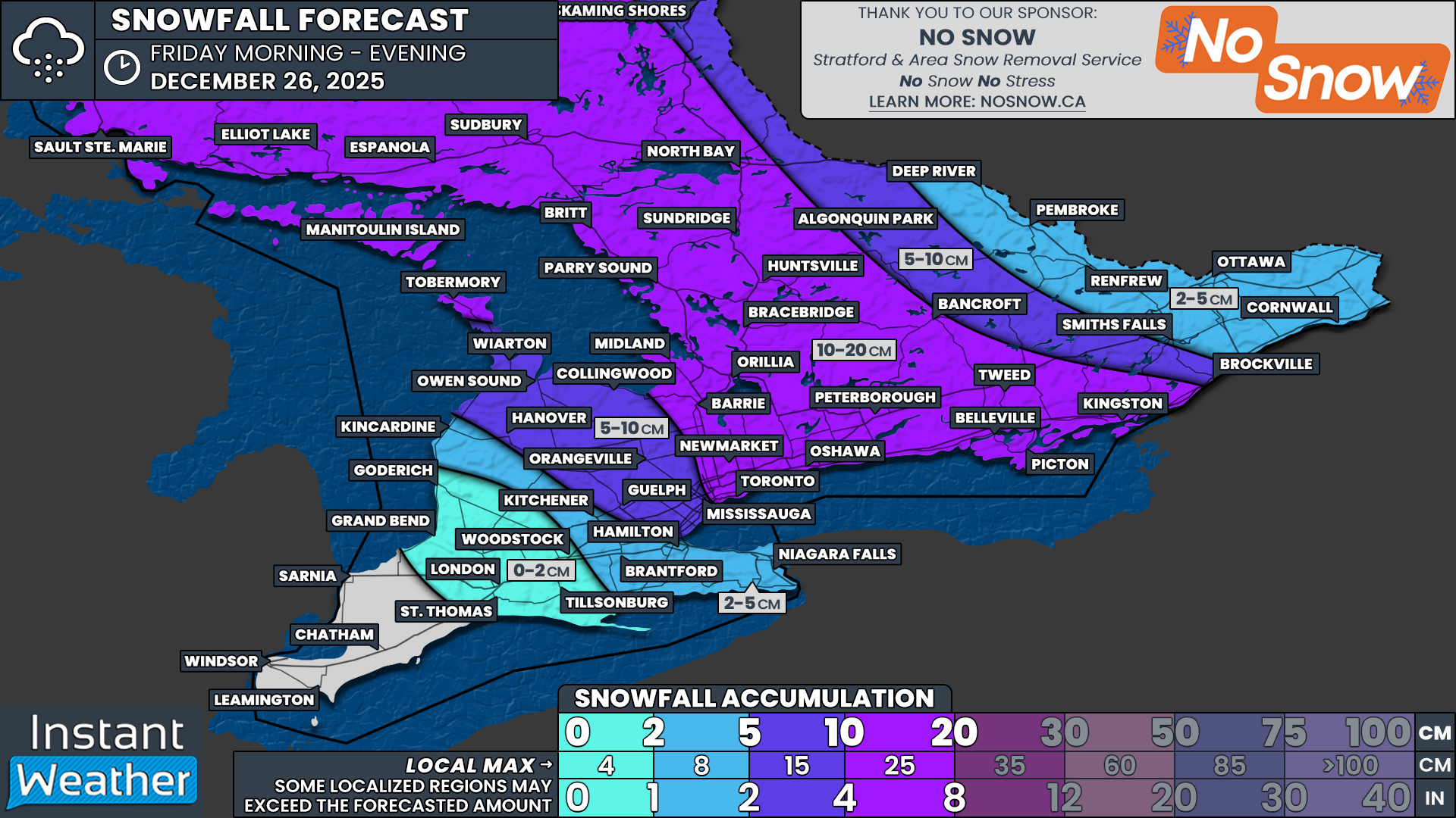
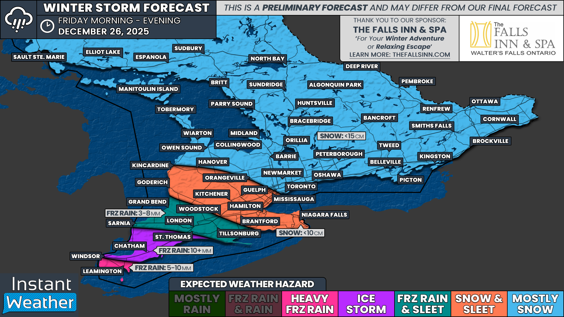
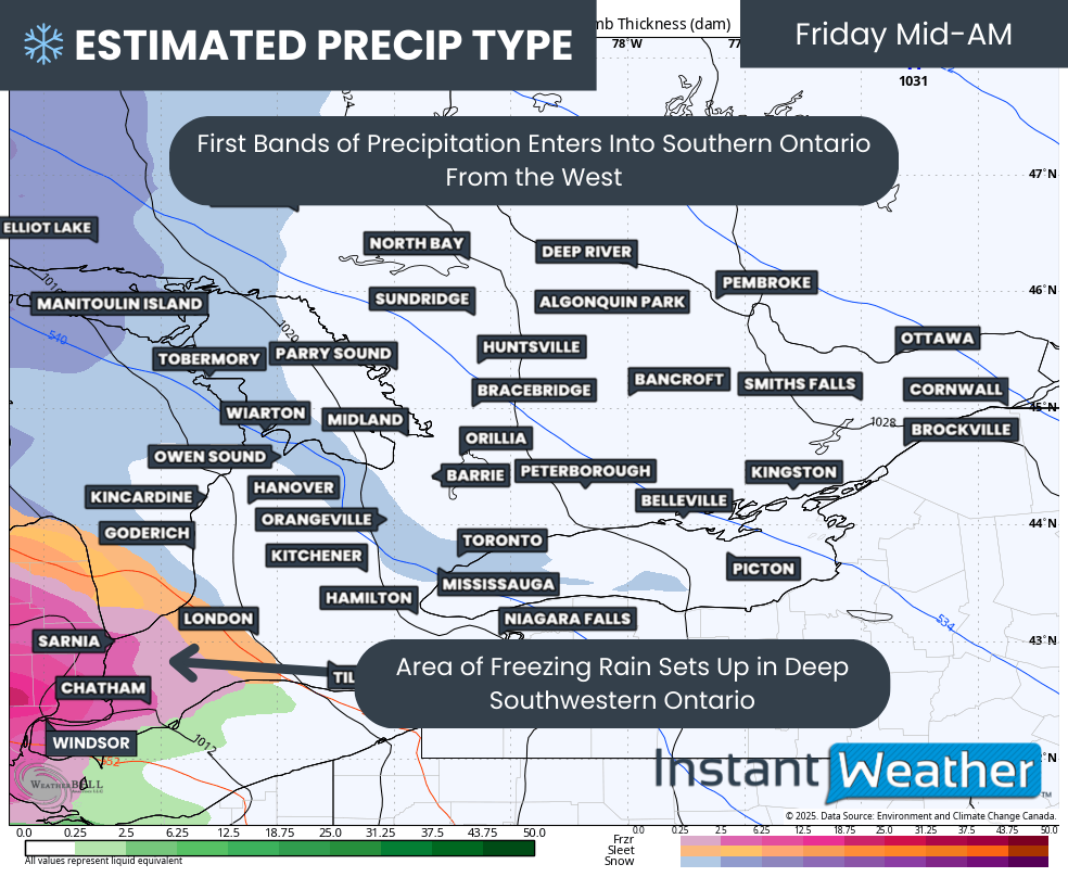
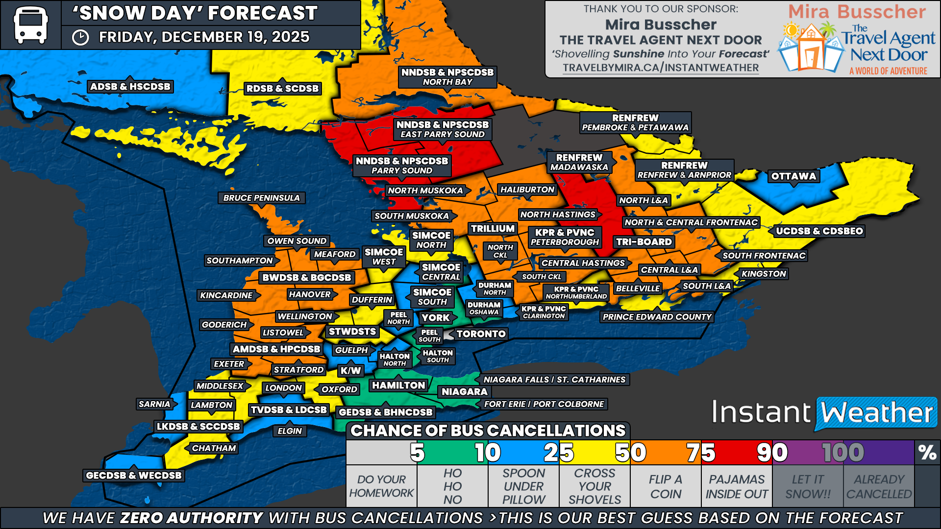
BREAKING: Major Winter Storm Expected for Ontario Beginning Sunday with Blizzard Conditions, Up to 50cm of Snow, 70-100km/h Winds, Flash Freezing, and 10-20mm of Freezing Rain
/
ZOOMED VERSION OF MONDAY FORECAST TO SHOW MORE LOCATIONS IN SOUTHERN ONTARIO - NOTE: CLICK OR TAP THE IMAGE TO OPEN AN IMAGE YOU CAN ZOOM
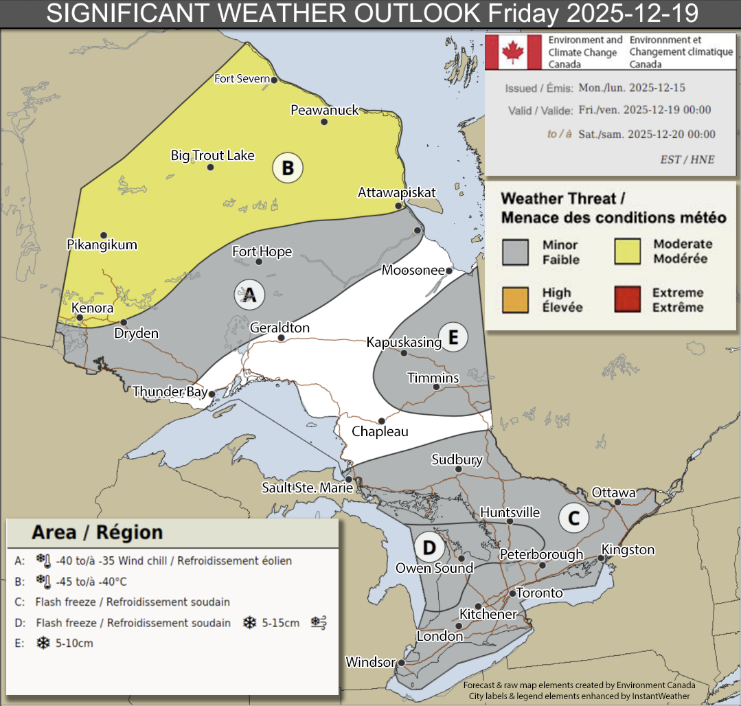
Environment Canada has upgraded their forecast map for this major winter storm expected to affect Ontario late Sunday through Monday. In their forecast, they’re mentioning a high risk for blizzard conditions, 70-100km/h wind gusts, 15-50cm of snow, intense snow squalls, 10-20mm of freezing rain and a flash freeze for parts of northeastern and southern Ontario.
NOTE: CLICK OR TAP THE IMAGE TO OPEN AN IMAGE YOU CAN ZOOM
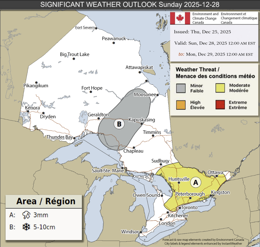
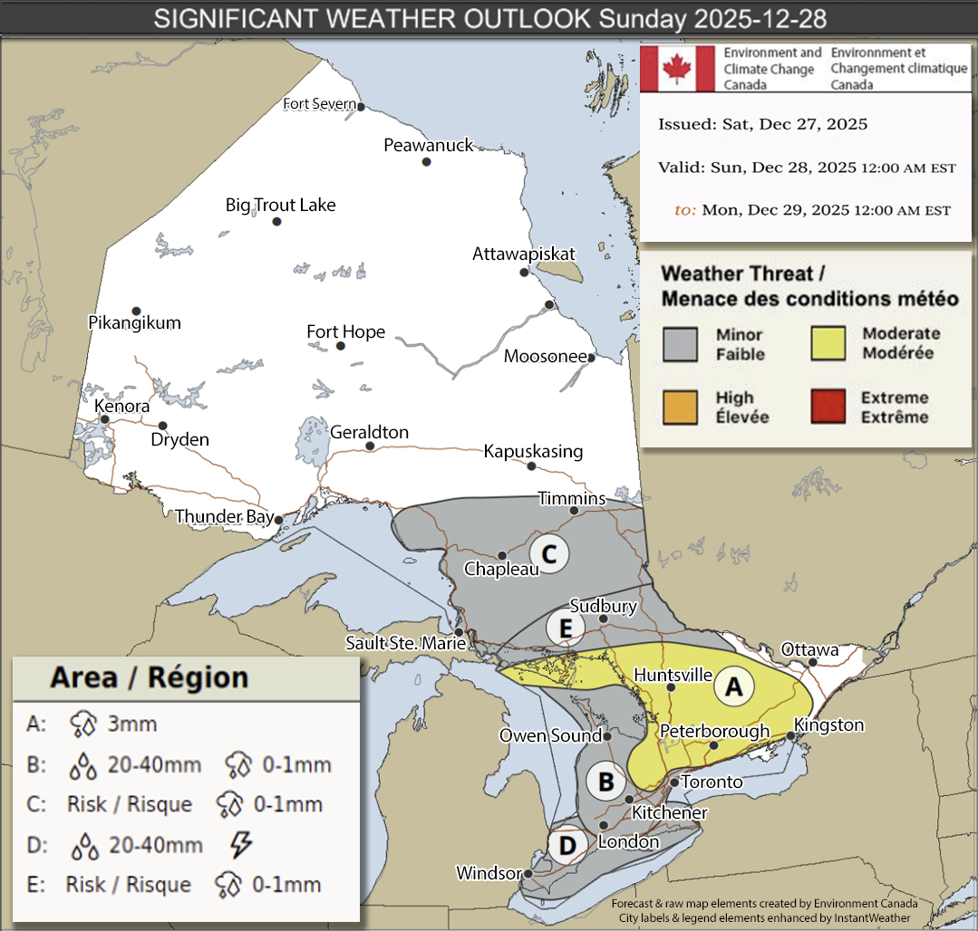
Sunday, December 28th:
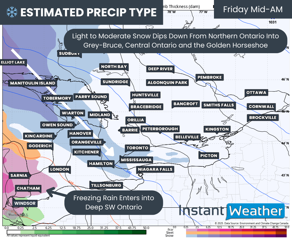
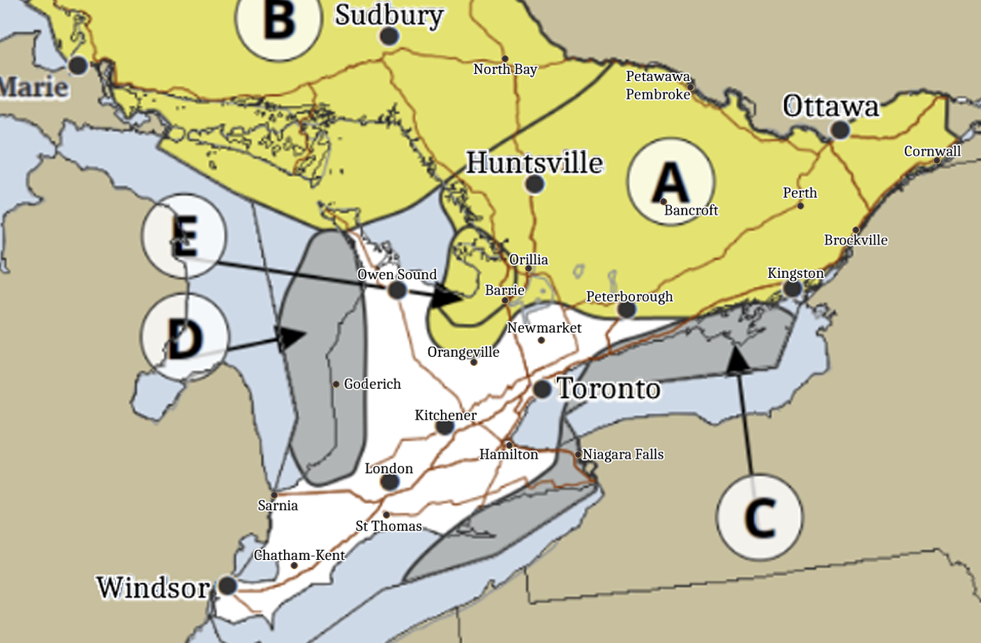
The storm begins on Sunday for many and really begins to ramp up Sunday evening and overnight. Below is Environment Canada’s location specific details:
”Location A: Portions of northeastern, eastern and central Ontario. Parts of the Greater Golden Horseshoe.
Hazard(s): Ice
Timing: Afternoon and evening into Monday.
Impact(s): Icy surfaces such as roads and walkways.
Impact level: High (3/4)
Confidence level: Moderate (2/4)
A long-duration freezing rain event is expected to begin in the afternoon, and evening for eastern Ontario. The event remains uncertain in terms of the areas that will receive the highest amount of freezing rain. Confidence is highest over areas of higher terrain and central Ontario.
———
Location B: Parts of southwestern Ontario and the Golden Horseshoe.
Hazard(s): Ice, Rain
Timing: Afternoon through evening.
Impact(s): Possible difficult travel conditions. Flooding in low-lying areas including roads.
Impact level: Low (1/4)
Confidence level: Moderate (2/4)
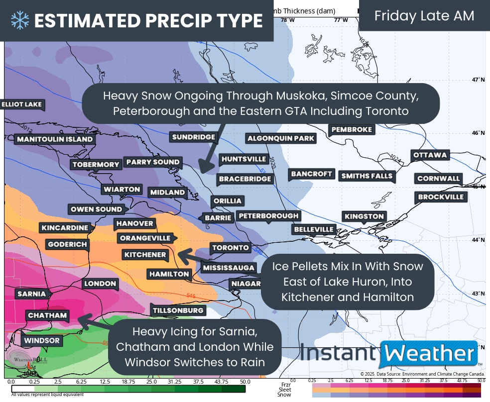
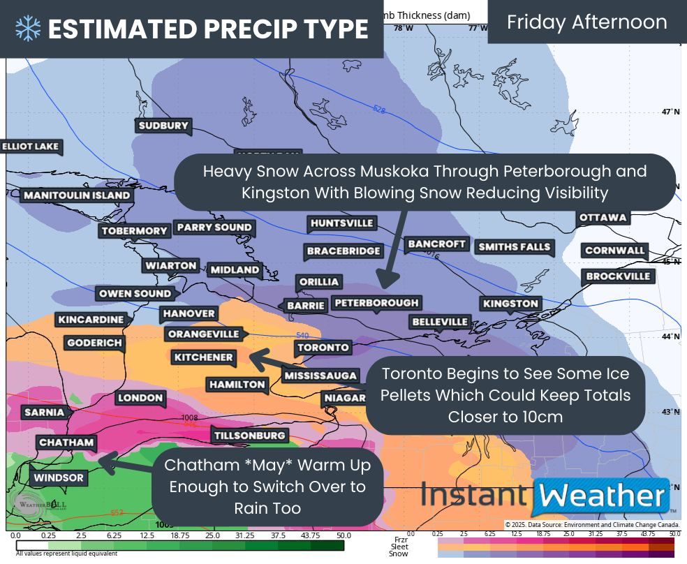
Freezing rain is possible with the approach of a low pressure system. Freezing rain is expected to be brief for most areas before a transition to rain, where up to 40 mm is possible through Monday morning.
———
Location C: Parts of northeastern Ontario.
Hazard(s): Ice
Timing: Early morning.
Impact(s): Possible difficult travel conditions.
Impact level: Moderate (2/4)
Confidence level: Low (1/4)
Patchy areas of freezing rain and ice pellets are possible.
———
Location D: Parts of southwestern Ontario and the Niagara Peninsula.
Hazard(s): Rain, Thunderstorm
Timing: Morning through Monday.
Impact(s): Flash flooding and water pooling on roads.
Impact level: Low (1/4)
Confidence level: Moderate (2/4)
Rainfall ahead of a low pressure system could bring amounts of 20 to 40 mm. Thunderstorms are also possible in the evening into Monday morning. Locally higher rainfall totals up to 50 mm are possible under heavier showers or thunderstorms.
———
Location E: Parts of northeastern Ontario.
Hazard(s): Ice
Timing: Late afternoon or evening into Monday.
Impact(s): Possible difficult travel conditions.
Impact level: Moderate (2/4)
Confidence level: Low (1/4)
Freezing rain is possible with the approach of a low pressure system. Ice pellets are likely to mix in as well.”

ZOOMED VERSION OF SUNDAY FORECAST TO SHOW MORE LOCATIONS IN SOUTHERN ONTARIO - NOTE: CLICK OR TAP THE IMAGE TO OPEN AN IMAGE YOU CAN ZOOM
NOTE: CLICK OR TAP THE IMAGE TO OPEN AN IMAGE YOU CAN ZOOM
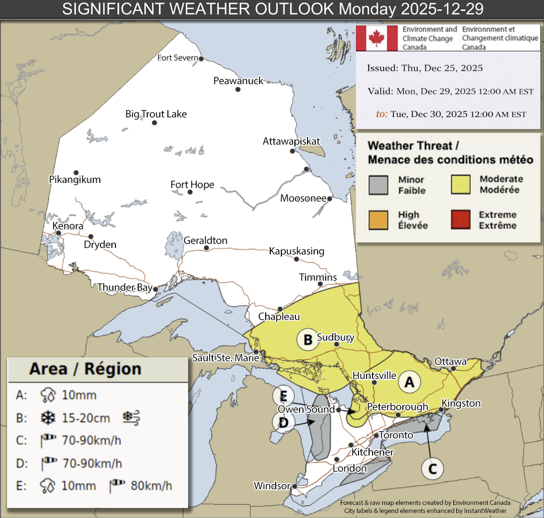
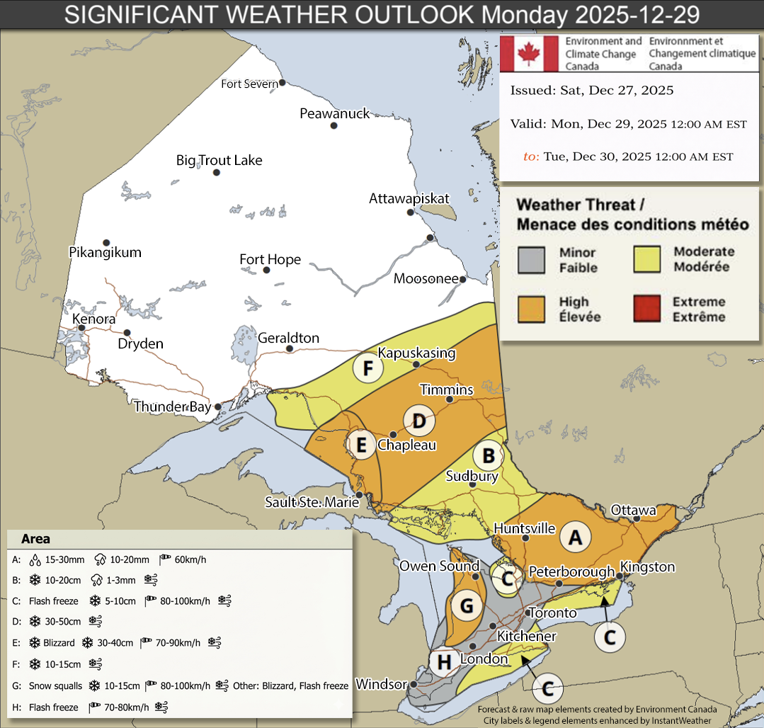
Monday, December 29th:
Here’s Environment Canada’s details for Monday:
”Location A: Eastern and central Ontario.
Hazard(s): Ice, Rain, Wind
Timing: Ending in the morning or early afternoon.
Impact(s): Icy surfaces such as roads and walkways. Broken tree branches from ice build-up. Utility outages.
Impact level: High (3/4)
Confidence level: High (3/4)
A strong and deep low will track across the area. A significant, prolonged freezing rain event is expected to continue into the morning or early afternoon. Lesser ice accretion is expected for areas just east of Georgian Bay and north of Lake Ontario. Wind gusts up to 60 km/h in the wake of the system may be impactful to areas with ice build-up. After temperatures rise above zero, up to 20 mm of rain is also possible.
———
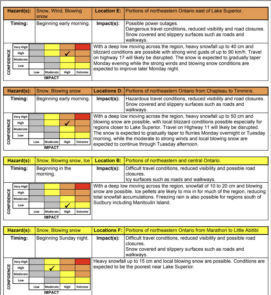
Location B: Portions of northeastern and central Ontario.
Hazard(s): Snow, Blowing snow, Ice
Timing: Beginning in the morning.
Impact(s): Difficult travel conditions, reduced visibility and possible road closures. Icy surfaces such as roads and walkways.
Impact level: High (3/4)
Confidence level: Low (1/4)
With a deep low moving across the region, snowfall of 10 to 20 cm and blowing snow are possible. Ice pellets are likely to mix in for much of the region, reducing total snowfall accumulations. Freezing rain is also possible for regions south of Sudbury including Manitoulin Island.
———
Locations C: Southeast of Georgian Bay, and northeastern shores of Lake Ontario and Lake Erie.
Hazard(s): Wind, Blowing snow, Snow, Ice
Timing: Beginning in the morning.
Impact(s): Loose objects may be tossed. Possible power outages. Difficult travel conditions, reduced visibility and possible road closures.
Impact level: Moderate (2/4)
Confidence level: High (3/4)
Strong westerly or northwesterly wind gusts of up to 100 km/h are possible in the wake of the strong low pressure system. Brief bands of heavy snow and local blowing snow are likely to accompany the strong winds by Monday afternoon. Snow squalls are expected to develop off of Georgian Bay in the evening and continue through Tuesday. Icy surfaces are also possible with temperatures quickly falling to below zero in the morning.
———
Locations D: Portions of northeastern Ontario from Chapleau to Timmins.
Hazard(s): Snow, Blowing snow
Timing: Beginning early morning.
Impact(s): Hazardous travel conditions, reduced visibility and road closures. Snow covered and slippery surfaces such as roads and walkways.
Impact level: High (3/4)
Confidence level: High (3/4)
With a deep low moving across the region, heavy snowfall up to 50 cm and blowing snow are possible, with local blizzard conditions possible especially for regions closer to Lake Superior. Travel on Highway 11 will likely be disrupted. The snow is expected to gradually taper to flurries Monday overnight or Tuesday morning, while the moderate to strong winds and local blowing snow are expected to continue through Tuesday afternoon.
———
Location E: Portions of northeastern Ontario east of Lake Superior.
Hazard(s): Snow, Wind, Blowing snow
Timing: Beginning early morning.
Impact(s): Possible power outages. Dangerous travel conditions, reduced visibility and road closures. Snow covered and slippery surfaces such as roads and walkways.
Impact level: High (3/4)
Confidence level: High (3/4)
With a deep low moving across the region, heavy snowfall up to 40 cm and blizzard conditions are possible with strong wind gusts of up to 90 km/h. Travel on highway 17 will likely be disrupted. The snow is expected to gradually taper Monday evening while the strong winds and blowing snow conditions are expected to improve later Monday night.
———
Locations F: Portions of northeastern Ontario from Marathon to Little Abitibi
Hazard(s): Snow, Blowing snow
Timing: Beginning Sunday night.
Impact(s): Difficult travel conditions, reduced visibility and possible road closures. Snow covered and slippery surfaces such as roads and walkways.
Impact level: Moderate (2/4)
Confidence level: High (3/4)
Heavy snowfall up to 15 cm and local blowing snow are possible. Conditions are expected to be the poorest near Lake Superior.
———
Location G: Southeast of Lake Huron.
Hazard(s): Wind, Blowing snow, Snow, Ice
Timing: Beginning in the morning.
Impact(s): Dangerous travel conditions, reduced visibility and road closures. Possible power outages. Icy surfaces such as roads and walkways.
Impact level: Extreme (4/4)
Confidence level: High (3/4)
Blizzard conditions in snow squalls are possible with strong wind gusts of up to 100 km/h in the wake of the strong low pressure system. Near zero visibility and bursts of heavy snow are likely especially in the afternoon. Icy surfaces are also possible with temperatures quickly falling to below zero early in the morning.
———
Location H: Portions of southwestern and central Ontario, as well as the Golden Horseshoe.
Hazard(s): Ice, Wind, Blowing snow
Timing: Beginning in the morning.
Impact(s): Loose objects may be tossed. Possible reduced visibility. Icy surfaces such as roads and walkways.
Impact level: Moderate (2/4)
Confidence level: Moderate (2/4)
Icy surfaces are possible with temperatures quickly falling to below zero in the morning. Strong wind gusts up to 70 km/h are possible through the day. Local blowing snow may accompany these wind gusts, especially over southwestern Ontario.”
NOTE: CLICK OR TAP THE IMAGE TO OPEN AN IMAGE YOU CAN ZOOM
NOTE: CLICK OR TAP THE IMAGE TO OPEN AN IMAGE YOU CAN ZOOM

ZOOMED VERSION OF MONDAY FORECAST TO SHOW MORE LOCATIONS IN SOUTHERN ONTARIO - NOTE: CLICK OR TAP THE IMAGE TO OPEN AN IMAGE YOU CAN ZOOM
NOTE: CLICK OR TAP THE IMAGE TO OPEN AN IMAGE YOU CAN ZOOM
Tuesday, December 30th:

ENVIRONMENT CANADA’s FORECAST MAP FOR TUESDAY, DECEMBER 30th, 2025 - NOTE: CLICK OR TAP THE IMAGE TO OPEN AN IMAGE YOU CAN ZOOM
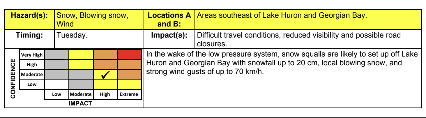
And, of course, no winter storm would be complete without snow squalls the next day. Environment Canada expecting snow squalls for London, Goderich, Barrie, Newmarket, Collingwood, Wasaga Beach, Stayner, Angus and surrounding communities on Tuesday. 10-20cm possible with gusty winds creating blowing snow and possible whiteouts. Specifically in the squalls east of Lake Huron, 70km/h wind gusts are possible as per Environment Canada:
”Locations A and B: Areas southeast of Lake Huron and Georgian Bay.
Hazard(s): Snow, Blowing snow, Wind.
Timing: Tuesday.
Impact(s): Difficult travel conditions, reduced visibility and possible road closures.
Impact level: High (3/4)
Confidence level: Moderate (2/4)
In the wake of the low pressure system, snow squalls are likely to set up off Lake Huron and Georgian Bay with snowfall up to 20 cm, local blowing snow, and strong wind gusts of up to 70 km/h.”
NOTE: CLICK OR TAP THE IMAGE TO OPEN AN IMAGE YOU CAN ZOOM
In summary:
It’s looking likely at this point that Sunday into Monday will be a major winter storm with significant impacts to travel, power outages, icy conditions, significant snowfall, whiteouts, and intense, potentially damaging wind gusts. If you don’t have to travel during this storm, that would be best. However, if it’s an emergency or you’re on the front lines, please give yourself as much time as possible. More details ASAP.