Wintry Mix of Snow, Sleet and Freezing Rain Threatens Thursday Morning Commute Across Southern Ontario

NOTE: YOU CAN CLICK ON THE MAP TO OPEN A ZOOMABLE IMAGE

A shift in the weather pattern across Southern Ontario over the past few days has brought a noticeable retreat from the extreme cold, with temperatures returning to near-seasonal values. However, this shift has also placed the region on a more active storm track, a pattern we first experienced with Monday’s messy system.

The next round of unsettled weather was initially showing signs of a prolonged freezing rain event on Thursday. However, recent model trends indicate a significantly weaker system than previously expected. While this storm will still impact Southern Ontario, the main threat now appears to be light freezing rain and snow, particularly during the Thursday morning commute.

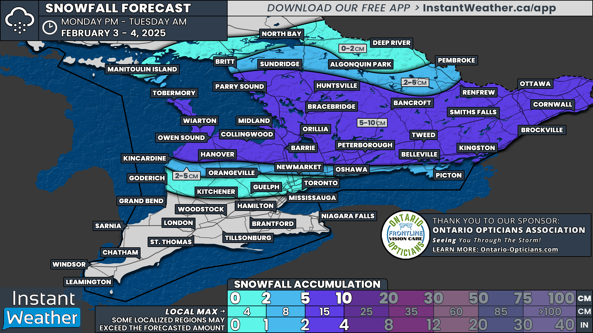
Although snowfall totals won’t be overly impressive, Central and Eastern Ontario could see an average accumulation of 4 to 8 cm by the end of the day. The primary concern will be the mix of precipitation types, which could create slushy and icy road conditions, making for a slick and potentially hazardous commute.

Looking ahead to the weekend, we are closely watching a moisture-laden system that could bring Southern Ontario its first true widespread snowstorm of the season. This storm has the potential to impact even those regions that have largely avoided significant snowfall so far, including Deep Southwestern Ontario and the Golden Horseshoe.

Current projections suggest snowfall totals could range from 10 to 25 cm, though these estimates will likely be refined as we get closer to the event.

PRECIPITATION TYPE OVER LAST 6 HOURS - MAP FROM WEATHERBELL

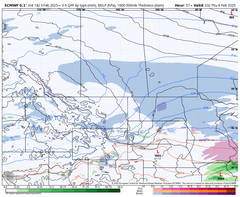
Thursday’s system is expected to begin during the morning hours as light precipitation moves in from the southwest. High-resolution models, such as the American model shown above, suggest that the precipitation will be quite scattered with dry pockets throughout. However, if the precipitation takes the form of light flurries or drizzle, some models may be underestimating its extent.

For Central and Eastern Ontario, precipitation will likely fall as snow. Across the Golden Horseshoe, it may also start as snow during the mid-morning hours before transitioning. Meanwhile, areas along the Lake Erie shoreline and Deep Southwestern Ontario will be more prone to freezing rain and ice pellets from the onset.

Travel conditions could become challenging, particularly in the morning as freezing rain coincides with rush hour across Southwestern Ontario and into the Golden Horseshoe.

At this point, it’s uncertain whether this system will be strong enough to prompt widespread school bus cancellations. However, the highest risk for disruptions will be in Windsor, Chatham, and London, where precipitation is expected to begin earlier in the morning with a higher likelihood of freezing rain.

PRECIPITATION TYPE OVER LAST 6 HOURS - MAP FROM WEATHERBELL

By early afternoon, precipitation should become more widespread, particularly in Central and Eastern Ontario, as drier areas fill in with moisture. Despite this, snowfall rates are expected to remain manageable, likely staying under 1 cm per hour. However, snow could persist for a solid 6 to 8 hours through the late morning and afternoon, leading to gradual accumulation.

Meanwhile, the freezing rain threat will begin expanding toward Hamilton and the western GTA, with ice pellets potentially mixing in as the transition from snow to freezing rain occurs.

Gradually, precipitation will taper off in Deep Southwestern Ontario, with lingering drizzle as temperatures slowly rise above freezing. This slight warm-up will help melt any ice accretion from earlier in the day.

Across the rest of Southern Ontario, precipitation should wind down by late afternoon or early evening. In the wake of the system, some minor lake-effect snow may develop around Georgian Bay and Lake Huron, but we are not expecting any organized lake-effect activity at this time.

PRECIPITATION TYPE OVER LAST 6 HOURS - MAP FROM WEATHERBELL

While Thursday’s system may be relatively minor, it could serve as a precursor to a much more impactful storm set to arrive this weekend.

Uncertainties remain, and details could shift as we get closer to Saturday. However, all major weather models continue to signal a strong system targeting Southern Ontario late Saturday into Sunday.

The exact track and intensity will determine which areas see the most significant impacts. At this point, current projections suggest a prolonged freezing rain threat for Deep Southwestern Ontario and areas along the Lake Erie shoreline. Meanwhile, heavy snow, with potential accumulations between 10 and 25 cm, could affect parts of the Golden Horseshoe, Central Ontario, and Eastern Ontario.

Again, this forecast is subject to change, but this storm has the potential to be a high-impact event for much of Southern Ontario. Stay tuned, as we’ll be providing more detailed updates in the coming days!

Bitter Arctic Air and Southern Moisture Will Bring up to 30cm of Snow to the Southern Prairies This Week

NOTE: YOU CAN CLICK ON THE MAP TO OPEN A ZOOMABLE IMAGE

The pattern of active weather across the Prairies will continue throughout the week with a new system moving in from the United States starting late Monday and continuing until Thursday afternoon.

Arctic air flooded southward following the passage of the storm this past weekend and it will have a significant impact on our incoming system. Very cold temperatures result in much higher snow ratios so what may look like a small amount of moisture actually leads to much greater accumulations of dry snow.

This is the situation we will find ourselves in this week. The incoming system doesn’t contain a great deal of moisture, but the cold temperatures, into the -20°s, will cause a significant amount of lightweight, dry snow to fall. Overall, we’re looking at a possibility of a widespread 20-30cm of snow falling across all three Prairie provinces.

The snow will fall mostly at a fairly light rate, however, the winds are expected to pick up overnight Wednesday in Saskatchewan and spreading into Manitoba through Thursday morning. The winds should peak early Thursday afternoon in Central and Southern Manitoba, gusting at up to 50km/h, before dying down in the evening so there could be a brief period of reduced visibility due to blowing snow.

Model Image showing the total amount of precipitation in millimetres

Alberta

Patches of snow will move into Southern Alberta and Southwest Saskatchewan late Monday night from North Dakota. It will spread northward throughout the morning, reaching the Edmonton area around the lunch hour Tuesday.

Later Tuesday afternoon, the snow in Central Alberta and parts of Southern Alberta will taper off, but it will gradually return throughout Wednesday morning as the system reorganizes and the snow becomes steadier. The snowfall across the southern half of the province will continue into early Wednesday afternoon, at which point it will start to dissipate from west to east and finally ending Thursday morning before sunrise.

Model Image showing the location and intensity of snowfall at 5AM MT/6AM CT Wednesday

Saskatchewan

After moving into Southwest Saskatchewan late Monday night, the patchy snow will spread northward and eastward throughout Tuesday morning and into the early afternoon. At that point, it should reach Lloydminster, as well as into the Saskatoon and Regina areas, but not quite to the Manitoba border.

Similar to what is expected to occur in Alberta, the snow along the leading edge is anticipated to dissipate beginning in the mid-afternoon Tuesday and continuing into the early evening before surging back across the province later in the evening. The reorganized snowfall will be much steadier overnight and through to Wednesday afternoon, possibly becoming heavy at times closer to the American border.

The snow will the begin to taper off in the Southwest early Wednesday afternoon as the system travels eastward, ending in Southern Saskatchewan in the late evening. Steady snow is expected to continue across parts of Central Saskatchewan during this period and will eventually start to dissipate through the pre-dawn hours of Thursday.

Model Image showing the location and intensity of snowfall at 8PM MT/9PM CT Wednesday

Manitoba

Snow will move into the Parkland Region from Saskatchewan early Wednesday morning and cross the width of the province thorough the morning and into the early afternoon. At that point, the snow will begin in the Westman region and spread across Southern Manitoba through the remainder of the afternoon and into the evening.

The snow in Southern Manitoba isn’t expected to last too long, with it dissipating from west to east starting in the late evening until the pre-dawn hours Thursday. Like Saskatchewan, the snow will persist across parts of Central Manitoba in the meantime, until early Thursday morning when it starts to taper off. The snow will finally end in Manitoba by noon on Thursday.

Southern Ontario: School Bus Cancellations for Monday, February 3, 2025

**Please refresh your page every few minutes to receive the latest update**

Cancellation & Closure Map (English Public and Catholic Schools)

Please note: School board boundaries are a rough estimate. Don’t use this map to determine what school board or weather zone you live in as accuracy isn’t guaranteed.

  • Green = No Cancellations

  • Red = Cancellations (Click for More Details)

  • Purple = School Closures (Click for More Details)

List of Cancellations & Closures

English Public and Catholic Schools

  • Lambton Kent Public & St. CIair Catholic: Buses in Zones 5, 6 & 7 Cancelled due to Fog.

  • Near North Public & Nipissing-Parry Sound CathoIic: Busses are cancelled in the following regions: West Parry Sound ( Britt/Nobel - Mcdougall/Whitestone/Ahmic Harbour - Town of Parry Sound - Mactier/Humphrey/Rosseau); East Parry Sound South ( South of and excluding Hwy 522 - South River/Sundridge/Burk's Falls/Magnetawan/Katrine/Emsdale/Novar/Sprucedale)

  • Thames Valley Public & London CathoIic: School purpose vehicles in the WEST ELGIN area are CANCELLED for the MORNING ONLY due to fog.

French Schools

  • Conseil scolaire Viamonde & Conseil scolaire catholique Providence: Buses in Zones 5, 6 & 7 Cancelled due to Fog.

  • Le Conseil scolaire public du Nord-Est de l’Ontario (CSPNE) & Conseil scolaire catholique Franco-Nord: Busses are cancelled in the following regions: West Parry Sound ( Britt/Nobel - Mcdougall/Whitestone/Ahmic Harbour - Town of Parry Sound - Mactier/Humphrey/Rosseau); East Parry Sound South ( South of and excluding Hwy 522 - South River/Sundridge/Burk's Falls/Magnetawan/Katrine/Emsdale/Novar/Sprucedale)

Willie Is Wrong! February Roars Into Southern Ontario With Up to 10cm of Snow for Central & Eastern Ontario on Monday

NOTE: YOU CAN CLICK ON THE MAP TO OPEN A ZOOMABLE IMAGE

Wiarton Willie emerged from his burrow on Sunday morning and didn’t see his shadow, predicting an early spring. But as Southern Ontario residents wake up to an active weather pattern, it looks like Mother Nature may have other plans.

A stormy week is ahead, with multiple systems taking aim at the region. The first arrives Monday, bringing a messy mix of heavy snow, freezing rain, and rain. Central and Eastern Ontario will bear the brunt of the snowfall, while areas northwest of the GTA could see prolonged freezing rain.

The most significant concern, however, is a potentially high-impact storm on Thursday. Current model data points to a prolonged freezing rain event for Southwestern Ontario and the Golden Horseshoe, though the exact track remains uncertain. A slight shift north or south could change precipitation types and affected areas.

PRECIPITATION TYPE - MAP FROM WEATHERBELL

The first storm system of the week will begin affecting Southern Ontario late Monday morning. Light to moderate snow will spread into Grey-Bruce, Muskoka, Parry Sound, and areas east of Georgian Bay.

At the same time, a light freezing drizzle could develop across parts of the GTA, Kitchener, and London, though it should remain fairly light and not overly impactful. Still, untreated roads and sidewalks could become slick.

PRECIPITATION TYPE - MAP FROM WEATHERBELL

By early to mid-afternoon, the storm will intensify, with moderate to heavy snow spreading into Central and Eastern Ontario, including Ottawa, Peterborough, and Barrie.

At the same time, freezing rain may become prolonged in a narrow corridor northwest of the GTA, affecting Shelburne, Orangeville, and northern York Region.

Further south, rain will dominate along the Lake Ontario shoreline and into Southwestern Ontario.

PRECIPITATION TYPE - MAP FROM WEATHERBELL

As Monday evening approaches, the storm will begin to taper off from west to east. Snow will transition to flurries in Southwestern Ontario around dinnertime, while Central and Eastern Ontario will see precipitation continue into the evening before ending around midnight.

However, freezing rain may linger longer in higher elevations northwest of the GTA, potentially impacting Guelph and Kitchener.

NOTE: YOU CAN CLICK ON THE MAP TO OPEN A ZOOMABLE IMAGE

While this storm won’t produce extreme snowfall rates, widespread accumulation is expected across Central and Eastern Ontario. Most areas from Grey-Bruce through Muskoka, Simcoe County, Peterborough, Kingston, Ottawa, and Cornwall will see 5 to 10 cm of snow.

Localized areas near Georgian Bay could exceed expectations, as lake enhancement may fuel pockets of heavier snow, pushing some totals closer to 15 cm. However, confidence remains low in this scenario, so no forecast upgrades have been made to the 10-20 cm range.

South of these regions, snowfall amounts will drop quickly as precipitation transitions to freezing rain and rain. The northern GTA and Durham Region could see 2-5 cm of accumulation, with icing concerns in a narrow corridor stretching from Kincardine through Orangeville, Newmarket, Oshawa, Belleville, and Kingston.

NOTE: YOU CAN CLICK ON THE MAP TO OPEN A ZOOMABLE IMAGE

Freezing rain could be persistent, with most areas seeing around 2 mm of ice accretion.

However, in higher elevations like the Dundalk Highlands, up to 4 mm of ice could accumulate, increasing the risk of localized slick conditions.

PRECIPITATION TYPE - MAP FROM WEATHERBELL

As Monday’s system moves out, attention turns to a more significant storm later in the week.

A major winter storm is possible on Thursday, with global weather models consistently highlighting the risk of prolonged freezing rain. Right now, Southwestern Ontario and the Golden Horseshoe appear to be in the bullseye. However, the storm’s track remains uncertain, and even a small shift north or south could drastically alter the precipitation types and affected areas.

  • A more southerly track would favour a snowstorm for Southern Ontario.

  • A more northerly track would put Central and Eastern Ontario at risk for significant icing.

Regardless of the final path, Thursday’s storm could bring major disruptions, particularly to the morning commute. Widespread school bus cancellations appear likely based on current data, though details may change as the system evolves.

Stay tuned for updates as we track these storms!

Multi-Day Snowfall & Freezing Rain Event Targets Ontario This Week Says Environment Canada

NOTE: YOU CAN CLICK ON THE MAP TO OPEN A ZOOMABLE IMAGE

A complex and potentially high-impact winter storm is set to affect portions of Ontario this week, bringing a mix of snow, freezing rain, and difficult travel conditions over several days. While there is still some uncertainty regarding the exact track and intensity of this system, below are the details from Environment Canada’s latest forecast.


Monday: Snow & Freezing Rain for Central & Eastern Ontario

A low-pressure system tracking across Ontario will bring up to 10 cm of snowfall to parts of central and eastern Ontario on Monday. In the afternoon, there is also a risk of freezing rain or freezing drizzle, which could make roadways slick and hazardous.

NOTE: YOU CAN CLICK ON THE MAP TO OPEN A ZOOMABLE IMAGE

  • Hazard: Snow and possible freezing rain

  • Location: Central and eastern Ontario

  • Timing: Monday

  • Confidence Level: Moderate

  • Potential Impacts: Slippery roads and difficult travel conditions

NOTE: YOU CAN CLICK ON THE DISCUSSION TO OPEN A ZOOMABLE IMAGE

While this system is not expected to be particularly severe, even a light glaze of ice on top of fresh snowfall can make for treacherous road conditions. Drivers should allow extra time for travel and be prepared for rapidly changing weather conditions.


Wednesday Evening: Freezing Rain Targets Southwestern Ontario

By midweek, another low-pressure system is expected to track across southern Ontario, bringing the potential for freezing rain across portions of southwestern Ontario. Ice accumulations of 5 to 10 mm could occur, significantly increasing the risk of hazardous road conditions.

NOTE: YOU CAN CLICK ON THE MAP TO OPEN A ZOOMABLE IMAGE

  • Hazard: Freezing rain

  • Location: Southwestern Ontario

  • Timing: Wednesday evening

  • Confidence Level: Low (track and timing uncertain)

  • Potential Impacts: Significant impacts on rush hour traffic and difficult travel conditions

NOTE: YOU CAN CLICK ON THE DISCUSSION TO OPEN A ZOOMABLE IMAGE

At this point, uncertainty remains high regarding the exact location and duration of the freezing rain event. However, if ice accumulation reaches the higher end of projections, travel disruptions and potential power outages could be a concern. Stay tuned for updates as more details become available.


Overnight Wednesday into Thursday: Freezing Rain for Southern Ontario

As the system continues moving east, freezing rain may expand into portions of southern Ontario overnight Wednesday and continue into Thursday afternoon. Ice accumulation of up to 5 mm is possible, leading to potentially treacherous conditions during the Thursday morning commute.

NOTE: YOU CAN CLICK ON THE MAP TO OPEN A ZOOMABLE IMAGE

  • Hazard: Freezing rain

  • Location: Southern Ontario

  • Timing: Wednesday overnight into Thursday afternoon

  • Confidence Level: Low (track and amounts still uncertain)

  • Potential Impacts: Significant travel disruptions during morning rush hour

NOTE: YOU CAN CLICK ON THE DISCUSSION TO OPEN A ZOOMABLE IMAGE

With temperatures hovering near the freezing mark, even a thin layer of ice could make roads extremely slippery. If the system strengthens, some areas could experience prolonged freezing rain, increasing the likelihood of ice buildup on roads, trees, and power lines.


Thursday: Snow & Ice for Northern Ontario

While southern Ontario deals with freezing rain, northern regions will likely see a combination of snow and ice on Thursday. Areas in eastern and northeastern Ontario could see up to 15 cm of snowfall, along with a risk of freezing rain.

NOTE: YOU CAN CLICK ON THE MAP TO OPEN A ZOOMABLE IMAGE

  • Hazard: Snow and freezing rain

  • Location: Portions of southern and northern Ontario

  • Timing: Thursday

  • Confidence Level: Low

  • Potential Impacts: Difficult travel conditions, slippery roads, and potential power outages

NOTE: YOU CAN CLICK ON THE DISCUSSION TO OPEN A ZOOMABLE IMAGE

As with earlier parts of this system, uncertainty remains about the exact track and timing, which will determine snowfall amounts and areas most affected by ice.


Final Thoughts: Stay Alert & Prepare for Winter Hazards

While there’s still uncertainty about exact details, this system has the potential to create dangerous travel conditions across multiple days. With the possibility of accumulating snow, freezing rain, and icy roads, anyone traveling this week should stay informed and plan ahead.

✔️ Check for updates – Weather forecasts will continue to shift and change as new data becomes available.
✔️ Prepare for icy conditions – If freezing rain materializes, roads could become extremely slick, and power outages may occur.
✔️ Allow extra time for travel – Winter storms can lead to slower commutes and dangerous driving conditions.

As always, we’ll be watching this system closely and providing updates as more details emerge. Stay safe and keep an eye on our free Instant Weather app for real-time notifications!


Disclaimer: These forecasts are issued by Environment Canada and typically published via their Twitter/X accounts. We receive these forecast via a daily email and often publish them for our communities to see. We also zoom them in and add more city & town names for more significant events to ensure our community can quickly determine where they are located on the map and what impacts may affect them.

Second Day of Snowfall Expected to Bring Widespread 10-20cm of Snow Across the Prairies on Saturday

NOTE: YOU CAN CLICK ON THE MAP TO OPEN A ZOOMABLE IMAGE

The first day of our multi-day snow event brought light to moderate snow to all three Prairies provinces by Friday evening. Snowfall totals for the entire event are still expected to top 30cm across a significant portion of the region, with Saturday’s snowfall bringing over 10cm of accumulation to many.

Before discussing what is expected on Saturday, we first need to determine the positioning of the system at approximately midnight. As seen in the model image below for that point in time, snow will still be falling across most of Northern Alberta and along the Rockies. It will also continue to extend southeastward across Saskatchewan and into Southwestern Manitoba.

Model Image showing the Location and Intensity of the Snowfall at 11Pm MT Friday/12AM CT Saturday

Alberta

The snow will continue across Northern Alberta and the Rockies through the early morning hours of Saturday as the entire system continues to travel eastward. There’s expected to be a break in the snowfall for a few hours from Grande Prairie to Cold Lake through the early morning, but that will be followed by a secondary wave of heavier snowfall trailing closely behind.

This additional area of snow will stretch southward into Central Alberta, bringing more snow to Edmonton and possibly even some light flurries across Southern Alberta throughout the day. The snow will cross this part of the province during the morning and afternoon and by the evening, the band of snow will be almost entirely in Saskatchewan. Snowfall totals for Central and Southern Alberta won’t be too high, with most receiving less than 5cm by the end of the day and the last of the snow they can expected from this event.

Later in the morning, we’ll start to see the snow tapering off in parts of Northern Alberta from west to east, bringing accumulation for this area to 5-10cm. The snow will continue to fall further north; in areas like Peace River, High Level, and Fort McMurray; straight into the overnight hours, bringing snowfall accumulations here up to 30cm by the end of the day.

As the snow clears behind the second wave of snow, Arctic air will flood southward and the temperatures will start to fall into the -20°s,

Model Image showing the Location and Intensity of the Snowfall at 5Am MT/6AM CT Saturday

Saskatchewan

The snow will gradually end in Southern Saskatchewan, from west to east, throughout the early morning hours as the system continues to travel eastward. The same can be said further north in the province, but beginning a couple hours later, closer to sunrise, due to the northwest to southeast orientation of the large band of snow.

The second wave of snow from Alberta will cross into Saskatchewan several hours later, in the mid-morning, which will add to the earlier snowfall across much of the province. Southwest Saskatchewan can expect little to no snow from this, but isolated flurries can’t be completely ruled out. Snowfall is, however, anticipated in the southeast corner of the province as it appears this secondary line will see some southward development as it crosses the province.

By the end of the day, a majority of Saskatchewan will have received at least 5cm of snow, with a significant portion over 10cm. Snow will still be falling across most of the province overnight and into Sunday morning, which will add to the total amount received from the event and will be covered in the next forecast.

Model Image showing the Location and Intensity of the Snowfall at 11Am MT/12M CT Saturday

Manitoba

The snowfall isolated to Southwestern Manitoba late Friday will spread eastward across the southern portions of the province through Saturday morning. Snow will also gradually begin to fall moving northward along the Saskatchewan border as the main band of snow continues along the same eastward trajectory.

This snow may be heavy at times, leading to quick accumulation. The lightest snow will be along the southern edge, which can expect less than 5cm total by the end of the day.

In the late morning, areas in the southwest will see the snow start to taper off as the initial band of snow exits the region. There will be several hours of calm before the second wave moves in during the evening. This wave will only make it about halfway across the province before midnight, so only a small area can expect over 10cm of snow total for Saturday.

Model Image showing the Location and Intensity of the Snowfall at 11Pm MT Saturday/12AM CT Sunday

Sunday

On Sunday, the entire system starts to exit the Prairies followed by temperatures in the -20°s and -30°s across the entire region. There will still be some decent snowfall across the region throughout the day, which we will cover in the forecast that will be posted Saturday evening.

Active Winter Weather Returns to the Prairies With Widespread Snowfall Exceeding 30cm Beginning Friday

NOTE: YOU CAN CLICK ON THE MAP TO OPEN A ZOOMABLE IMAGE

The month of January has been fairly quiet across the Prairies, with periods of frigid Arctic air and some occasional snowfall as well as much more mild temperatures in the past week. Now, to end the month, we’re bracing for the return of the Arctic air and the most impactful storm since November. This incoming system will bring over 30cm of snowfall to a large swath across all three Prairie provinces by late Monday.

Considering how long the snow is expected to fall across the region, we’ll be breaking the forecast down into daily segments.

Friday

The snow will make its way into Alberta in the Northern Rockies ahead of a warm front early Friday morning, a couple of hours after midnight, as a low-pressure system pushes eastward from British Columbia. Meanwhile, snow will also develop along the front further south, to the east of Calgary.

These two areas of snowfall will merge together after a few hours, before sunrise, as the front surges northeastward. At the same time, snow will continue to develop along the length of the front and start making its way into Southwest Saskatchewan.

Model Image showing the Location and Intensity of the Snowfall at 7pm MT/8PM CT

As the low-pressure center makes its way across Alberta Friday morning and afternoon, the large area of snowfall will expand further northward in Alberta and eastward across Saskatchewan. In the evening, the leading edge of the snow will start to cross into Southwestern Manitoba and the entire line of snow will continue to travel eastward as we move into the overnight hours.

The snow is expected to remain steady over an area that covers Grande Prairie and east to Lac La Biche from the late morning straight through to the end of the day, which will lead to this area receiving the greatest accumulation of 10-20cm for Friday. The snow along the length of the front is anticipated to remain fairly moderate, but it may end up being patchy, resulting in some areas seeing breaks in the snowfall. Despite this, a widespread 5-10cm is expected to fall across Alberta and Saskatchewan.

Saturday

The cold air will wrap around the backside of this storm and that will become noticeable starting in Alberta Saturday morning. The snow will continue in parts of all three Prairie provinces throughout the day Saturday and we’ll have more details of how much to expect in the forecast we will post tomorrow.

Thursday's Snowfall in Alberta Just a Precursor to a Larger Storm That Will Close Out January and Start February

NOTE: YOU CAN CLICK ON THE MAP TO OPEN A ZOOMABLE IMAGE

Enjoy the mild temperatures will they last, with the return of more winter-like conditions in Central and Southern Alberta expected to finish the month of January. Things will kick off with a band of snow crossing parts of Northern and Central Alberta on Thursday, followed by a much larger system that will impact a greater portion of Alberta and moving through the Prairies beginning Friday morning.

Light, patchy snow will begin later Wednedsay evening in the Grande Cache area and will slowly spread eastward towards Edmonton overnight and through Thursday morning and early afternoon. The snow will start to dissipate in the late afternoon from east to west, and likely spread a bit southward closer to the Rockies, before completely tapering off around midnight. This pattern will result in widespread 5-10cm, but greater snowfall accumulations, above 10cm, are expected in areas like Edson and Whitecourt and less than 5cm towards the Saskatchewan border.

To the north, in the Peace River region, an additional area of snow will develop in the pre-dawn hours Thursday and settle over the area until the mid-afternoon, leading to up to 10cm of accumulation before tapering off as well.

This brief snowfall event can be considered an appetizer to the main event that is set to begin early Friday morning and continue in Alberta until late Sunday or early Monday. A detailed forecast will be issued Thursday afternoon.

Southern Ontario: School Bus Cancellations for Wednesday, January 29, 2025

**Please refresh your page every few minutes to receive the latest update**

Cancellation & Closure Map (English Public and Catholic Schools)

Please note: School board boundaries are a rough estimate. Don’t use this map to determine what school board or weather zone you live in as accuracy isn’t guaranteed.

  • Green = No Cancellations

  • Red = Cancellations (Click for More Details)

  • Purple = School Closures (Click for More Details)

List of Cancellations & Closures

English Public and Catholic Schools

  • Avon MaitIand Public & Huron-Perth CathoIic: There are widespread bus cancellations and some school closures. Visit this link for more details: https://hpsts.mybusplanner.ca/Alerts

  • BIuewater Public & Bruce-Grey Catholic: There are widespread bus cancellations and school closures. Visit this link for more details: https://mybrucegreyschoolbus.ca/Cancellations.aspx

  • Dufferin-PeeI Catholic: Buses to St Andrew, St Peter, St Benedict, RF Hall and buses in STOPR Zone 3 are cancelled

  • Durham Public & Durham Catholic: Busses are cancelled in Zone 1 (Brock).

  • HaIton Public & Halton Catholic: Busses in Zone 3 (Halton Hills) are cancelled.

  • Kawartha Pine Ridge Public & Peterborough Victoria Northumberland Clarington Catholic: All busses are cancelled.

  • Near North Public & Nipissing-Parry Sound CathoIic: Buses are cancelled in the following regions: All busses for West Parry Sound (Britt/Nobel - Mcdougall/Whitestone/Ahmic Harbour - Town of Parry Sound - Mactier/Humphrey/Rosseau) are cancelled.

  • Ottawa CarIeton Public & Ottawa Catholic: All busses are cancelled.

  • Renfrew County Public & Renfrew County Catholic: All busses are cancelled.

  • Simcoe County Public & Simcoe Catholic: All busses are cancelled.

  • Tri-Board: All busses are cancelled.

  • Trillium Lakelands: All busses are cancelled.

  • Upper Canada Public & Eastern Ontario CathoIic: All busses are cancelled.

  • Upper Grand Public & Wellington CathoIic: Busses are cancelled in North Wellington (Division 3) and Dufferin County (Division 4). Schools in North Wellington and Dufferin County are closed.

  • WaterIoo Public & WaterIoo Catholic: Busses in Wellesley, Wilmot and Woolwich Townships are cancelled

French Schools

  • Conseil scolaire de district catholique Centre-Sud: There are several bus cancellations. Visit this link for details: https://www.cscmonavenir.ca/ecole/

  • Conseil scolaire de district catholique de l'Est Ontarien: All busses are cancelled.

  • Conseil des écoles catholiques de langue française du Centre-Est: Busses are cancelled in: Arnprior, Brockville, Carleton Place, Almonte, Renfrew County (schools in Pembroke), United Counties of Prescott-Russell, Kingston, Marionville, Merrickville and Kemptville, Ottawa, and Trenton.

  • Conseil scolaire Viamonde & Conseil scolaire catholique Providence: There are multiple cancellations. Please visit this link for details: https://infobus.francobus.ca/cancellations.aspx

Up to 20cm of Fresh Snow On Its Way For the Maritimes Wednesday and Thursday

NOTE: YOU CAN CLICK ON THE MAP TO OPEN A ZOOMABLE IMAGE

On the heels of some strong winds and a bit of snow Monday night and throughout the day Tuesday, it appears that snow and colder temperatures will close off the month of January for the Maritimes.

An incoming system will push into the region Wednesday morning, bringing snow to Western Nova Scotia and Southern New Brunswick shortly after sunrise. The snow will spread eastward through the morning and afternoon, reaching Cape Breton and PEI by the late afternoon.

This initial band of snow will be light to moderate, resulting in widespread amounts of roughly 5cm of snow across Nova Scotia and PEI as well as into Southern New Brunswick. Meanwhile, some scattered light snow is expected throughout the day across Central and Northern New Brunswick, which will also lead to up to 5cm of accumulation.

A second round of slightly heavier snowfall will move into Western Nova Scotia and Southern New Brunswick in the evening and make the commute home tricky, especially in the western half of the province. This snow will spread eastward through the remainder of the evening and overnight, leading to an additional 5-10cm of accumulation and up to 20cm overall.

The snow will taper off in the early morning hours, but there could be some flurries lingering throughout Thursday morning, especially in Eastern Nova Scotia and PEI. While not as windy as Monday night and Tuesday, wind gusts up to 50km/h are expected on Thursday which along with the cold air settling in, could drive windchill values closer to -25°C.

'Snow Day' Forecast: Alberta Clipper Likely to Cause Widespread School Bus Cancellations Across Southern Ontario on Wednesday

NOTE: YOU CAN CLICK ON THE MAP TO OPEN A ZOOMABLE IMAGE

Heavy snow is currently sweeping across Southern Ontario as an Alberta Clipper makes its way through the region. By Wednesday morning, this system is expected to deliver widespread snowfall totals of up to 15 cm across Eastern, Central, and Southwestern Ontario.

In addition to the snowfall from the system itself, lake effect snow will develop in the wake of the clipper, primarily around Lake Huron and Georgian Bay.

These squalls are expected to begin during the late morning and continue into Wednesday afternoon. Environment Canada has issued snow squall watches for these regions, which are likely to be upgraded to warnings by early Wednesday.

With heavy snow persisting overnight and the added impact of lake effect snow during the day, it is highly likely that school boards in affected areas will cancel school buses on Wednesday.

Most of the snow from the Alberta Clipper will fall Tuesday evening and taper off overnight for areas outside the snowbelt. However, rural regions may still struggle to clear backroads in time for the morning commute. This was evident on Tuesday when widespread cancellations occurred despite the snow ending hours before the morning bus runs.

Conditions on Wednesday are expected to be similar or even worse in some areas, particularly in Eastern Ontario, where snow will still be falling during the early morning hours.

The greatest likelihood of a "snow day" will be in rural school boards in Eastern Ontario, which are typically more cautious when it comes to heavy snow. Grey, Bruce, and Huron counties are also strong candidates for cancellations, as these areas are still digging out from previous snowfalls and are expected to see additional squalls on Wednesday.

For the rest of Central and Eastern Ontario, school bus cancellations remain uncertain. Decisions will largely depend on local road conditions and how efficiently crews can clear roads, especially critical backroads.

Urban areas like Ottawa and the Greater Toronto Area are not expected to experience enough snow to trigger bus cancellations. However, Ottawa has a slightly higher chance than Toronto due to ongoing snowfall during the early morning hours, which may make the roads more difficult to clear.

Here is a breakdown of the likelihood of school bus cancellations by region:

Almost Certain (90–99% Chance)

  • Avon Maitland District School Board (Goderich)

  • Bluewater District School Board (Kincardine & Southampton)

  • Tri-Board (North Hastings, North L&A & North Frontenac)

Likely (75–90% Chance)

  • Avon Maitland District School Board (Exeter, Stratford & Listowel)

  • Bluewater District School Board (Bruce Peninsula, Owen Sound, Meaford & Hanover)

  • Simcoe County District School Board (West Zone)

  • Kawartha Pine Ridge District School Board (Peterborough)

  • Trillium Lakelands District School Board (Haliburton)

  • Tri-Board (Centre Hastings, Central L&A & South Frontenac)

  • Renfrew County District School Board (Madawaska)

  • Upper Canada District School Board

Possible (50–75% Chance)

  • STWDSTS (Wellington & Dufferin)

  • Simcoe County District School Board (Central & North Zone)

  • Trillium Lakelands District School Board (Muskoka & CKL)

  • Near North District School Board (Town of Parry Sound)

  • Kawartha Pine Ridge District School Board (Northumberland)

  • Tri-Board (Belleville, Prince Edward County, South L&A & Kingston)

  • Renfrew County District School Board (Renfrew & Pembroke)

Maybe (25–50% Chance)

  • Thames Valley District School Board (Middlesex & Oxford)

  • Waterloo Region District School Board

  • Simcoe County District School Board (South Zone)

  • Near North District School Board (East Parry Sound)

  • Kawartha Pine Ridge District School Board (Clarington)

  • Ottawa-Carleton District School Board

Unlikely (10–25% Chance)

  • Thames Valley District School Board (London & Elgin)

  • Halton District School Board (North)

  • Peel District School Board (North)

  • York Region District School Board

  • Durham District School Board (North)

  • Near North District School Board (North Bay)

  • Rainbow District School Board

  • Algoma District School Board

For the rest of Southern Ontario, the chance of school bus cancellations is less than 10%.


Disclaimer: Instant Weather has zero authority when it comes to bus and school closures.

It is completely up to the school boards, bus companies, local authorities, and parents to decide what is best for their children. This is our best guess based on our forecast.

Another Dumping of Snow as an Alberta Clipper Targets Southern Ontario With Up to 20cm of Snow by Wednesday

NOTE: YOU CAN CLICK ON THE MAP TO OPEN A ZOOMABLE IMAGE

As January 2025 draws to a close, Southern Ontario’s weather has varied greatly depending on the region.

Snowbelt areas near Lake Huron and Georgian Bay have been bombarded by persistent lake-effect snow over the past couple of weeks. Meanwhile, Eastern and Deep Southwestern Ontario have seen little snow this month, as no significant systems have impacted those areas.

That pattern is about to shift, with an Alberta Clipper poised to bring a widespread snowfall event across Southern Ontario. This system is expected to deliver 10 to 20 cm of snow to Eastern, Central, and Southwestern Ontario over the next 24 hours, including the snowbelt regions.

In addition to the clipper, snow squalls are forecast to develop Wednesday afternoon and continue into the evening. Combined system snow and lake effect snow could bring an additional 20 to 30 cm to areas east of Lake Huron between Tuesday and Wednesday.

PRECIPITATION TYPE - MAP FROM WEATHERBELL

Snowfall from the clipper has already begun moving into Southwestern Ontario near Lake Huron as of late Tuesday afternoon.

Moderate to heavy snow will spread eastward through the evening, with the heaviest snow expected in the Greater Toronto Area (GTA) and Central Ontario during the late afternoon and early evening.

Localized heavier snow is likely along the Lake Huron and Georgian Bay shorelines, particularly over the Bruce Peninsula, where lake enhancement will add extra moisture to the system.

PRECIPITATION TYPE - MAP FROM WEATHERBELL

For Southwestern Ontario, snowfall will begin to taper off by the evening and should exit areas southwest of Lake Simcoe by midnight.

Central and Eastern Ontario will continue to see snow through the early overnight hours, with the Ottawa Valley potentially experiencing snowfall until Wednesday morning, tapering off around sunrise.

HOURLY SNOWFALL RATE/intensity - MAP FROM WEATHERBELL

Following the system’s departure, lake effect snow is expected to ramp up over Lake Huron and Georgian Bay.

Models indicate disorganized snow bands developing off Lake Huron on Wednesday afternoon, impacting areas like Grey, Bruce, Huron, and Perth counties. These bands may occasionally extend as far as Kitchener and Hamilton.

Additionally, a snow squall may form southeast of Georgian Bay, bringing heavy snow to the Barrie and Innisfil areas Wednesday afternoon. The intensity and duration of this squall remain uncertain.

By Wednesday evening, activity over Lake Huron may consolidate into a stronger squall targeting the corridor between Southampton and Kincardine, potentially extending to the Hanover area. This squall could lead to rapid snowfall accumulation before gradually weakening after midnight.

NOTE: YOU CAN CLICK ON THE MAP TO OPEN A ZOOMABLE IMAGE

The highest snowfall totals over the next 24 hours are expected in the Grey-Bruce region.

Communities such as Port Elgin, Kincardine, Owen Sound, Chatsworth, Mildmay, and Hanover are forecast to receive 10 to 15 cm of snow from the clipper and an additional 10 to 20 cm from lake effect snow on Wednesday.

This could bring total accumulations to 20 to 30 cm, with isolated pockets potentially exceeding 30 cm.

Across Central and Eastern Ontario, Alberta Clipper snowfall is generally expected to range from 10 to 15 cm. Areas southeast of Georgian Bay, including Barrie, may see near 20 cm due to the added snow from Wednesday afternoon’s localized squalls.

Lower totals are expected in the GTA and Niagara regions, as the system’s moisture will primarily focus further north, and lake enhancement will not play a role.

Snowfall amounts in the GTA are expected to range from 4 to 8 cm, with Hamilton and the Niagara corridor seeing even less at 2 to 4 cm.

Deep Southwestern Ontario, including Windsor, Chatham, Sarnia, and London, will see little to no snow from this system. London could receive a few centimetres, while Windsor may only see a trace.

Looking ahead, we are monitoring a potential system moving in on Friday, which could bring snow and freezing rain to parts of Southern Ontario. Stay tuned for updates.

Southern Ontario: School Bus Cancellations for Tuesday, January 28, 2025

**Please refresh your page every few minutes to receive the latest update**

Cancellation & Closure Map (English Public and Catholic Schools)

Please note: School board boundaries are a rough estimate. Don’t use this map to determine what school board or weather zone you live in as accuracy isn’t guaranteed.

  • Green = No Cancellations

  • Red = Cancellations (Click for More Details)

  • Purple = School Closures (Click for More Details)

List of Cancellations & Closures

English Public and Catholic Schools

  • Avon MaitIand Public & Huron-Perth CathoIic: There are bus cancellations and school closures, please visit this link for more details: https://geoquery.hpsts.ca/Alerts

  • BIuewater Public & Bruce-Grey Catholic: There are several cancellations, please visit this link for more details: https://www.mybrucegreyschoolbus.ca/Cancellations.aspx

  • Dufferin-PeeI Catholic & Peel Public: Buses to St Andrew, St. Peter, St. Benedict and RF Hall are cancelled today

  • Kawartha Pine Ridge Public & Peterborough Victoria Northumberland Clarington Catholic: All transportation is cancelled today in Northumberland and Peterborough City and County.

  • Simcoe County Public & Simcoe Catholic: All busses are cancelled.

  • Thames Valley Public & London CathoIic: There are several cancellations. Please visit this link for more details: https://transportation.mybigyellowbus.ca/Cancellations.aspx

  • Tri-Board: School transportation is cancelled in Tri-Board’s western weather zones today.

  • Trillium LakeIands: Transportation is cancelled in all zones.

  • Upper Grand Public & Wellington CathoIic: All school taxis and buses in North Wellington (Division 3) and Dufferin County (Division 4) will not be operating today.

  • WaterIoo Public & WaterIoo Catholic: There are multiple cancellations, please visit this link for more details: https://bpweb.stswr.ca/Cancellations.aspx

French Schools

  • Conseil scolaire de district catholique Centre-Sud: There are multiple cancellations. Visit this link for a complete list: https://www.cscmonavenir.ca/ecole/

  • Conseil des écoles catholiques de langue française du Centre-Est: Transportation is cancelled for Trenton.

  • Conseil scolaire Viamonde & Conseil scolaire catholique Providence: There are multiple cancellations. Visit this link for a complete list: https://infobus.francobus.ca/cancellations.aspx

Blowing Snow Could Be a Concern Overnight and Into Tuesday Morning as Strong Winds Move Through the Maritimes

Model Image showing the location of snow at 3AM Tuesday, January 28th, 2025

We are continuing to track the intense squall line that is making its way across parts of Ontario and Quebec. Luckily, the strongest winds and blasts of heavy snow will pass through New England, but the Maritimes won’t be completely spared.

We’re already beginning to see the winds ramp up in New Brunswick and PEI, ahead of the squall line. Wind gusts are expected in the 60-80km/h range across the two provinces for the remainder of the evening and into the early morning. The strong winds will make their way into the Western half of Nova Scotia at around 9pm and will spread across the province overnight and continue through the morning.

These strong winds are expected to whip up the snow that is already on the ground, leading to localized white-out conditions and drifting snow. This will make travel in some areas difficult so make sure to take extra caution out on the roads during these conditions.

The snow associated with the squall line will follow the strong winds, moving into Northern New Brunswick after midnight. It will spread southeastward across the region throughout the morning, reaching Prince County, PEI just after sunrise and the Annapolis Valley and Cumberland County, Nova Scotia shortly after. This snowfall will be moderate and only last for a couple of hours, leading to isolated pockets of 5-10cm across the region, but it won’t be too impactful.

'Snow Day' Forecast: Will Grey-Bruce Ever Go Back to School? Another Day of Bus Cancellations Possible on Tuesday

NOTE: YOU CAN CLICK ON THE MAP TO OPEN A ZOOMABLE IMAGE

Heavy snow is set to sweep across Southern Ontario on Monday evening, bringing blizzard conditions and widespread blowing snow. The combination of reduced visibility and drifting snow will make travel hazardous in many areas.

Fortunately, in most regions, the snowfall is expected to taper off well before Tuesday morning. Winds will also weaken significantly overnight, leading to improved conditions by the time the morning bus run begins. Because of this, we do not anticipate widespread school bus cancellations across Southern Ontario on Tuesday.

However, the arrival of much colder air overnight will trigger lake-effect snow bands east of Lake Huron and south of Georgian Bay. Environment Canada has issued snow squall warnings and watches for these areas, warning of poor travel conditions that could persist into Tuesday morning.

As a result, school bus cancellations are likely in regions such as Grey, Bruce, Huron, and Perth counties, where snowfall and blowing snow could create treacherous driving conditions. For students in Grey-Bruce, this could mark their seventh consecutive snow day, following cancellations last week and on Monday.

The heaviest snowfall from this system is expected in the Parry Sound and North Bay regions, where totals of up to 20 cm are possible. Given the school board's cautious approach to winter weather, there is a slight chance of cancellations in these areas, even if conditions improve significantly by the morning.

Here is a breakdown of the likelihood of school bus cancellations by region:

Likely (75–90% Chance)

  • Avon Maitland District School Board (Goderich & Exeter)

  • Bluewater District School Board (Kincardine and Meaford)

Possible (50–75% Chance)

  • Avon Maitland District School Board (Listowel & Stratford)

  • Bluewater District School Board (Southampton, Hanover, Owen Sound & Bruce Peninsula)

  • Simcoe County District School Board (West Zone)

Maybe (25–50% Chance)

  • Near North District School Board (All Zones)

Unlikely (10–25% Chance)

  • Thames Valley District School Board (Middlesex)

  • STWDSTS (Wellington & Dufferin)

  • Simcoe County District School Board (Central & North Zone)

  • Trillium Lakelands District School Board (Muskoka, Haliburton & North CKL)

  • Rainbow District School Board

For the rest of Southern Ontario, the chance of school bus cancellations on Monday is less than 10%.


Disclaimer: Instant Weather has zero authority when it comes to bus and school closures.

It is completely up to the school boards, bus companies, local authorities, and parents to decide what is best for their children. This is our best guess based on our forecast.

Southern Ontario: School Bus Cancellations for Monday, January 27, 2025

**Please refresh your page every few minutes to receive the latest update**

Cancellation & Closure Map (English Public and Catholic Schools)

Please note: School board boundaries are a rough estimate. Don’t use this map to determine what school board or weather zone you live in as accuracy isn’t guaranteed.

  • Green = No Cancellations

  • Red = Cancellations (Click for More Details)

  • Purple = School Closures (Click for More Details)

List of Cancellations & Closures

English Public and Catholic Schools

  • BIuewater Public & Bruce-Grey Catholic: There are several cancellations and even some CLOSURES, please visit this link for more details: https://mybrucegreyschoolbus.ca/Cancellations.aspx

  • Dufferin-PeeI Catholic: Buses to St. Peter, St. Andrew, St. Benedict and RF Hall are cancelled today due to winter weather conditions. All schools are open.

  • Near North Public & Nipissing-Parry Sound CathoIic: Bussing for all weather corridors are cancelled today. At this time, all schools remain open for students who can get there safely.

  • Peel Public: here are cancellations for Peel Public. Visit https://businfo.stopr.ca/Cancellations.aspx for details.

  • Simcoe County Public & Simcoe Catholic: Busses are cancelled in the North Zone and the West Zone

  • Upper Grand Public & Wellington Catholic: All school taxis and buses in North Wellington will not be operating today. All school taxis and buses in Dufferin County will not be operating today.

French Schools

  • Conseil scolaire Viamonde & Conseil scolaire catholique Providence: Busses are cancelled in the Simcoe North Zone and the SImcoe West Zone.

  • Le Conseil scolaire public du Nord-Est de l’Ontario (CSPNE) & Conseil scolaire catholique Franco-Nord: Bussing for all weather corridors are cancelled today for Near North & Nipissing-Parry Sound area. At this time, all schools remain open for students who can get there safely.

'Snow Day' Forecast: Looming Blizzard Risk Could Cancel School Buses in Parts of Southern Ontario on Monday

NOTE: YOU CAN CLICK ON THE MAP TO OPEN A ZOOMABLE IMAGE

A mix of strong wind gusts and heavy snowfall is expected to create blizzard conditions starting Monday afternoon across parts of Southern Ontario.

Environment Canada has issued a blizzard warning for areas along the Eastern Georgian Bay shoreline, with a weather advisory extending through Muskoka and into Northern Ontario. These alerts signal the potential for hazardous weather, with significant impacts on visibility and travel conditions.

Given the seriousness of the situation, it is likely that school boards in the most affected regions will cancel school buses on Monday. However, for much of Southwestern and Eastern Ontario, widespread bus cancellations appear less likely. This is because the worst of the weather is expected to develop after the afternoon bus run, reducing the chances of a "snow day" for most students in these areas.

In regions where Environment Canada has issued blizzard warnings or advisories, conditions could deteriorate quickly during the afternoon hours. Central Ontario, including Muskoka, is expected to experience snow starting as early as 2 PM. In these areas, proactive decisions by school boards will be crucial to ensure safety, especially for students returning home in worsening weather.

For other parts of Southern Ontario, where the snow and strong winds are not expected to intensify until later in the day, the afternoon bus run should proceed without issue.

Ultimately, whether buses are cancelled will depend on how each school board interprets the forecast and balances the safety of students with the logistical realities of the storm’s timing. The further southeast you are located, the lower the chance of bus cancellations on Monday.

Here is a breakdown of the likelihood of school bus cancellations by region:

Almost Certain (90% Chance)

  • Near North District School Board (All Zones)

Likely (75–90% Chance)

  • Trillium Lakelands District School Board (Muskoka)

  • Rainbow District School Board

  • Algoma District School Board

Possible (50–75% Chance)

  • Bluewater District School Board (Bruce Peninsula)

  • Trillium Lakelands District School Board (Haliburton)

Maybe (25–50% Chance)

  • Bluewater District School Board (Kincardine, Southampton, Owen Sound, Hanover & Meaford)

  • Simcoe County District School Board (North & West Zone)

  • Trillium Lakelands District School Board (North CKL)

  • Tri-Board (North Hastings)

  • Renfrew County District School Board (Madawaska, Pembroke & Petawawa)

Unlikely (10–25% Chance)

  • Avon Maitland District School Board (Goderich & Listowel)

  • STWDSTS (Wellington & Dufferin)

  • Simcoe County District School Board (Central & South Zone)

  • Trillium Lakelands District School Board (South CKL)

  • Kawartha Pine Ridge District School Board (Peterborough)

  • Tri-Board (Centre Hastings, North L&A & North Frontenac)

For the rest of Southern Ontario, the chance of school bus cancellations on Monday is less than 10%.


Disclaimer: Instant Weather has zero authority when it comes to bus and school closures.

It is completely up to the school boards, bus companies, local authorities, and parents to decide what is best for their children. This is our best guess based on our forecast.

Damaging Wind Storm Sweeps Into Ontario With Gusts Over 90 km/h and Blizzard Conditions on Monday

NOTE: YOU CAN CLICK ON THE MAP TO OPEN A ZOOMABLE IMAGE

The final week of January is shaping up to start with turbulent weather across Southern Ontario, as a damaging windstorm is set to impact the region on Monday.

Wind gusts are forecasted to reach 80 to 90 km/h across much of Southern Ontario during the day on Monday, with some localized pockets potentially seeing gusts exceeding 100 km/h.

Power outages are a significant concern for the hardest-hit regions, along with other types of wind-related damage, such as fallen tree branches and unsecured objects being blown around. In addition, the strong winds may create another hazard along the Great Lakes shoreline, where ice could be pushed ashore, causing damage to property along the lakes.

Adding to the danger, a sharp cold front is expected to sweep through Ontario over the next 24 hours, bringing a blast of wintry weather, including an intense frontal snow squall. Combined with the strong winds, some areas could experience blizzard-like conditions starting late Monday afternoon and lasting into the evening.

While this event isn’t expected to bring significant snowfall totals to Southern Ontario, accumulations could range from 5 to 15 cm, depending on the location.

However, areas east of Lake Superior in Northern Ontario may see higher amounts, with localized totals reaching 20 to 30 cm, while a broader area of Northeastern Ontario is expected to receive 10 to 20 cm.

NOTE: YOU CAN CLICK ON THE MAP TO OPEN A ZOOMABLE IMAGE

The windstorm is expected to begin early Monday morning across Southern Ontario, with wind speeds gradually increasing through mid-morning.

Southwestern Ontario, particularly areas along the Lake Huron shoreline, will experience the strongest winds first, around sunrise. These conditions will then spread east and north by early afternoon.

The strongest winds are anticipated during the early to mid-afternoon hours, with widespread gusts ranging from 70 to 90 km/h across the region.

Areas such as the Dundalk Highlands, Niagara region, Northern Lake Erie shoreline, and Prince Edward County could see slightly higher wind gusts due to their exposure to the lakes and elevated terrain. Gusts in these areas may exceed 100 km/h, possibly reaching 105 to 110 km/h near Collingwood along the Georgian Bay shoreline.

Other locations, including Goderich, Kincardine, Owen Sound, Wiarton, Tobermory, Guelph, Kitchener, Hamilton, Brantford, Britt, Parry Sound, Belleville, Kingston, and Brockville, could experience wind gusts between 90 and 100 km/h. This range represents the greatest potential for wind damage, including localized power outages.

The remainder of Southern Ontario—excluding Deep Southwestern Ontario and the Ottawa Valley—can expect gusts between 80 and 90 km/h, with occasional stronger gusts. Deep Southwestern Ontario and the Ottawa Valley are likely to see slightly weaker winds, with maximum gusts of 70 to 80 km/h.

For those with properties along the Great Lakes, particularly Lake Erie, the risk of ‘ice shoves’—where winds push broken ice onto shore—is a concern. This phenomenon can cause significant damage and flooding along the shoreline. Residents in affected areas should prepare for this potential over the next 24 hours.

PRECIPITATION TYPE - MAP FROM WEATHERBELL

Wind speeds are expected to diminish somewhat later in the afternoon and into Monday evening, though they will remain strong, ranging from 60 to 90 km/h. This coincides with the arrival of a pocket of moderate to heavy snow in Central Ontario during the late afternoon.

The snowfall is expected to begin affecting the Parry Sound and Muskoka regions between 2:00 and 4:00 PM, leading to blowing snow and possible blizzard conditions lasting several hours into the evening.

Travel during this time will likely be hazardous, with significantly reduced visibility and potentially closed roads. While snowfall rates won’t be overwhelming, at a few centimetres per hour, the strong winds will make conditions dangerous.

Travel should be avoided unless absolutely necessary. Fortunately, conditions are expected to improve within a few hours.

PRECIPITATION TYPE - MAP FROM WEATHERBELL

By dinnertime, widespread snowfall is likely across most of Central Ontario, portions of Eastern Ontario, and areas east of the Lake Huron shoreline.

The worst conditions are expected early in the event, as the snow begins and winds are strongest, with gradual improvement into the later evening hours.

The greatest risk of blizzard conditions will be across Grey-Bruce, the Georgian Bay shoreline, Muskoka, and Parry Sound, where the heaviest snow and strongest winds are forecasted to overlap.

PRECIPITATION TYPE - MAP FROM WEATHERBELL

An intense, narrow band of snow is also expected to develop along the cold front as it moves through Southern Ontario in the evening.

This frontal snow squall could bring a sudden burst of heavy snow almost everywhere in Southern Ontario, lasting less than an hour.

The squall is expected to reach Central and Eastern Ontario by mid to late evening, while the Greater Toronto Area and Niagara region may not experience it until closer to midnight.

This squall is not expected to produce significant snowfall totals, as it will pass through quickly. However, it could bring 2 to 5 cm of snow within 15 to 30 minutes, along with brief but intense blowing snow.

Although conditions may feel like a blizzard during this time, they likely won’t meet the official criteria, which require blizzard conditions to last at least four hours. That criteria is more likely to be met around the Lake Huron and Georgian Bay shoreline as the snow starts earlier in the day.

NOTE: YOU CAN CLICK ON THE MAP TO OPEN A ZOOMABLE IMAGE

By the end of Monday, the highest snowfall totals are expected in the higher elevations of Central Ontario, including Huntsville, Sundridge, Algonquin Park, and North Bay, where accumulations of 10 to 20 cm are likely, though closer to the lower end of that range.

For the rest of Central Ontario and areas east of Lake Huron, including Hanover, Orangeville, and Collingwood, this event is expected to bring 5 to 10 cm of fresh snowfall.

Eastern Ontario and the Lake Huron shoreline should see 2 to 5 cm, primarily from the passing snow squall.

The Golden Horseshoe and Deep Southwestern Ontario are likely to receive less than 2 cm of snow.

NOTE: YOU CAN CLICK ON THE MAP TO OPEN A ZOOMABLE IMAGE

In Northern Ontario, snow will begin late Sunday night and continue through much of Monday.

The heaviest accumulations will occur east of Lake Superior, where lake enhancement and embedded snow squalls could push totals to 20 to 30 cm in areas like Wawa and Sault Ste. Marie.

Blizzard conditions are possible during the morning and afternoon in these regions, with wind gusts reaching 70 to 90 km/h near the shoreline.

The rest of Northeastern Ontario, stretching from North Bay to Cochrane along the Quebec border, is expected to receive 10 to 20 cm of snow by the end of Monday.

Sudbury, which may find itself in a dry pocket, is forecasted to see 5 to 10 cm, closer to the lower end of that range, while Elliot Lake should receive less than 5 cm.

Snow Squalls Return to Southern Ontario This Weekend With Up to 20cm of Snow; Potential Wind Storm on Monday

NOTE: YOU CAN CLICK ON THE MAP TO OPEN A ZOOMABLE IMAGE

Southern Ontario has been gradually climbing out of the deep freeze earlier this week, which brought wind chills plunging into the -30s. This temporary reprieve has also slowed down the lake-effect snow machine.

However, a fresh surge of cold air over the next 24 hours will reignite the potential for snow squalls, particularly around Georgian Bay.

The good news is that this round of snow squall activity should be relatively short-lived. The squalls are expected to drift rather than anchor in one spot, which will help limit overall snowfall accumulation.

By the end of Sunday, areas along the eastern Georgian Bay shoreline and the Bruce Peninsula are forecast to receive between 10 and 20 cm of snow.

Despite the shorter duration, these squalls could still create hazardous conditions. Wind gusts will likely lead to blowing snow, further reducing visibility on roads and making travel potentially dangerous.

NOTE: YOU CAN CLICK ON THE MAP TO OPEN A ZOOMABLE IMAGE

Looking ahead, once the snow squalls subside late Sunday, attention shifts to a potentially significant windstorm developing across Southern Ontario starting Monday morning and lasting through the day.

Based on the latest data, wind gusts could approach or even exceed 100 km/h in some regions.

This powerful wind event will coincide with the arrival of a weather system bringing widespread snowfall to Southern Ontario beginning Monday afternoon.

While snowfall totals from the system are expected to range between 5 and 15 cm, the combination of strong wind gusts and falling snow could lead to blowing snow and, in some areas, blizzard conditions.

Driving conditions during Monday’s evening commute are expected to be very poor, with a high risk of power outages in areas that experience the strongest wind gusts.

Be prepared for possible heating disruptions if outages occur, as temperatures are forecast to drop sharply Monday night.

HOURLY SNOWFALL RATE/intensity - MAP FROM WEATHERBELL

The cold front responsible for these changing conditions will sweep through Southern Ontario on Saturday evening. While surface temperatures will remain relatively stable, colder air aloft will fuel the lake-effect snow machine.

As a result, heavier snow pockets may develop east of Georgian Bay, particularly in the Parry Sound and northern Muskoka regions, aided by lake enhancement.

Snow squalls could also form within this setup, bringing locally higher snowfall amounts. Current projections suggest 5 to 15 cm of accumulation by Wednesday morning, but totals could reach up to 20 or even 25 cm if conditions align perfectly.

HOURLY SNOWFALL RATE/intensity - MAP FROM WEATHERBELL

High-resolution models show a significant snow squall developing over the southern Bruce Peninsula on Sunday morning.

This squall may extend across Georgian Bay, reaching Simcoe County and parts of Kawartha Lakes. It appears likely to linger for several hours between Orillia and Barrie, producing intense snowfall with rates approaching 5 cm per hour.

As the squall moves into Simcoe County during the afternoon, it is expected to weaken, leading to reduced snowfall rates. Additionally, weaker bands of lake-effect snow could develop off Lake Huron, potentially affecting areas like Kincardine, Hanover, and even parts of the Greater Toronto Area.

However, these bands are less certain and may only persist for a few hours on Sunday morning.

HOURLY SNOWFALL RATE/intensity - MAP FROM WEATHERBELL

By Sunday evening, snow squall activity will likely shift northward into Muskoka and Parry Sound, intensifying briefly and delivering heavy snow to areas like Port Carling and Bracebridge.

Organized lake-effect snow activity should taper off by midnight, although minor flurries may linger into early Monday morning.

NOTE: YOU CAN CLICK ON THE MAP TO OPEN A ZOOMABLE IMAGE

Because the squalls are expected to move frequently, snowfall will be spread across a wider area rather than concentrating in one location.

Most regions along the eastern Georgian Bay shoreline, including Barrie, Muskoka, and Parry Sound, are forecast to receive between 10 and 20 cm of snow by Sunday evening. This also applies to the Bruce Peninsula and areas like Owen Sound and Meaford.

Localized amounts exceeding 20 cm are possible, particularly in the corridor between Orillia and Barrie, where intense snow squalls are expected on Sunday morning. However, the current data does not support widespread totals in the 20-30 cm range.

Outside the primary snowbelt areas, regions such as Haliburton, Lindsay, Keswick, and Flesherton are likely to see 5 to 10 cm of snow, depending on the placement of snow squalls and how far inland they extend.

For the rest of Southern Ontario, snowfall amounts will generally be less than 5 cm, with most of the snow falling on Saturday evening and overnight.

NOTE: YOU CAN CLICK ON THE MAP TO OPEN A ZOOMABLE IMAGE

The windstorm on Monday is expected to bring the strongest gusts to higher elevations, including the Dundalk Highlands, Collingwood, and Orangeville.

Wind gusts in these areas could reach 100 to 110 km/h, with similar strength expected along the escarpment, down into Hamilton, and across the Niagara region along the Lake Erie shoreline.

In Southwestern Ontario, gusts could exceed 90 km/h in areas east of Lake Huron, extending into Kitchener and the western Greater Toronto Area.

Elsewhere across Southern Ontario, gusts will likely range from 80 to 90 km/h, while Central and Eastern Ontario could see slightly weaker gusts of 70 to 80 km/h.

PRECIPITATION TYPE - MAP FROM WEATHERBELL

The addition of widespread snowfall on Monday afternoon and evening will exacerbate the impact of the wind. Blowing snow could create whiteout conditions, and some areas may experience blizzard-like conditions, especially in Southwestern Ontario.

While snowfall totals from this system aren’t expected to be excessive, with 5 to 15 cm possible across Southwestern and Central Ontario, the combination of snow and strong winds will make travel extremely challenging.

Further details on timing and accumulation specifics will be shared in a forecast update on Sunday. Stay tuned!

'Snow Day' Forecast: Likely Bus Cancellations on Friday Could Give Some Students an Entire Week of Snow Days in Southwestern Ontario

NOTE: YOU CAN CLICK ON THE MAP TO OPEN A ZOOMABLE IMAGE

Isolated snow squall activity is set to return along parts of the eastern Lake Huron shoreline, persisting until Friday. Environment Canada has issued a snow squall warning, highlighting the potential for significant snowfall accumulation of 15 to 30 cm by Friday morning.

This weather event could lead to yet another round of school bus cancellations for students in parts of Huron, Grey, and Bruce counties. If buses are cancelled, Friday would mark the fifth consecutive snow day for some students in these regions—a full week of snow days. Parents, we feel for you!

Meanwhile, lake-effect snow activity off other Great Lakes, including Georgian Bay, Lake Ontario, and Lake Erie, has eased significantly. As a result, there’s little to no potential for snow day impacts in areas away from Lake Huron.

The snow squall activity will remain highly localized, primarily affecting communities directly along the Lake Huron shoreline. The likelihood of school bus cancellations drops considerably for areas further inland, where the snow squalls are expected to have minimal impact.

Here is a breakdown of the likelihood of school bus cancellations by region:

Almost Certain (90% Chance)

  • Bluewater District School Board (Kincardine)

  • Avon Maitland District School Board (Goderich)

Likely (75–90% Chance)

  • Bluewater District School Board (Bruce Peninsula, Southampton, Owen Sound and Meaford)

  • Avon Maitland District School Board (Exeter)

Possible (50–75% Chance)

  • Avon Maitland District School Board (Listowel)

  • Bluewater District School Board (Hanover)

Maybe (25–50% Chance)

  • Avon Maitland District School Board (Stratford)

  • Simcoe County District School Board (West Zone)

Unlikely (10–25% Chance)

  • Simcoe County District School Board (Central Zone)

For the rest of Southern Ontario, the chance of school bus cancellations on Monday is less than 10%.


Disclaimer: Instant Weather has zero authority when it comes to bus and school closures.

It is completely up to the school boards, bus companies, local authorities, and parents to decide what is best for their children. This is our best guess based on our forecast.